
Qiryat Sefer (Khirbet Badd ‘Isa)
INTRODUCTION
Khirbet Badd ‘Isa is located in the center of the modern settlement of Qiryat Sefer (Ma‘ale Modi‘in), on a hillock 301.15 m above sea level, along the road leading north to Kharbata from the Beth-Horon–Jerusalem route. The site has been surveyed several times and looted over the years. It was first occupied as a temporary agricultural installation at the end of the Ptolemaic period, in the third century BCE. Permanent settlement began at the end of the Hasmonean period and lasted to the Second Jewish Revolt. With the suppression of the revolt, the site was abandoned and reoccupied only in the third century CE.
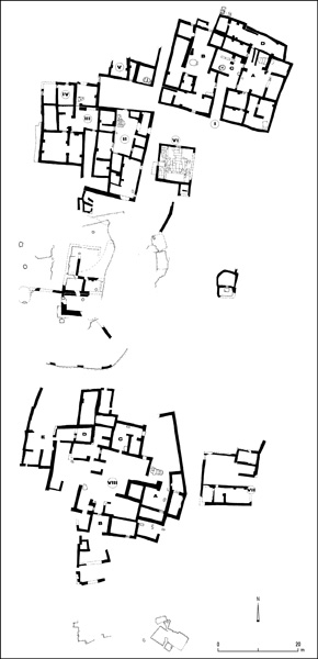
Three seasons of salvage excavations were carried out at the site in 1995–1997 by Y. Magen, Y. Tzionit, and O. Sirkis on behalf of the Staff Officer for Archaeology in Judea and Samaria. The site is divided into three main areas: the central hillock, northern complex (buildings I–VI, including the synagogue), and southern complex (buildings VII–VIII).
EXCAVATION RESULTS
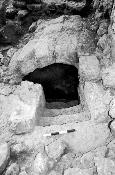
THE CENTRAL HILLOCK. The initial settlement was in a natural cave in the central hillock, where apparently agriculturalists first occupied the site during the Hellenistic period. Later remains from the Early Islamic period were also found inside the cave. Cut into the bedrock on the central hillock were cisterns, a treading floor, and a winepress. A mikveh attached to a large cistern, as well as a large Byzantine winepress, were revealed on the eastern slope of the hill.
THE NORTHERN COMPLEX. The northern complex was the heart of the settlement. Discovered there were six buildings: dwellings, storerooms, a synagogue, and an olive-oil press. The main entry to the site was from the north, through an alley 21 m long by 2.3 m wide. The alley led to two courtyards, one to the west, 14 by 6.5 m, from which three buildings (II, III, and IV) were accessed; and a smaller one to the east, in front of building I and the synagogue. The centrality of the synagogue and the symmetrical construction along its eastern and northern sides attest to the complex having been preplanned. The use of arches is notable, particularly in the synagogue. The walls of the buildings were built of fieldstones, while the doorposts, lintels, and thresholds were of ashlars.
Building I. Building I (28 by 24 m) is situated on the northeastern side of the site. Three “wings” (A, B, and C) belonged to the original structure, while wing D was added later. A corridor (9 by 2.4 m) leads to wings A, B, and C. A cistern lies in the center of the courtyard of wing A (20 by 13 m), the eastern part of the building; to the courtyard’s north is a rock-cut mikveh, covered with large stone slabs. Wing B, the western part of the building, is of similar dimensions to wing A. It has two entrances, from the south and east, both leading into a central courtyard. A hewn but unplastered installation with steps is located in the center of the courtyard. The rooms of wing B were more spacious than those of wing A; they probably were storerooms.
The center of the building has been designated by the excavators as wing C, the olive-oil press (8.5 by 6.5 m). On its eastern side were found two crushing stones on either side of a collecting vat. In the western wall, facing the two stones, was a recess for the press beam. On the southeastern side of the press was a plastered pit where the oil was brought for straining. Near the press was a mikveh used for the purification of those working in the press. The crushing weights were put to secondary use in later constructions, such as wing D (19 by 4.5 m), where one of the press weights was used in a pier of the room. This part of the building also contained many vessels dated to the Late Roman–Byzantine periods.
Building II. Building II (22 by 13 m) is the central dwelling at the site, typical of the Roman period. Its courtyard is surrounded by 10 rooms of various sizes. It was entered on the northern side of the courtyard, where two doorposts and a threshold stone for a single door that opened inward were found. There is a plastered, rock-cut mikveh (11 by 4 m) in the northern part of the courtyard; its steps are narrow and its roof barrel vaulted. A large water cistern is adjacent to it.
Building III. To the west of building II is a large storage area referred to as building III (15 by 15 m), with a courtyard flanked by rooms to its south and west. It was entered from the south through a narrow 12-m-long corridor. Piers of arches that supported the rooms’ ceilings remain on the walls. Upon removal of a later obstruction between the southern rooms, a coin hoard hidden on the eve of the Second Jewish Revolt was discovered.
Buildings IV–V. Three rooms of what is apparently the southern part of building IV were excavated. In the eastern room was revealed a small, plastered mikveh. Four rooms of building V, situated in the northwestern corner of the site, were revealed. North of these was a courtyard where another hoard of coins hidden on the eve of the Second Jewish Revolt was found.
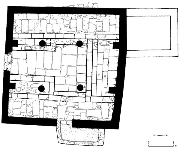
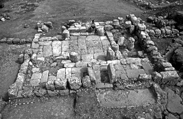
Building VI—The Synagogue. The synagogue, a square public structure measuring 9.6 by 9.6 m, is isolated from the other buildings, yet an integral part of the general plan of the site and contemporaneous with the northern complex. It is fronted by a wide, open space with a floor of beaten earth, from which the synagogue’s molded façade would have been seen. It was entered from the north, via a 1.4-m-wide opening built of ashlar jambs and a large stone lintel bearing a rosette within a triangle in low relief. The jambs and lintel are grooved to receive a wooden door frame. An additional narrower entrance was in the western wall. An ashlar with a tabula ansata was found close to it, probably its lintel.
The synagogue’s walls were built of fieldstones, like the other buildings at the site. It is paved in large, variously sized stones, up to 2 m in length. Two rows of columns, each with two free-standing columns and two piers, stand along a north–south axis. The columns were set directly into the stone paving with no broader base drum. The walls and columns were covered in a thick layer of painted plaster, a red-painted 1.5-cm-thick sample of which was found on the base of the southwestern column base. The piers were topped by simple Doric capitals (found around the synagogue, not in situ), which also functioned as the bases for arches supporting the wooden beams of the ceiling, laid east–west. Two rows of stone benches elevated by one step were found along the eastern and western walls of the hall. The southern wall also contains evidence of once having been furnished with benches, but these were looted in a later period.
A narrow opening in the western wall led to a small (3-by-1.2-m) plastered room, which appears to have been a small pool. To the southeast of the synagogue was a square room built of fieldstones, its entrance not preserved; it was probably used to store ritual objects.
THE SOUTHERN COMPLEX. Building VII. Building VII is located in the southeastern corner of the site, to the east of building VIII. It is built of ashlars laid on bedrock. The pottery it contained indicates that it was in use during the Early Roman period. A jar fragment was found, bearing an engraved inscription of the name “[A]rchelais” in Hasmonean script.
Building VIII. Building VIII, 20.30 by 16.30 m, consists of five wings arranged around a large courtyard. It is equipped with a large cistern in its center. The floor of the courtyard is of leveled and smoothed bedrock. The building’s walls, of large fieldstones, rest directly on bedrock. The building lacks the usual indications of a residence, and is undoubtedly a building of particular importance, probably having served a public function.
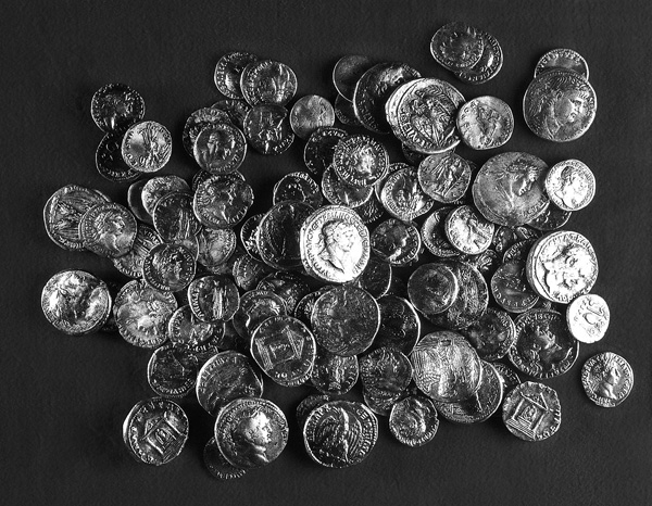
THE FINDS. A rich assemblage of small finds was found on the site, including pottery, stone vessels, a few pieces of metal, glass, and coins. The finds indicate that the site was first occupied at the end of the third century BCE. The main settlement dates from the second half of the first century CE until the beginning of the second century CE, the time of the Second Jewish Revolt. The ceramic and numismatic finds, as well as the stone vessels, attest that the settlement was Jewish. Two hoards of coins were hidden on the eve of the Second Jewish Revolt. One hoard had 144 silver coins, the other 44 bronze coins and one silver coin. The earliest coins found at the site date to the Ptolemaic period, of the third century BCE; there were also Hasmonean, Herodian, Judaea Capta, and later coins. Settlement at the site was renewed in the late third and fourth centuries CE. Some activity during the Islamic and Ottoman periods was also evidenced from the finds.
YITZHAK MAGEN, YOAV TZIONIT
INTRODUCTION
Khirbet Badd ‘Isa is located in the center of the modern settlement of Qiryat Sefer (Ma‘ale Modi‘in), on a hillock 301.15 m above sea level, along the road leading north to Kharbata from the Beth-Horon–Jerusalem route. The site has been surveyed several times and looted over the years. It was first occupied as a temporary agricultural installation at the end of the Ptolemaic period, in the third century BCE. Permanent settlement began at the end of the Hasmonean period and lasted to the Second Jewish Revolt. With the suppression of the revolt, the site was abandoned and reoccupied only in the third century CE.
Three seasons of salvage excavations were carried out at the site in 1995–1997 by Y. Magen, Y. Tzionit, and O. Sirkis on behalf of the Staff Officer for Archaeology in Judea and Samaria. The site is divided into three main areas: the central hillock, northern complex (buildings I–VI, including the synagogue), and southern complex (buildings VII–VIII).