Answers at Lachish
Sennacherib’s destruction of Lachish identified; dispute over a century’s difference in Israelite pottery dating resolved by new excavations; stamp impressions of Judean kings finally dated.
016
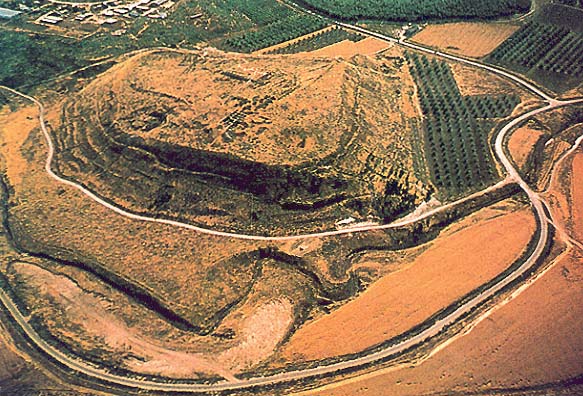
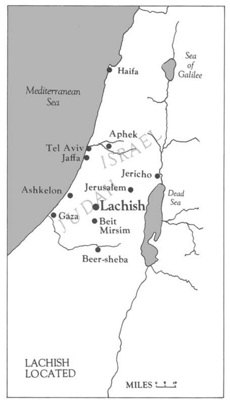
Lachish was one of the most important cities of the Biblical era in the Holy Land. The impressive mound, named Tel Lachish in Hebrew or Tell ed-Duweir in Arabic, is situated about 25 miles southwest of Jerusalem in the Judean hills. Once a thriving, fortified city, the almost 18 acre tela today stands silent and unoccupied.
018
Settlement began here in the Chalcolithic period, toward the end of the fourth millennium B.C. By the third millennium Lachish was already a large city. In the Middle Bronze Age (first half of the second millennium B.C.), Lachish was heavily fortified by a glacisb which gave the mound its present prominent shape. In the Late Bronze Age (16th–13th centuries B.C.), Lachish was a large Canaanite city-state. A few letters from Lachish were found in the 14th century royal Egyptian archives at Tell el-Amarna. They were sent from the Canaanite king of the city to the Egyptian pharaoh.
Lachish played a major role in the story of the Israelite conquest of Canaan as related in Joshua 10. Japhia, king of Lachish, joined an alliance of five kings whom Joshua defeated on the day the sun stood still. After defeating these armies and killing their royal leaders, Joshua proceeded to attack their cities. Lachish was able to defend itself against Joshua’s forces only for a single day. On the second day of the attack, Joshua took Lachish. He destroyed the city and killed its inhabitants. Excavations have confirmed a major destruction level at about this time (12th century B.C.). The archaeological record has also revealed that for about the next 200 years, until the 10th century B.C., Lachish was mostly abandoned.
Following the division of the United Kingdom into Judah and Israel at Solomon’s death, Lachish was rebuilt and heavily fortified by one of the kings of Judah, who turned it into a garrison city and royal stronghold. Undoubtedly the most important Judean city after Jerusalem, the city was defended by two massive city walls, the outer one built half way down the slope and the inner one extending along the edge 019of the mound. A large gate complex on the southwest side protected the city at its entrance. A huge palace-fort crowned the center of the city. Lachish played a major role in Judah until its destruction at the hands of Nebuchadnezzar’s Babylonian army in 588/6 B.C. The city was rebuilt again in the Persian-Hellenistic period (sixth–fourth centuries B.C.), when it served as a district capital. Then it was abandoned forever.
A British expedition headed by James L. Starkey conducted large scale excavations at Tel Lachish between 1932 and 1938. This was one of the largest and most methodical excavations carried out in Palestine before the Second World War. Starkey systematically planned the work many years ahead. He spent the first years principally in preparatory work, away from the mound itself. He dug ancient graveyards in the vicinity of the tel, cleared areas on the slopes, and built a convenient expedition camp. Some, but relatively little, work was done on the mound proper. The excavations, however, came to an abrupt halt in 1938. While travelling from Lachish to Jerusalem, to attend the opening ceremony of the Palestine Archaeological Museum, Starkey was forced by Arab bandits to stop near Hebron. Without warning the bandits shot him dead. After Starkey’s murder, the excavation was wound down, while his assistant Olga Tufnell worked for twenty years on the data and finds, in the end producing a meticulous excavation report.
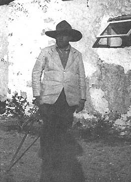
The mound remained untouched until the present excavations, except for a small dig carried out by Professor Yohanan Aharoni of Tel Aviv University on the eastern part of the mound.
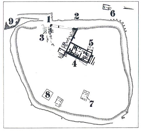
One of the main areas excavated on the mound proper by the British expedition was the city gate complex and the roadway which led to it from outside the city. The city gate is situated near the southwest corner of the mound, and, in fact, the topographical 020lines had revealed its existence even before work began. As often happens in ancient Biblical cities, a number of city gates were found superimposed on one another, each associated with a different occupation level, each having been used during a different period in the city’s history.
The first city gate uncovered by Starkey was naturally the uppermost and the latest one. It dated to the Persian period, and was in use until the final abandonment of the site. This gate and the related level, forming the uppermost archaeological stratum, was labelled Level I by the British. On penetrating further, the excavators found that the Level I gate and roadway were constructed above an earlier gate complex, which was accordingly labelled Level II. This earlier gate had been destroyed in an enemy attack, as evidenced by a thick layer of destruction debris over the remains of the Level II gate.
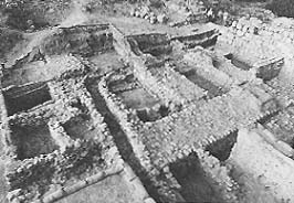
At that point Starkey made his most famous discovery: a small room, later called the guard room, was found within the Level II gate-complex. The floor of the guard room was covered by the ashes of the destruction. Beneath the ashes were sealed hundreds of storage jar fragments blackened by the intense fire which accompanied the destruction. Eighteen of these pottery fragments contained ancient Hebrew inscriptions written in ink. These ostraca, that is, inscribed pot sherds, are known today as the Lachish Letters. They were sent to a military commander at Lachish during the last days of the kingdom of Judah, when Nebuchadnezzar, king of Babylon, had already begun to conquer Judah.

That Lachish was attacked and almost certainly destroyed by Nebuchadnezzar at that time (588/6 B.C.), is proven by the striking words of the prophet Jeremiah (34:7): “And the king of Babylon’s army attacked Jerusalem and the remaining cities of Judah, namely Lachish and Azekah; for these were the only 023fortified cities left in Judah.” The discovery of the ‘Lachish Letters’ in the city gate together with late Judean pottery indicate that the destruction of the Level II city-gate—and the associated city—must be assigned, in accordance with the testimony of Jeremiah, to the Babylonian conquest. From the archaeological point of view, this means that Level II was destroyed and sealed under destruction debris in 588/6 B.C.
As the excavations in the gate area continued, Starkey soon discovered that the Level II city-gate complex was built above an even earlier gate-complex, which he accordingly labelled Level III. This gate-complex was much larger and more massive, and only small parts of it were uncovered by the time the excavations ended in 1938. It was nevertheless clear that the Level III gate had been razed in an intense conflagration. Remains of this terrible destruction were also found wherever the excavator’s spade reached contemporaneous remains in the city. Shops and houses built along the road which led from the gate into the city, the huge fortified palace (probably the seat of the Judean governor), and houses built beside the palace—all had been destroyed and were covered with a fiery debris. It was clear that Level III had been a fortified and densely populated Judean city which was completely destroyed in a fierce enemy attack. The question was: When and by whom was the Level III city destroyed.
By 1937 Starkey’s views had already crystallized. Greatly influenced by William F. Albright’s dating of the Judean levels at Tell Beit Mirsim (situated a short distance to the southeast of Lachish), Starkey suggested in a London lecture that Level III at Lachish was destroyed in the Babylonian campaign of 597 B.C. In that year Nebuchadnezzar besieged and occupied Jerusalem, deposed King Jehoiachin, put Zedekiah on the throne of Judah, and deported a large segment of the population (2 Kings 24:15 ff). Starkey believed that the close resemblance between the pottery of Level III and Level II indicated that a relatively short period must have elapsed between the destruction of the two levels. The dating of Level II to 588 B.C. seemed certain, so this observation concerning the similar pottery fit well with Starkey’s conclusion that Level III must have been destroyed in 597 B.C., only about a decade before the destruction of the superimposed Level II.
When Olga Tufnell worked on the material after Starkey’s murder, she reached different conclusions. In her opinion there was a clear typological difference between the pottery of Level III and Level II. Tufnell relied especially upon material from Level II which had been uncovered in the windup of the excavation after Starkey’s death. Tufnell also discerned two phases in the Level II gate, each of which had been destroyed by fire. If there were two phases within Level II, this made it even more unlikely that only a decade separated Level II and Level III. Tufnell thus concluded that a much longer period must have elapsed between the two levels, and that Level III must have been destroyed much earlier than 597 B.C. She assigned its destruction to the Assyrian conquest of 701 B.C., a famous and well-documented historical event which will be discussed later in this article.
The dispute over the dating of Level III reflected one of the most serious and central dating problems in Palestinian archaeology. So long as it remained unresolved, scholars would disagree by more than 100 years about the dating of Level III pottery. This pottery repertoire had been found not only at Lachish but at a host of other sites as well.
The effort to resolve this dating problem focused primarily on Lachish. In scholarly shorthand the problem was put at countless scholarly meetings and conversations. What was the destruction date of Lachish Level III? The reason the spotlight was directed at Lachish Level III rather than at contemporaneous levels at other sites was because of the clear and unambiguous stratigraphy at Lachish, the rich assemblages of pottery and other finds, and the historical connections of the site. All this turned Lachish into a key site and the question of the date of the destruction of Level III became a problem of sustained scholarly attention. Many famous scholars expressed their opinion on the matter. The 597 B.C. date was supported by W. F. Albright, B. W. Buchanan, G. Ernest Wright, Paul W. Lapp, Frank M. Cross, Jr., H. Darrell Lance, J. S. Holladay, Jr. and Dame Kathleen Kenyon. Dame Kathleen based her opinion on the results of excavations at Samaria, located in the northern part of the country. Samaria, the capital of the kingdom of Israel, was conquered in 026720 B.C. by Sargon, king of Assyria. Dame Kathleen assigned the destruction of Period VI to this event. The pottery of Period VI could thus be securely dated to that time. The Samaria Period VI pottery (c. 720 B.C.) differed sharply from the Lachish Level III pottery, so Dame Kathleen concluded that a long span of time must have passed between Period VI at Samaria and Level III at Lachish. To her, in light of the Samaria Period VI pottery, 701 B.C. was too early for Lachish Level III; therefore the destruction level must be assigned to 597 B.C. In this reasoning, she assumed that pottery styles changed along similar lines in the northern and southern parts of the country—an assumption now known to be of very doubtful validity for many periods.
The 701 B.C. date for Lachish Level III was supported, on the other hand, by Ruth Amiran, Benjamin Mazar, R. D. Barnett, Anson F. Rainey, and especially by Yohanan Aharoni. For more than a decade Aharoni excavated in Judah, studying its history and material culture, and in 1966 and 1968 he carried out excavations on the eastern part of Tel Lachish, in the “Solar Shrine” area. This work added vast quantities of material relevant to the subject. Aharoni believed that sharp differences exist between the Level III and II pottery assemblages, differences which could be easily recognized in contemporary assemblages all over Judah. It thus seemed impossible to him that only a decade separated the two levels.
In 1973 Tel Aviv University’s Institute of Archaeology and the Israel Exploration Society began renewed excavations at Lachish under my direction.c Six excavation seasons were conducted between 1973 and 1978. The next season is planned for the summer of 1980.
The new excavations have concentrated on three main excavation areas or fields, to use the jargon of the trade: (1) the Judean palace-fort and the Canaanite buildings underneath (under the supervision of Christa Clamer); (2) the Judean city gate and its environs (under the supervision of Y. Eshel); and (3) another area at the western part of the mound (under the supervision of Gabriel Barkay). The palace-fort and the city gate areas had already been partially dug by Starkey; here we are continuing his work. In the new area on the western part of the mound, we have dug a relatively narrow trench cutting through the edge of the mound which will eventually extend to the lower slope. Here we hope to penetrate the lower levels of the mound, and get a sectional view of the various levels down to bed rock, following the pattern set by Dame Kathleen Kenyon in her excavations at Jericho. Last year we also started an archaeological survey of the Lachish area (under the supervision of Y. Dagan).d
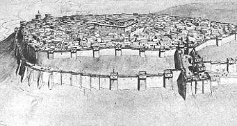
After a few years of systematic digging in these areas the stratigraphic picture of Lachish in the Israelite period including Level III, has now been completely clarified. All the areas uncovered by Starkey at the western part of the mound have been stratigraphically connected to our new excavation areas. All our excavation areas have now been linked to one another through monumental structures: The Judean palace-fort has been connected to the massive wall labelled “the enclosure wall.” The latter, 027crossing our “section area,” has been physically connected to the inner city-wall built along the upper periphery of the mound, which in turn has been linked to the massive city-gate. All these monumental structures may be looked upon as forming the skeleton of the mound. In turn, we established the relationship of each monumental structure to its adjacent habitation levels and accumulated debris, the latter representing the flesh of the mound and providing the relevant stratified data for the related monumental structures. At a number of points the stratigraphy of the mound was checked down to the Late Bronze Age (that is, to the latest Canaanite city level), confirming Starkey’s allocation of six strata between the Late Bronze Age and the Persian-Hellenistic period. In addition, an independent—but similar—stratigraphical picture was observed by Aharoni in his trench at the eastern part of the mound. The following picture clearly emerges:
Level VI represents the final Late Bronze Age (that is, Canaanite) city. At that time Canaanite Lachish reached its prime, a prosperous and flourishing city with a rich material culture. The city came to a sudden end and was destroyed by fire in the 12th century B.C. We believe that this destruction should be attributed to the invading Israelites, as recorded in the book of Joshua 10:31–32.
Level V: Following the complete destruction of the Canaanite city, the site was abandoned until the tenth century, the period of the United Kingdom of Israel. At that time, settlement was renewed, and is represented by Level V. Many small houses were then built all over the site, but no defense wall along the edge of the mound protected the city. This settlement was also destroyed by fire. A monumental structure known as Palace A dates from this period and became the first stage of the Judean palace-fort. It is not clear whether Palace A was contemporaneous with the rest of the Level V houses, or whether it was built after 028their destruction. In either case, we are inclined to assign the construction of Palace A to Rehoboam, since in 2 Chronicles 11:5–12, 23 Lachish is mentioned among the cities fortified by him.
Level IV represents a royal Judean fortified city constructed by one of the kings of Judah who reigned after Rehoboam. We are not sure which one. This city was built according to a unified architectural concept, and—in comparison with other provincial Judean cities—on a grandiose scale. The summit was crowned by the huge palace-fort (Palace B). Auxiliary buildings which served as stables or storehouses flanked Palace B. The city was defended by two rings of fortification walls connected to a massive gate-complex. Many open spaces suggest that at the beginning of Level IV Lachish was probably a garrison city rather than a settlement of the usual type. The city of Level IV probably served as a royal garrison city for a relatively long period of time. Level IV came to a sudden end, but it seems clear that this was not caused by fire. In any case, the data points to the continuation of life without a break at the end of Level IV: The Level IV fortifications continued to function in Level III, and other structures of Level IV were rebuilt in Level III.
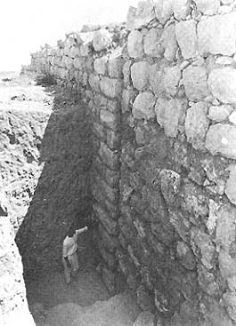
The Level III city continued to function as a royal Judean fortified city. The fortifications and the palace-fort (Palace C) continued to be used with some modifications. The main change which took place was construction of a large number of houses which were uncovered in the area between the city-gate and the palace-fort. The houses are small and densely built, and are quite different from the neighboring monumental structures. These houses, which contained an enormous amount of pottery and other domestic utensils, clearly reflect a substantial increase in the population. An intense fire destroyed all the buildings of Level III, monumental and domestic.
029
An intermediate stage between Level III and Level II consists of a poor habitation level lying on the ruins of the destroyed city gate of Levels IV–III; no fortifications existed at this time.
In Level II the city was partly rebuilt. A new city wall and city gate were constructed. The palace-fort, however, apparently remained in ruins. Houses were built sporadically all around. Level II was totally destroyed by fire, almost certainly in the Babylonian conquest of 588/6 B.C.
Level I represents the post-exilic remains, including the Persian city-walls, city gate, and small palace (the Residency).
Needless to say, from the beginning of our work, the paramount question in our minds was the date of destruction of Level III. It seemed to us that a satisfactory and conclusive solution to this problem could be found only by means of direct stratigraphical evidence recovered from the mound. After a few years of digging and deliberations, and after the stratigraphy of the mound has been clarified as summarized above, we think the problem has been solved. Before presenting the suggested solution, however, I should first set before the reader the events of 701 B.C., which have considerable bearing on the problem.
During the last part of the eighth century B.C. the Assyrian empire was at its prime. Centered in northern Mesopotamia, the area of the upper Tigris River, it politically dominated the entire Near East. In 720 B.C. the Assyrians conquered the kingdom of Israel; the Israelites were deported (and became the ten lost tribes) and the country became an Assyrian province. The kingdom of Judah, however, remained independent for a few more years. In 705 B.C. Sennacherib ascended the Assyrian throne. One of his first tasks was to deal with an alliance against Assyria which included Egypt, some Philistine city-states along the Mediterranean Sea, and King Hezekiah of Judah, who reigned in Jerusalem. In 701 B.C. Sennacherib took on the coalition. The events of Sennacherib’s military campaign are recounted in detail both in the Bible and in contemporary Assyrian records (the different sources are, however, somewhat inconsistent). Sennacherib’s army first marched south from Phoenicia along the sea coast. Here Sennacherib successfully repelled the Egyptian army and subjugated the Philistine cities. The Assyrian monarch next turned on Judah. He conquered most of the country except for Jerusalem, where Hezekiah somehow managed to withstand the siege (see 2 Chronicles 32; 2 Kings 18–19). Sennacherib tells us in his royal annals inscribed in cuneiform that he “laid siege to 46 … strong cities, walled forts and to countless small villages (of Judah) in their vicinity, and conquered (them) by means of well-stamped (earth-) ramps, and battering-rams brought (thus) near (to the walls) (combined with) the attack by foot soldiers, (using) mines, breaches as well as siege engines.” As to the inhabitants, he “drove out (of them) 200,150 people, young and old, male and female, horses, mules, donkeys, camels, big and small cattle beyond counting, and considered (them) booty.” Other Assyrian inscriptions tell in brief that the Assyrian king “laid waste the large district of Judah.” The Bible corroborates the Assyrian sources: “In the fourteenth year of King Hezekiah did Sennacherib king of Assyria come up against all the fortified cities of Judah, and took them” (2 Kings 18:13; Isaiah 36:1; also 2 Chronicles 32:1).

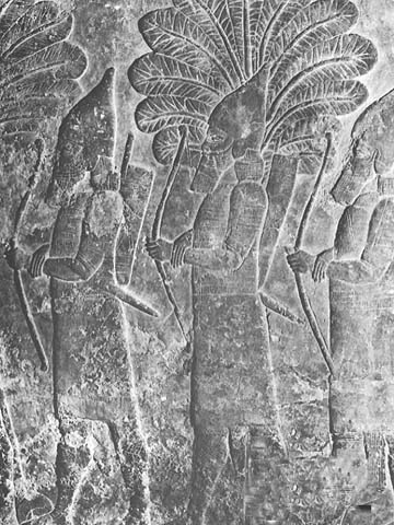
The city of Lachish was one of the conquered Judean strongholds, as we are informed by two different sources. First, the Bible states that Sennacherib camped at Lachish and established his headquarters there, at least during part of his sojourn in Judah (2 Kings 18:14, 17; 19:8; Isaiah 36:2; 37:8; 2 Chronicles 32:9). Second, the famous Lachish reliefs at 031Sennacherib’s palace in Nineveh record the attack and conquest of Lachish.
When Sennacherib transferred the Assyrian capital to Nineveh (modern Kuyunjik), he devoted great effort to beautifying the city, especially by the construction of his royal palace. This extravagant edifice is described in detail in Sennacherib’s inscriptions; he proudly called it the “Palace without rival”! Called the South-West Palace by Sir Henry Layard who excavated it on behalf of the British Museum in the middle of the nineteenth century, the building lends considerable support to Sennacherib’s description. Unfortunately, the science of archaeology was in its infancy in the nineteenth century and Layard’s methods as well as the records he left behind are far below modern standards. Layard did, however, prepare a partial plan of the building and uncovered a large number of stone reliefs adorning the walls.
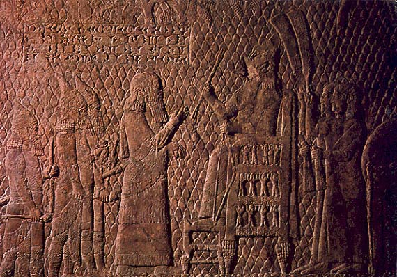
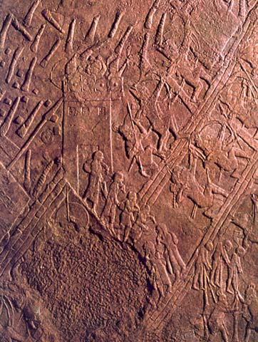
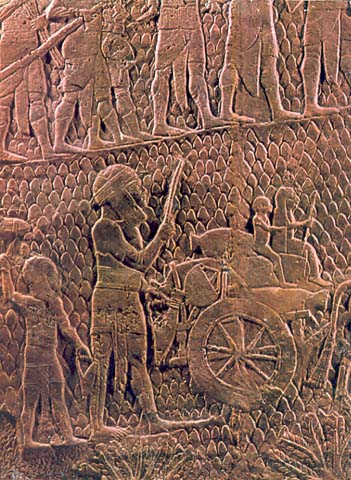
A special room, centrally positioned in a large ceremonial suite of the palace contained the Lachish reliefs depicting Sennacherib’s conquest of Lachish. The walls of this room were completely covered with reliefs in this series. The length of the entire series was nearly 90 feet. The preserved part—now exhibited in the British Museum in London—is nearly 60 feet long. The slabs at the left-hand side have been lost, but according to Layard they portrayed “large bodies of horsemen and charioteers” kept in reserve behind the attacking army. Further along, in consecutive order from left to right, are shown the attacking infantry, the storming of Lachish, the transfer of booty, captives and families going to exile, Sennacherib sitting on his throne, the royal tent and chariots and, finally, the Assyrian camp—almost certainly the camp mentioned in the Bible. One of the two accompanying inscriptions identifies the city as Lachish. The actual storming of Lachish is depicted in the center of the series, opposite the entrance to the room, so everyone approaching the room would see it.

We believe the detailed relief gives an accurate and realistic picture of the city and the siege. The relief conveys to the viewer an impression of the strength of Lachish’s fortifications, as well as the ferocity of the attack. The city is built on a hill, and is surrounded by two high walls shown at the two sides of the relief. In the center of the relief is the city gate, depicted as a free-standing structure. Judean refugees are shown leaving it. An isolated structure above the gate seems to be the huge palace-fort whose remains were uncovered in the excavations. The main Assyrian siege ramp is shown to the right of the gate; here five battering rams, supported by infantry, attack the city wall. A second siege ramp is shown to the left of the gate, and here two more battering rams attack the gate and the wall. The defenders, standing on the walls, are equipped with bows and slings) they hurl stones and burning torches on the attacking Assyrians. Those Lachishites defending the city wall at the point of the siege ramp are throwing burning chariots down on the Assyrians below—probably a last, desperate attempt to stop the Assyrian onslaught. The fact that seven battering rams are involved in the attack—as compared to one or two battering rams which are usually depicted in Assyrian siege scenes—is a good indication of the unusual importance and scale of this battle.
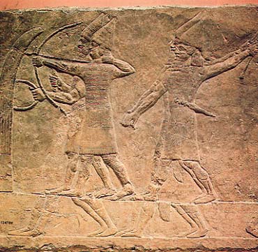
The central architectural position of the ‘Lachish room’ in Sennacherib’s palace, the unusual length of the relief series, the detailed portrayals, the scale of the attack—all this leads to clear-cut conclusions. First, the conquest of Lachish was of singular importance; it may even have been Sennacherib’s greatest military achievement prior to the construction of the royal palace. At any rate, no other campaign of Sennacherib was recorded in a similar fashion. Thus, in 033701 B.C. Lachish was a strongly fortified city, probably the strongest in Judah after Jerusalem. Second, we can conclude that Lachish was conquered, burnt and razed to the ground by the Assyrian army in that year. Although the burning and destruction of Lachish are not specifically recorded in Sennacherib’s annals, and in fact are not shown on the surviving parts of the relief (the upper section of the relief which has not been preserved, however, may well have depicted tongues of fire coming out of the burning city), it nevertheless seems likely, considering the importance Sennacherib attached to Lachish, that the city was razed after its conquest.
In light of the evidence summarized above—historical as well as stratigraphic—the crucial question of the destruction date of Lachish Level III can be resolved. In 701 B.C. Lachish was a strongly fortified city which was conquered and destroyed. Thus there must be a conspicuous burnt level representing this destroyed city. Level VI, as we have seen, is a Canaanite city that was destroyed in the 12th century B.C. and Level II represents the latest Judean city, destroyed by the Babylonian army in 588/6 B.C. This leaves us with three possible “candidates” for the city destroyed by Sennacherib: Levels V, IV and III. The settlement of Level V, possibly unfortified, which is characterized by 10th century pottery, can hardly represent a large, fortified city, and cannot be dated to the end of the 8th century B.C. Level IV apparently came to a sudden end, but it seems clear that this was not caused by fire. Moreover, the city walls and city gate of Level IV continued to function in Level III, and some Level IV structures were rebuilt in Level III. These facts point toward the continuation of life without a break. Considering that the fortifications remained intact, we can hardly identify this level with the city which was stormed and completely destroyed in the fierce Assyrian attack of 701 B.C. Level III thus remains the sole suitable “candidate,” and we have no alternative but to conclude that this is the level destroyed by Sennacherib in 701 B.C.
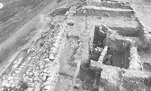
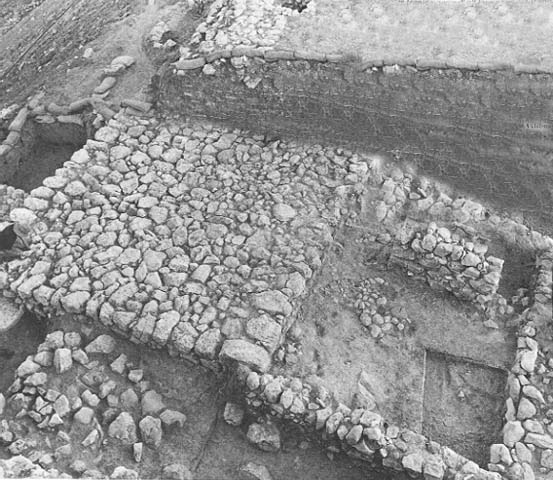
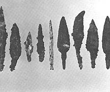
The finds from this level correspond well with the accounts of the Assyrian attack describing the tragic fate of Lachish. The strong fortified city of this level was completely destroyed by fire. The palace-fort and the city gate were burnt down to their foundations, the city wall was razed to the ground, and houses were burnt and buried under the debris. Signs of conflagration are visible everywhere; in some places the accumulated destruction debris—including mud-bricks baked hard by the intense fire—reached a height of nearly 6 feet. The British expedition had the impression that some walls were even pulled down after the collapse of the superstructure. The large number of iron arrowheads found in this level are additional evidence for a raging battle. Pottery and other utensils were found crushed under the debris of the houses. There is no evidence that the inhabitants later tried to retrieve their belongings or reconstruct their homes.
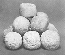
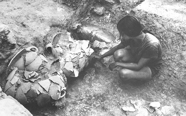
A destruction date of 701 B.C. for Level III also accords better with the findings in the city gate area than a date of 597 B.C. We uncovered much pottery in this area, both in Level III and in Level II. Special mention should be made of two storerooms, one destroyed at the end of Level III and the other at the end of Level II. Both storerooms contained large assemblages of pottery vessels typical of storerooms which had been crushed and buried at the time of their destruction. The pottery repertoire from the later storeroom clearly differs from that found in the earlier one; obviously, it would have taken longer than a decade for these typological changes to have occurred. Also, we found a modest reoccupation on the ruins of the old, Level III gate, before the construction of the new, Level II gate. This reoccupation makes it all the more difficult to suggest that Level II followed Level III within a decade or so. There are simply too many changes for all of them to have occurred in so short a time.
In summary, the following picture emerges. The densely populated and prosperous city of Level III was attacked and conquered by Sennacherib in 701 B.C. Following the battle, the city most likely was sacked, burnt and razed to the ground by the Assyrian army, and then left in ruins. Most of the survivors, if not all, were forced to leave the city. Many were probably killed by the Assyrian soldiers, either in battle, or after having been taken into captivity. The British expedition found evidence for wholesale slaughter in one large tomb which contained a mass burial of about 1500 people. The Lachish reliefs also depict Judean prisoners being impaled and stabbed. Many of the remaining Lachishites were probably exiled and may be numbered among the 200,150 Judean deportees mentioned in the Assyrian inscriptions. The deportation scenes in the Lachish reliefs show large families as they are being driven out of the city, their belongings in their hands, or loaded on ox-carts or camels.
034
Sennacherib tells in his inscription that the towns which he had plundered were given to the Philistine cities along the Mediterranean coast. That is, to Ashdod, Ekron and Gaza. The desolate city of Lachish was probably one of those towns. It is reasonable to assume that the city was left in ruins and deserted during a large part of the seventh century B.C., even though a few people might have continued to live in the destroyed city, as we found in the city-gate area. Similar remains may still be buried in unexcavated areas of the site.
At present we possess no archaeological data indicating when the city of Level II was built, but we may assume that it was only when Lachish was once again part of the kingdom of Judah. Tentatively, we may assign the construction and fortification of the Level II city to King Josiah, who was responsible for so many reforms in the latter part of the seventh century B.C. The Level II city was constructed along different lines from Level III and was apparently much less densely populated.
Securely dating the destruction of Level III enables us to solve many significant historical and archaeological problems. One good example involves so-called royal Judean storage jars.
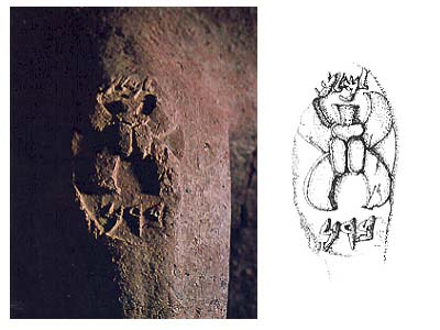
Since the 19th century A.D., storage jar handles with royal Judean seal impressions have been discovered in various sites in Judah. By now more than a thousand such stamped handles are known. These seal impressions include a brief Hebrew inscription and an emblem. The inscription always includes the word lmlk, (the handles are often called l’melekh handles) which means “belonging to the king.” They also include the name of one of four towns, Hebron, Sochoh, Ziph, or mmst (The name mmst is not known from any other source, and its exact pronunciation is unclear). The emblem on these royal handles is either a four-winged scarab or a two-winged symbol, which should probably be identified as a winged sun-disc. Some scholars also distinguish between emblems portrayed in a naturalistic style and those portrayed schematically.
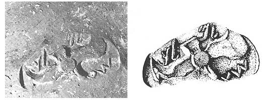
The inscription lmlk indicates the direct connection of the jars to the government of Judah, but the nature and meaning of the connection remains obscure. Some say that the lmlk stamp indicates that the jars were produced in royal potteries: others say this indicates that the jars were associated with royal Judean garrisons; still others suggest that the lmlk stamp means that the produce kept in them belonged to the government. Perhaps the most popular view is that the lmlk stamp constituted a government-certified guarantee of the accurate capacity of the jar or of its contents.
Another uncertainty relates to the four cities which appear on the seal impressions. These cities are relatively unimportant ones, and one of them, mmst, as mentioned above, is not known from any other source. These cities could each represent a government administrative district in Judah, or they could be the sites of the royal potteries, or centers for the production of wine (if that was the commodity kept in these jars).
The distribution of the seal impressions among the various Judean sites where they have been found shows no consistent pattern with respect to the four cities. The seals are not concentrated in the areas of these particular cities, and seal-impressions bearing the names of the different cities are usually found together.
Another problem concerning these storage jars relates to their function. What were they meant to hold? Wine? Oil?
Still another unanswered question concerns the interpretation and meaning of the emblems.
A final and fundamental problem concerns the 035dating of these royal storage jars. During whose reign or reigns were these jars produced? Lacking stratigraphic evidence, the royal jars were usually dated on the basis of historical and epigraphical considerations. Many scholars believed that the royal seal impressions with a four-winged emblem date to the eighth century, and that those with the two-winged emblem date to the seventh century. Other scholars, notably Frank M. Cross and H. Darrell Lance, argued that the stamps of all types were contemporaneously used during the reign of Josiah (seventh century B.C.) and that their use ceased after his reign. Recently, A. Lemaire, who considered the epigraphical evidence, and N. Na’aman, who considered the historical evidence, reached the conclusion that the royal stamps of all types should be dated to the eighth century B.C.
The British excavation had already made clear that Lachish was a key site for solving the dating problems of the royal storage jars. Over 300 of these handles were recovered in the British excavation. In addition, the British archaeologists found 48 handles from similar jars but bearing a “private” stamp (that is, a stamp with a private name). Furthermore, they even restored one jar bearing stamps with the four-winged emblem, one jar with a “private” stamp, and a few jars of that type which were unstamped. The royal storage jars had been very popular in Level III and were limited to that level. As stated by Miss Tufnell, “Nearly all the rooms attributed to city Level III contained at least one example of this vessel, and they were virtually confined to it.”

Here, then, was the first clear example of the royal storage jars which were found in a good stratigraphical context, sealed under the destruction debris of Level III. Nevertheless, the royal storage jars could not be securely dated for two reasons. First, the date of the destruction of Level III was a controversial issue. (Indeed the assumed date of the royal Judean jars based on historical and epigraphic considerations, was often used to argue for one date or another for the destruction of Level III). Second, the majority of the royal stamps recovered at Lachish had a four-winged emblem. Only a small number bore the two-winged scarab, and it remained unclear whether they were stratigraphically associated with Level III or not. The reason for this unusual distribution was not known. Some suggested that the small number of two-winged emblems may have been intrusions from a later date. Thus it was an open question as to whether jars containing the two-winged stamps were used concurrently with jars bearing the four-winged stamps. If the jars bearing stamps with a two-winged emblem were later in date (having been adopted after the destruction of Level III), this would explain why so few of them were found at Lachish.
Tufnell’s report was ambiguous on the question. Lance argued that the data presented in Tufnell’s excavation report indicated that the handles with the two-winged symbol originated in Level III contexts. Aharoni introduced a note of caution by emphasizing that the scholars at that time were basing their arguments not on whole vessels which could form reliable ceramic evidence, but rather with mere handles which could easily be strays out of stratigraphic context.
Our recent excavations added new data which now solves the problem conclusively. In our excavation we emphasize whole pottery restoration wherever possible. The fragments of every vessel which are lying on the ground undisturbed are methodically collected and later restored to the extent that this can be done. In this way, we were able to recover seven whole storage jars containing royal seal impressions as well as a few unsealed jars of a similar type. All these jars (like the jars uncovered and restored by Starkey) were recovered in clear loci of Level III and all of 036them were crushed under and sealed by the destruction debris of that level. Of special interest are two jars which bear seal impressions with a two-winged symbol. One two-winged storage jar was discovered in a storeroom situated behind the gatehouse, together with storage jars which bear royal stamps with a four-winged emblem. The other two-winged storage jar, whose lower part could not be restored, was discovered in one of the gate chambers. Two of its four handles bore seal impressions with a two-winged emblem and the name of the city Sochoh. The other two handles carried a “private” stamp with the name “Meshulam (son of) Ahimelech,” who probably was a government official associated with the “business” of the royal storage jars, whatever that was.
Thus we know that royal storage jars of all types—those without stamps as well as those bearing stamps with a four-winged and a two-winged symbol—were used concurrently in Level III prior to its destruction. This event, as shown above, occurred in 701 B.C., so we must conclude that royal storage jars of all types were used concurrently in Judah during the reign of King Hezekiah. It is difficult to decide whether the royal storage jars of all kinds were produced exclusively during Hezekiah’s reign or not. It is possible that one or more kinds of these storage jars were produced prior to Hezekiah’s ascent to the throne. Moreover, because Lachish was for the most part abandoned after 701 B.C., we do not know whether the royal storage jars were produced and used after that date, that is, during the later part of Hezekiah’s reign, and during the period following his death. In any case, by the time that Level II was destroyed in 588/6 B.C. by the Babylonian army, these vessels were not in use any more in Lachish, and probably not in the rest of Judah.
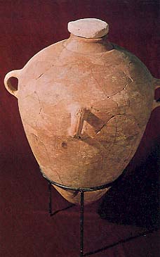
In addition to the royal Judean storage jars, we can now securely date an enormous amount of pottery 038found in the burnt houses of Level III, crushed and sealed under the destruction debris. These vessels were in use in these houses on the day of Lachish’s destruction, so they all must date to the last decade of the eighth century B.C. Thus, we now have a large corpus of well dated Judean pottery which can serve as a bench mark for understanding pottery typology, pottery development and pottery chronology in the entire country during the period of the First Temple. Indeed, the dating of the “Lachish III pottery” (as it is now called) to the eighth century rather than to the beginning of the sixth century (as would have been the case if Level III had been destroyed in 597 B.C.), has resulted in many changes in our understanding of the development of Iron Age pottery in the land of Israel.
Finally, it should be noted that the scholarly debate concerning the destruction date of Level III continues. Our argument in support of 701 B.C., as proposed by Olga Tufnell and Yohanan Aharoni, is based on internal evidence and we strongly believe that this kind of evidence is the most convincing kind. Other scholars, however, believe that the weight of the external evidence is so great that it definitely indicates that Level III was destroyed in 597 B.C. and not before. According to this view, the evidence from Lachish itself presented above must be adapted to fit the external evidence. First and foremost among these scholars is Dame Kathleen Kenyon. She visited our excavation in the summer of 1977. During her visit we had an opportunity to analyze with her the entire question, including its various implications. In 1978 she studied the problem afresh in connection with her work on a revised edition of her Archaeology in the Holy Land. While she accepted the newly uncovered archaeological data as interpreted by us, she nevertheless concluded that the pottery evidence from Samaria is more important. As she wrote me on June 23, 1978, shortly before her untimely death: “I have, of course, been considering the new Lachish evidence very carefully … I still find it very difficult to accept the Lachish III remains as belonging to the Assyrian destruction of c. 700 B.C., both on the grounds given in Samaria-Sebaste 3 (the report on the excavations at Samaria), and because it leaves the seventh century B.C. a complete blank for progress as indicated by pottery forms … I do not have a closed mind on the subject … but I do think that there are problems to be accommodated … ”
Two other distinguished scholars, A. D. Tushingham of the Royal Ontario Museum in Toronto and J. S. Holladay, Jr. of the University of Toronto also believe—on the basis of the evidence external to Lachish—that Level III was destroyed in 597 B.C. In January 1979 we arranged a seminar on the question at the University of Toronto. Chaired by Dr. T. Cuyler Young, the seminar had the opportunity of hearing Tushingham, Holladay and myself present our different views. The seminar aroused much interest, and I hope Tushingham and Holladay will publish their arguments in detail so they can be judged by the scholarly world at large. Although I continue to listen with great respect, I must nevertheless restate my firm belief that the internal evidence from Lachish itself definitely carries greater weight and must prevail over the external evidence: Level III at Lachish was destroyed in 701 B.C.
The Lachish excavations will continue for many years to come. Indeed, we are following a detailed, long-term plan. We hope to uncover much more significant data in the future. The next excavation season will take place during the summer of 1980, for eight weeks, (June 15–August 8). We also plan to excavate during the summers of 1981–1982. We need volunteers to work with us; BAR readers who are interested in excavating at Lachish should get in touch with the project’s U.S. coordinator, Dr. Song Nai Rhee, Northwest Christian College, 11th and Alder Streets, Eugene, Oregon 97401. You will be most welcome. We guarantee an exciting time discovering the past.
Lachish was one of the most important cities of the Biblical era in the Holy Land. The impressive mound, named Tel Lachish in Hebrew or Tell ed-Duweir in Arabic, is situated about 25 miles southwest of Jerusalem in the Judean hills. Once a thriving, fortified city, the almost 18 acre tela today stands silent and unoccupied. 018 Settlement began here in the Chalcolithic period, toward the end of the fourth millennium B.C. By the third millennium Lachish was already a large city. In the Middle Bronze Age (first half of the second millennium B.C.), Lachish was heavily fortified by […]
You have already read your free article for this month. Please join the BAS Library or become an All Access member of BAS to gain full access to this article and so much more.
Already a library member? Log in here.
Institution user? Log in with your IP address or Username
Footnotes
Readers may be confused by the use of the two spellings of “tel” and “tell” to refer to an ancient mound. “Tell” is the transliteration of the Arabic word and is used with an Arabic site name; “tel” is the transliteration of the Hebrew word and modifies a Hebrew site name. When speaking of specific mounds we use the appropriate spellings; but when speaking in general we use “tell.”
A glacis is an artificial ramp built against a slope in order to fortify it. This was the typical fortification used in the country during the Middle Bronze Age.
These excavations are sponsored by a number of public bodies, primarily by the Samuel H. Kress Foundation in New York, as well as The Northwest Christian College in Eugene, Oregon; Central College in Pella, Iowa; Florida College in Florida, and the University of South Africa in Pretoria.
