From Camels to Computers: A Short History of Archaeological Method
044
045
Professional archaeologists are often amused by the popular image many people have of us as fearless adventurers, dashing from one exciting escapade to another like Indiana Jones. Little do they know that our work is often conducted in dusty, out-of-the-way places that hold little interest to anyone but us. Until very recently, our tools have been modest worker’s implements: trowels, picks, levels and buckets. Supplementing these now are a whole array of high-tech machines that are swiftly changing the way we excavate.
How do we really dig? And how have we dug in the past? In BAR’s March/April issue this year, Shlomo Bunimovitz showed how the interpretation of archaeological finds has evolved over the past century (“How Mute Stones Speak,” BAR 21:02). It is appropriate that we now look back at how archaeologists have conducted their excavations and, even more important, survey the new techniques that are taking the study of the past into the future.
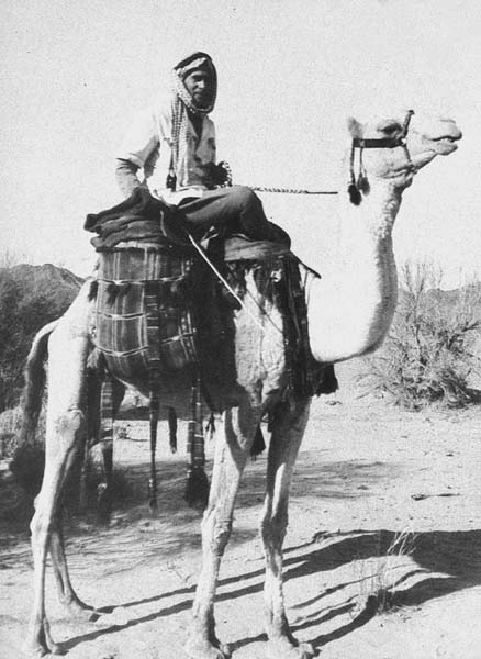
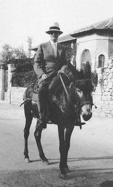
In the early 19th century, adventurers, European colonialists and Bible scholars initiated, somewhat unknowingly, what was to become the science of archaeology. It all began as a kind of pastime, with field surveys carried out from the backs of horses, camels and donkeys, hoping to locate royal cities and other sites mentioned in the Hebrew Bible.
Among the more distinguished pioneers was the American orientalist Edward Robinson and his friend Eli Smith (a fluent speaker of Arabic), who accurately identified hundreds of sites in the Holy Land. The French were represented by the great polymath Charles Clermont-Ganneau. The London-based Palestine Exploration Fund (PEF) sent Charles Wilson, Charles Warren, Claude Conder and H. H. Kitchener (later known for his exploits in the Sudan as “Kitchener of Khartoum”) to the land of the Bible, not only to survey but to dig. Conder and Kitchener’s geographical survey of Western Palestine, started in 1872, recorded more than 10,000 sites. The survey was published in seven volumes, together with a giant map covering an area of some 6,000 square miles. It remained the basis of all topographic maps down to the establishment of the state of Israel in 1948.
As early as 1867, Charles Warren, an officer in the Royal Engineers, made a series of probes in the vicinity of the Temple Mount in Jerusalem. Using his skills as an engineer, he sunk deep, narrow shafts sometimes extending more than 100 feet below ground. At the time, however, there were no methods for dating artifacts or interpreting the layers Warren encountered.
All these explorations were merely the forerunner of the revolution in archaeology resulting from the discovery of ancient epigraphic evidence—hieroglyphics in Egypt and cuneiform inscriptions in Assyria. The subsequent decipherment of these strange writings forever changed how archaeology was to be conducted. For the first time, hard extra-Biblical archaeological data gave historical context and depth to some of the events, peoples and places mentioned in the Bible. For example, the large wall relief from Sennacherib’s palace in Mesopotamia depicts his conquest of Lachish in 701 046B.C.E. and provides extra-Biblical evidence for events mentioned in the Biblical text (2 Kings 18–19).
When epigraphic material provided some firm dates for Biblical events, archaeology could move beyond romantic hunts for treasure to a systematic discipline akin to other forms of scientific inquiry.
The first step in this new direction was taken in 1890 by British archaeologist Sir Flinders Petrie, who attempted to excavate Tell El-Hesi, in the south of Palestine, on the basis of its stratigraphy. Stratigraphic excavation means the careful revealing and recording of layer after layer of superimposed archaeological deposits found in an ancient tell, or archaeological mound.
Petrie also introduced the first systematic typology (the classification of artifacts) of archaeological materials excavated in Palestinian tells. Based on his excavations of Egyptian tombs, Petrie developed seriation studies of artifacts—a dating technique that organizes artifacts in relative chronological order by placing the most similar items next to each other in a series. With both stratigraphy and artifact seriation, Petrie laid the foundation for scientific archaeological field work in Palestine.
Stratigraphic excavation techniques were considerably refined by the American excavations at ancient Samaria from 1908 to 1910, under the direction of George A. Reisner, Clarence S. Fisher and David G. Lyon. Reisner’s great contribution was the development of the debris-layer method of excavating. Reisner insisted on the careful separation of superimposed occupation layers and painstakingly mapped the location of artifacts found in each of the strata. He also developed a detailed recording system, including extensive photographic records, a daily diary, maps, architectural plans and an artifact registry with detailed descriptions of all finds.
The years between the two World Wars were dominated by the towering figure of William Foxwell Albright. Albright was a master of archaeology, biblical history, exegesis, historical topography and epigraphy, to name only a few of the fields he excelled in. He was also the pre-eminent proponent of using archaeology to examine and authenticate the history of ancient Israel. With his vast knowledge of ancient and modern Semitic languages and his own development of archaeological pottery chronologies, especially for the Biblical periods, Albright almost single-handedly advanced the comparative study of Biblical and ancient Near Eastern texts and material culture.
Albright’s excavations at the small site of Tell Beit Mirsim, southwest of Hebron, between 1926 and 1932 provided the evidence for him to refine pottery dating, especially from the second millennium B.C.E. Based on stylistic changes of pottery sherds he excavated at the site, Albright developed a ceramic typology that he then linked to the mound’s various strata or layers.
Tell Beit Mirsim proved to be an ideal site for clarifying the pottery sequence of Palestine because most of the strata were well preserved, relatively even and uninterrupted by late construction. Albright published his revolutionary pottery chronology from Tell Beit Mirsim in the Annual of the American Schools of Oriental Research in 1932 and 1933; even today they serve as ideal textbooks for students of Palestinian pottery. Albright’s carefully curated ceramic collection can still be seen at the W.F. Albright Institute of Archaeological Research in Jerusalem.
During the inter-war years, the field survey also 047emerged as a powerful method of assessing broad regional changes in the history of settlement in the Holy Land. Nelson Glueck, a scholar and rabbi who was deeply influenced by Albright, pioneered the new method. Glueck had worked at Tell Beit Mirsim, where he quickly acquired the knowledge of ceramic chronology that would enable him to date thousands of previously unrecorded sites he found in his surveys. Glueck made his first systematic surveys of eastern Palestine between 1932 and 1947, in Transjordan, the home of ancient Moab, Ammon and Edom. Following the establishment of Israel in 1948, Glueck carried out a series of surveys in the then-wild Negev desert from 1952 to 1964. He collected pottery fragments and photographed and mapped many small sites that previous explorers and archaeologists had missed or ignored. His in-depth knowledge of pottery chronology enabled him to date sites with only a handful of potsherds.
Glueck was both a pioneer field surveyor and a scholar capable of integrating the big picture of cultural change in ancient Palestine. Much of his later work was carried out from a jeep, without the on-foot, meter-by-meter investigation required of archaeological field surveys today. Consequently, a number of Glueck’s conclusions have been challenged. However, all scholars working in the areas where Glueck surveyed acknowledge their debt to his pioneering efforts.
The inter-war years were the period of British rule in Palestine. For the first time, a state-supervised infrastructure for archaeological research was established in the country. In 1929, the American oil baron John D. Rockefeller, Jr., donated a million dollars for the construction and another million dollars for the maintenance and acquisitions endowment of the Palestine Archaeological Museum in Jerusalem, which became the headquarters of the nascent Department of Antiquities. The museum opened in 1938, providing the country with a modern state-of-the-art research center, complete with laboratories, storage rooms, photography labs, library, administrative offices and exhibition halls.
Under the British Mandate many of the most famous Biblical sites were excavated on a monumental scale—Beth-Shean, Tell-en-Nasbeh (Mizpah), Beth-Shemesh, Tell el-Ajjul, Lachish, Samaria, Jericho and Megiddo. In his excavations at Megiddo, P. L. O. Guy, an army officer who became Chief Inspector of Antiquities for the Mandatory Government, gave locus numbers to rooms or distinct cultural features, and for the first time used aerial excavation photography by attaching a camera to a tethered balloon.
A burst of archaeological activity followed the end of the British Mandate in 1948, both in the independent state of Israel and in the Hashemite Kingdom of Jordan.
Perhaps the most influential figure at this time was Dame Kathleen Kenyon, who through her earlier work at Samaria and in the 1950s at Jericho brought the science of recording to the forefront of archaeological research. Earlier excavators had exposed extremely wide areas using large, unsupervised teams of paid workers and gave little attention to what archaeologists today call “site formation processes,” the way in which the archaeological materials and soil were laid down.1 By excavating in much smaller, narrow trenches and squares reaching deep down to bedrock (sometimes over 04850 feet!), Kenyon drew attention to the relationship among deposits, architectural structures and artifacts.
Kenyon plotted her discoveries in three dimensions, using section drawings (vertical views through various layers)—daily top plans (horizontal views at each level), as well as photographs. She maintained that undisturbed walls of earth (called balks) must be left at frequent intervals between excavated sections, thereby preserving evidence of the stratigraphy of the site. She insisted that it was possible to relate all structures or disturbances to evidence in the balks.2 Kenyon’s methods proved crucial in clarifying the relative dating of archaeological layers as they relate to events in the Bible, especially regarding the early settlement of the Israelite tribes in Canaan.
Kenyon’s method was initially developed by her mentor, Sir Mortimer Wheeler, in Great Britain during the 1930s. When it was applied to sites in Palestine, it became known as the “Wheeler-Kenyon” method. From 1952 to 1958, Kenyon’s excavations at Jericho provided the perfect locale for illustrating the strength of her new technique. Through the careful analysis of the stratigraphic profiles and layer-by-layer recording revealed in her narrow trench, Kenyon exposed the misinterpretations of earlier excavators. For example, in re-examining the Late Bronze Age layers of the tell, she was able to show that Jericho’s previous excavator, John Garstang, had misdated fortifications and destruction evidence to Joshua’s conquest of the site.
The foreign influence on archaeology in the Holy Land during the early post-independence years was by no means confined to the British. The American archaeologist G. Ernest Wright further refined recording techniques at his re-excavation of Biblical Shechem. Wright also pioneered the use of a field staff consisting of advanced graduate students and the use of daily pottery-reading sessions. Shechem provided the American model for creating a core staff of specialists who worked together to obtain an interdisciplinary picture of cultural change. A whole generation of American archaeologists in the late 1960s and early 1970s, trained at Shechem, re-investigated with more rigorous methods sites that had been first probed in the late 19th and early 20th centuries—Gezer, Tell el-Hesi, Ai and Ta’anach are examples.
Important as the foreign influences were, the first years after Israeli independence also saw the flourishing of Israeli archaeology. The founders of archaeology in Israel—Benjamin Mazar, Avraham Biran, Eliezer Sukenik, Nahman Avigad, Michael Avi-Yonah, Immanuel Ben-Dor and Shmuel Yeivin—began their careers during the British Mandate and were mostly trained abroad. It was only after Israel’s independence that locally trained Jewish scholars developed a home-grown school of Biblical archaeology. The key figure in this development was Yigael Yadin (1917–1984)—a unique personality who served as the first Chief of Staff of the Israel Defense Forces. After the War of Independence, he soon became the country’s most prominent archaeologist. As an ex-military man, Yadin, like Sir Mortimer Wheeler, had a talent for the large-scale planning of tactics, supplies and people.
Yadin’s excavation of Biblical Hazor beginning in 1955 was the largest archaeological expedition mounted in Israel since the early 1930s. Hazor became an Israeli archaeological field school, the training ground for many of the country’s most prominent archaeologists.
Yadin’s methods revolved around architectural features. In this he was greatly influenced by his architect, Immanuel (Munya) Dunayevsky, who helped direct excavation strategy. Buildings, floors and small finds were related to each other based on architecture rather than on details of stratigraphy.3 This methodology served as an alternative to that employed by the British and Americans, which stressed a more intense vertical view in smaller areas, rather than the horizontally oriented Israeli method. Today, after years of debate and collaboration between Israeli and American archaeologists, however, there is little, if any, difference between them. Each has borrowed the best features of the other’s method.
Perhaps Israeli archaeology’s most significant contribution to Biblical archaeology has been the refinement of regional surveys, recently carried out by scholars such as Israel Finkelstein, Zvi Gal, Adam Zertal, Rudolph Cohen, Mordechai Haiman and others. These surveys have changed our perception of key topics in Biblical studies, such as the settlement of the tribes in the Promised Land. The surveys provide hard archaeological facts to test the many theories concerning the emergence of ancient Israel in Canaan.
In the early 1970s, the American archaeologist 049William G. Dever began calling for a more “secular” archaeological discipline. In response, most American universities have discontinued calling the archaeology of the Holy Land “Biblical archaeology,” referring to it instead as “Syro-Palestinian” archaeology. The change signaled a shift toward broader social and economic questions concerning cultures of the Holy Land that go beyond specific historical issues.a
One of the important reasons for this change in focus—from specific historical questions to broader issues of cultural change—is the rise of the so-called New Archaeology championed in American archaeology. The New Archaeology attempts to apply the techniques of the physical sciences to archaeological methodology and focuses on explaining cultural evolution based on identifying the processes that stimulate change.
The American excavation of Tell Gezer, led successively by Dever, H. Darrell Lance and Joe Seger, pioneered the participation of on-site specialists in ceramics, geology, botany (archaeobotany), animal bone studies (archaeozoology), biological anthropology and other disciplines. The retrieval of so-called eco-facts became an essential part of excavation strategy, referring to non-artifactual organic and environmental remains such as seeds, bones and soils, all of which reflect cultural activities.
Gezer also initiated the concept of a core staff, with a chain of administrative field command. Excavations 050on the mound were divided into fields, with a supervisor (usually a university professor or graduate student) in charge of six to ten 5-by-5-meter squares called an area. Each area had a supervisor responsible for recording the entire excavation process in the area.
In theory, this more meticulous method of recording was meant to correct all earlier interpretive mistakes, with its less rigorous recording methods. In fact, the new method had the negative effect of over-burdening the excavation directors with mounds of un-integrated reports. By having so many different individuals writing reports for each 5-by-5 meter square, it was exceedingly difficult to obtain (in writing) an over-all picture of the history of the excavation area. It could be done, but it took an exceedingly long time to collate all the results into a coherent picture. While five comprehensive final volumes on the Gezer excavations have appeared since 1971, more work needs to be done to complete the report on this major project.
The future trend seems clear—a renewed interest in historical problems and sources will integrate the theoretical and methodological achievements of the past few decades. The framework that will no doubt permeate future research and influence the way we excavate, especially for the Biblical periods, will be rooted in social and economic history more than in political history. The theoretical grounding will be based on the French Annales School of historiography, made famous by Fernand Braudel in his book The Mediterranean.
The Annales School looks for the underlying forces that create change in societies. To identify these forces, the Annalistes rely on carefully examining the full range of historical data related to all segments of a given society—not merely studying the leaders of a society, as was typical of earlier historians. Many Annalistes also incorporate quantitative studies into their research. As Harvard’s Lawrence Stager, one of the first Biblical archaeologists to apply this framework, emphasizes, the Annales School is important for Syro-Palestinian archaeology because of its concern with historical continuity and change on different temporal levels. These include la longue durée, or long-term history, focusing on the slowly changing conditions of geography, environment and climate and the human interaction with them; conjoncture, or middle-term changes related to social, 051demographic and economic history; and finally, événementielle—or short-term, fast-changing events, including political and military history.
Archaeologists will rarely be able to pick up the événementielle. Avraham Biran’s discovery of the “House of David” stela at Tel Danb is one of those rare exceptions.
To answer larger social and economic questions, scholars such as Stager at Ashkelon and the late Douglas Esse at the Early Bronze Age village at Yaqush in the Galilee began moving from the confines of the Gezer method to utilize excavation grids on a scale of 10-by-10 meters. As a result, more architecture, the basic unit for observing ancient social and economic organization, could be exposed. In my own excavations with the Israel Antiquities Authority’s David Alon at Gilat (a late fifth-fourth millennium sanctuary in the northern Negev), where we employ a blend of American and Israeli excavation techniques, we dispensed with the 5-by-5 meter grid system separated by 1 meter balks. Instead we utilize only strategically located balks to answer specific archaeological questions. The result of such larger-scale horizontal exposures is the recovery of more architecture and a more comprehensive view of ancient societies.
Of all the recent changes in archaeological method, one new tool is likely to dwarf all the rest—the computer. These digital workhorses are thoroughly altering the way excavators find archaeological sites; record, interpret and publish data; and share their results. Virtually every major archaeological expedition now working in the Holy Land utilizes computers for some aspect of its research.
Until recently, archaeologists who studied ancient sites in relation to their local setting (soils, elevation, landforms, land use, etc.) had to spend hours cutting, pasting and measuring environmental maps and plotting the sites on them. Today, a new computer technology known as Geographic Information Systems (GIS) removes this tedious hand work and enables researchers to process hundreds of environmental and archaeological facts in seconds.
Gary Christopherson of the University of Arizona works on the Madaba Plains Project in Jordan and is pioneering the use of GIS in the archaeology of the Holy Land. GIS stores information in a series of digital layers, with each map theme (soil type, artifact type, settlement type, etc.) stored in its own layer. Thus, the distribution of Iron Age Collar Rim jars, important for testing ideas on the Israelite settlement, can be overlaid electronically on a series of environmental conditions like special soils that might have been important to ancient nomads. Quantitative analyses can be done with ease. By using GIS, Christopherson’s innovative work is helping to unravel Braudel’s longue durée of cycles of social and economic change in one part of Jordan.
New technologies are helping map sites found in surveys. The Global Positioning System (GPS) was first used by pilots to locate their aircraft in flight. GPS consists of a network of satellites that orbit the earth 064twice a day and transmit precise position information (latitude, longitude and altitude) based on how much time elapses between the transmission and reception of satellite signals. A GPS receiver thus makes traditional survey instruments obsolete. Archaeologists working in the heavily forested areas of the Galilee or in the vast expanse of the Negev desert now have a tool that enables them quickly to locate sites with a degree of accuracy undreamt of five years ago.
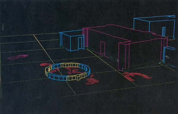
For mapping the topography of sites and the architectural remains exposed by excavation, new survey tools such as an EDM (electronic distance measurer) combine traditional survey instruments with electronics, enabling measurements to be quickly recorded and used in computer-generated maps. The data obtained in this way can later be used to create three-dimensional reconstructions of buildings and other ancient structures. For example, Harrison Eiteljorg II and Andrew Cohen of Bryn Mawr College have used the architectural computer program called AutoCAD (CAD stands for Computer Assisted Drawing) to re-construct in three-dimensions a portion of the Chalcolithic sanctuary at Gilat.c AutoCAD allows the researcher to rotate the model 360 degrees, at any angle and any height. It is an invaluable tool for helping us understand the use of space in antiquity.
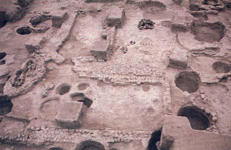
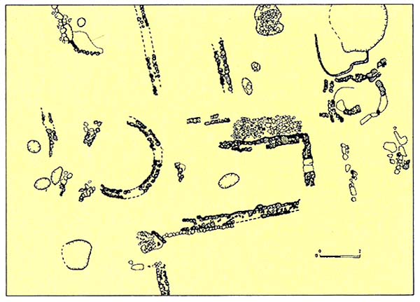
Archaeologists have increasingly turned to remote sensing methods to learn more about sites—even before excavating. Geophysical remote sensing devices involve either passing energy of various kinds (such as radio waves or electrical impulses) through the soil to read what lies below the surface based on the anomalies encountered by the energy, or measuring the intensity of the earth’s magnetic field.4 The choice of method depends on the particular soil involved. Methods based on radio waves and electrical impulses include ground-penetrating radar and electrical resistivity. Magnetic survey instruments include magnetometers, gradiometers and metal detectors. At the enigmatic Early Bronze Age megalithic monument at Rugm el-Hiri on the Golan Heights, a radar survey successfully located the main burial chamber within the monument.d
Another new non-digging technique is called geophysical diffraction tomography (GDT). You may recall a scene in Steven Spielberg’s film Jurassic Park, in which a group of paleontologists use a “seismic gun” to fire explosions into the ground in search of dinosaur bones. In real life, GDT has helped discover the remains of the longest dinosaur, estimated to measure between 130 and 200 feet in length. GDT uses sound waves to identify underground anomalies and produces complete images of sub-surface features on a computer screen.
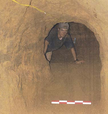
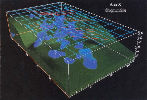
I can testify to the great value of GDT. Since the late 1970s, David Alon and I have excavated at Shiqmim in the Wadi Beer-Sheva, one of the largest Chalcolithic sites in the Negev desert.e In 1989 we discovered that Shiqmim had an extensive subterranean village underneath it, with underground rooms, tunnels and other features. Until then, scholars had assumed that late prehistoric subterranean villages were a highly localized phenomenon found only around the city of Beer-Sheva. Although we had found one complete underground complex of rooms, we wanted to know the extent of these subterranean features: Were there only a few or were they widespread at Shiqmim?
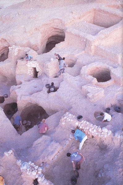
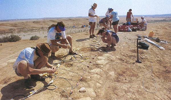
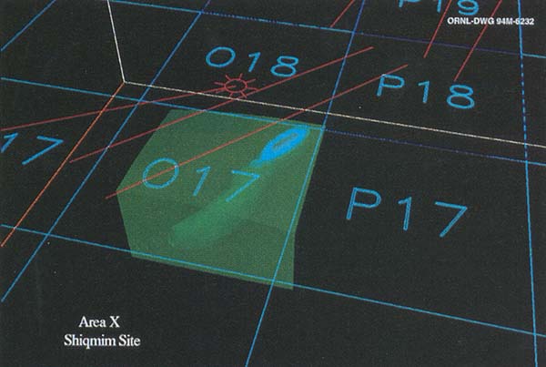
Shiqmim is a huge site of more than 24 acres. The site is too large to be mapped by GDT in its entirety, so we concentrated on sampling one hilltop, about 1,000 feet east of where we had originally found underground rooms. We did not know whether or not there were any subterranean features in this area; we assumed this hilltop was representative of the ten hills that make up a large portion of Shiqmim. Using GDT we made topographic cross-sections or vertical slices. During the evenings, we used a workstation packed into a rental van and loaned to us by the Tel Aviv office of Silicon Graphics Inc. to process the GDT images. Paul White, of Dynamic Graphics Inc., who accompanied us on our expedition, applied Earth Vision software to produce three-dimensional color images of the new subterranean features discovered by GDT. When the field survey was finished, we had a complete three-dimensional image of a honeycomb of subterranean Chalcolithic architecture at one remote hilltop at Shiqmim. After completing the GDT survey, we applied the litmus test, or, in our case, the ground-truth test. Excavation revealed a surface access tunnel leading to a room, as predicted by the GDT image.5
Another area where computers have had a major impact is in the cataloguing and analysis of finds. To understand the ancient social and economic dynamics of a site, archaeologists must be able to detect meaningful patterns in the thousands of artifacts they routinely recover. Pattern detection in large assemblages of artifacts means being able to identify significant relationships between artifacts and such features as architecture, or to identify changes in artifact distribution through time. For example, if collar rim jars are associated with early Israelite settlers at Tel Dan, then pinpointing the changing percentages of these vessels through the Early Iron Age layers at the site will tell us a great deal about the nature of the early Israelite settlement in that region.
When thousands of pottery sherds are found at a site, it is impossible to identify patterns of change over time without the aid of a computer database. Before the advent of personal computers, archaeologists working in the Holy Land had an excuse for why their analyses took so long. Today, with lap-top computers in the field, it is possible to make a typology of artifacts (pottery, flint tools, palettes, bricks, you name it) by entering the attributes of that data (size, weight, color, material and so on) into the database and immediately run simple statistical distribution studies or complex analyses.
During last summer’s excavation at Nahal Tillah in the Negev, we recovered 51,611 pottery sherds, weighing almost a ton. After our pottery analysts, Yuval Yukuteli and Eric Kansa, identified them by ware type, ceramic type, decoration and other variables, the data were entered in the computer. Within a month of the excavation we had a complete study of the Nahal Tillah pottery ready for publication.
At Gilat, we found over 2,000 special artifacts that we divided into about 25 categories, all related to cult activities. By using a spreadsheet program, we could easily manipulate the information on this vast array of objects and identify significant trends in the data. For example, our assemblage includes 82 stone palettes (artifacts with prestige and cultic significance in Predynastic Egypt). The stones themselves are of 21 different rock and mineral types, each associated with a specific geographic region in southern Israel and Jordan. With this data, we prepared a pie-diagram identifying the range of geographic contacts between Gilat and other areas during the fourth millennium B.C.E.
Like most researchers, archaeologists are also busy zooming onto the “information superhighway.” Many BAR readers are already on this highly touted digital expressway, either through on-line commercial services or through the Internet. Archaeologists are connecting their homes, offices and even field computers with larger computers at other locations that store software, documents, electronic mail and other services. The Ancient Near Eastern bulletin board, admirably coordinated by Charles E. Jones of the Oriental Institute of the University of Chicago, provides a forum for discussion, job listings, excavation opportunities, new discoveries and a host of other information. You can subscribe through E-mail by contacting: cejo@midway.uchicago.edu.
So much information is being dumped on the “information superhighway,” however, that we need navigational tools (directories, maps, etc.) and an index to help us exploit 065the full potential of this information storehouse. In October 1994, an index called Abzu, a Guide to Resources for the Study of the Ancient Near East, was posted in an experimental form on the World Wide Web (WWW). It is the first exclusively electronic publication of the Oriental Institute.
Like many similar documents, Abzu is written in “html”—hypertext markup language. This allows the user to select a given title in a bibliography and have it immediately transported to his or her screen. Many of these documents are book length. It is also possible to view photographs and other graphics through Abzu, enabling the user to make on-line comparisons of different artifacts. You can look at Abzu via its Universal Resource Locator’s E-mail address (http://WWW-oi.uchicago.edu/OI/DEPT/RA/ABZU/ABZU.HTML). If you don’t have access to World Wide Web, contact your local service provider and ask for instructions on how to connect to this Brave New World.
Joe D. Seger and Paul F. Jacobs, of the Cobb Institute of Archaeology at Mississippi State University, have created an on-line, Interactive Electronic Technical Manual (I.E.T.M.) generally referred to as the Lahav DigMaster, after the site in Israel where Seger digs. The Lahav DigMaster is interactive and gives access to its database to archaeologists all over the world. Researchers will be able to study and manipulate the data as well as add new information to form a cumulative database.
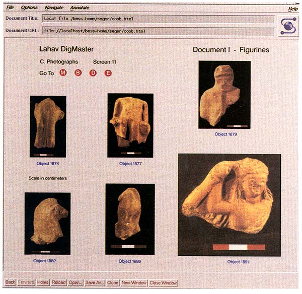
The Lahav DigMaster already contains, for example, a large corpus of ceramic figurines from the Persian Period (550–330 B.C.E.) The sharing of excavation results in this way will speed up the publication process, as well as provide a more comprehensive database for comparative purposes.6
A note of caution, however: there is no peer-review of materials entered into these electronic information systems. Ensuring the reliability of the data is still a problem.
With the growing importance of electronic media for recording and transmitting information, it is now possible to sit in San Diego or Boston and communicate on a daily basis with researchers in Jerusalem and Beer-Sheva. As we rapidly become what Marshall McCluhan called the Global Village, our new technologies will enable us to create more comprehensive understandings of the ancient world. Nevertheless, for the foreseeable future at least, nothing is likely to replace the hard work and sweat of a trowel-wielding field archaeologist.7
I would like to thank Chuck Jones, Gary Christopherson, Joe Seger and Paul Jacobs for sharing their experiences on the Information Superhighway with me. In addition, I appreciate Michael Meeker’s sober views of these developments.
Professional archaeologists are often amused by the popular image many people have of us as fearless adventurers, dashing from one exciting escapade to another like Indiana Jones. Little do they know that our work is often conducted in dusty, out-of-the-way places that hold little interest to anyone but us. Until very recently, our tools have been modest worker’s implements: trowels, picks, levels and buckets. Supplementing these now are a whole array of high-tech machines that are swiftly changing the way we excavate. How do we really dig? And how have we dug in the past? In BAR’s March/April […]
You have already read your free article for this month. Please join the BAS Library or become an All Access member of BAS to gain full access to this article and so much more.
Already a library member? Log in here.
Institution user? Log in with your IP address or Username
Footnotes
As one of Dever’s students at the University of Arizona back in 1975, I found this socio-economic view of the past extremely refreshing.
See “‘David’ Found at Dan,” BAR 20:02.
See Harrison Eiteljorg II, “Reconstructing with Computers,” BAR 17:04.
See Yonathan Mizrachi, “Mystery Circles,” BAR 18:04.
See Thomas E. Levy, “How Ancient Man First Utilized Rivers in the Desert,” BAR 16:06.
Endnotes
Colin Renfrew and P.Bahn, Archaeology—Theories, Methods and Practice (London: Thames and Hudson, 1991), p. 487; M.B. Schiffer, Formation Processes of the Archaeological Record (Albuquerque, NM: University of New Mexico Press, 1987).
P.R.S. Moorey, A Century of Biblical Archaeology (Louisville: Westminster/John Knox Press, 1991). See also: Philip J. King, American Archaeology in the Mideast—A History of the American Schools of Oriental Research (Winona Lake, IN: Eisenbrauns, 1983) and Neil A. Silberman, Digging for God and Country; Exploration, Archaeology and the Secret Struggle for the Holy Land, 1799–1917 (New York: Knopf, 1982).
A.J. Witten, T.E. Levy, J. Ursic and P. White, “Geophysical Diffraction Tomography: New Views on the Shiqmim Prehistoric Subterranean Village Site (Israel),” Geoarchaeology 10:185–206 (1995).
Joe E. Seger and Paul F. Jacobs, “Lahav Digmaster-An Interactive Electronic Technical Manual Database” NEH Proposal, (Starkville: Mississippi State University, 1994).
