
1988 Excavation Opportunities
Hi-Tech Archaeology: Ground-Penetrating Radar—New Technology Won’t Make the Pick and Trowel Obsolete

“This is marvelous! You won’t have to dig anymore. You can just sit back in the shade and look at the pictures that machine will take for you.”
The visitor to our excavations at Lahav, Israel, last summer was looking at a ground-penetrating radar unit that was being pulled across the terrain near our excavation areas. Recently developed, this electronic equipment allows us to “look” below the surface of the soil to locate archaeological features.
Like many others when they first hear about this new archaeological tool, our visitor misunderstood what its impact would be on the digging process. If anything, ground-penetrating radar will lead to more—not less—digging.
First, let me give a brief (and not too technical) description of this new technology. The principle is simple enough: Electromagnetic pulses (short wavelength electric energy bursts) are transmitted into the soil; “echoes” from these pulses bounce back and are measured by a receiver. The velocity of the pulses will be affected minutely by features in the soil that either provide greater resistance (such as stone walls) or less resistance (such as the space in a cistern or tomb chamber). What is detected in the “echoes” is not actually the features themselves, but the planes of interface between layers of material with differing densities. When the pulses hit these interfaces and change velocity, some of the electromagnetic energy is reflected back, producing the “echo” effect. This explains the formal name adopted for this new technology: “Subsurface Interface Radar,” or SIR.

As the transmitting/receiving unit is moved across the ground, the transmitter sends out its pulses at the rate of 50,000 per second, and the receiver measures in nanoseconds (a nanosecond is one-billionth of a second) the time it takes for “echoes” to return from interfaces that are encountered. The echo-time can thus pinpoint the depths in the soil of different interfaces, and these depths in turn can be graphically recorded on a continuous roll of paper, much like an electrocardiogram printout. By pressing a button at periodic intervals as the equipment is moved across a marked path, a vertical line is added to the SIR printout sheet, which will help locate the exact point along the path at which different features were encountered.
SIR was initially developed during the Vietnam War, when there was need for a compact device that could be carried over an area to detect the presence of land mines. Since then, the technology has been used in numerous peacetime applications. It has been used by construction crews to locate underground pipes, by geologists to find mineral deposits, and by police squads to locate criminal burials. Only very recently, however, have the applications of SIR to archaeology been tested. To our knowledge, the only archaeological use of it in Israel prior to our experiments at Lahav last summer was at the Sepphoris Project in 1985.1
The unit that Joe Seger, the director of the Lahav Research Project, arranged to have brought to our site last summer was one that belongs to the United States Department of Agriculture. The operation was supervised by a soil scientist from the USDA, James Doolittle, assisted by Frank Miller of Mississippi State University’s Department of Forestry. Over a period of two weeks during our digging season, they cheerfully pulled their magic red box back and forth over the terrain adjacent to several of our digging fields. Probes were then dug at a number of points where the SIR unit had recorded the suggestion of a possible feature beneath the surface, so that we could determine exactly what the electronic equipment was “seeing” in the soil. As a result, we learned a great deal about the potential of this new technology—and about its limitations.
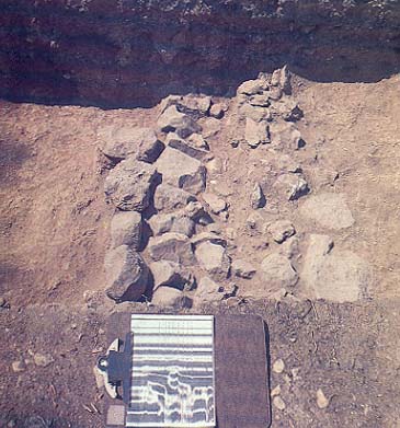
We learned that, on the one hand, SIR can enable us to find archaeological materials with speed and efficiency. On the other hand, only digging can identify what the electronic “shadows” in the soil represent. Alongside one of our digging fields at the upper edge of the tell at Lahav, the SIR unit recorded the signature of a major feature but could not indicate exactly what it was. Within five minutes of opening a probe at that point, we uncovered the top of a massive Iron Age cistern. We would not have thought to find a cistern at that spot, and the area was one we had not planned to excavate; but we had to dig to find out what it was.
I was particularly intrigued by the SIR results in my excavation area, next to the ancient tell. We had been investigating a cluster of large grain silos and a large stone wall, all from the Early Bronze I period (c. 3000 B.C.), at the edge of a broad terrace. But an important question was still unanswered: Was this an isolated installation or part of a general settlement? The silos and wall, it seemed, were too substantial not to be part of a larger complex, but trial trenches that had been dug elsewhere in the vicinity had failed to uncover other buildings.
In less than two mornings, Jim Doolittle and Frank Miller pulled their equipment over a dozen long transits slicing across the terrace around us and gave us some tantalizing results. They were able to pinpoint a number of places where sharp interfaces of some kind were encountered only a foot or so beneath the surface in a zone covering over 100 feet. Moreover, the SIR did not detect any evidence of features farther downslope than the contour line on which our large wall lay.
We then sank three probes at places where the SIR had suggested features lay and, in fact, found architecture less than a foot below the surface in all three cases. In each, the associated pottery was Early Bronze I, contemporaneous with the silos and wall already uncovered.
Now we look ahead eagerly to more digging on that terrace, knowing that an extensive EB I settlement will likely be uncovered. And we know in advance where its outer limits lie, so we also know where to concentrate our energies and where not to waste our time digging.
Here, then, is an instance where the result of “looking” into the soil with SIR will lead to more rather than less digging. Without this advance information, we might well have been discouraged by our earlier probes from investing more seasons of effort on that outer terrace.
But the information provided by SIR would remain tentative and incomplete unless followed by good old-fashioned dirt archaeology. Without digging, we would not learn what kind of features lay beneath the ground, since the electronic signals cannot distinguish between, for instance, a stone wall and a thick cobblestone surface, or between a small cistern and a large tomb. Even if further refinements of the process eventually enable us to make these kinds of distinctions, SIR signals cannot sort out the phasing between several layers of a wall or surface closely overlaid. And, of course, SIR cannot retrieve the pottery or other objects that might date an installation or the artifacts that might help us reconstruct a picture of the human activity that was carried out there. These objects “flesh out” the mute remains in the earth and give meaning to the whole archaeological process. Only the objects sealed within the ancient ruins can tell us when a wall was laid, where an oven was used or a loom set up, when a house was burned or what its last occupants had left behind. To learn these things we still need to dig.
And that’s good news. The Lahav visitor who misconstrued the value of ground-sensing technology also misunderstood something else: Most of us who spend our summers digging in ancient dust do so because we enjoy it. We would miss the three-dimensional jigsaw puzzle, the excitement of discovery, that sense of coming into immediate touch with a part of our past—all those things that come with handling the pick and trowel.
Please join the BAS Library or become an All Access member of BAS to gain full access to this article and so much more.
Already a library member? Log in here.
Institution user? Log in with your IP address or Username