018
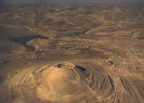
At Herodium, the isolated mountain palace-fortress complex originally created by Herod the Great in the midst of the Judean desert,1 an underground tunnel system dating to the Bar-Kokhba revolt, the Second Jewish Revolt against Rome (132–135 A.D.), has recently been discovered. Unlike the low, narrow underground burrows Amos Kloner describes in “Name of Ancient Israel’s Last President Discovered on Lead Weight,” that protected the rebels’ hiding places during the revolt, the tunnels at Herodium are roomy passages averaging 4.5 feet wide and 6 feet high. Through this network, men could walk or run erect, as lookouts on the fortress towers directed the transfer of men and supplies to meet a Roman assault.
An understanding of the underground tunnels at Herodium and how they worked requires us first to 020understand the artificial mountain constructed by Herod the Great about 150 years before Bar-Kokhba’s rebels dug their tunnels at Herodium.
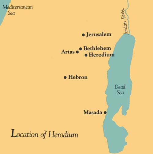
Herod built Herodium about the year 23 B.C.,a according to Josephus, the first-century Jewish historian. A magnificent palace protected by a mountain fortress, Herodium was a district capital as well as a memorial intended as Herod’s tomb. Josephus tells us that Herod was actually buried there, but so far we have not found his tomb—though not for lack of looking. The spectacular, cone-shaped mountain, the crown of Herodium, still dominates the skyline eight miles south of Jerusalem and three and a half miles east of Bethlehem. But Herodium actually consists of both a palace-fortress within the artificially created mountain and a lower palace complex at the base of the mountain.
The mountain palace-fortress sits on top of a natural hill to which Herod made his dramatic addition. The main feature of the mountain palace-fortress is a cylinder-like structure. The cylinder, approximately 200 feet in diameter, consists of two concentric circular walls with a corridor 11.5 feet wide between the two walls. Originally this cylinder rose about 90 feet above bedrock. Between the two concentric walls were seven stories or levels—two substructural cellars with barrel-vaulted ceilings and five stories of corridors that also served as storage areas. Today the two or three uppermost stories are no longer extant.
On the outside of the cylinder wall, four prominent towers command a wide view of the surrounding countryside. The towers precisely mark the points of the compass. Three of these towers are semicircular and are built against and bonded to the outer cylinder wall. Originally each tower contained about 20 rooms. The fourth tower, on the east, is unique. It is round, not semicircular, and extends through both the inner and outer cylinder walls. Up to a height of 60 feet, it appears to have been completely solid. The rest of the assumed stories (another 70–75 feet) were a palatial apartment. Some have speculated that the solid base of this tower is somehow related to Herod’s tomb.
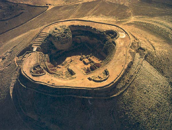
When the cylinder wall and the tower were completed, a massive fill of earth and gravel was added on the outside, giving the impression of a mountain, albeit artificially created. The fill reached to about the cylinder’s fifth floor, or to approximately two-thirds of its height. Thus, only about one-third of the cylinder wall was exposed after the fill was heaped up outside. Inside the cylinder, Herod built a spacious, private palace on a level platform he created on top of the natural hill. The outside fill reached three stories above this platform, imparting to the huge structure a cone-like shape, with the palace inside, far below the top of the wall. The mountain, even today, resembles a volcano with the remains of the palace inside its crater.
Herod’s private palace was intimate, exotic and well protected. It was divided into two equal halves: in the eastern half was a spacious courtyard, and probably a garden; the western half contained the living quarters, including an elaborate Roman bathhouse.
The palace could be entered in only one way: by a steep, straight stairway nearly 500 feet long that went 021directly up the mountain, first outside for about 300 feet, then through a tunnel in the mountain for the remaining 200 feet.
At the foot of the mountain, integral to the mountain palace-fortress, Herod built a complex of structures that we call Lower Herodium. The most prominent feature of Lower Herodium was a great pool, 135 feet wide by 210 feet long. Originally the pool was fed by an aqueduct carrying water from springs 3.5 miles away at Artas. The pool, with an island pavilion in the center, served as a water reservoir, a swimming pool, a lake for small sailing boats and as an architectural focus for Lower Herodium.
Between the pool and the mountain, just at the foot of the mountain, are the remains of a huge building. More than twice as large in area as the entire mountain palace-fortress, this building must have been Herod’s principal palace at Herodium.
In front of this lower palace was an 1,100-foot-long artificial terrace, dubbed by us “the Course.” Of uncertain purpose, the Course was architecturally linked to a massively built, square structure at its western end that we call the Monumental Building. Inside the Monumental Building we found a single large hall enclosed by half columns set on pedestals with niches between them. The hall had plastered walls, originally covered with frescoes.
Following the exposure of the Monumental Building, my thinking was shaped by a strong conviction that somewhere inside or near this building I would discover the elusive tomb of Herod. We even speculated that the Course was built as the parade ground for Herod’s elaborate military funeral, described in detail by Josephus. But for all our efforts and hopes, so far we have found no tomb.
Although the mystery of the location of Herod’s tomb is still unsolved, a clue has been found that strengthens my conviction that somewhere near the Monumental Building and the Course we will one day find the tomb of the great king. Just north of and 022adjacent to the Monumental Building we discovered magnificent ashlar stones, with well-carved margins and raised central bosses, reused in the wall of a fifth-century A.D. Byzantine church. Unique at Herodium, these stones must have been used in a building with a monumental facing surpassing anything found so far at Herodium, perhaps the entrance facade of Herod’s tomb. Another structure recently exposed here was a large well-designed ritual bath, which might also belong to a well-planned tomb complex.
As at all desert locations, the residents of Herodium had to make provisions to bring water to the site and to store it in a way that was accessible. To insure a constant and adequate supply of water to the mountain palace-fortress, especially in time of trouble, Herod cut four large underground water cisterns into the mountain.
In the discussion following, you will be helped by referring to the plan below and to the reconstruction drawing (see sidebar). Identification numbers mentioned in the article will be found on these drawings. Other features are identified by name. A blue tint distinguishes the underground structures built by Herod.
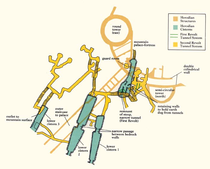
Three of the four cisterns, numbered 1, 2 and 3 were located close to one another, about 80 feet below the mountain’s summit. The fourth, which we have named the “intermediate cistern” (number 4), is located above the other three, closer to the summit (about 16 feet under it). Each of the three lower cisterns was accessible from an opening to it on the flank of the mountain (see picture B).
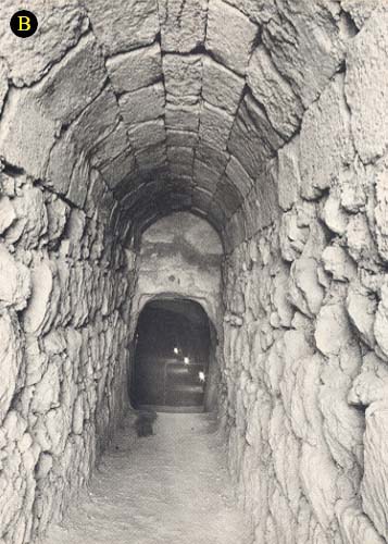
As can be seen on the plan and the reconstruction drawing, the three lower cisterns were located adjacent to the stairs which provided the only access to the mountain palace-fortress. And even the intermediate cistern is quite close to this stairway. I suspect that this is not coincidental. Probably the cisterns were cut before the stairway, and the stairway was located so as to be close to the cisterns, which provided the mountain palace-fortress with its water.b This would explain the seemingly odd location of this stairway, on the northeastern side of the mountain. One would have expected it to be closer to the buildings of Lower Herodium, located somewhat to the west at the foot 023of the mountain. As it is, from Lower Herodium one must walk part way around the mountain to get to the stairway to go up to the mountain palace-fortress. The stairway was probably built in this location so water could easily be brought from the cisterns up to the mountain palace-fortress via the stairway.
Cistern number 2, the central of the three lower cisterns, was the largest: 97 feet long, 16 feet wide and 32 feet high. Its capacity was about 400,000 gallons.
The westernmost cistern, number 1, was 75 feet long and 12 feet wide, with an estimated capacity of 200,000 gallons.
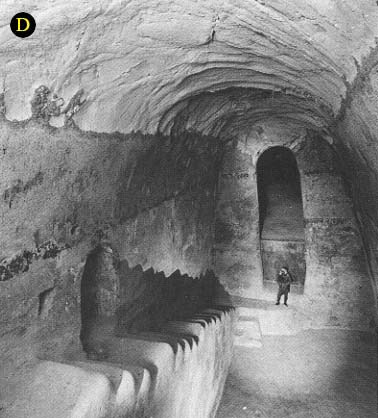
Cisterns 1 and 2 are each divided into two sections by bedrock walls near the middle that jut out of the rock from opposite sides. The walls do not meet. Consequently a passage remains for water to flow between the two sections of the cisterns. (See picture D.)
Cistern number 3, the eastern cistern, has been only partially excavated, but it seems to have been much smaller than cisterns 1 and 2.
During Herod’s time the cisterns within the mountain received their water from two sources: rain falling upon the mountain, which was directed into the cisterns, and from the Spring of Artas, south of Bethlehem. An open channel from the Spring of Artas connected to the large pool in Lower Herodium. From there, donkeys or mules carried the water up the mountain to the cistern openings on the flank of the hill, where the water was poured into the cisterns.
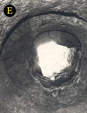
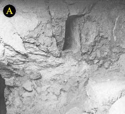
Simply bringing water to the cisterns was not enough, however. The cisterns were deep within the mountain and inaccessible to the residents inside the mountain palace-fortress. Herod’s solution was to construct an intermediate cistern (4) with a vertical shaft (see picture E) from the palace courtyard down into it. Through this shaft a bucket on a rope could be dropped into the water of the intermediate cistern and then pulled up to the courtyard. But this gave no access to the three lower cisterns (1, 2 and 3). The only way to make use of the water from the three lower cisterns was to walk out of the palace on the steep entrance stairway, to proceed to the lower cisterns through their openings on the mountainside and to bring out water in waterskins, jars or buckets. This water would then be carried up the steep entrance stairway to a point near the intermediate cistern where the water would be poured into it through a funnel and thus be made available from the palace courtyard inside the mountain palace-fortress. The funnel probably started on the side wall of the entrance corridor, through which the upper part of the steep entrance stairway passed, and ended on the side wall of the intermediate cistern. The funnel’s entry into the intermediate cistern is still extant and can easily be observed (see picture A). The remainder of the funnel no longer exists. This arrangement, which made use of the intermediate cistern, eliminated any need for Herod’s water carriers to enter the luxurious palace area.
After Herod’s death in 4 B.C. the mountain palace-fortress apparently continued in use, as suggested by the finds in the excavation of this area. It was still in use at the time of the First Jewish Revolt against Rome in 66–70 A.D. At that time the water system, which had been planned for Herod’s needs, raised some problems. It became dangerous to have to go out in order to bring water from the lower cisterns. Recognizing the need for safer access to the water in the three large cisterns below the intermediate cistern, the rebels of the First Revolt constructed a steep, narrow tunnel from the floor of the lowest vaulted story between the two concentric cylindrical walls that surrounded the mountain palace-fortress, digging directly down to one or two of the large cisterns on the lower level. The original entrances into the lower cisterns on the flank of the mountain were probably blocked and camouflaged. The steep, narrow tunnel gave direct, though inconvenient, access to the water in the lower cisterns from inside the walls of the mountain palace-fortress, without the need to go outside the fortress. And the intermediate cistern could still be reached from the shaft in the peristyle courtyard.
Ultimately, the First Jewish Revolt failed before the massive power of Rome. It is likely that in the years following the revolt Herodium lay partially in ruins. Some parts, however, including the substructural cellars, were still intact in 135 A.D. when, once again, Jews rose up against Rome, led this time by Bar-Kokhba. In this Second Jewish Revolt an intricate network of tunnels was built within the mountain.
For some reason still unexplained, the rebels of the Second Jewish Revolt did not use the four large cisterns within the mountain for water storage, as they had been previously used. We know this because they dumped the debris from their underground tunnels into the cisterns.c Presumably the rebels of the Second Jewish Revolt used for water storage not only the small cisterns on top of the mountain itself and on top of the round tower, but perhaps also some still undiscovered cisterns elsewhere inside the mountain.
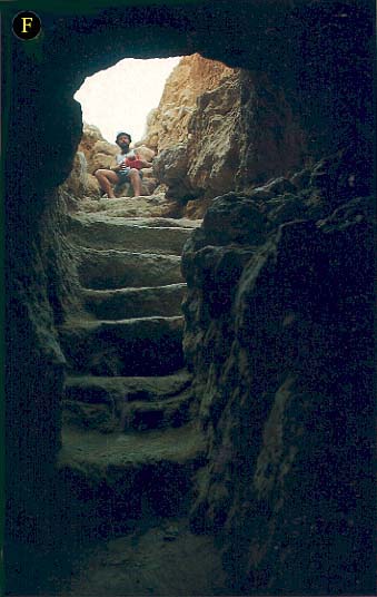
The Second Revolt tunnel system (colored yellow on the plan and drawing) begins in the mountain palace-fortress courtyard. It begins with a flight of stairs (see picture F) about 40 feet long and goes straight down into the intermediate cistern. The upper part of the stairs was cut into the fill below the courtyard; the lower part is cut into the rock.
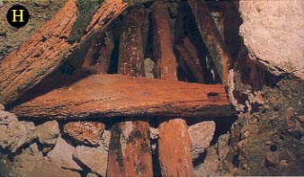
Another, much longer tunnel connects the intermediate cistern with the three large lower cisterns. As noted above, the tunnel diggers dumped the dirt and debris dug from these tunnels into the cisterns, which were no longer 032used to store water. Instead they appear to have been used only as passages, storage areas and gathering places for the rebels. Apparently they didn’t want to take the debris outside the mountain because that might have revealed what they were doing. Most of the tunnels were cut into soft bedrock; others were cut into the artificial fill surrounding the mountain. When the tunnels were cut into this fill, upside down U-shaped wooden frames placed at intervals of 2 to 2.5 feet were used to reinforce the unstable fill. The rebels probably used wooden planks (see picture H) that originally served as ceiling beams in Herodian buildings at the site. Most, but not all, of the wood used this way was rotted when we found it, but even the part that rotted away left its imprint in the tunnel walls.
The underground system of tunnels may be most easily understood by looking at it in four sections: the main tunnel leading from the palace courtyard into the intermediate cistern; the group of tunnels surrounding the intermediate cistern (cistern number 4); the northeastern tunnels around cisterns 1 and 2; and the tunnels related to the easternmost cistern (cistern number 3).
As noted above, the main tunnel from the summit begins with a flight of stairs about 40 feet long, starting at the eastern side of the peristyle courtyard of the palace and going straight down to the edge of the intermediate cistern. At the point where the tunnel enters the cistern, a small room (8 feet by 6.5 feet) was carved into the cistern’s side wall—probably to serve as a guard room at this vital point. From here, for about 32 feet, the tunnel incorporated a section of the intermediate cistern until a point at the side of the cistern, named by us the “bridge junction,” after the bridge built by us to allow ourselves safe access.
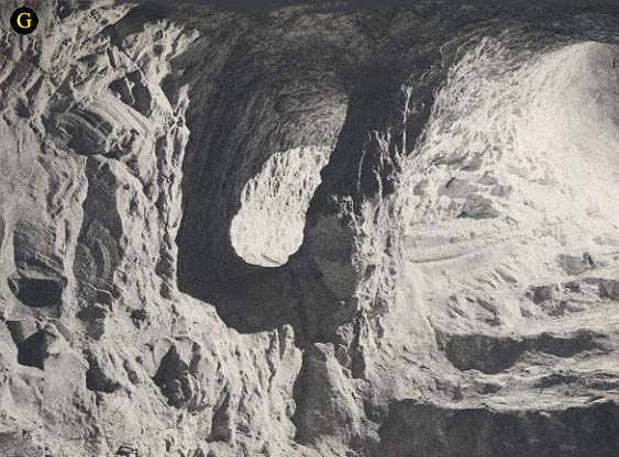
From the bridge junction the main tunnel descends further underground for 200 feet to the lower, larger cisterns (1, 2 and 3). All along this last section, from the bridge junction to the lower cisterns, the tunnel follows generally the course of the steep narrow tunnel (colored green on the reconstruction) carved out from the basement floor during the First Jewish Revolt. But whereas the First Revolt tunnel was very steep, in fact nearly vertical in its upper section, the new tunnel followed a more moderately sloped spiral. During the construction of the later tunnel, most of the steep, narrow tunnel from the First Revolt was “swallowed,” except for a few short sections left useless at the sides of the new tunnel (see picture G). The new tunnel’s entry into the large, central cistern (number 2) was direct; a 36-foot spur off of the main tunnel led to cistern number 1.
In the complex of tunnels surrounding the intermediate cistern (number 4) we found some “false” starts that led only into impenetrable hard flint. Other tunnels seemed to be heading toward an exit on the mountain’s slope, but large quantities of fill blocking the tunnels prevented us from excavating them at this time.
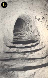
Near cisterns 1 and 2, another group of tunnels begins with a long straight stairway (see picture L) ascending for 42 feet from the southern edge of cistern 2. Then the tunnel turns east for 13 feet and then again to the north, ascending for another 10 feet. The main tunnel continues horizontally for about 45 feet, turns southeast for 10 feet and then resumes a northeast direction for about 30 feet. Three tunnels, all going toward the northeast, branch off of the main tunnel.
We cleared the two easternmost tunnels and discovered to our surprise, at the point where the tunnels meet, an original outlet to the surface of the hill. The outlet was by a shaft whose side walls were reinforced with rubble stones. It was the discovery of this surprising outlet that ultimately suggested to us the purpose of this intricate network of tunnels: The tunnels were used to move men and supplies quickly to wherever they might be needed in the event of a Roman assault.
There must have been many such outlets. We explored a number of branch tunnels, indeed we may have found several that we initially interpreted only as “false” starts, because they are now blocked by debris. Others were in fact “false” starts because the tunnelers ultimately found themselves blocked when they ran into impenetrable flint.
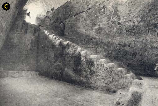
The tunnels around the easternmost cistern, cistern 3, have only begun to be explored. We know that connecting tunnels were cut between the northeast corner of the central cistern (2) and the eastern cistern (3) (see picture C). One tunnel probably went to the surface of the hill, the other to the eastern cistern.
033
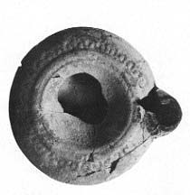
What evidence do we have that the underground tunnels were built at the time of the Bar-Kokhba revolt? Could they not have been the hiding places of the Jews in 66 A.D. at the time of the First Revolt? The evidence is clear, both direct and indirect. The direct evidence is objects found within the tunnels. Although artifacts were sparse, we did find some lamps typical of the Bar-Kokhba period—lamps that were vital to illuminate the dark tunnels. Moreover, no artifacts from the First Revolt were found in the tunnels.
In addition, it is clear at both Herodium and at Masada, where rebels held out at the time of the First Revolt, that they used existing buildings with only minor modifications to fit the existing buildings into their residential or religious needs. The steep, narrow tunnel, allowing direct access from inside the basement floor between the cylinder walls down to the lower cisterns, was a vital addition to avoid the danger described above (having to go outside to reach the lower cisterns). It was certainly not dug by Herod. It was unplanned—typical of First Revolt improvisation. The large, roomy tunnels we date to the Second Revolt, however, have no parallels from the First Revolt. And, indeed, they cancelled out the earlier tunnel, confirming its attribution to the First Revolt.
Both the early third-century Roman historian Dio Cassius and the evidence from archaeological research agree that there were many underground constructions in Judea in the days of the Bar-Kokhba revolt. Dio Cassius wrote in Roman History, that the Jews:
“did not dare try conclusions with the Romans in the open field, but they occupied the advantageous positions in the country and strengthened them with mines and walls, in order that they might have places of refuge whenever they should be hard pressed, and might meet together unobserved under ground; and they pierced these subterranean passages from above at intervals to let in air and light” (69.12.3).d
We also have evidence of the presence of Bar-Kokhba’s rebels at Herodium from the famous documents found by Yigael Yadin and other scholars in the Judean desert caves. In one of these documents—a deed to agricultural land—the beginning of the document as read by Yadin is as follows:
“‘On the 20th of Shevat, Year Two of the liberation (or: redemption) of Israel by Shimeon ben Kosiba [Bar-Kokhba], President of Israel. In the ramp which is at Herodium, Yehuda, son of Rabbah said to Hillel son of Garis. … ’”
According to Yadin, the deed was issued at Herodium; another reading, by J. T. Milik, identifies Herodium as Bar-Kokhba’s residence. In either case, Herodium was clearly a base of action during the rebellion against Rome.
Could the tunnels be later than the time of Bar-Kokhba? Excavations at Herodium, particularly Lower Herodium, reveal intensive occupation during the Byzantine period. But no artifacts from this time have been found in the tunnels. We conclude that the underground system at Herodium was not built by the Byzantines and, in fact, it was probably concealed from the Byzantine settlers. Otherwise, they would surely have left some evidence of their presence in the tunnels, as they have everywhere else on the site. After the Byzantine period, the site remained unoccupied until modern times.
We can only speculate about the purpose of these Second Revolt tunnels, about the strategy of the small band of people who were determined to stand up to Rome on an isolated mountain in the Judean wilderness. The entire underground system of tunnels and cisterns was apparently built to allow rapid movement by the defenders. The tunnels were high. In steep tunnels stairs were carved eliminating the need for ladders or ropes. In sections where the floor was not solid, wooden planks filled the gaps.
Although we don’t know what system the builders of the tunnels used while digging—surveying, following voices, or intuition—we do see clear signs that they were familiar with the unique structure of the mountain. Wherever possible they avoided cutting their tunnels through the artificial fill, which required reinforcement with wooden frames; they preferred cutting through the soft limestone bedrock.
Based on our intimate knowledge of these tunnels over many years, we think we know what the rebels were trying to accomplish. They hoped to control not only the top of the mountain, which they occupied, but also the slopes by means of many camouflaged access points. When the Roman attack would come, watchmen in the towers of the mountain palace-fortress could give directions to the defenders within the mountain. The rebels could then move quickly through the tunnels into the nearly hidden openings on the flank of the mountain. A few warriors could defend the small entrances into the tunnels. With both the advantage of surprise and of being higher on the slope from where they could roll boulders on the attackers, Bar-Kokhba’s followers hoped to overcome the climbing units of Roman soldiers.
Bar-Kokhba failed to overcome the Romans. That we know. But we don’t know—either from our archaeological research or from historical sources—whether the elaborate system at Herodium was ever put to the challenge. Nor do we know, if it was, how the Jews fared. Nevertheless, the tunnels at Herodium, like the burrows described in Amos Kloner’s article, stand as monuments to the morale and determination of the rebels led by the legendary Bar-Kokhba.
At Herodium, the isolated mountain palace-fortress complex originally created by Herod the Great in the midst of the Judean desert,1 an underground tunnel system dating to the Bar-Kokhba revolt, the Second Jewish Revolt against Rome (132–135 A.D.), has recently been discovered. Unlike the low, narrow underground burrows Amos Kloner describes in “Name of Ancient Israel’s Last President Discovered on Lead Weight,” that protected the rebels’ hiding places during the revolt, the tunnels at Herodium are roomy passages averaging 4.5 feet wide and 6 feet high. Through this network, men could walk or run erect, as lookouts on the fortress […]
You have already read your free article for this month. Please join the BAS Library or become an All Access member of BAS to gain full access to this article and so much more.
Already a library member? Log in here.
Institution user? Log in with your IP address or Username
Footnotes
See Ehud Netzer, “Searching for Herod’s Tomb,” BAR 09:03.
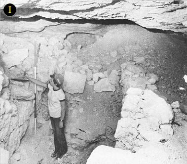
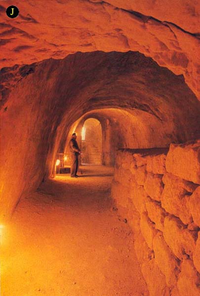
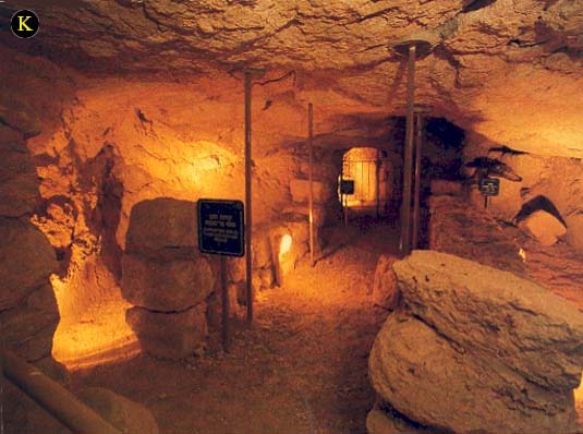
When we first began excavating the intermediate cistern, we thought that it was subdivided by a series of walls made of rubble stone. We assumed that the cistern included a group of rooms in its latest phase. After further excavation, however, we have concluded that the walls do not subdivide courts, rather they are a means of disposing of surplus material. The space between the two central walls was used as a corridor, whereas the spaces behind the walls were filled. The walls within the intermediate cistern were built very poorly. (See pictures I, J, K.)
Endnotes
The system of underground tunnels was first revealed in 1968, when, under the archaeological direction of Gideon Forester, Israel’s National Parks Authority was preparing the mountain palace-fortress, excavated in the 1960s by Father Virgilio Corbo, for tourists. The system was surveyed and partially excavated under my direction with the assistance of Shimon Arzi and the Field School in Kfar Etzion during 1973–1975. The work at the tunnels was carried out by local volunteers who stayed at the Field School.
