
Kathleen Kenyon’s Anti-Zionist Politics—Does It Affect Her Work?
003
What is not in doubt is that Kathleen Kenyon is virulently anti-Zionist. The more subtle question is whether this affects her work as an archaeologist. It is not hard to find Israelis who think it does. Others suggest it is only a professional cantankerousness that so often sets her against Israeli archaeologists. In any event, important questions of archaeology and history are at stake.
Several years ago, a rumor circulating among Israeli archaeologists had it that Miss Kenyon had written an article entitled “From Jericho to Deir Yassin”. When the walls of ancient Jericho came tumbling down, the Israelites destroyed the entire population of the city (except for a prostitute who had served as an informant and her family); Deir Yassin was an Arab village in which women and children were killed—whether by members of the Haganah or by Stern Gang terrorists is disputed—during the Israeli War of Independence in 1948. Deir Yassin has become a slogan but it was in fact an isolated incident in which, as one Israeli put it, the Jews behaved as the Arabs so often did.
Crystal Bennett, current director of the British School of Archaeology in Jerusalem was asked about the rumor that Miss Kenyon had written an article with such a title. Mrs. Bennett answered my query at afternoon tea with other members of the staff of the British School: Miss Kenyon had not written an article with such a title and in fact did not write about politics. A member of the School’s staff then suggested that the title of the rumored article was the kind of language Miss Kenyon might have used in private conversation. No one disagreed.
In a book written shortly before the 1967 war (entitled Jerusalem—Excavating 3,000 Years of Historya), Miss Kenyon describes the two parts of divided Jerusalem. One part she refers to as the “Arab city”: the Old City within the walls and the area to the north. The new areas west of the Old City which had been part of Israel since 1948, she calls “the Israeli-occupied part” of Jerusalem (p. 12).
Yet on any list of great living Biblical archaeologists, Kathleen Kenyon would be very near the top. As a field archaeologist—as an expert in excavating techniques—she probably has no peer. As a historian and an interpreter of archaeological data she is one of the most respected voices in academia. She is also often at loggerheads with Israeli archaeologists.
One of Miss Kenyon’s greatest achievements is the development—together with Sir Mortimer Wheeler—of an excavation method that is used almost exclusively in the Middle East and elsewhere. It is known as the Wheeler-Kenyon method. This method consists of laying out 5-meter squares over the area to be excavated, and leaving so-called balks or cat-walks between the squares, thus forming a grid. The 5-meter squares are excavated, but the balks are not—at least initially, for they form a record of the various strata which lay within the excavated square. This emphasis on careful and precise stratigraphy is in sharp contrast to simply digging and looking for artifacts and architectural remains and to the so-called “trenching” method, in which trenches are dug, especially against walls, thus leaving no record of the strata abutting the wall. Miss Kenyon’s stratigraphic method requires slow, careful excavation, detailed field records, and frequent drawing of stratigraphic sections.b
004In her newly-published book Digging Up Jerusalemc, Miss Kenyon writes of trenching as “a cardinal sin in modern archaeology,” for “to dig a trench along the face of a wall … thereby … cuts through the surfaces related to the wall, either as running up it [and therefore later than the wall], or as having been cut by it [and therefore earlier than the wall]”. Miss Kenyon goes on: “One hears ultra-modern excavators saying that this is old-hat, and I regret to learn that this tendency is growing amongst Israeli archaeologists” (p. 76). Israeli archaeologists deny the charge.
Miss Kenyon’s new book is particularly critical of Professor Benjamin Mazar who heads the current excavations at the Temple Mount—which Miss Kenyon calls by its Arab name, the Haram esh-Sherif or simply Haram, although it was built by Herod the Great for the Jewish Temple. (Miss Kenyon usually prefers the Arab name; even the Biblical Spring of Ein Rogel, she identifies as Bir Eyub, although in the west it is almost unknown by that name.) Miss Kenyon tells us that the area southwest of the Temple Mount has been “stripped”, not excavated, by Professor Mazar (p. 217). She can place no confidence in his conclusions because of “the complete lack of stratigraphical evidence” (p. 217). And again: “The problem of whether [certain vaults which Mazar found were in fact subterranean] would require more precise stratigraphical evidence than we have so far had available” (p. 218). Later, she tells us: “Excavation in such terribly complicated areas of successive destruction, building states, and occupation levels requires a detailed and very patient excavation technique that he [Mazar] did not employ” (p. 218). It is probable, she says, that he misses important archaeological evidence because his “clearance has been on much too rapid and large a scale for exact stratigraphy” (p. 277).
In a recent article in the Hebrew journal Qadmoniot, Professor Mazar describes his excavation technique: “Attention has been focused upon stratigraphy throughout the area of excavations”. However, privately many Israeli archaeologists agree that Mazar is not a great field archaeologist. But, they add, his shortcomings, whatever they may be, do not characterize Israeli archaeology as a whole and even he is not as bad as Miss Kenyon says he is.
Miss Kenyon is the daughter of Sir Frederic Kenyon, a Director of the British Museum and a leading authority on Biblical manuscripts. Miss Kenyon received her training at Roman sites in Britain and elsewhere, and she applied the methods she learned and developed to Palestinian sites. She served on the staff of excavations at Samaria during the 1930’s. In 1951, she became Director of the British School of Archaeology in Jerusalem. From 1952 to 1958, she directed now-classic excavations at Jericho, and in 1961 she began major excavations in and around Jerusalem, particularly in the oldest part of the ancient city known as the Hill of Ophel or the City of David. After the Six-Day War in 1967, Miss Kenyon found herself with an excavation located in the State of Israel, a place where she had never dug before. She completed the 1967 season and retired as a field archaeologist. She is now principal of St. Hugh’s College, Oxford. In 1973, Miss Kenyon, like her father before her, was knighted—in recognition of her enormous contributions to archaeology in general and Biblical archaeology in particular. She is now known as Dame Kathleen.
Miss Kenyon has written a number of popular and semi-popular books on archaeological method, on Middle Eastern history, and on her own excavations at Jericho and Jerusalem.
One inevitably compares her new Jerusalem book, Digging Up Jerusalem, with another book just published, entitled Jerusalem Revealed.d A project of the Israel Exploration Society, Jerusalem Revealed is a collection of 33 articles by Israeli archaeologists on excavations in and studies of the Holy City between 1968 and 1974. One might expect considerable overlap between the two books. But that is not the case: the Kenyon book and the Israeli book are like two ships passing in 005the night; the only contact is a few toots of the foghorn. In part this is understandable. The Israeli book is primarily a discussion of recent finds and their bearing on particular archaeological problems. Kenyon’s book purports to include a history of archaeological excavations in Jerusalem. What scant attention she pays to the post-1967 period focuses on her disagreements with the conclusions of Israelis.
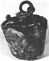
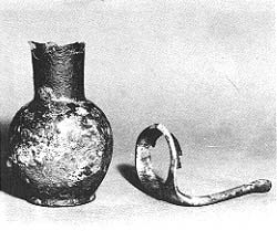
It is perhaps natural that Miss Kenyon writes primarily of her own excavations rather than the many Israeli excavations since 1967, when Miss Kenyon ended her dig. This may explain—at least in part—what she stresses and what she ignores. For example, she devotes several pages of her new Jerusalem book to her 1966 discovery of two bronze buckets and a bronze jug. She describes how she received an “urgent message” after returning from a lunch at Government House with U.N. General Odd Bull to come immediately to the field to view the find in situ. She describes how the bronze buckets and jug were “freed and cautiously lifted out”. She tells the “romantic saga” of the journey of the buckets and jug to the British Museum laboratory for analysis. Finally, she discourses on the “wide significance” of the find as evidence of “ordinary household equipment” of the period c.800 B.C. (see illustration).
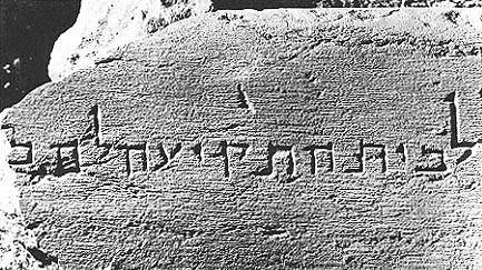
The story is interesting and important. Yet such accounts become a study in contrast when, for example, Miss Kenyon fails to give even passing mention to Mazar’s discovery of the top cornerstone of the Temple Mount of Herod’s temple. Into this large stone was carved a niche where the priest stood when he blew the shofar or ram’s horn to usher in the Sabbath—all as described by the first century historian, Josephus. On the stone is inscribed in beautifully preserved Hebrew letters, “To the place of the blowing of the trumpet.” (The Hebrew word on the stone for “the blowing of the trumpet” is takiya, the same word which to this day calls forth the first blast of the shofar during the High Holy Days in synagogues the world over.) Mazar found this stone among the rubble in the Herodian street below the Temple Mount, where it had apparently fallen during the Roman destruction of Jerusalem in 70 A.D.
Another of Mazar’s more spectacular finds is a fragment of a stone vessel marked “Korban” in Hebrew (“sacrifice”). The vessel may well have been used in the sacrificial service of the Temple before it was destroyed. Incised on the vessel are two birds—doves or pigeons—so the vessel may be connected with the traditional offering of these birds on the birth of a child. This find also goes unmentioned in Kenyon’s 1974 book.
 |
 |
According to Yigael Yadin in the Foreword to Jerusalem Revealed, “The 007archaeological activity in Jerusalem between 1968 and 1974 has revealed more of the city’s past, within the Turkish walls, than did all the excavations in the same area in the last one hundred years.” To read Miss Kenyon’s book, one would never know it. Surely she would not agree with Yadin’s assessment that Mazar’s excavations are “the greatest archaeological enterprise Jerusalem has ever witnessed.”
It would be wrong to search for political bias in all of the disagreements between Miss Kenyon and Israeli archaeologists. Indeed many of these disagreements have no conceivable political implications. We may consider several examples. One disagreement involves “Robinson’s Arch”; another, the question of who built that part of the Temple Mount wall north of the so-called “straight joint”; a third involves the so-called Royal Tombs of the Kings of Judah.
Robinson’s famous arch is not really an arch; it is the bare spring of an arch, projecting from the western wall of the Temple Mount. Beneath the spring of the arch, a row of squared stones projects from the wall—corbelling which decorated the underside of the arch. This vestige of a once-magnificent arch was identified in 1837 by the great American orientalist Edward Robinson whose travels mark the beginning of modern archaeology in Palestine. The arch—or what is left of it—is named after him.
Before Mazar’s recent excavations, it was generally accepted that this arch was only one of a number of arches which in Herodian times extended westward from the Temple Mount, through the central valley of Jerusalem (the Tyropoean Valley, which in this area of the city has largely been filled in modern times), to what is called the Upper City. This series of arches, it was thought, supported a bridge leading from the Temple Mount to the fashionable Upper City.
Mazar’s Temple Mount dig included the area west and south of Robinson’s Arch. To the west, he found the massive pier on which the other side of Robinson’s Arch once rested. But further west, he found no trace of other equally large piers of the supposed additional arches which were thought to support a bridge to the Upper City. Instead, south of Robinson’s Arch, Mazar found piers of descending size, supposedly supporting arches of descending size. This led Mazar’s architect, an Irishman named Brian Lalor, to conclude that Robinson’s Arch supported, not a bridge, but a monumental staircase which went west over Robinson’s Arch and then turned south descending into the valley on the gradually decreasing arches that Mazar found. Beneath the stairs, Mazar found evidence of shops where ritual objects and offerings may have been sold to pilgrims preparing to ascend the Temple Mount.
The evidence of the stairs is too strong to dispute. In Miss Kenyon’s words, “One must accept Professor Mazar’s conclusion that these represent the support of a flight of stairs leading up from the south to reach the level of the Temple, carried on Robinson’s Arch”. But Miss Kenyon still maintains that Robinson’s Arch also supported a bridge to the Upper City. In other words, the stairway south descended into the valley from the bridge. But the bridge, according to Miss Kenyon, continued westward. If only a stairs were needed, reasons Miss Kenyon, it would have been built adjacent to the Temple Mount wall; there was no reason to go west and then south as this magnificent stairway obviously did; therefore it must have continued west as a bridge. What about the lack of any evidence of supporting arches for this bridge to the west? Miss Kenyon’s short answer to this is that she doesn’t trust Mazar’s negative evidence.
Another disagreement between Miss Kenyon and an Israeli scholar involves the question as to who built a particular part of the extant eastern wall of the Temple Mount. The wall of the Temple Mount is in effect a retaining wall. In order to create a flat area on which to build the Temple, a high retaining wall had to be built around the rocky summit of the hill. Then the area was filled in. The area referred to as the Temple Mount is the area enclosed by this retaining wall. The Western Wall, or Wailing Wall, sacred to the Jews, is part of this retaining wall; the Western Wall is not, as so many tourists think, part of the Temple itself. Not a stone of the Temple—either the First Temple or the Second Temple—009has been found, and its exact location on the Temple Mount is still in dispute.
Both King Solomon and King Herod built a Temple Mount. Herod’s Temple Mount doubled the size of the Solomonic Temple Mount and in fact buried it. Herod increased the size of the Temple Mount on the north, south and west, but not on the east. Thus, none of the northern, southern or western walls of the present Temple Mount (including the famous Western or Wailing Wall), can be Solomonic because they are not built on the line of the Solomonic Temple Mount. However, the eastern wall of the Solomonic Temple Mount lay on the edge of a crest which descended steeply down to the Kidron Valley, and Herod could not extend the Temple Mount on this side. But no Solomonic masonry can be seen above present ground level on this wall. Presumably, the foundation of the eastern wall, if it could be explored, would be found to be Solomonic—at least to the point where Herod made his additions to the north and south.
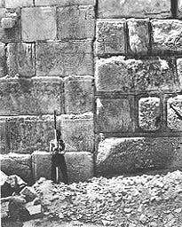
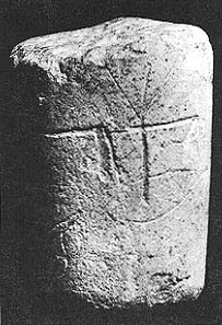
Miss Kenyon believes she has found the point on this east wall of the Temple Mount where Herod began his southern extension. Herod’s extension of the east wall, Miss Kenyon says, begins 105 feet from its southern end, indicating that Herod added about this much to the Temple Mount on the southern side. Miss Kenyon can fix the point on the east wall where the southern addition begins because it is marked by a so-called straight joint or seam in the masonry. Ordinarily we do not find a long, straight, vertical line at the point where blocks in a masonry wall join; instead, the mason varies the point of join in each course, thereby giving the wall greater strength. However, the end of a wall makes a straight vertical line; and an addition to the wall will form a straight, vertical joint. That is what occurs in the lower courses of the eastern wall of the Temple Mount (see illustration). South of this straight joint we see easily recognizable Herodian masonry with narrow, slightly sunk margins and smooth centers beautifully dressed to a flat finish. Thus, reasons Miss Kenyon, the obvious Herodian wall south of the straight joint is Herod’s addition to the Temple Mount.
To the north of the straight joint is an entirely different kind of masonry. Although the stones themselves are large, like the Herodian ashlars to the south, they have heavy irregular bosses with a large, lumpy central area. Miss Kenyon attributes the masonry north of the straight joint to Zerubbabel who was in charge of rebuilding the Temple in about 520 B.C. when Cyrus the Great, King of Persia, permitted the Jews to return to their homeland after the Babylonian exile. Miss Kenyon has found parallels to this masonry in Phoenician walls of the Persian period, and suggests that, as in the case of Solomon, Zerubbabel imported Phoenician masons to perform this work. Israeli scholar Michael Avi-Yonah disagrees. According to him, the masonry north of the straight joint is also Herodian, even though it is finished differently from the masonry south of the seam. According to Professor Avi-Yonah, who died in 1973, there were two phases of Herod’s building project. The second phase involved adding the platform south of the straight joint for the erection of Herod’s “Royal Portico” along the southern end of the Temple Mount. But the area north of the straight joint was built by Herod too, Avi-Yonah argues.
A final disagreement involves the so called Royal Tombs of the Kings of Judah. In 1913–14 and again in 1923–24, Captain Raymond Weill, a French archaeologist and the only Jew to perform excavations in Jerusalem prior to 1967, uncovered several sets of tombs within the very oldest part of Jerusalem, that is, in the Jebusite-Davidic city. Unfortunately these tombs had been robbed of their contents long before Weill found them. Usually, Semitic burials occur only outside the city, but the Bible records that King David and the 12 Judean kings following him were buried within the “City of David.” The usual formula is, “He was buried with his fathers in the City of David” (e.g., 1 Kings 11:43; 15:24; 22:51). Although Weill found no archaeological evidence to date these tombs, the fact that they were within the City of David and of such obviously impressive proportions led Weill and many scholars after him to conclude that here was the royal necropolis of the Kings of Judah. Professor Mazar, for one, is inclined to agree. Miss Kenyon not only disagrees, but argues that these rock cut structures are not even tombs! 010According to Miss Kenyon; these rock cuttings were cisterns rather than tombs. While it may be true, as Miss Kenyon argues, that “they are not like any known tombs of the period”, it is also true that the horizontal tunnel tombs are unlike any known cisterns either. It is hard to understand how they could hold water. Miss Kenyon does not address herself to this problem; perhaps she will deal with it in the future.
Miss Kenyon writes with a notable lack of warmth about the Biblical people of the book. It may be argued she is simply factual reporter of scientific evidence. On the other hand, one wag has suggested that during her excavations at Jericho she developed such sympathy for the people of that ancient city, that she never forgave the Israelites for destroying it.
In any event, she regards the Israelites who captured Jerusalem as “oppressors”, presumably of the Jebusites. “The various ‘oppressors’ [Israel’s enemies]”, she writes, “were now [when Israel captured Jerusalem] oppressed in their turn” (Archaeology in the Holy Land, 3rd ed., New York: Praeger Publishers, 1970, p. 244). Note the subtle use of quotation marks. By referring to Israel’s enemies as “oppressors” in quotation marks, Miss Kenyon implies that they were really not oppressors at all, but that they were subsequently truly oppressed—without quotation marks—by Israel.
Miss Kenyon’s writing often shows little appreciation for early Israel’s spiritual culture. She views early Israel’s civilization as so much stones and mortar, and perhaps some crude pottery. In Archaeology in the Holy Land, she says of the Israelite levels of two typical sites, “There was nothing to suggest any high degree of civilization” (p. 254). The effect would have been softened, if not made more accurate, had she confined herself to “material civilization.”
Miss Kenyon’s objective view of what constitutes “civilization” may be reflected in the fact that she gives Phoenician masons and artisans (beginning in King Solomon’s time) major credit for “the civilizing of Israel” (Archaeology in the Holy Land, p. 244).
Prior to Solomon’s time, Israel was apparently uncivilized. In assessing Israelite culture at the time of the conquest of Jebusite Jerusalem, Miss Kenyon speaks of an “Israelite culture in comparison with which Jebusite Jerusalem was civilised” (Royal Cities of the Old Testament, New York: Schocken 1971, p. 49.)
On occasion, one gets the impression that Miss Kenyon’s negative judgment of Israelite civilization includes the spiritual as well as the material. Thus she writes that “There is little in the record, either literary [!] or archaeological, to suggest that much 011progress towards civilisation was made during David’s reign” (italics added) (Archaeology in the Holy Land, p. 244).
If archaeologists sometimes exaggerate the ancient splendor of sites they excavate, this is surely not true of Miss Kenyon and Jerusalem. For her, the city was not particularly impressive, when it was crowned by King Solomon’s Temple or by the later Temple of Herod the Great. According to Miss Kenyon, “Modern taste might find [Herod’s] temple building, and also that of Solomon, unbearably luxurious and ostentatious” (Digging Up Jerusalem p. 219). This judgment may be compared with a more typical description of Herod’s Temple, this one from Professor Harry Thomas Frank’s recent Discovering The Biblical World (New York: Harper & Row, 1975, p.176): “This monumental sacred complex gleaming in the warm-hued limestone of the Judean hills was surely one of the most magnificent buildings of the Greco-Roman era”.
The most pervasive and persistent difference between Miss Kenyon and Israeli archaeologists concerns the areas of Jerusalem which were settled during the various post-Solomonic periods of the city’s history. Miss Kenyon argues strongly for what might be called the minimalist position: The city remained a small settlement until the first century A.D. The Israelis contend the city expanded to adjacent areas during the period of the Judean monarchy.
The question involves issues of archaeological evidence and historical interpretation. Also intertwined are questions of possible political bias and professional pride. Finally, the Israelis see the matter as raising a question of the validity of Miss Kenyon’s vaunted archaeological method.
To understand the debate, it is important to understand the topography of Jerusalem. The area involved might be imagined as a giant tooth. The present squarish wall of the Old City—built by Suleiman the Magnificent between 1538 and 1541 A.D.—is the cap of the tooth. Hanging beneath this cap are two roots. The one on the right (east) is small and narrow with steep slopes; it is called the Hill of Ophel or the City of David. The one on the left (the western ridge) is higher, flatter, and broader; today it is called Mount Zion. On the right side of this giant tooth extending its entire length is a steep valley known as Kidron. On the left of the tooth is the Hinnom Valley which then curves around to the south of Mount Zion to join the Kidron. Between the two roots—more accurately, ridges or spurs—is another valley called the Tyropoean. The Tyropoean Valley, especially at its northern end, has been much filled in. In ancient times this valley extended up into the cap of the tooth.
One of the major accomplishments of Jerusalem archaeology during the last century has been to establish that the original city of Jerusalem was located on the small eastern ridge known as Ophel. Although the western ridge (Mount Zion) is in most respects a far more suitable site, it does not have a defensible water supply, like the eastern ridge. Such a water supply was often critical in siege defense, which is why whoever first built Jerusalem did so on the eastern ridge.
Perhaps the most brilliant of her many accomplishments in seven seasons of excavations in Jerusalem has been Miss 012Kenyon’s clarification of the defenses of this spring on the eastern side of the eastern-ridge. She has also established to the satisfaction of almost all scholars that this city, limited to some 11 acres, stopped on the north considerably before the area of the present walled city and Temple Mount. This was the Jerusalem of the Jebusites and King David. King Solomon extended the city to the north. He built the Temple on a platform in the area of the present Temple Mount, and connected the new Temple area with the old Davidic city by walls on the east and west. So much is generally agreed upon.
In the course of her excavations, Miss Kenyon also opened up a number of 5-meter squares on the eastern slopes of the western ridge (Mount Zion) in which she found remains going back only to the first century A.D. On the northern part of the western ridge earlier soundings had found evidence of occupation beginning only in Maccabean times. This convinced Miss Kenyon that Jerusalem did not expand across the Tyropoean Valley onto the western ridge until Maccabean times (on the northern part of the ridge) and Herod Agrippa’s reign (on the southern part of the ridge). The Israelis were just as convinced that the city had expanded to the western ridge during First Temple days. When the present Old City and the Hill of Ophel became part of Israel in 1967, the Israelis took every opportunity to gather the archaeological evidence.
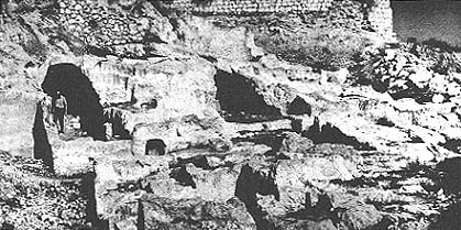
In 1970, Professor Nachman Avigad of Hebrew University, one of the most meticulous of Israeli excavators, discovered a massive wall in the Jewish quarter of the Old City, a part of the city which had been largely destroyed during the period of Jordanian control. (Ironically enough, it was this fact that permitted Avigad’s excavation). This wall—23 feet thick in some places—was located opposite the Temple Mount on the western ridge, which Kenyon had argued was not settled until Maccabean times. Avigad dated his wall to the late eighth century B.C. and suggests that King Hezekiah is the probable builder of the wall. Miss Kenyon, in her recent book, accepts Avigad’s dating of the wall and this has required her to alter drastically her map of Jerusalem during the Judean monarchy. In her 1967 book on Jerusalem, Miss Kenyon drew the borders of Jerusalem during the later monarchy like this (p. 57);
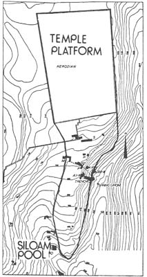
But in her 1974 book she has changed the map to look like this:
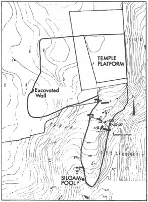
013But even this is a far cry from Professor Avigad’s map. While Miss Kenyon cuts off the expansion of the city during the period of the Judean monarchy at almost the present south wall of the Old City, Avigad extends it to the southern end of the western ridge:
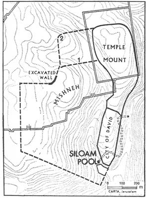
Among other things, Avigad’s map has the advantage of placing the Pool of Siloam within the city walls. The Pool of Siloam lies at the end of a serpentine tunnel dug by King Hezekiah in about 701 B.C. in order to bring into the city the waters of the spring which served Jerusalem. Hezekiah’s purpose in building this tunnel was to provide water to the city during the siege of Sennacherib and to deny it to the Assyrians, all as described in the Bible (2 Kings 18:13–19:35 and 2 Chron. 32). Very likely this water tunnel, which tourists can still walk through today, enabled the city successfully to withstand the Assyrian siege. Yet if Miss Kenyon is correct, Hezekiah’s tunnel carried the water from one point outside the city walls to another point also outside the city walls. This is especially difficult to understand because Hezekiah chose the spot where the tunnel ended; two crews of tunnelers dug the tunnel, starting at either end and meeting in the middle. That is one reason why Professor Avigad believes the wall he uncovered extended further south enclosing Mount Zion and the Pool of Siloam.
Miss Kenyon’s answer to this is that it was not necessary to enclose the Pool of Siloam within the city walls, because the Pool, although outside the city, was camouflaged; that is, it was not a pool, but a rock cut cistern covered over so as to avoid Assyrian detection, but accessible from within the city by another underground shaft and tunnel. However, if this was in fact the case, no trace of this shaft and tunnel, or of the cistern, remains. Miss Kenyon believes that this was nevertheless necessarily the case, although she “can produce no archaeological evidence to prove this interpretation” (p. 159). While few Israeli archaeologists have accepted her interpretation, Miss Kenyon reports that “I have convinced most of my colleagues whose opinion I respect” (p.159).
While Miss Kenyon is, as a result of Avigad’s excavations, “very prepared to accept that there was some expansion from the eastern ridge onto the western ridge at its northern end (italics in original) (p.160), she remains firmly convinced that this expansion of the city did not extend further south onto what is known today as Mount Zion until after Jesus’ time. This conclusion, she says “has recently been confirmed by Israeli excavations outside the [Old City] walls, immediately to the south [on Mount Zion]. One can say very firmly that the present evidence is that on the summit of the western ridge there was no occupation within the period of the Monarchy of Judah” (pp. 147–8).
The Israeli excavations to which Miss Kenyon has reference were conducted on Mount Zion by Archaeologist Magen Broshi. In an article on this excavation in Jerusalem Revealed, he reports that “in every spot where we approached bedrock, typical Israelite remains were found…indicating that this location was settled already in the 7th century B.C.E.… We encountered few actual building remains from this period, including one house”.
021It is difficult to understand how Miss Kenyon can cite these excavations to confirm her view that Mount Zion was not settled during the period of the Judean Monarchy when they established just the contrary. It is equally difficult to predict how Miss Kenyon will treat this evidence when she confronts it.
Interestingly enough, in Miss Kenyon’s first popular book on Jerusalem she showed Mount Zion outside the city even in the Maccabean period. In her recent book, she has included Mount Zion within the city, not on any new archaeological evidence, but because “it is virtually certain on strategic grounds that by the Maccabean period a considerable part of the crest of the western wall [sic; ridge?] must have been defended” (p.200).
But even during the Maccabean period, Miss Kenyon excludes the central Tyropoean Valley from her map of the city—in deference to the fact that on the eastern slopes of the western ridge she was able to find no evidence of occupation until after the time of Jesus. Thus, Miss Kenyon’s plan of Maccabean Jerusalem takes a strange shape indeed, which excludes the central Tyropoean Valley. It is perhaps worthwhile to sound a note of caution about the dangers of drawing too firm conclusions on the basis of such small areas of excavations, even when they are excavated by the most careful stratigraphic techniques. (See “‘Digging Up Jerusalem’—A Critique,” in this issue.)
Whether it is an anti-Zionist bias that has continually led Miss Kenyon to underestimate the expansion of Jerusalem will never be known. Nor can we plumb the questions of professional pride, as Miss Kenyon continues to expand her maps of Jerusalem in light of Israeli excavations and her own second thoughts.
What is not in doubt is that Kathleen Kenyon is virulently anti-Zionist. The more subtle question is whether this affects her work as an archaeologist. It is not hard to find Israelis who think it does. Others suggest it is only a professional cantankerousness that so often sets her against Israeli archaeologists. In any event, important questions of archaeology and history are at stake. Several years ago, a rumor circulating among Israeli archaeologists had it that Miss Kenyon had written an article entitled “From Jericho to Deir Yassin”. When the walls of ancient Jericho came tumbling down, the Israelites […]
You have already read your free article for this month. Please join the BAS Library or become an All Access member of BAS to gain full access to this article and so much more.
Already a library member? Log in here.
Institution user? Log in with your IP address or Username
Footnotes
A section drawing is a vertical drawing identifying the various layers or strata, which can be extremely complicated. A section drawing is contrasted to a plan, which is a ground drawing—a view from above looking down.