
Aḥwat, El-
THE SITE
The ancient site at
EXCAVATION RESULTS
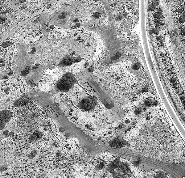
The site is c. 7.5 a. in area and is surrounded by a system of fortifications including the settlement wall, towers, and gates. In addition to these, there is an internal division into fortified quarters.
THE SETTLEMENT WALL. The total length of the settlement wall is c. 600 m. and its width varies between 5 and 8 m. The plan of the walled site resembles a boat, its long axis oriented north–south with its narrow side (the “bow”) to the north. The settlement wall follows a meandering course without apparent topographical justification. It consists of two walls of large fieldstones, each c. 2 m wide, with a fill between them. Several sections excavated along inner and outer faces of the wall indicate that it was founded upon bedrock. The wall is generally well preserved, although modern road construction destroyed part of it in the southeast of the site. It appears to have been erected during the first phase of the site’s foundation, as the buildings within it follow its contours. Along the wall were found several offsets, which are referred to here as “towers.” These are not, in fact, true towers, but part of the unique design of the settlement wall. The only true tower is T53, located in the wall’s eastern part. Next to it there appears to have been another entrance to the site.
THE ENTRANCE GATE. The wall’s northern gate, of relatively simple construction, is 4.5 m wide. A row of threshold stones and a door socket are preserved. To its outside is an enclosed triangular entrance plaza, 45 sq m in area, with remains of an outer entrance. This plaza differs from those associated with city gates at other Bronze and Iron Age tell sites in that it slopes downward toward the gate rather than ascending to it.
THE FORTIFIED QUARTERS. The division into four quarters with possible functional differentiation is another uncommon feature. The northern quarter, areas A–B, is associated with the settlement gate and the “governor’s house”; most of the domestic dwellings were found in the western quarter, area C; the eastern quarter, area D, probably contained domestic dwellings and craft and industrial structures; little is known about the southern quarter, area E.
The thickness of the walls of the quarters is c. 2 m. Between quarters A–B and D are large stone structures in the form of mounds, which are incorporated into the quarter walls. The quarter wall between quarters C and D is likewise complex. The quarter walls were bonded to the settlement wall. Construction within the quarters followed the erecting of these walls.
INTERIOR STRUCTURES. Area C, 60 percent of which has been excavated, provides a clear picture of the dwellings at the site. The construction is simple: relatively thin walls and earthen floors overlying a stone bed. Floors and walls rest upon bedrock. Some of the characteristics of Iron Age I hill-region culture are absent here: no segmented columns are used in construction, there are no rock-cut cisterns, and built silos are absent. Similar domestic architecture occurs in area D. Another unique feature of the site is building plan: in area C, a group of buildings of a type unknown in Israel was encountered, including a very large structure with two rows of rooms and a corridor running between them, and various installations. The entire complex follows the contours of the settlement wall and was clearly constructed together with or slightly after it. An alleyway leads to the settlement wall, its two flanking walls running perpendicular to it. It may be assumed that this was a point of access to the settlement wall, which could have been reached via a ladder from here.
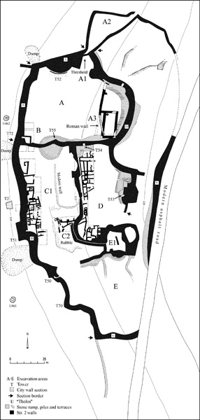
A single structure of the three-room house type, similar to those of the Iron I hill-region culture, was found in area D. Several storage facilities were excavated nearby, and next to them was found an iron smelting furnace. Discovered in the south of the excavation area was a circular plaza containing buildings.
THE IRON SMELTING FURNACE. The furnace was covered with a dome constructed of small stones. In front of it is a room, on the floor of which iron ore was found. It appears to be a workroom where iron ingots were forged and raw materials were stored. The source of the raw material was meteorite iron or locally obtained ores. This smelting furnace is stratigraphically associated with the rest of the buildings of area D; its dating is thus clear. This is the oldest smelting furnace of its type found to date in the southern Levant.
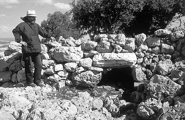
UNUSUAL ARCHITECTURAL FEATURES. In addition to the characteristics noted, two other types of buildings were encountered that are absent at other contemporary sites. One type consists of four corridors constructed within the settlement wall. They are 3–4 m long, less than 1 m wide, roofed with stone slabs, and varying in height. Each of these corridors led to occupational surfaces of the site and were as high as the bottom third of the settlement wall. Three corridors are straight; one is elliptical with a round room roofed by a “false dome” system at its end. Similar corridors have not been found in any contemporary settlement walls.
The second type of structure resembles a circular tholos, constructed of stone and also roofed with a “false dome.” Several such tholoi were found outside the site and one within the site, connected to the settlement wall and to tower T53. Circular tholoi are well known from the Roman-Byzantine period, when they were utilized for storing agricultural products. However the occurrence of such structures at the beginning of the Iron Age appears to be unique.
POTTERY AND SMALL FINDS. Sherds from the excavation present an interesting picture. The pottery types belong to two groups: the Iron Age I hill-country wares and vessels of the contemporary lowland culture, with parallels at nearby
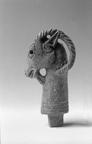
The small finds include ten Egyptian-type scarabs, eight of which belong to the Nineteenth Dynasty. One of these is early (Middle Bronze Age II) and one—a scarab bearing the name of Ramses III—slightly later. A variety of patterns appear on these scarabs: Egyptian goddesses, crocodiles, plants, and other Egyptian motifs. The cylinder seal, which bears a mythological scene, is of Anatolian-Ugaritic type and dates from the mid-thirteenth century BCE. Also noteworthy are a bronze head, perhaps of a goddess of a northern type, a black stone seal depicting a soldier on one side and a horse on the other, and an ivory carving of the head of a horned ibex that served as a decoration for a luxury object. This latter find is probably related to various ceremonies of the Egyptian court of the Eighteenth to Twentieth Dynasties, where similar luxury objects with animal heads occur. Over 100 beads and jewelry found at the site fit into the same tradition and have parallels in the cemetery of
STRATIGRAPHY AND CHRONOLOGY
The settlement at
Stratigraphically speaking, the entire settlement consists of a single layer, stratum 2. The construction of buildings in relation to the settlement and quarter walls, which they abut, suggests that the settlement and quarter walls were constructed first. The settlement thus appears to have been planned first as a fortified citadel and was settled only subsequently. This settlement within the wall was never completed, as a large part of the site was not settled at all and remained empty.
The dating of stratum 2 is based upon the pottery and wealth of glyptic finds. Unlike other small and short-lived settlements,
After nearly a 1,600-year hiatus, settlement resumed during the Late Roman period (stratum 1). From the fourth century CE, the site became an area of agricultural activity. The inhabitants cleared some of the building stones that covered the site and placed them in large piles and along the lines of the settlement and quarter walls. During this phase, only the floors and the lower courses of walls were left; these were covered by a layer of agricultural soil, containing sherds and a few coins of the fourth century BCE, brought from a Roman period site elsewhere. No Roman architectural remains were found in stratum 1 (with the exception of a small retaining wall in area A3). There was clearly no settlement here, only agricultural activity.
CONCLUSIONS
The composite characteristics of
In searching for the origins of the unique phenomena at this site, the excavator has proposed a link to the Bronze Age cultures of the western Mediterranean, in particular Sardinia, Corsica, and the Balearic islands. The Shardana tribe of the northern Sea Peoples is known from Egyptian literary sources (Papyrus Harris A, Wen-Amon Papyrus, and the Onomasticon of Amenope) to have settled in this region. It has been suggested by the excavator that the settlement at
ADAM ZERTAL
THE SITE
The ancient site at
EXCAVATION RESULTS
The site is c. 7.5 a. in area and is surrounded by a system of fortifications including the settlement wall, towers, and gates. In addition to these, there is an internal division into fortified quarters.