Abu Hawam, Tell
1553
THE SITE
Tell Abu Hawam, a site on the estuary of the Qishon River north of the Carmel Ridge, within the municipality of Haifa, has aided archaeologists in the quest for knowledge of contacts and trade relations in the ancient world, especially between the Aegean and the Levant. Its auspicious location is midway between Cyprus and the Nile Delta, where maritime and terrestrial routes met, and at the foot of the Carmel Ridge, which protects it from the prevalent southwesterly winds and enhances its usage as a harbor. The drawbacks of the site include its position on an active geological fault line, the swamps of the Qishon River, and the proximity of the Carmel Ridge, which hampered the continuation of the terrestrial trade route. The site is now located c. 1.5 km from the coast due to geomorphologic changes, silting caused by the Qishon River, and industrial and urban development that changed the river’s course and dried the area.
RENEWED EXCAVATIONS
In 2001 and 2002 salvage excavations were carried out by the Recanati Institute for Maritime Studies at the University of Haifa and the Israel Antiquities Authority, under the direction of M. Artzy with the assistance of S. Yankelevitch and U. Ad. The data from the renewed excavations can greatly contribute to our understanding of the geographical and ecological setting of the site. The project included a geomorphologic study by E. Reinhardt and B. Goodman from MacMaster University in Canada.
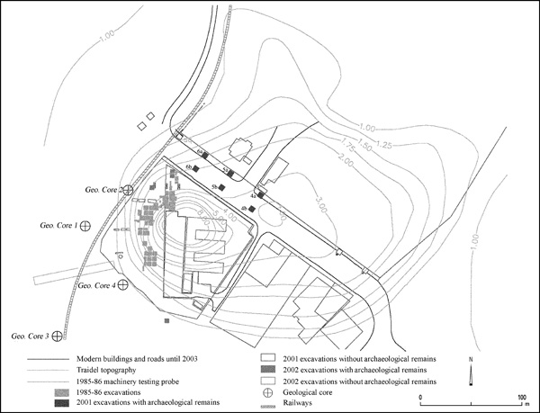
In the 2001 season the excavated area was located on the northeastern side of the site, an area not previously investigated. This is thought to have been the “lower city” proposed by J. Balensi, following the map compiled in the 1920s by J. Traidel. An attempt was made to prepare the new maps in accordance with those of the Balensi expedition of 1985–1986. Six 5-by-5-m squares were excavated. Although some of the squares were empty of archaeological finds, the data is important for understanding the paleoenvironment. In order to facilitate the archaeological work and enable excavation below sea level, a number of 5-by-5-m metal caissons were constructed and placed, when possible, at a depth of c. 3 m below sea level. The few architectural remains originate from two distinct strata: stratum II—the Persian period, and stratum V—the Late Bronze Age, according to R. W. Hamilton. No remains from intermediate periods were discerned. The distinction between the layers was based on changes in soil composition attributable to river flooding, sand silting, and human intervention. The 2002 salvage excavation, a more limited project, consisted of trial trenches on the southwestern side of the site, in which no archaeological remains were found, and on the western side of the site, where again stratum V was superseded by the remains of stratum II of the Persian period.

Despite the lack of clear architectural remains in the 2001 season, there were unusually large ceramic assemblages as well as numerous faunal remains, including crushed murex shells, waste from a purple dye industry. Many of the ceramic wares are imports. It is likely that a good percentage of the sherds were refuse or damaged wares thrown from the boats during or following their arrival. It should be emphasized that very few sherds show any signs of water wear, probably because they landed in silt. Dating of the site is necessarily based on the ceramics, which were sealed by the geological strata. The pottery from the earliest stratum can be dated to the end of the fifteenth century BCE, probably post-Tuthmosis III or even later. The majority fits well within the fourteenth century and the first half of the thirteenth century BCE. The anchorage ceased to exist at the end of this period, whether for geopolitical or geomorphologic reasons. This stratum is equivalent to Hamilton’s stratum V. No remains could be attributed to his stratum IVb, nor were there any traces of Balensi’s strata VI (Middle Bronze Age IIB and Late Bronze Age IA) or Vc. Subsequent human activity is attributed to level II of Hamilton and Balensi, the Persian period.

1554
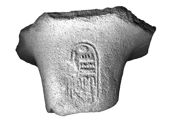
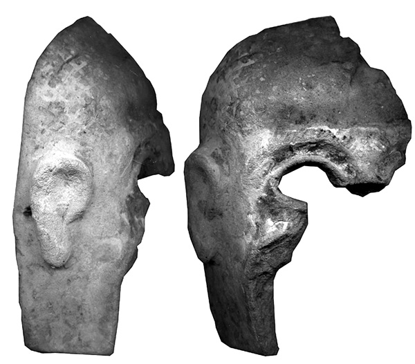
Among the imported vessels are Mycenean IIIA2, Minoan, and Anatolian gray and tan wares. Not surprisingly, Cypriot imports are by far the majority of the foreign wares. They include a few samples of base ring I and numerous examples of base ring II, white slip II, monochrome, white shaved juglets, and red-and-white lustrous pieces. There are also wall brackets and numerous diagnostic sherds of pithoi of possible Cypriot origin, a common component of ships’ cargos. Other ceramic forms might well belong to the plain white wheel-made ware of Late Bronze Age Cyprus. A storage-jar handle bearing the cartouche of Ramses II is one of a handful of Egyptian wares. Among the finds whose origins are as yet uncertain are a mask and a group of mostly handmade, black-gray and reddish sherds belonging mainly to small kraters or even cookware. The variety of cookware is astonishing, and indicates the varied origins of the ships frequenting the international entrepot of Tell Abu Hawam.
| Stratum | Period | Date BCE |
|---|---|---|
| Stratum I | Surface material | |
| Stratum II | Greco-Persian | Late 6th–early 4th centuries |
| Stratum III | Iron Age II | 1100–925 (?) |
| Stratum IVb | Iron Age I | 1195–1190 |
| Stratum IVa | Late Bronze–Iron I | 1230–1195 |
| Stratum V | Late Bronze Age | 1400–1230 |
| Stratum | Period | Desciption | Centuries BCE |
|---|---|---|---|
| Stratum I | Medieval, Byzantine, Roman, Hellenistic | Surface, mixed debris | |
| Stratum IIb | Late Persian–Early Hellenistic | Fortified city | Late 4th |
| Stratum IIa | Persian | Regional granary | 5th–4th |
| Assyrian, Babylonian | Gap | 7th–6th | |
| Stratum IIIb | Iron Age II(A) B–C | Renewed planning | 10th–late 8th |
| Stratum IIIa | Iron Age IIA | Fortified city | 10th |
| Stratum IVb | Iron Age I/IIA | Public buildings | 11th–10th |
| Stratum IVa | Iron Age IB | Three-room houses | 11th |
| Stratum Vc | Late Bronze Age IIB/Iron Age IA | New settlement | 13th–12th |
| Stratum Vb | Late Bronze Age (IB)/IIA–B | Cyclopean fortifications | mid-15th |
| Stratum Va | Late Bronze Age IB | Quarry and terracing | 15th |
| Stratum VI | Middle Bronze Age II, Late Bronze Age IA | Maritime trade | 16th–15th |
CONCLUSIONS

The finds from the 2001 excavations could not substantiate the existence of a Late Bronze Age lower city in the northeastern area of the tell, as had been previously suggested by Balensi based upon the contours of the Traidel map, thus reducing the estimated size of the Late Bronze Age settlement. This part of the site was most likely covered by water and served as an anchorage during that period. The date of the original settlement, using the new data, should be placed in the late fifteenth century BCE or slightly later. Since the archaeological remains uncovered in the 2001–2002 excavations are attributed to strata V or II, the Iron Age site must have been even smaller than that of the Late Bronze Age, at least on its western and northeastern sides. Ecological changes likely took place in historical periods, influencing the settlement patterns and periods of occupation.
MICHAL ARTZY
1553
THE SITE
Tell Abu Hawam, a site on the estuary of the Qishon River north of the Carmel Ridge, within the municipality of Haifa, has aided archaeologists in the quest for knowledge of contacts and trade relations in the ancient world, especially between the Aegean and the Levant. Its auspicious location is midway between Cyprus and the Nile Delta, where maritime and terrestrial routes met, and at the foot of the Carmel Ridge, which protects it from the prevalent southwesterly winds and enhances its usage as a harbor. The drawbacks of the site include its position on an active geological fault line, the swamps of the Qishon River, and the proximity of the Carmel Ridge, which hampered the continuation of the terrestrial trade route. The site is now located c. 1.5 km from the coast due to geomorphologic changes, silting caused by the Qishon River, and industrial and urban development that changed the river’s course and dried the area.
