
Apollonia-Arsuf
RENEWED EXCAVATIONS
From 1990 to 2004, 11 excavation seasons were conducted at Apollonia-Arsuf (
In 1996, excavations were conducted in the area of the now dismantled Israel Military Industries Nof Yam plant. An excavation area was opened at the center of the eastern city wall (area J, below), under the direction of H. Yohanan. A city gate and the moat in front of it were uncovered and two Crusader period building phases were encountered. Another area was opened in the area of the Byzantine church (area K). Fragmentary foundations were found in its eastern portion and a vaulted and well-plastered pool, preserved in its entirety, was found beneath the floor of the atrium. Beneath the foundation level of the church was found a layer of dark sand containing considerable amounts of Chalcolithic pottery and flint implements. In the area that extends east of the city wall for up to 400 m, 28 trenches were excavated to virgin soil. While most of these trenches did not yield archaeological finds, four Late Roman tombs were found c. 180 m east of the city gate. These mark the eastern extent of the Byzantine city and allow us to estimate its total area as 70 a.
From 1998 to 2000, excavations were conducted in the southern part of the city (area E) by the Department of Classical Studies at Tel Aviv University and the Universidade Federal do Rio Grande do Sul in Porto Alegre, Brazil, under the direction of F. Marshall. The Byzantine levels south of the city wall were excavated and a Roman villa with a peristyle courtyard was exposed below them. Large-scale excavations were also carried out during those years with the aim of developing the site as an archaeological park. They exposed the architectural elements of the Crusader fortress (area F, below), with some 21,000 cu m of deposits manually cleared from the built area of the fortress and some 15,000 cu m cleared by mechanical means from the moat surrounding it.
Early in 2002, the last large-scale excavations were conducted in the Crusader fortress (area F), focusing primarily upon the space east and south of the fortress gate between the main fortifications and their outer walls. This entire area was completely destroyed by the Mamelukes to below floor level. Thus, finds pertaining to the actual entrance to the fortress were not encountered. During the same year, excavation in the southern part of the site (area E) exposed more of a row of the Early Islamic rooms abutting the city wall from within. This revealed that the Islamic city wall was erected above a Byzantine water storage system utilized by contemporary sauce and fish salting operations in the area to the south. The finds from the earliest floors associated with the city wall provided further evidence for the construction of the fortification during the rule of ‘Abd al-Malik (685–705 CE). The rooms abutting the wall were restored during the Crusader period and served first as dwellings, then later as craft workshops and a drainage area. Finally, toward the Mameluke siege, the walls of the rooms were leveled and the space between them was filled with earth and stones, up to the height of the tops of the truncated walls. A thick plaster floor abutting the fortification wall was laid over the entire area. Thus, a firm inner rampart was added to the fortifications, which also provided direct access to the wall for the first time. This did not prevent the site’s conquest and destruction by the Mamelukes, signs of which were abundant in the upper layer throughout the area.
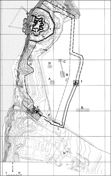
In 2003 and 2004, excavation was renewed in the southern part of the city, in a new area extending east of the Byzantine installations (area P). At the bottom of the excavation in the north of the area were found 2.70-m-wide foundations constructed of fieldstones held together with mortar, penetrating deep into a Byzantine
EXCAVATION RESULTS
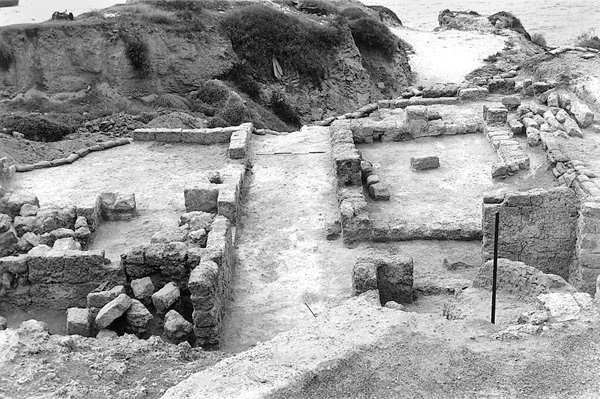
THE ROMAN VILLA. The only Roman architectural complex excavated at Apollonia to date is a peristyle villa constructed upon an almost square surface cut into the top of a kurkar cliff overlooking the sea in the southern part of the site (area E). The villa, built of kurkar stones bonded with cement, was oriented to the four cardinal directions. Its peristyle courtyard is surrounded by square pilasters. A long corridor crosses the entire complex from west to east and is flanked by rooms with plastered floors and walls on both sides. At the eastern end of the corridor, two plastered niches recall domestic cultic corners (lararia), typical of dwellings in Roman Italy. The villa afforded its residents maximum comfort and privacy, combined with a sea view. This villa maritima would appear to have been the residence of a family of high socio-economic status. All the evidence suggests a Western-type structure, apparently erected by a businessman from the West or by a wealthy Romanized local. The paucity of finds from the initial phase of the villa, dated to the end of the first century CE, indicates that it may never have been completed. At the beginning of the second century CE, parts of the building were turned into storerooms; these were destroyed and entirely covered by collapse resulting from an earthquake during the second or third decade of that century. Since the ground here was lower than its surroundings, it became a garbage pit in which large quantities of second–third-century CE Roman pottery were thrown. Contemporary written sources indicate that Apollonia was a significant coastal town during the Roman period.
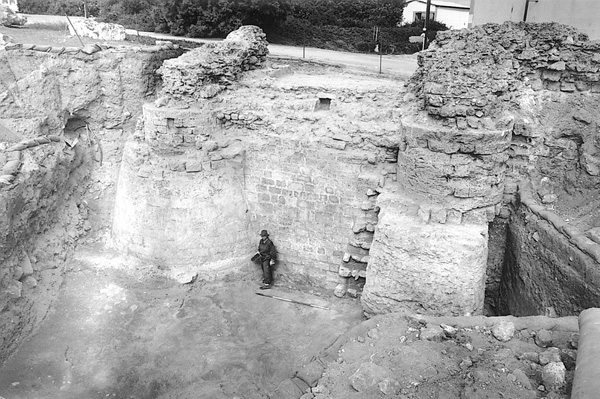
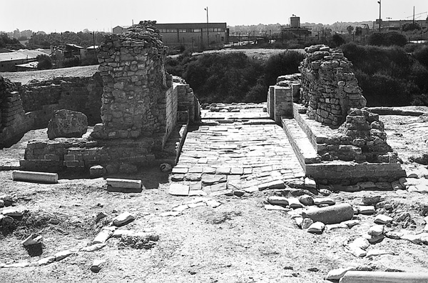
THE CRUSADER CITY GATE. The excavations revealed two construction phases of the eastern city gate (area J). The pottery assemblages associated with both phases are dated to the Crusader period.
The early gate included two semi-circular outward-projecting towers, 2.10 m apart, narrowing upward from the base. The diameter at the base of each tower is 4.40. Between the towers is a wall that served as the foundation for the threshold of the gate entrance, which was not preserved. In the upper portion of the connecting wall are two stones forming the base of an arch that opened to the east and apparently supported a wooden drawbridge. The towers were constructed with a massive core built of fieldstone bonded with mortar and an outer face of kurkar ashlars. To the east of the towers is a moat 9 m wide, opposite which is a retaining wall preserved to a height of over 2 m. The parts of the towers uncovered appear to have been the foundations for a gate structure that included at least one upper story, perhaps two, as based upon Western European parallels.
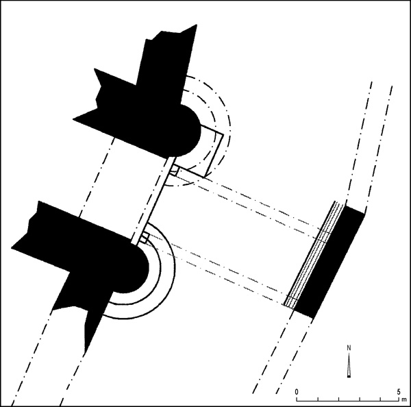
The later gate is slightly different than its predecessor. The bottom part of the southern semi-circular tower remained unchanged, but a massive rectangular pier was constructed upon it, semicircular on its eastern side, like the tower itself. The northern tower was entirely dismantled and replaced by a rectangular cast foundation of mortar and fieldstone. This was intended to support a semicircular ashlar pier of similar size and shape to the southern pier. The space between the two piers, 4.40 m, was filled with mortar and fieldstone and the upper surface became the threshold of the later gate. Beneath it was a drainage channel, lined with kurkar slabs, which drained waste water out of the city. The piers on both sides bear remnants of what appears to have been a vaulted roof over the gate. Access to the gate from the east during the second phase was not via a drawbridge as during the first phase, but along a rampart built of several layers of fill that completely blocked the original moat.
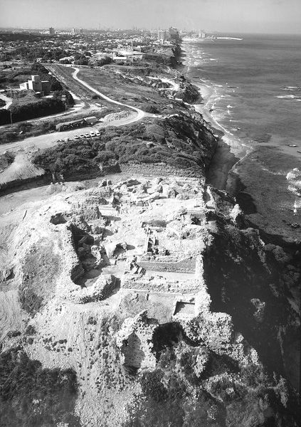
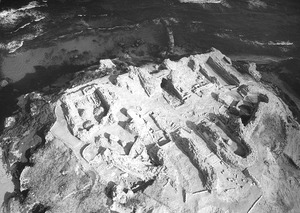
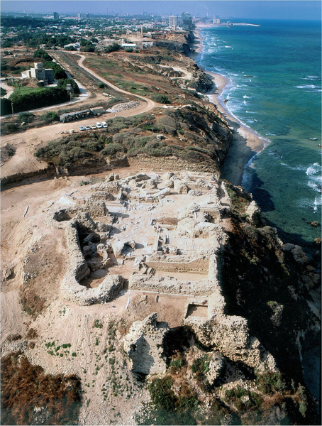
THE CRUSADER FORTRESS. The Crusader fortress (area F) is the most important Crusader period architectural complex at Arsuf. It is a concentric, multi-component complex located in the northwestern part of the fortified city and including the following elements, described from the inside outward: (1) A central, irregular courtyard surrounded by broad halls. (2) The main pentagonal fortification including a gate in the east protected by two semi-circular towers, with an additional semi-circular tower on each side, and a donjon and two square corner towers in the west. (3) An external fortification with an outline largely corresponding to that of the main fortification, but at a lower elevation and with a wider opening. (4) A broad, deep moat bounded by an outer retaining wall. (5) A system of vaulted halls and retaining walls along the cliff at the western façade of the fortress, which largely collapsed, falling to the base of the cliff. (6) A port facility, of which the foundations of two side breakwaters (northern and southern) have been preserved.
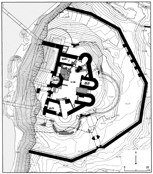
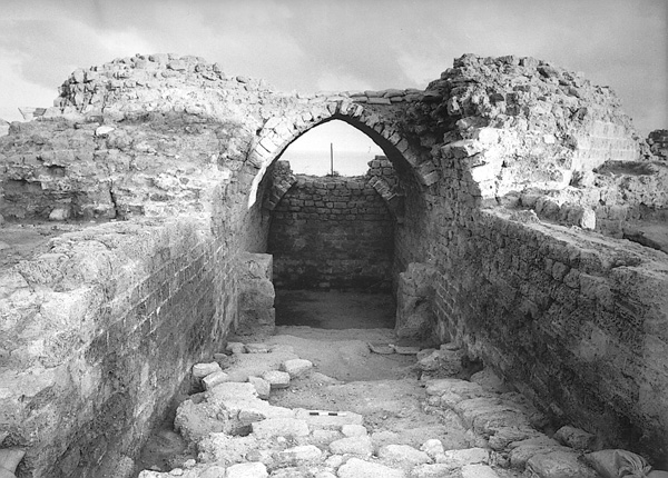
The Gate. The main element in the eastern wing of the main fortification is the gate. This is a massive structure that apparently was originally multi-storied. The walls of the ground floor have been preserved throughout and the floors have been preserved in their original form. The gate consists of two apsidal halls facing east, which, from the outside, appear as two semi-circular towers narrowing upward from the base; and the paved passage between them, originally equipped with means of closure.
The inner measurements of the northern apsidal hall are 11.90 by 4.60 m. The core of its walls has been preserved to a considerable height—the southern wall to a height of 4.30 m above the floor. The kurkar ashlar face, on the other hand, with its mortar carefully smoothed at the joints and its layer of fine white plaster, is preserved to a maximum height of only 1.5 m. There are also remains of iron hooks in the wall, to which wooden furniture or tapestries were apparently attached. In the western wall is an entry with a well-preserved threshold of stone slabs; it once had a door that opened inward. Nothing has survived of the ceiling of the room, however several arch stones found in the collapse allow us to assume that it was vaulted.
The preservation of the southern hall is considerably poorer than that of its northern counterpart. Most of the apsidal portion at the eastern edge has been destroyed, and bears signs of a conflagration. Apparently it was one of the points through which the Mameluke forces penetrated the fortress. The interior of the southern hall is of similar shape and size to the northern hall, except for the entrance, which is located at the northern edge of the western wall rather than in its center. The remains found within the hall, however, indicate that at some point its function was quite different from that of the northern hall. It was divided into five rectangular installations, only the plaster floors of which have been preserved, each with a round drain stone. The walls dividing the installations appear to have been intentionally removed during the final phase of the hall, probably in recreating the single long hall initially intended here. The shape and drain stones of the installations are very similar to laundry facilities known elsewhere in the country.
The gate itself is located between the two apsidal halls, its lower portions having been entirely preserved. It includes a threshold built of kurkar slabs at its center, bounded by elaborate Roman and Byzantine period architectural elements used secondarily for reinforcement: to the east, a granite pillar lying horizontally; and to the west, a marble column lying horizontally that served as a step. At the edge of the marble column, two hinge sockets were cut for the metal hinges of the gate’s two door panels. There are two flat piers on either side of the eastern side of the threshold that narrow the passageway somewhat to 3.10 m, each with a 15-cm-wide vertical groove used for the raising and lowering of the portcullis. West of the threshold is a well-preserved stone floor of carefully cut rectangular kurkar slabs. Here, the interior of the gate widens to 3.85 m, with a stone bench against the wall on each side. The ceiling above the gate passageway did not survive, however it is assumed to have been vaulted, similar to that of the northern apsidal hall.
The Donjon. The donjon is the most important architectural element in the western wing of the fortress. It is located at the center of the western wall and protrudes from it and inward towards the gate opposite it. Even though only its lower story has been preserved, its form and the thickness of its walls, up to 3.40 m, attest to its importance. The lower story, in the original phase, had a polygonal outer form with a straight wall on the west from which a pentagonal tower emerged. At a later phase, external reinforcement in the form of a talus was added to the two inner corners and the structure was given a squared shape, rendering the lower story of the donjon into a rectangular hall, 6.50 m wide, with a floor sloping down toward the west. This floor consists of rough mortar mixed with stones and appears to have been the main passage between the courtyard of the fortress and the structural elements of its western wing and the port below. The ceiling of the hall consisted of a graduated series of vaults, one of which was partially preserved to its full height, serving as the basis for the recent reconstruction of two additional vaults. Of the story above, only the lower edge of the walls and a portion of the plaster floor remain. The outline of this second-story floor was polygonal, parallel to that of the ground floor.
The first story could be entered from an opening in the northern wall, of which only the threshold has been preserved. However, the main entrance appears to have been south of the donjon, where a monumental staircase rises from the courtyard to the west toward a wide, well-paved surface. From that surface there was apparently another staircase alighting toward the entrance to the tower, though neither the staircase nor the entrance has been preserved. In view of Western European parallels, there would appear to have been two or three other stories above the 4-m-high ground floor, indicating that the donjon rose to a height of 12 m and perhaps 16 m above the graduated vault. Based upon European parallels, the donjon generally served as the residential quarters of the master of the fortress, his family, and the closest members of his entourage.
ISRAEL ROLL
Color Plates
RENEWED EXCAVATIONS
From 1990 to 2004, 11 excavation seasons were conducted at Apollonia-Arsuf (
In 1996, excavations were conducted in the area of the now dismantled Israel Military Industries Nof Yam plant. An excavation area was opened at the center of the eastern city wall (area J, below), under the direction of H. Yohanan. A city gate and the moat in front of it were uncovered and two Crusader period building phases were encountered. Another area was opened in the area of the Byzantine church (area K). Fragmentary foundations were found in its eastern portion and a vaulted and well-plastered pool, preserved in its entirety, was found beneath the floor of the atrium. Beneath the foundation level of the church was found a layer of dark sand containing considerable amounts of Chalcolithic pottery and flint implements. In the area that extends east of the city wall for up to 400 m, 28 trenches were excavated to virgin soil. While most of these trenches did not yield archaeological finds, four Late Roman tombs were found c. 180 m east of the city gate. These mark the eastern extent of the Byzantine city and allow us to estimate its total area as 70 a.