
Aristobulia, Khirbet
THE SITE
Khirbet Aristobulia extends across the southern and western slope of a hill, 850 m above sea level, about 5 km southeast of Tel Ziph, in the southeastern area of the Hebron Hills. Among the ruins are the remains of buildings, hewn caves, agricultural installations, and water cisterns. The entire site has suffered from pillage and major destruction from later building and agricultural activity. At the northern edge of the ruin, past the dwellings on the crest of the hill, a Byzantine church with a mosaic floor was uncovered.
EXPLORATION AND EXCAVATIONS
The site was mentioned in the nineteenth century by V. Guérin and in the PEF survey. In 1918, A. E. Mader published the site as “The Monastery of Euthymius at Aristobulias,” as part of his comprehensive study of the churches of southern Judea, identifying the site with the monastery that Euthymius built near the village of Aristobulias. Mader described a basilica church at the summit of the site, with a series of rooms to the south of the church. In his view, this was a communal monastery or coenobium, whose monks lived mainly in the surrounding caves rather than within the confines of the monastery itself.
Based upon the historical account of Cyril of Scythopolis, Mader dated the construction of the church to 424 CE. The site was surveyed several times in the 1930s by D. C. Baramki and S. A. S. Husseini, and in 1938, A. M. Schneider published a plan and description of the church, challenging Mader’s dating. On the basis of its architecture, he dated the church to a later period, pointing to similar seventh-century construction. Further surveys at the site were carried out by B. Bagatti and M. Kochavi. In 2000, the church was excavated by Y. Peleg and S. Batz for the Staff Officer for Archaeology in Judea and Samaria. During the excavation of the church, two construction phases were noted: the original structure, likely dating to around the beginning of the eighth century CE; and a later use of the building, from the end of the ninth century CE.
EXCAVATION RESULTS
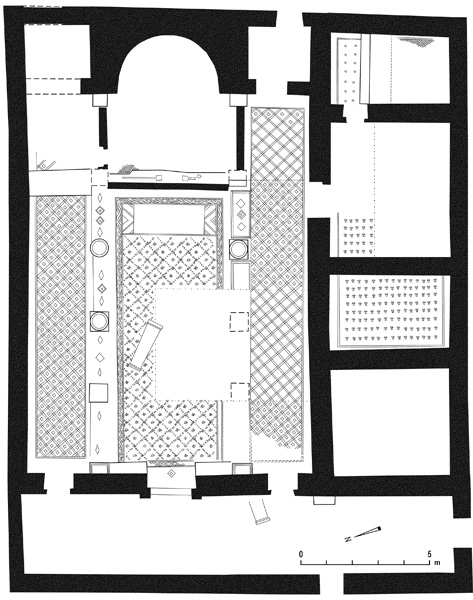
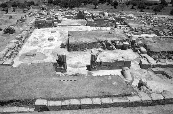
The church is of a basilical type with a central nave, two aisles, and a narthex flanking the entire western side of the building (including its southern wing). At the eastern end of the nave is an internal apse with a room at either side. A southern wing includes rows of rooms along the southern wall of the church. The total length of the church, including the narthex, is 22.5 m, and its width, including the southern wing, is 17.8 m.
The narthex has inner dimensions of 16.5 by 3.7 m. It is entered from a narrow opening from the south and a wider one from the west, and was entirely paved in a rough white mosaic that showed signs of a fire. Three entrances in the eastern wall of the narthex lead into the church hall: a wide middle opening (1.85 m wide) leading directly into the nave, with outer doorposts decorated by a relief of a half column resting on a molded base; and two smaller openings (1.1 m wide) leading to the aisles. The collapsed lintel was found on the surface just east of the southern opening. Next to it was one of the stones of the northern doorpost. On the face of the lintel seen from the narthex was a decoration consisting of three elements, only two of which are preserved: a cross in the center and a rosette to the right.
The prayer hall (inner dimensions 17.3 by 10.8 m) is divided into a nave (11 by 4.6 m) with a bema and apse at its eastern end, and a northern and southern aisle. The aisles are separated from the nave by a row of three columns and two piers, one pier abutting the wall separating the prayer hall from the narthex and the other abutting the apse wall. The column bases stand on square stone plinths, with the mosaic pavement extending up to the plinths. Flanking the central entrance, between the doorposts and the piers, are two stone benches resting upon the mosaic pavement. Two openings in the southern wall lead into the southern wing of the church.
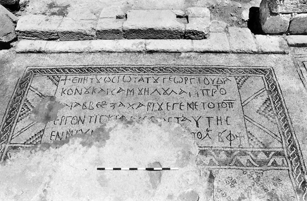
The floors of both the northern and southern aisles (each 14.7 m long and 2.5 m wide) are paved in mosaic carpets with a geometric design of red, black, and white diamonds. The nave floor mosaic is divided into three sections: the western carpet is of a geometric rhomboid design in black on a white background; the central carpet also has a bud pattern in red, black, and white. On the eastern carpet is a five-line Greek inscription covering the entire width of the nave. The translation reads: “Under the most saintly deacon George, and the most illustrious Samuel, and Abbesombos (or Abbeos) son of Zacharias, all the work of this mosaic was done [in the year of Eleuthero]polis 502.” Given that Eleutheropolis (
The bema at the eastern end of the church extends into an internal apse (2.2 m diameter), with a room on either side, the southern room measuring 2.6 by 2.4 m and the northern unexcavated. The bema, 4.8 m wide, projects 3.8 m into the nave. Two ashlar steps lead from the hall up to the bema. Chancel screens stood in a track on the upper step. In the middle of the step, between the screens, is a 0.8 m-wide opening flanked by square depressions for the chancel screen posts. Chancel screens were likely placed on the northern and southern sides of the bema as well, where two steps lead down to the aisles. The bema had a mosaic pavement of which little survives. Two carved stone plinths (0.7 by 0.4 m) were uncovered on it along the apse wall, similar to those found along the narthex wall at the western end of the prayer hall. There are remains of plaster on the walls of the apse and several pieces of red-colored plaster were found during the excavation, raising the possibility that the plaster of the apse walls was painted.
The southern wing (18.7 by 4.7 m) of the church includes three rooms: the western room is square (4.7 by 4.1 m); the middle room is the largest (8.7 by 4.7 m) and is paved in a colorful mosaic carpet with bud designs in red and black on a white background; the eastern room (4.7 by 2.5 m) also has a mosaic floor, with rows of rhombuses in red and black on a white background.
The excavations indicate that the church was constructed in the Early Islamic period. The continuity of the church’s affiliation with the bishopric of Eleutheropolis is attested to by the inscription. The erection of the church during the Early Islamic period raises questions concerning the nature of the Arab conquest and the spread of Islam among the local population.
After the church went out of use, changes were made to the structure at the end of the ninth century CE. Entrances were sealed and walls were constructed over the length of the bema and across the width of the narthex and the rooms of the south wing. These walls were constructed with stones and architectural elements taken from the church. Beaten-earth floors covered the mosaic pavements.
YUVAL PELEG, SHAHAR BATZ
THE SITE
Khirbet Aristobulia extends across the southern and western slope of a hill, 850 m above sea level, about 5 km southeast of Tel Ziph, in the southeastern area of the Hebron Hills. Among the ruins are the remains of buildings, hewn caves, agricultural installations, and water cisterns. The entire site has suffered from pillage and major destruction from later building and agricultural activity. At the northern edge of the ruin, past the dwellings on the crest of the hill, a Byzantine church with a mosaic floor was uncovered.
EXPLORATION AND EXCAVATIONS
The site was mentioned in the nineteenth century by V. Guérin and in the PEF survey. In 1918, A. E. Mader published the site as “The Monastery of Euthymius at Aristobulias,” as part of his comprehensive study of the churches of southern Judea, identifying the site with the monastery that Euthymius built near the village of Aristobulias. Mader described a basilica church at the summit of the site, with a series of rooms to the south of the church. In his view, this was a communal monastery or coenobium, whose monks lived mainly in the surrounding caves rather than within the confines of the monastery itself.