
Beit Sila, Khirbet
THE SITE
Khirbet Beit Sila is located north of Jerusalem, c. 3 km northwest of Giv‘at Ze’ev and c. 2 km south of Ramallah, at c. 650 m above sea level. The site’s ruins include two main centers, 350 m apart. The one in the eastern part of the site is larger and contains the remains of numerous buildings, including a Byzantine church, agricultural installations, and mikvehs. The other center, situated on the slope, 0.5 km west of the site, includes a cemetery and a number of early structures. The total area of the remains is some 6 a.
In the 1920s, A. T. Richardson proposed identifying the ruins of Beit Sila with biblical Shiloh because of the phonetic similarity between the two names. W. F. Albright, on the other hand, identified Khirbet Sailun, north of Ophrah, as biblical Shilo, on the basis of his excavations.
EXCAVATIONS
In the 1990s, Beit Sila was investigated as part of the survey of the region of Benjamin. Two seasons of excavations were conducted at the site in 1997–1998 by S. Batz and A. Reuven on behalf of the Staff Officer for Archaeology in Judea and Samaria. The excavations were concentrated in the central area and in a number of caves and buildings in the western area. Three main periods were distinguished in the excavations: Hellenistic, Early Roman, and Byzantine.
EXCAVATION RESULTS
THE HELLENISTIC PERIOD. The site was founded in the Seleucid period, probably during the reign of Antiochus III (223–187 BCE). A number of coins from this period were recovered from the foundations of the walls and floors of the buildings both in the central and western areas. In the former, several buildings from the Hellenistic period were examined, while in the latter, eight such buildings were excavated in an area of c. 2 a. Based on the numismatic and ceramic evidence, the buildings were constructed in the Hasmonean period, probably during the time of Alexander Jannaeus. The nature of the settlement could not be determined with certainty, but from the buildings’ location, it can be assumed that they formed a Hasmonean outpost that controlled a secondary road running through
THE EARLY ROMAN PERIOD. Finds from the Early Roman period were uncovered in both the main site and the western area. In the main site the remains of a large building were found, 40 by 15 m and dated to the first century BCE–first century CE. Its central location and size indicate that it was a public building. On its western side is an open space and to its south are two rectangular rooms. The outer walls, built of trimmed fieldstones with small stones between them, survive to a height of five courses. The building consists of a number of rooms and was entered through doorways in the southern and northern walls: the southern approached by a street crossing the site, and the northern cut into the wall and opening onto a roofed corridor not preserved in its entirety. West of the building is a mikveh with a flight of stairs and a water channel.
In this period the buildings on the western ridge continued in use and a number of their beaten-earth floors were raised. In most of the buildings the outer walls facing the wadi were widened, probably during the First Jewish Revolt, in which the men of Beit Sila were actively involved. The finds in these buildings included a wealth of stone vessels, some of fine craftsmanship, such as a large container (kalal), and a silver half-shekel coin with the inscription: “half-shekel—Jerusalem is holy,” dated to the year 66 CE.
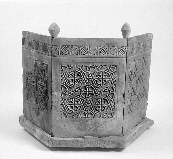
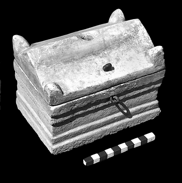
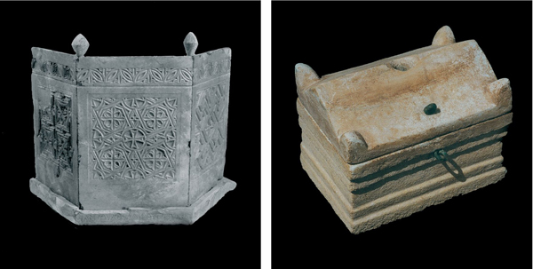
The settlement’s cemetery lies about 200 m north of these buildings. Nine of the 24 rock-cut burial caves examined were excavated. They contained a wealth of objects including ossuaries decorated with rosettes, cooking pots, and glass bottles that were dated to the first century CE. An examination of the finds has revealed that the inhabitants of the site in the Early Roman period were Jewish.
THE BYZANTINE PERIOD. After roughly a 400-year gap in occupation following the First Jewish Revolt, in which both the main site and the western slope were abandoned, the site was resettled. On the western ridge the deserted buildings were reoccupied after minor changes were carried out. The same is true of two burial caves that were reused for burial in the Byzantine period. A number of changes were also made in the center of the site, the major being the construction of the church.
The church was constructed above the ruins of the main structure of the Early Roman period, probably in about 500 CE, and continued in use until the Muslim conquest in the first half of the seventh century. The church was then abandoned and its stones looted; it was later inhabited by nomads who adapted it for their own use. The church, erected in the higher, northern part of the site, served as the main church of the village and perhaps of the neighboring settlements. The church complex incorporated the mikveh west of it, utilizing it as a cistern. A reservoir (5.5 by 3.5 m, 2.5 m deep) was built east of the church.
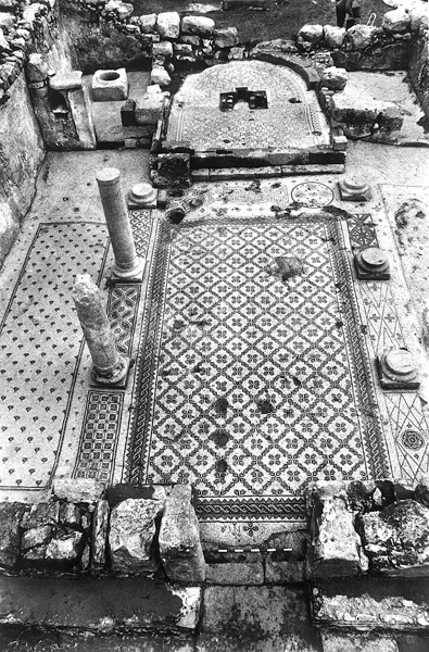
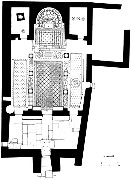
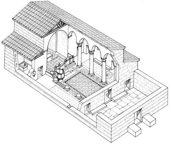
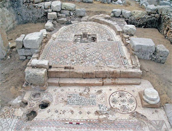
The Church Building. The church is a basilica, 19.8 by 11.5 m, with a single apse. West of the church an open area paved with stone slabs served as the atrium; only its eastern side was excavated. The main entrance has three steps in the western wall of the atrium, leading into the narthex (9 by 4.1 m), which is paved with limestone slabs. From the narthex three doorways open into the hall. They were built in conformity with church architecture of the period: the middle entrance (1.2 m wide) facing the nave is wider than the two (1 m wide) opening into the aisles. Above the main entrance was a lintel decorated with a cross. In addition to the main entrance is a side entrance in the southern wall, in the middle of the southern aisle. The prayer hall, 13 by 9.5 m, is divided into nave and aisles by two rows of three columns each. The bema and apse at the eastern end of the church are flanked by the pastophoria—the diaconicon to the south and the baptistery to the north. In most churches, the room north of the apse served as the prothesis, but here the Eucharist utensils were kept in an outer niche in the baptistery wall. The baptistery, 4 by 2.5 m, is paved with a crude mosaic floor and in its center is a cylindrical limestone baptismal font (6 cm in diameter and 0.55 m deep). The bema extends into the nave and was raised above its floor by two steps with a marble chancel screen at the top.
The Mosaics. With the exception of the apse, all the mosaics in the church are decorated with intricate geometric designs. The mosaics in the bema and the apse contain exceptionally beautiful and varied geometric, floral, and faunal designs in various shades of white, black, red, gray, blue, brown, and yellow. The mosaic in the apse has two rows of medallions; 13 medallions are depicted in the larger, outer row. The central medallion is in the exact center of the apse. It is decorated with a stylized amphora standing on a tripod, whose importance is attested by its prominent location and decoration. Flanking the amphora are depictions of partridges in a heralding position; the other medallions contain vine branches, a pomegranate with filaments, a flower, and water birds. The inner row of medallions also contains a central medallion on the same axis as the upper one. Four medallions decorated with schematic geometric motifs issue from either side of the central medallion, in which the head of a fish, representing Jesus, is depicted.
The Liturgical Furniture. Marble fragments of church furniture recovered in the excavations reveal great diversity. From the church’s latest phase were found a chancel screen of finely carved marble and an altar table that stood in the apse and bears a burial inscription. Beneath the altar was a cavity covered with a marble slab decorated with a cross; within it was a marble reliquary containing a strand of hair, 19 cm long. Another limestone reliquary was found in a niche in the northern wall. Also found were the remains of an offering table near the chancel screen of the bema, and an ambo, built of bituminous limestone, in the northwestern part of the bema. The ambo stood on four legs inserted into the mosaic floor; above it was a hexagonal platform bearing an inscription and five ambo panels decorated with geometric designs and stylized crosses. Railings on either side of the ambo were decorated with stylized crosses. Based on the ornamentation and a comparison of the ambo panels in churches with similar furniture, such as the Church of the Lions in Umm er-Rasas in Jordan, it can be concluded that the church was founded in the last quarter of the sixth century CE. The ambo is unique in its excellent state of preservation.
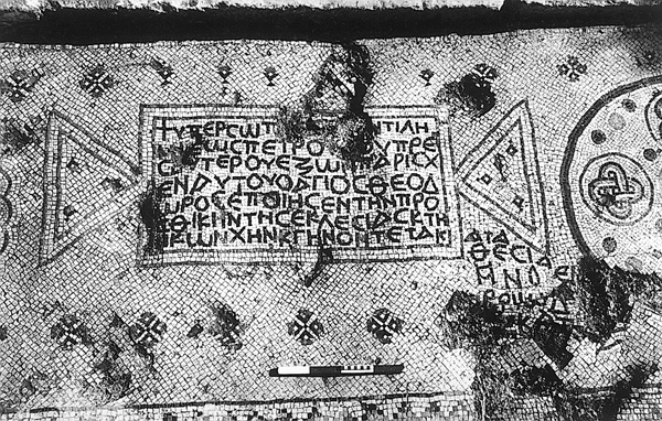
The Inscriptions. Five inscriptions were found in the church, two of them in the mosaic pavement and the others engraved on the liturgical furniture. They were read and translated by L. Di Segni. One inscription, inside a tabula ansata in the mosaic carpet at the base of the bema, reads: “For the salvation and succor of Peter the priest; from what Saint Theodore granted him, he made the main body of the church and the apse; and the deposition [of relics] is done in the month of November, on the tenth [day].” At the western entrance to the nave is a monogram of the name John. The other inscriptions were engraved on the liturgical furniture; one on the base of the altar reads: “For the memory and rest of our Christ-loving brothers Peter, John, Mary, Anastasia, Mary, and Andrew.” Another inscription was found on the platform of the ambo: “O Lord, accept the offering of Thy servant Peter the priest,” and another on the altar table: “For the vow [prayer] of Chry[sippus].”
SUMMARY
Khirbet Beit Sila is an excellent example of the vicissitudes and transformations that took place in the settlements of Benjamin from the Hasmonean–Hellenistic period to the end of the Byzantine period, when most of the churches in the area were abandoned. Jewish inhabitants resided in this region from the Hellenistic period to the destruction of the Second Temple. From the beginning of the fifth century CE, a Christian population reoccupied most of the previously inhabited sites. Like many other Byzantine sites in the area, Beit Sila was abandoned after the Muslim conquest.
SHAHAR BATZ
Color Plates
THE SITE
Khirbet Beit Sila is located north of Jerusalem, c. 3 km northwest of Giv‘at Ze’ev and c. 2 km south of Ramallah, at c. 650 m above sea level. The site’s ruins include two main centers, 350 m apart. The one in the eastern part of the site is larger and contains the remains of numerous buildings, including a Byzantine church, agricultural installations, and mikvehs. The other center, situated on the slope, 0.5 km west of the site, includes a cemetery and a number of early structures. The total area of the remains is some 6 a.
In the 1920s, A. T. Richardson proposed identifying the ruins of Beit Sila with biblical Shiloh because of the phonetic similarity between the two names. W. F. Albright, on the other hand, identified Khirbet Sailun, north of Ophrah, as biblical Shilo, on the basis of his excavations.