The site of Ṣuba occupies a hilltop overlooking Abu Ghosh, some 10 km due west of Jerusalem. Attempts to identify it with biblical Zobah (1 Sam. 14:47; 2 Sam. 23:36) now appear to be baseless, though it may possibly be the town of Σωβρης, which is listed under the district of Bethlehem in the Septuagint (Jos. 15:59a). Rabbinic literature of the Late Roman period also refers to a place called Sebo‘im. Occupation in the Iron Age and Byzantine periods is indicated by rock-cut tombs and mosaic fragments.
In the twelfth century, Christian writers identified the hills of Modi‘in in this area, a mistake that persisted into the eighteenth century. The German pilgrim Theoderic, who traveled in the area in 1169 or 1172, also called these hills Belmont and noted that the village of Emmaus (Abu Ghosh) lay nearby. By this time the Hospitallers, who had acquired Abu Ghosh around 1140, had built a castle at Belmont. Its castellan, who is first mentioned in 1157, apparently acted as bailiff (or administrator) of the order’s estate, whose center was at Abu Ghosh. Arabic sources record that Ṣuba fell to Saladin in August 1187, while western sources state that Saladin ordered his brother al-‘Adil to destroy it along with other captured Frankish castles in September 1191. It is uncertain whether the Franks ever reoccupied it; Richard I of England, however, was reportedly at Abu Ghosh in June 1192, and between 1229 and 1244 the area was nominally under Christian control. A cache of four English pennies (1180–1247) found in the northern range of the castle might therefore relate to reoccupation in either of these periods. In the Mameluke and Ottoman periods, a village of Muslims and some Christians was established among the ruins of the castle. In 1834, it was stormed and partly dismantled by Ibrahim Pasha.
The remains of the Crusader castle were investigated for the British School of Archaeology in Jerusalem in four seasons of excavations, from 1986 to 1989, by R. P. Harper and D. Pringle.
EXCAVATION RESULTS
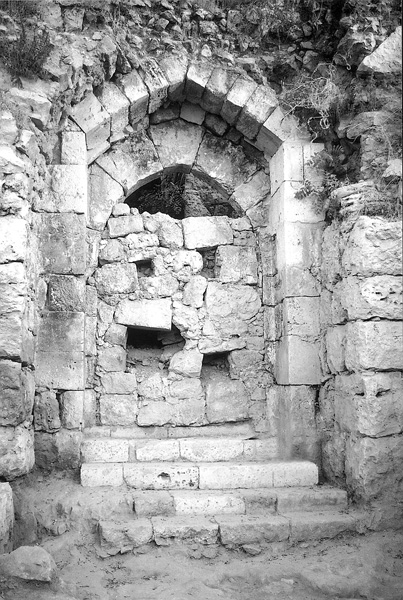
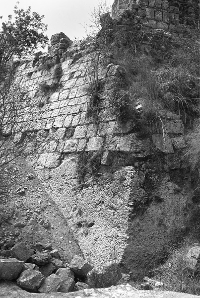
The excavations revealed that the outer walls of the castle describe an irregular polygon following the shape of the hill and measuring overall 100 (east–west) by 115 m (north–south). Only the sloping talus of this wall survives, partly rock-cut and partly built in masonry. From the outer gate on the southeast, a path appears to have led up in a clockwise direction to a rectangular inner ward (33 m east–west by 40 m north–south) on the top of the hill. This consisted initially of three ranges of vaulted buildings set on three sides of a central courtyard, which was closed by a wall on the east. Access was provided through a gate, 1.7 m wide, on the east, and by a postern, 0.8 m wide, on the north; as in the nearby Crusader manor house at Aqua Bella, each door was flanked by a solid projecting turret. Stone staircases in the courtyard suggest that there had been an upper story. Later, two groin-vaulted bays were built successively across the eastern side of the courtyard, completing its enclosure; beneath the northern of these bays a winepress was built. The construction of the southern vault would effectively have blocked the original main gate; after that, entry would have been either at the first-floor level (for which there is no independent evidence) or through the narrow northern postern gate.
On the southeast, between the inner ward and the outer wall, there survive remains of an outer range of barrel-vaults. This follows a polygonal course, roughly parallel to the outer wall, and was entered from the uphill side through a wide doorway. Inside is a row of stone mangers, indicating that the vault had been used as a cattle byre or stable for horses.
Although the castle’s inner ward did not survive above basement level, it seems likely that the main living area would have been on the first floor, with agricultural processing (such as wine-making or olive-pressing) carried out below. Buildings of this kind are usually interpreted as the Crusader equivalent of the Western maison-forte or manor house, the dwelling of a lesser feudal tenant. But, whereas at Aqua Bella the Hospitallers seem to have acquired an existing manor house and converted it into a priory or infirmary, at Belmont a similar type of structure became the nucleus of a castle. The manor house from which Belmont Castle developed had probably originally been built by a secular owner or tenant. The stages by which it developed into a castle—probably only after its acquisition by the Hospital—may be paralleled at other rural sites, such as Burj Bardawil and et-Taiyiba (both near Ramallah). The concentric planning that it displays, however, was taken a stage further by the Hospitallers in the castle of Belvoir (Kaukab el-Hawa), which they built in Galilee between 1168 and 1187.
The excavation at Ṣuba provided few clues as to the precise operation of the castle. Its origin as a manor house, however, and the existence of a winepress in the inner ward suggest that its principal function continued to be that of an estate center. From here the castellan would have overseen the agricultural exploitation of the region, providing food and income for the Hospital in Jerusalem. Indeed, the faunal material from the excavations analyzed by P. Croft can be correlated with the list of meats known from documentary sources to have been served to patients in the Hospital in the 1180s. The most significant features of the data from this standpoint are: (1) the rise in pork production in the Crusader phase (to 34.8 percent), as compared with earlier and later periods; (2) the roughly equal importance of sheep and goats, contrasting with higher proportions of goat in earlier and later periods; (3) evidence that 42 percent of the caprines were being killed before they were two-and-a-half years old, suggesting that the production of meat (or milk and cheese), including fleeces, was more important than wool; (4) the abundance of chicken and the presence of wild and probably also domestic pigeons; and (5) a peak in the quantity of fish bones occurring during the Crusader period. One major difference is in the significance of cattle at Belmont, where in terms of meat weight they outweighed pigs and caprines combined, although the individual number of animals was relatively small. The mortality evidence also suggests that cattle were being exploited for both meat and dairy products. The explanation may simply be that in country areas cattle (or oxen) were also used for other purposes, such as plowing and pulling carts, and that their meat was in any case considered too tough to be served in the Hospital.
The military function of Belmont may never have been very great. Although it overlooks the Jerusalem road that passes through Abu Ghosh, this was not the main road to the city in the twelfth century. Its construction belongs to a period of increasing insecurity faced by the Crusader Kingdom from the late 1160s onwards.
DENYS PRINGLE
Main publication: R. P. Harper & D. Pringle, Belmont Castle: The Excavation of a Crusader Stronghold in the Kingdom of Jerusalem (British Academy Monographs in Archaeology 10), Oxford 2000; ibid. (Review) LA 53 (2003), 499–502.
Studies: V. Guérin, Description géographique, historique et archéologique de la Palestine, Judée, 1, Paris 1868, 265–278; C. R. Conder & H. H. Kitchener, Survey of Western Palestine, Memoirs, 3, London 1883, 18–19, 157–158; C. Clermont-Ganneau, Archaeological Researches in Palestine, 1, London 1896, 23, 480–481; F. M. Abel, Géographie de la Palestine, 2, Paris 1938, 423–424, 452; G. Beyer, ZDPV 65 (1942), 180–181; R. P. Harper & D. Pringle, ESI 5 (1986), 12–13; id., Notiziario di Archeologia Médiévale 45 (1987), 6; id., Levant 20 (1988), 101–118; 21 (1989), 47–61; R. P. Harper, ibid., 19 (1987), 219–220; 30 (1998), 212; id., RB 95 (1988), 277–279; id., ESI 7–8 (1988–1989), 13–14; 9 (1989–1990), 57–58; D. Pringle, Fortress 1 (1989), 14–25; id., Secular Buildings in the Crusader Kingdom of Jerusalem, Cambridge 1997, 96; S. Wolff, AJA 95 (1991), 535–536; S. J. Simpson, Levant 27 (1995), 247; D. Barak & R. Kark, JSRS 13 (2004), xxviii.
Denys Pringle is a Professor of Archaeology at the University of Cardiff who specializes in the material culture and church buildings of the Crusader Kingdom in Jerusalem and castles and fortifications in Western Europe and the Mediterranean world. Pringle was awarded the Prix Gustave Schlumberger by the Académie des Inscriptions et Belles-Lettres of the Institut Français, Paris, for academic publications in 2003.