Caesarea
THE ISRAEL ANTIQUITIES AUTHORITY EXCAVATIONS
EXCAVATIONS
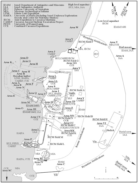
Large-scale archaeological excavations were carried out at Caesarea from 1992 to 1998 by the Israel Antiquities Authority (IAA); they were directed by Y. Porath. The project included the excavation of a 100–150-m-wide strip along the coast between the theater complex to the south and the excavations of the Combined Caesarea Expeditions (CCE) to the north; the western part of the temple platform and the area between this platform and the eastern quay of the port of Sebastos; both sides of the southern Crusader wall (continuing the salvage excavations carried out in 1989); the bottom of the Crusader moat (cleared in the 1960s by A. Negev), from the southern gateway to the northern gateway; and the area southwest of the theater. In addition, salvage excavations were conducted within the area demarcated by the Byzantine wall; in structures outside the wall; on the necropolis; in agricultural areas to the east, north, and south of the city; and along the aqueducts that carried water to Caesarea from outside the city.
EXCAVATION RESULTS
Fills from the Herodian period contained remains of periods predating the Hellenistic Straton’s Tower: Epipaleolithic flint artifacts, including blades and debitage, fragments of a Middle Bronze Age jar and cylindrical juglet (probably from a tomb), and numerous sherds from the end of the Iron Age and the Persian period. These sherds attest that the site was probably founded at the end of the Iron Age; however, no building remains of a settlement prior to the Hellenistic Straton’s Tower have been uncovered so far. Building remains of Straton’s Tower were discovered in excavations conducted in the northern part of the Crusader moat, indicating that the Hellenistic city did not extend as far as Caesarea’s temple platform. Cist graves in the southern necropolis of Straton’s Tower, cut into the kurkar or dug into the sand, were uncovered beneath the southern part of the Herodian city.
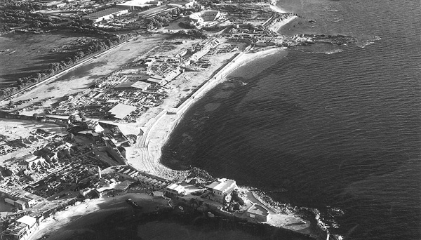
THE HERODIAN PERIOD: THE REIGNS OF HEROD AND ARCHELAUS. The center of the city of Caesarea, which was founded by Herod, was occupied by a temple dedicated to Roma and Augustus, erected on a platform supported by high stone walls and divided into compartments filled with earth and debris. The western walls of the platform were constructed of large kurkar stones with marginal drafting, laid as headers and stretchers. The southern wall of the platform was constructed at a right angle to the western wall, while the northern wall is at an obtuse angle (106 degrees). A paved street, perhaps the decumanus maximus, runs parallel to the northern wall. In Herodian times the western façade of the platform was without vaults and consisted of a large recessed area (c. 85 by 21 m) between two projecting wings that extended westward from the platform, creating a plaza connecting the platform and the inner harbor. A drainage channel at the western edge of the plaza carried water southward, outside the harbor area. (On the CCE’s excavation of the temple platform, see below.)
An arena for chariot racing, built like a Roman circus, was uncovered south of the harbor near the sea. The circus was found in the exact location mentioned by Josephus (Antiq. XV, 341, though he used the term amphitheatron) and dubbed “Herod’s circus” by the excavators. The western part of the circus was built on sand deposited following the construction of the artificial harbor, but this side of the structure was subsequently destroyed as a result of stone robbing as well as erosion by the sea. The original circus had an elongated U-shaped track (301 by 50.3 m) divided lengthwise through its center by a spina constructed in segments, and eight starting gates (carceres). The gates were built in a radial pattern along an arc with a radius of 55 m. Seats for the spectators were built on the eastern and southern sides only, over a fill between two walls (total width 9.25 m). The western wall of the circus (4.5 m wide) supported the fill of the track and protected it from the sea waves. The tribunal was located in the center of the eastern cavea, above a system of vaults containing concealed stairs. The circus was separated from its immediate surroundings by a deep, wide dugout (12–16 m wide and 4–6 m deep). Herodian coins found in the earliest occupational levels of the circus date its construction to the time of Herod. This facility held the chariot races during the festivities celebrating the inauguration of Caesarea (Josephus, Antiq. XVI, 137). (On the CCE’s excavation of the starting gates, and on the slightly different interpretation of the facility as a hippo-stadium, see below.)
In the area south of the theater, a segment of the southern wall of the Herodian city (1.8 m wide) was exposed. The wall and its round tower were constructed of large blocks with typical marginal drafting, and the adjacent fills contained sherds of the Herodian period. The discovery of the southern wall attests that the theater was included within the fortified limits of the city (contrary to the Italian expedition’s view), and that the northern wall with its gateway set between round towers (exposed by the Italian expedition and examined by the Joint Expedition to Caesarea Maritima, JECM, in 1978) is also to be ascribed to the earliest construction carried out by Herod. The exposed sections of the Herodian wall are located c. 560 m (3 stadia) from the temple platform, equivalent to six insulae.
THE ROMAN PERIOD. In 6 CE, the Romans replaced Herod’s son Archelaus with a Roman governor of the equestrian rank (titled praefectus and later a procurator) and made Caesarea, instead of Jerusalem, the seat of their government. The choice of Caesarea as the capital of Roman Judea led to a surge of construction in the city.
The area east of Herod’s circus was prepared for construction at the beginning of the first century CE: the surface was leveled and the dugout around the circus was filled. The fill contained a large amount of Herodian ware and numerous coins, the latest of which was struck by the governor Marcus Ambibulus (10 CE). In the leveled areas, the wealthy residents of Caesarea built luxurious mansions with walls covered in colored plaster and mosaic or plastered floors.
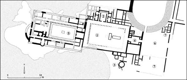
The area south of the circus and west of the theater was occupied by the praetorium or government compound of Judea, which continued in use until the beginning of the fourth century CE. (Another government complex with a law court was revealed by the CCE’s excavations farther north, in their areas CC and NN; see below.) In the government compound the various expeditions—Italian, Hebrew University, University of Pennsylvania, and the IAA, in chronological order—exposed the governor’s palace, several administrative offices and chambers, and the lower courses of a rectangular platform with steps between antae on the eastern side, perhaps for the Tiberium, mentioned in the inscription of Pontius Pilate.
The large and sumptuous promontory palace, 175 by 54 m at its largest, was erected on two levels along the southwestern boundary of Herod’s circus. The IAA excavated the upper level, which included a peristyle courtyard (65 by 42 m), a northern wing (65 by 22 m), a southern wing (at least 61 by 28 m), and an elaborate entry complex to the east (45 by 22 m). An open expanse on its eastern side was shared by the palace, the administrative offices to its east, and the southern entrance to the circus. The parts of the palace adjoining the circus were built on the fill of the dugout enclosing the circus from the time of Herod and Archelaus. The palace walls reaching the circus extend up to its outer wall but are not incorporated into it. In the fill beneath the early floors of the rooms in the northern wing were recovered sherds from the end of the first century BCE to the beginning of the first century CE and a coin of Archelaus.
The IAA’s excavations revealed that the construction of the palace, or at least its upper level, should be ascribed to the earliest Roman governors, and not, as has been suggested by E. Netzer, B. Burrell, and K. L. Gleason, to Herod. The palace served as the seat and center of activities of the governors of Judea (named Palaestina after the suppression of the First Jewish Revolt) until the beginning of the fourth century CE. The latest dated inscriptions found in the palace are from the time of the governor Aufidius Priscus, dedicated to the co-emperors Constantius Chlorus and Galerius (293–305 CE). East of the palace were uncovered the administrative offices of the government compound with their courtyards and corridors. In two offices from the later phase of the compound, inscriptions were found in the mosaic floors, one of which mentions the offici custidiar and the other the frumentariorum.
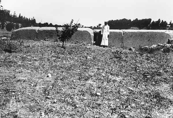
Chariot races were held in Herod’s circus until approximately the middle of the second century CE. During the course of its existence, a cavea was added on its western side and the number of seats for spectators increased from c. 7,500 to 12,500. The floor of the arena, the stone-built spina, and the starting gates also underwent several phases of renovations (on the CCE’s excavation of the gates, see below). The filling of the dugout surrounding the initial circus allowed access to the seats from the outside, instead of from inside the arena as in the first phase. At the beginning of the first century CE the metae (turning posts) at the ends of the spina were connected to the municipal water system, but were later separated from it.
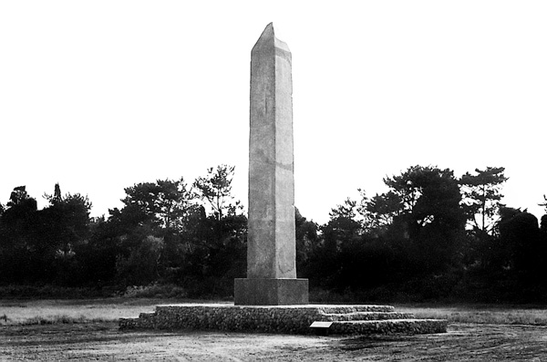
In 1996, the IAA renewed excavations along the course of the spina of the eastern circus, which replaced Herod’s circus in the middle of the second century CE. Examination of the eastern circus by the JECM in 1974 revealed that it measured 90 m wide by more than 412 m long; it is estimated that it could have accommodated more than 30,000 spectators. In the middle of the arena of the eastern circus three pieces of a broken obelisk of pink Aswan granite were found where it had fallen. Sections of the spina foundation were exposed (5.5 m wide and 1.15 m beneath the arena floor), as well as the meta prima and patches of the arena’s plaster floor. Around the obelisk the base of the spina had been widened on each side by 0.75 m, and sunken to a depth of 2.8–2.9 m below the arena surface. A solid base (c. 9 by 7 m) on which the obelisk was placed was thereby created. The obelisk was more than 14 m high and weighed over 80 tons. It was restored by the IAA and returned to its original position. An elongated euripus (water basin) lined with large marble slabs (1.5–3 m long, 1.02–1.05 m high, and 0.32–0.39 m thick) and with a white mosaic floor (c. 25 tesserae per square decimeter) crowned the spina. The euripus atop the spina terminated in the south in a semicircular recess, as in the Circus Maximus in Rome and in depictions on mosaic pavements at Carthage and Volubilis. The meta prima was exposed at the southern end of the spina. On top of it were erected three conical posts (metae) of pink Aswan granite, each consisting of two sections (total height 5.4 m, diameter 1.70–1.75 m at base and 0.32–0.35 m at top) that stood atop large marble pedestals (diameter 2.15–2.20 m), shaped like huge column bases. Three building phases could be distinguished in the meta prima; in the latest phase it was extended to fit the size of the huge conical posts. The foundation of the later phase cut through the earlier floors of the arena. The obelisk, the marble slabs lining the spina, and the conical posts on the meta prima all belong to this latest building phase. The eastern circus continued in use until the end of the Byzantine period.
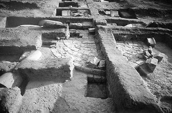
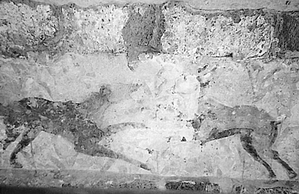
After the chariot races were transferred to the eastern circus, the southern part of Herod’s circus was turned into a Roman amphitheater where gladiatorial contests (munera), hunting games (venationes), and fights between wild animals (bestearii) were staged. The floor of the arena was dug 0.5 m below the floor of Herod’s circus and the bare wall was plastered and decorated with frescoes. The plaster and drawings required frequent repair because of their exposure to the elements and proximity to the sea, and were changed due to changes in artistic taste. The earliest frescoes contained various animals drawn to different scales against a background of schematically rendered flora. Among the animals appear the lower limbs of a man walking, probably an animal tamer or a gladiator. The subsequent fresco presented imitations of colored marble panels that were later replaced by colored plaster with a red stripe. The latest plaster layer was not in color.
In the third century CE, the amphitheater occupying the southern section of Herod’s circus was no longer in use. The entire facility was later put into operation once more for a short time as an arena for chariot races, apparently during the renovation of the eastern circus (when the obelisk was erected and the spina reshaped). A new meta prima was constructed in this phase, with foundations made of drums of kurkar columns in secondary use sunk into the plastered floor of the previous amphitheater. It seems that the latest phase of the caceres belongs to the same period. The latest coin found in the arena surface of that provisional circus dates to the Emperor Alexander Severus (222–235 CE), indicating that the transition was not carried out before the Severan dynasty.
Toward the end of the first century CE, the square in front of the western façade of the temple platform was paved with stone slabs; the latest coin found in the fill below the pavement dates to the time of Titus (79–81 CE). A nymphaeum with three arched niches was added to the western façade of the northern projecting wing bordering the square. The channels for the pipes of the nymphaeum’s fountains and the niches were carved into the Herodian wall, with no regard for the joints between the blocks of the original construction, and the basin that collected the fountain’s water was built next to it. The statues found on the site—one in A. Negev’s excavations and one in the IAA’s—probably came from the niches that had decorated the nymphaeum.
It seems that the network of streets in the southwest was planned in the Herodian period, and their course remained unchanged until the end of the Byzantine period. The early streets were paved with a layer of crushed kurkar; during the second and third centuries with dolomitic limestone; and in the Byzantine period with kurkar stones mixed with reused dolomitic limestone. Lead or clay pipes laid beneath the streets carried water from the high-level aqueduct. A network of drainage channels was dug to receive rainwater and excess water from the municipal water system. (See below further discussion on the streets and their network in light of the CCE’s excavations in their areas CC, KK, and NN.)
During the first century CE the round tower of the southern wall was replaced with a rectangular tower, and a wall was built along a course that reduced the area of the fortified city. These were probably constructed at the end of 66 or beginning of 67 CE, after the annihilation of the Jewish community and as protection from raids carried out by the rebels against the gentile cities, including Caesarea (Josephus, War II, 259). Parallel to the course of the new wall, a lead pipe was exposed that carried water from the high-level aqueduct to the Roman praetorium in the southwestern part of the city. The southern Herodian wall was still standing when the imperial theater that replaced the Herodian theater was constructed (according to the Italian excavators, under the Severan dynasty).
In 2000, part of a semicircular structure (external diameter c. 85 m) was exposed approximately 200 m east–southeast of the theater. It has perimeter and radial walls separated by wedge-shaped “rooms” narrowing toward the center. In plan, the structure recalls the vault system supporting the cavea of a theater. About 50–60 m to its north, part of a building with three entrances (the central one in a curved niche and the other two in rectangular niches) was excavated in 1985 by M. Peleg and R. Reich. They described the structure as a “city gate in the southern wall of Byzantine Caesarea,” but it appears that the “gate” of the Peleg-Reich excavations was in fact part of a scaenae frons of a theatrical structure. This structure and the semicircular structure of the 2000 excavation should probably be interpreted as a theater or an odeon, perhaps the odeon mentioned by the Byzantine chronicler Malalas (Chron. 10, 46).
Outside the city wall, part of a villa of the second–third centuries CE built on top of the eastern kurkar ridge was excavated by the IAA. A well with a water wheel (saqiya), as indicated by the typical pots found on its bottom, supplied water to the villa.
A cemetery extended outside the city walls, mainly in areas unsuitable for cultivation. Most of the burials were in pits lined with stones or terracotta tiles, and in several cases in burial caves carved out of the kurkar crest east of the city. One of the loculi caves with a pit for the collection of bones apparently served the Jewish community. At the end of the first century CE, the area outside the southern wall west of the rectangular tower was converted into a cemetery that was delimited on the south by a stone wall. In the section excavated, 34 stone-built cist graves were found with tombstones in the “Italian” style, similar to those on the Via Appia. The bodies were cremated in 4 out of the 11 tombs examined; the others were articulated skeletons. In some of the tombs the coffins were made of terracotta tiles stamped L X FRE, an abbreviation of the name of the Tenth Roman Legion. In a number of cases, Latin or Greek inscriptions engraved on marble slabs were placed atop the tombs, however none were preserved in situ. Numerous burials of infants and fetuses were found in truncated jars or in cooking pots dug into the ground between the stone-built tombs. The finds in the tombs were very meager and consisted mainly of sherds and lamps from the second–third centuries CE. In tomb L40279, a coin of Hadrian was found near the left shoulder of the body. In tomb L40259, a young girl was interred with her gold earrings, and gold and silver rings. The cemetery served the pagan community of Caesarea and was perhaps intended for the officials of the praetorium. By the third century it was no longer in use and its area was confiscated for the urban expansion beyond the southern Roman city wall.
THE BYZANTINE PERIOD. The change in status of the province of Palaestina as a result of the unification of the empire under Constantine the Great and the recognition of Christianity as the religion of the empire (324 CE) led to changes in civic buildings of the provincial capital Caesarea and an increase in construction in the city. The Roman praetorium of Palaestina Prima was moved and its functions divided among several building complexes in different parts of the city. The area of the Roman praetorium and the adjacent Herod’s circus was used for private dwellings and municipal buildings, with two courtyard buildings erected on top of the northern and southern wings of the abandoned promontory palace. Above the outer wall of the eastern cavea of the circus two rows of marble columns, perhaps a promenade, now extended southward above the office of the frumentariorum toward the theater. Public toilets, built partly above the eastern wall of the entrance of the abandoned palace, were incorporated into the southern gate of Herod’s circus.
During the fourth century the western part of the temple platform was extended westward as a vaulted structure into the square west of the original building. The foundation trench of the excavated vaults cut through earlier floors and a new higher floor was associated with them. A thick plaster floor was laid on top of the vaults. The assumed Herodian stairway was moved to the area west of the façade of the vaults.
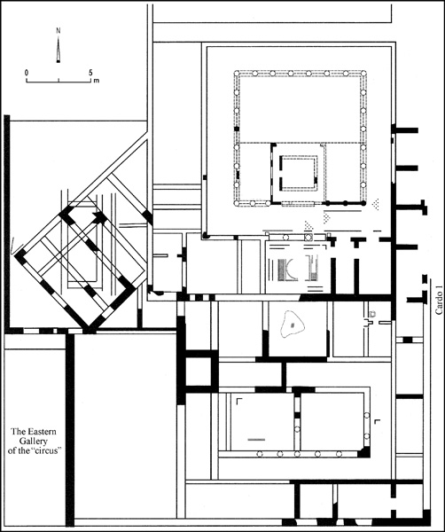
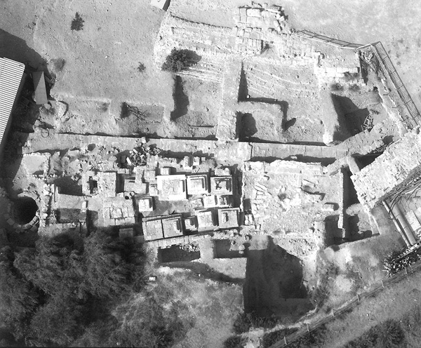
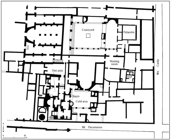
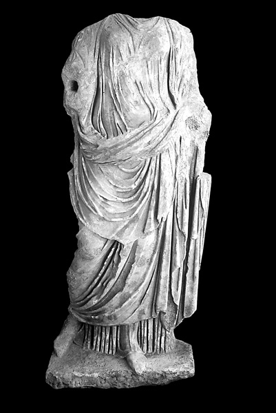
In the fifth century a public bathhouse was erected in the southern part of insula W2S3, above the building that replaced the Roman mansion in the third century. In addition to hot and cold bathing areas, the bathhouse included a dressing room (apodyterium), a magnificent palaestra, public toilets, rooms, and courtyards. The caldarium complex in the western part of the bathhouse was built on top of a fill that covered the eastern cavea of Herod’s circus. The bathhouse consisted of two adjoining bathing complexes which could be operated in unison or separately, either as summer and winter facilities or as separate units for men and women or different classes. The larger wing of the bathhouse was arranged along a circular route and, after its renovation, along two back and forth routes, similar to the original arrangement in the smaller complex. On the floor of the frigadarium of the small complex a marble sculpture of the torso of a woman from the Roman period was found, having been put to secondary use there as decoration. Water was supplied to the bathhouse through clay pipes leading from the municipal conduit passing under cardo W1. The bathhouse was later detached from the municipal water supply and received water from a well with a water wheel in the southwestern area. (On the CCE’s excavations of the warehouse complex adjacent to the bathhouse to the north in their area KK, see below.)
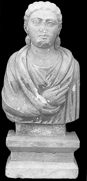
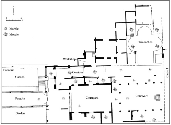
In the sixth century, after the promenade from the beginning of the fourth century went out of use, a palace was built in the southern part of insula W2S4. The palace included a courtyard surrounded by rooms, as well as a courtyard with columns on three sides; to its north was a trefoil-shaped hall (triconchos). The western side of the palace was occupied by an irrigated sunken garden with a stone-built pergola. The western wing (garden and pergola) was dug into the fill that sealed Herod’s circus and damaged the lower rows of seats. The palace was paved with marble and mosaic floors; some of the walls were covered with marble panels. In debris on the floor of the trefoil-shaped hall were fragments of a multicolored mosaic with human figures that had covered the walls. A mosaic-paved corridor connected the various wings of the palace. Two rooms of a complex north of the palace were attached to the palace complex by a doorway cut in the northern wall of the corridor. On the plaster floor of the larger room was found a layer (0.3 m high) of cut stones of various colors that had been inlaid in opus sectile panels prepared to decorate the walls. The room served as the workshop where the stone pieces were cut and the opus sectile panels were produced. In the workshop were also found raw materials, partially cut pieces of stone, production waste, and tools. The systematic manner in which the panels were stored and the sealing of the room from the outside indicate that the cessation of production was planned in advance, perhaps in the face of some kind of danger (such as the Persian invasion of 614 CE or the Arab siege and conquest of 640/641 CE) with the intention having been to subsequently return to work. The statue of a magistrate with head and arms cut off, found in a pile of stones in this area, may have come from the palace.
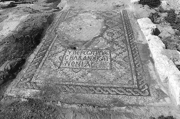
Above the ruins of the southern part of Herod’s circus, a building of basilical plan on an east–west axis was exposed. It consisted of a hall with an internal apse, a narthex, and an atrium, and was probably a church. The hall was paved with a multicolored mosaic with geometric motifs and a Greek inscription: “For the salvation of Silvanus and Nonias.”
In the area between the Byzantine palace and the basilica were uncovered portions of buildings paved with mosaics that were erected after the promenade went out of use. One of the mosaic floors was decorated with a partly damaged Greek inscription of seven lines that reads: “Ioanis son of Procopius paved the…in memory of …in the month of March…Amen.” The mosaic floor of another hall (c. 9.2 by 4.6 m) was decorated with round medallions (c. 0.45 m, external diameter) arranged in 15 parallel rows, seven medallions to a row, each medallion containing a depiction of a bird. To the west of the hall was a stone-built fishpond that apparently belonged to the building. Among the buildings of the Byzantine period destroyed when their stones were plundered in a later period were several rectangular stone storage facilities built inside pits (called cellar granaries or cellar bins). The granaries were always built in even-numbered groups of two, four, six, or eight.
Salvage excavations carried out in 1999 northwest of the theater exposed a public toilet complex from the Byzantine period that probably served those attending the theater. When the building went out of use, its drainage channels were filled with debris and a large amount of sherds from the end of the sixth–beginning of the seventh century CE.
The remnants of an east–west wall from the Byzantine period (c. 3.8 m wide) were found under the western section of the southern Crusader fortification. The wall terminated about 5 m west of the eastern quay of the Port of Sebastos, and its foundation was dug below sea level. It seems that the wall was part of the harbor’s southern breakwater, which was repaired during the reign of the emperor Anastasius I (491–518 CE). In 2000, a section of the southern wall of Byzantine Caesarea was uncovered (21 m long, 2.65 m wide) c. 10 m south of the Roman theater/odeon, i.e., about 50 m south of the line of the Byzantine wall proposed by M. Peleg and R. Reich.
In 2004, the IAA reopened as part of a conservation project the area of the figurative mosaic excavated in 1955 by S. Yeivin on a hill about 500 m outside the Byzantine fortifications to the northeast. Yeivin had suggested that the figurative mosaic belonged to an unroofed church, associated with the nearby cemetery, but R. Reich and others assumed the remains belonged to a Byzantine villa. Limited excavations directed by Y. Porath were carried out in 2005 south and west of the figurative mosaic. It was shown to belong to an elegant central courtyard of a large mansion (over 50 by 45 m). Fragments of mosaic floors uncovered in the debris over the intact mosaics of the ground floor indicate that several rooms of the mansion had a second story. The mansion was destroyed by fire and the stone walls were later dismantled and removed. The artistic style of the mosaic floors and the finds revealed upon them date the mansion to the Byzantine period (sixth–mid-seventh century CE). The most splendid find is the surface of a wooden “sigma” table (1.04 by 0.97 m), made of an inlay of glass plates that fell face down on the mosaic pavement (the wood tabletop and legs were burnt to ash). The square plates of the inlay (c. 4 by 4 by 0.5 cm) were produced as flat pieces in gold glass technique, then pressed into molds to create a relief of a cross or flower. Since the mansion was decorated mainly with secular motifs, and only a few typical Christian motifs, it probably functioned as the residence of a respected and wealthy member of the bureaucratic-political or commercial elite of Caesarea. It seems that the mansion, located outside the walls of Caesarea, was destroyed in a raid prior to (or during) the Arab siege and conquest of Caesarea (640/641 CE).
From probes made in 1990 north of the Byzantine wall and east of the low-level aqueduct, it appears that the surface level in the Roman–Byzantine period was lower than at present. The areas up to c. 5 m above sea level were irrigated and used for cultivation, the soil enriched by the dumping of the city’s organic waste. Higher land was used for burial. In the lower areas were exposed a pool that received water from a well, a section of a masonry irrigation system, and part of a room with a multicolored mosaic floor.
In 1992, Y. Ne’eman discovered a section of a paved road running outside Caesarea to the east, probably the road to Megiddo. It crossed
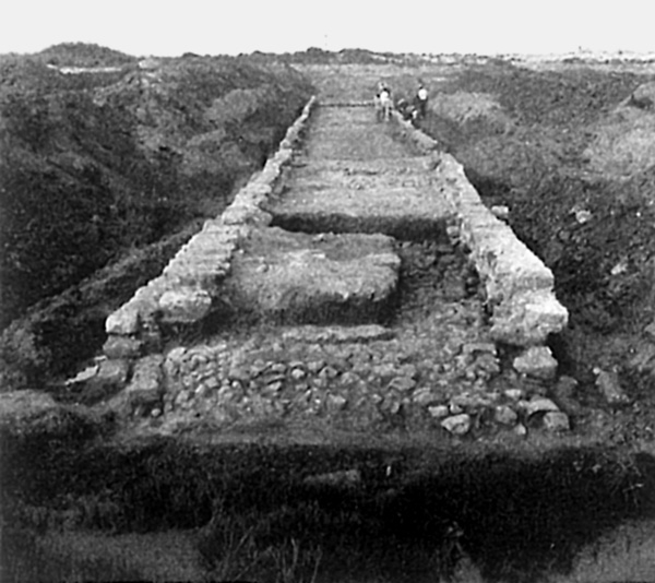
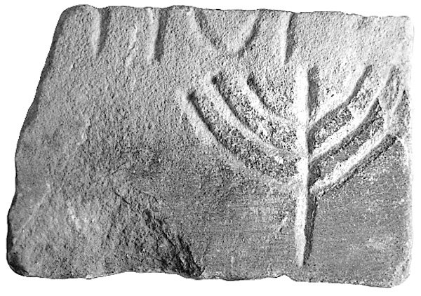
Outside the Byzantine wall, cemeteries extended around the city, mainly in areas unsuitable for agriculture. In 1992, a cave with arcosolia carved out of the kurkar ridge was excavated southeast of the city. In the cave sealed lamps of a type generally associated with the Samaritans were recovered. Three of the lamps were decorated with a seven-branched menorah. Soot was found on all the nozzles, even though the seal on some of the lamps had not been broken. In 2002, a section of a cemetery was exposed in the dunes east of the city with cist graves lined and covered with kurkar stones. In several of the graves the dead were interred in limestone sarcophagi.
THE EARLY ISLAMIC PERIOD. With the Arab conquest of 640/641 CE and the resulting loss of Caesarea’s political-administrative status and cessation of maritime trade, the municipal network collapsed. Many of the inhabitants left the city, a large number of its buildings were abandoned, and the aqueducts leading into the city fell into disrepair (see below). An example of these changes was seen in the excavations in the southwestern sector of the city, where the imposing Byzantine buildings—the bathhouse, palaces, basilica, storerooms, and granaries—were no longer used in the capacities for which they had originally been built. The plundering of all the portable furniture and objects was followed by the systematic removal of wooden fixtures (roofs and doors), metal fittings (hinges, pipes, and clamps for fastening the marble panels), and valuable stone articles (columns and their components, marble panels lining the walls, and floor tiles), and eventually the dismantling of the walls. Dismantled marble objects were piled up in the palaestra of the bathhouse and the sunken garden of the Byzantine palace in insula W2S4, having been prepared for transport from Caesarea. In the complex south of the bathhouse were piles of kurkar stones that had been detached from the walls and sorted for reuse.
The remaining occupants of Caesarea were concentrated mainly near the harbor and in a few rooms of the abandoned Byzantine structures. Between the abandoned and half-dismantled buildings, garden plots were laid out for cultivation, enriched by soil and organic waste, ridded of collapsed stones, and fed by a new irrigation system using water from wells dug for this purpose. The lower parts of the walls were left in place to serve as protection from wind, sand, and salt spray from the nearby seashore. The advanced irrigation network was uncovered in the rooms of the ground floor west of the palaestra of the abandoned bathhouse. (See below similar findings from the CCE’s excavations in their areas CC, KK, and NN.)
In excavations conducted northwest of the theater in 1999 it became evident that the fortress (fortezza) which replaced the theater was constructed after the middle of the sixth century (contrary to the claims of the Italian excavators). The northern wall of the fortress incorporated walls of the Byzantine structures, including the public latrine noted above. The sherds recovered in the concealed channels of the latrine postdate the middle of the sixth century CE. If this fortress is not the kastron mentioned in Christian sources as existing in Caesarea during the Persian conquest (614–627/628), it must have been constructed after the Arab conquest (640/641), when the Caliph ‘Abd al-Malik ordered the city to be fortified.
Evidence that Caesarea once again became a fortified city during the rule of the Abbasid caliphs was uncovered in the IAA excavations. The southern wall (2.8 m wide) of the Abbasid city was discovered beneath the Crusader wall. The wall’s western extension was constructed above the wall attributed to the renovation of the harbor’s southern quay by the emperor Anastasius I; the continuation of the wall ran eastward along a straight course above the buildings of the Roman–Byzantine city. A cellar granary typical of the Abbasid period was uncovered along the inner face of the wall; it was later filled in during the construction of the Jaffa Gate of the Crusader wall.
The harbor of Caesarea was prepared for use once again and the western part of the inner basin was cleaned of sediment. The earth removed in the deepening of the harbor was deposited above the Byzantine remains south of the Early Islamic city wall, at a distance that would not endanger its defenders, while helping to prevent further destruction to the partially dismantled Byzantine buildings. Thus, three mounds of sand were created, mixed with shells, sea-pebbles, and a large quantity of Roman and Byzantine sherds. Many of the sherds bore signs of marine wear and encrustation, attesting to a lengthy period of submersion.
The vaults west of the temple platform, constructed at the beginning of the fourth century CE, were not properly maintained after the Arab conquest. The vaults north of the stairway connecting the harbor esplanade with the top of the temple platform collapsed and were filled with a sloping earthwork that contained eighth–ninth-century CE sherds. On the sloping surfaces, a road was paved running east–west and flanked by houses built on a gradual incline. Cisterns were dug into the fill beneath one of the houses. The vaults south of the stairway were completely preserved; two of them contained lime kilns. In the area of the upper square, south of the vaults, were bronze and iron smelting installations. These installations attest that at the beginning of the Islamic period building material was taken from the abandoned Byzantine structures and recycled in workshops on the site. In a later period, the area above the southern vaults was again leveled and paved with a layer of lime mortar on a
During the Abbasid-Fatimid period, water was supplied to the city by wells, cisterns, and springs near the seashore. In 1990, a stone-built channel was exposed which carried water from a spring near the shore, adjacent to the southern city wall. The Persian geographer Nasir i-Khusraw’s description of “springs issuing into the city,” apparently refers to this channel.
The inhabitants of Caesarea in the Early Islamic period prepared agricultural plots among the ruins of the Byzantine city by dismantling the early buildings, clearing the stones, and spreading organic waste from the city dump. When the arena of the eastern circus was prepared for dry farming, large stones not reused in construction and too heavy to stack into heaps (marble blocks from the spina, granite posts, and fragments of sculpture) were thrown into pits dug into the ground. In the dunes south of Byzantine Caesarea and up to the mouth of
The cemetery of the Early Islamic city extended outside the walls. The dead were interred in articulation, generally oriented east–west in pit graves dug between the ruins of the Byzantine city and in the sand deposit accumulated after the deepening of the harbor. Muslims were laid on their right side, their head to the west and face to the south toward Mecca.
In 2002, a hoard of 79 gold dinars from the Fatimid period was found (the latest coin minted in 1085/1086 CE). It had been concealed either during the turmoil of the eleventh century or on the eve of the Crusader conquest.
THE CRUSADER PERIOD. The southern wall of the Early Islamic period continued in use after the Crusader conquest (of 1101 CE). Towards the end of the Crusader period, during the reign of Louis IX, King of France, the southern wall was rebuilt and reinforced with a fosse and a glacis (in 1251/1252 CE). In the west, the city was separated from the fortress by digging a wide trench, turning the fortress into an island above the harbor. In the southern wall a gate with an inner tower (Jaffa Gate) was added above the cellar granaries of the Islamic period, which were filled with the city’s waste, including numerous sherds from the tenth to thirteenth centuries CE.
The southern vaults of the temple platform, where the Crusader church was erected, existed until the end of the Crusader period. The columns in the southern aisle of the church were built on solid foundations that contained fragments of columns and capitals plundered from Byzantine buildings dug deep into the fill of a Herodian compartment.
During conservation work in the northeastern corner of the Crusader wall, which was constructed during the crusade of Louis IX, a Crusader building of the twelfth century was discovered abutting the wall. Two columns of gray granite with marble capitals uncovered in situ in the Hebrew University excavations of L. Levine and E. Netzer belong to this building. (The excavators identified the columns as part of a tetrapylon or the junction of streets from the Roman–Byzantine period.) The columns supported a construction, perhaps an arch, from which typical twelfth-century statues of “demons” projected to the north. It thus appears that prior to the city’s fortification by Louis IX, the Crusader city of Caesarea extended northward over a larger area.
THE WATER SUPPLY. The present groundwater level at the site on which Straton’s Tower and Caesarea were established is c. 30 cm above sea level near the shore; before water was pumped from modern wells, the water level was higher toward the east. A survey and excavations in the area uncovered three springs from which water was conveyed in pipes and channels: at the round tower in the harbor, at the end of the southern wall of the medieval city, and at the abrasion shelf south of the Byzantine city wall. In all periods the inhabitants of Caesarea received a supply of water from wells dug down to the groundwater level and from the springs along the shore. Caesarea also obtained water from outside the city by means of three water-supply systems that were constructed during the Roman–Byzantine period.
The High-Level Aqueduct. The aqueduct, starting from the Shuni Spring and other springs in the upper basin of
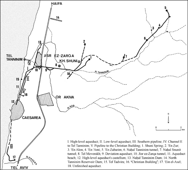
Channel B was replaced by channel C, which was built on top of the fill that blocked channel B and reached Caesarea c. 2.1 m higher. A section of the course of channel C, in the
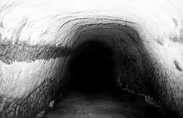
Channel B was built in the days of Hadrian (117–138 CE), as indicated by Latin inscriptions on the exposed side of the channel. The date of the construction of channels A and C does not appear in historical sources or inscriptions. It is generally agreed that channel A was built in Herod’s time, but its omission by Josephus in his description of the construction of Caesarea, together with the quality of its plaster and the results of the archaeological excavations in the 1990s, support the view that it was built later, during the first century CE. Channels C and D were probably built in the fourth century CE, as is evidenced by an inscription from 385 CE found near the point where channel D rejoined the course of channel A.
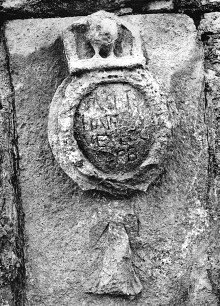
Channel A also supplied water through clay pipes to three imposing buildings (probably monasteries) from the Byzantine period located north of the city: one at Tel Tanninim, one at Tel Tadvira, and the “Christian Building.” The pipe leading to Tel Tanninim was later replaced by a masonry channel, which was partly supported by a wall of arches using the cement casing of the pipeline as its foundation. The “Christian Building” is located east of the low-level aqueduct and the clay pipe leading to it passed over the vault covering the aqueduct.
The Low-Level Aqueduct. The low-level aqueduct carried water from the
The Southern Conduit. A pipe was laid in the Byzantine period to carry water from ‘Ein el-Asal, in the lower course of
The Unfinished Aqueduct. This aqueduct, uncovered in Binyamina, was meant to carry water from the springs in the upper reaches of
The Lower Aqueduct. After the Arab conquest, when Caesarea lost its political and economic power and many of its inhabitants abandoned the city, the remaining population could not maintain the complicated system that brought water from outside the city and the system was neglected and ceased to function. During the Middle Ages, the needs of the inhabitants were met by installations near their homes: wells, springs near the shore, and cisterns that stored rainwater. The uncompleted lower aqueduct built in the tenth to eleventh centuries alongside the southern city wall to carry water from a spring near the shore (exposed in 1990, see above; see also
YOSEF PORATH
THE COMBINED CAESAREA EXPEDITIONS EXCAVATIONS
EXCAVATIONS
During the 1990s the face of ancient Caesarea underwent dramatic change as excavations on an unprecedented scale exposed much more of the site and resolved earlier puzzles and misconceptions. The Combined Caesarea Expeditions (CCE) organized in 1989 by A. Raban, of the Recanati Institute for Maritime Studies at the University of Haifa, and K. G. Holum, of the University of Maryland, continued work through much of the decade and, on a more limited scale, into the new millennium. In 1993, J. Patrich joined the CCE directorate on behalf of the University of Haifa. Inside the Old City, K. Holum directed excavations on the temple platform (area TP) and in a warehouse quarter north of the inner harbor (area LL). A. Raban led excavations at the presently land-locked inner harbor and its eastern quay (area I), and at two sites along the southern edge of the temple platform (areas Z and TPS). J. Patrich excavated south of the Crusader city in areas CC, NN, and KK. In area KK, he uncovered six warehouse units, while area CC, formerly field C of the Joint Expedition to Caesarea Maritima (JECM), contained a government complex that accommodated the Roman provincial procurator and later the governor of Byzantine Palestine. The CCE team also devoted effort to area CV, the western side of the area CC vaults, and its maritime unit conducted underwater excavations in the harbor.
EXCAVATION RESULTS
AREA LL. In area LL the CCE team renewed excavation of a quarter north of the inner harbor that L. Levine and E. Netzer had first explored in 1975–1976 and 1979. An east–west street through the quarter angled north of the orientation that Herod’s street grid required, so the alignment was thought to date from Straton’s Tower, but only a few soil layers and quarrying in the bedrock confirmed Hellenistic occupation. The street itself and its underlying drains underwent at least four phases of rebuilding between the first century CE and the later sixth, the ultimate phase consisting of a durable pavement of hard limestone slabs. At right angles to this street, extending southward toward a stone-built quay 23.7 m long on the inner harbor, stood a large warehouse (horreum). This structure measured 45 by 20 m and consisted of storage rooms arrayed on both sides of a central corridor, probably with a second story. Built originally in the late first century BCE as part of Herod’s port facilities, this warehouse was eventually dismantled sometime in the Roman period but was completely reconstructed in c. 400 CE on the same foundations. It then functioned until the 630s CE, the eve of the Muslim conquest, as part of the annona, the elaborate imperial apparatus that supplied grain, wine, and other commodities to the army and civil service. The CCE excavated three rooms of this warehouse, as well as part of the central corridor, down to the original lime plaster and tessellated floors.
The CCE team, like Levine and Netzer, discovered an abandonment layer lying upon the warehouse floors, a dense deposit of ceramic vessels for storage and transport, together with numerous coins dating no later than the 630s. Also from this layer came a set of gold ornaments that once decorated the belt of a senior military officer or civil official, a man named Stephanos to judge from the inscription on a belt buckle. Above this deposit, signs of building collapse appeared, including fallen structural blocks and burned wooden beams, and above the collapse was a layer of drifted sand, suggesting decades of utter desolation.
Like Levine and Netzer, the CCE dated the collapse and desolation in area LL to the period after the Muslim conquest of 640, and its reoccupation to the later seventh and eighth centuries. Area LL now became a domestic quarter of Muslim Caesarea, like others excavated recently inside the Old City in areas I and TP. Cross-walls blocked the former east–west limestone street, and the entire area was subdivided into about five dwelling units consisting of small rooms arranged around courtyards. The layout of the occupation had changed completely. Access was now apparently by narrow lanes from the north, west, and south. Floor levels were raised in two or three stages between c. 700 and 1000 CE, and beneath the courtyards and rooms, paved with kurkar slabs or mosaic pavements, the builders installed wells, cisterns, and the ubiquitous sinkpits for waste water. One former warehouse room now contained a large subterranean grain bin, lined with stone slabs. Although a century earlier in date, it was similar to grain bins from c. 1000 CE found next to prosperous Muslim dwellings throughout the Old City. The same domestic occupation apparently continued into the Crusader period. Of special interest was an apparent fortification tower that the CCE began excavating on the northwestern side of area LL, perhaps part of the coastal defenses of Muslim and Crusader Caesarea. What remains of the tower now measures 8 by 8 m, but only the northern, eastern, and southern walls still stand, and the entire western half may already have fallen into the sea. The walls are kurkar masonry c. 1 m thick, surviving as high as c. 8 m above sea level but with heavy buttresses at the corners that indicate considerable additional height. Flat but pointed arches pierce the northern and southern walls. The dating is still uncertain, but the architecture appears to be Islamic and may belong to the ninth or tenth century.
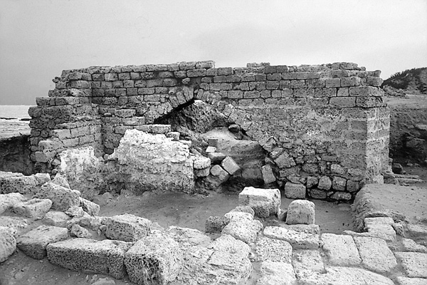
AREA TP. Area TP, the temple platform, rises to the east of the inner harbor. Josephus’ War I, 414 refers to it as a “hill of earth,” but actually it is a ridge of bedrock that Herod’s builders elevated and extended with retaining walls containing an earth fill, thus forming an esplanade large enough to accommodate a large temple and its surrounding porticoes. No trace of the porticoes exists, but they may be restored by analogy with Josephus’ description of the porticoes of the Temple Mount in Jerusalem. The temple platform’s full extent, far smaller than its Jerusalem counterpart, was about 90 m east–west and 100 m north–south, and the esplanade on top, presumably paved with stone slabs, lay at about 11.5 m above sea level. Upon it Caesarea’s most sacred religious buildings rose throughout the centuries, above the city’s essentially flat terrain.
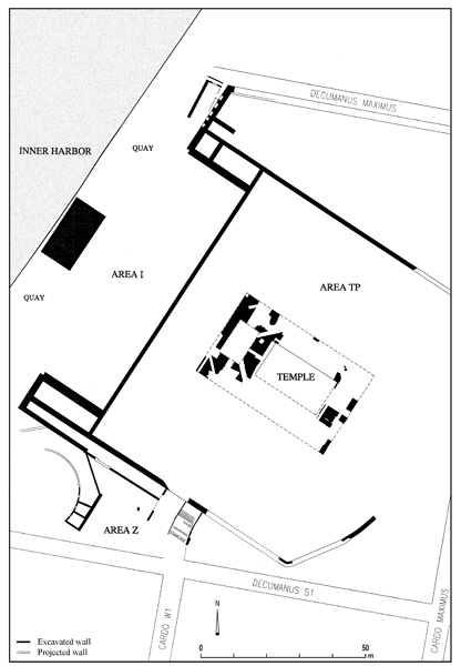
The inhabitants of Hellenistic Straton’s Tower, upon the ruins of which Herod built Caesarea, may already have worshiped on this very spot in a temple dedicated to Aphrodite as Isis-Hella-Agathe, but so far no archaeological evidence has come to light. The CCE did discover massive remains of Herod’s magnificent temple to Roma and Augustus, built when he founded the city in 20–10/9 BCE, and of an octagonal early Christian church constructed largely of its reused stones about 500 CE. After the church collapsed in the earthquake of 749 CE, the Muslims built the town’s Great Mosque somewhere nearby. Though mentioned by Muslim geographers, it has thus far not been identified in the remains. In the twelfth century, the Crusader conquerors built here the triple-apsed basilica of St. Peter that A. Negev cleared in the 1960s.
Subsequent stone robbing, as well as subterranean cisterns, sinkpits, wells, and deep foundations of later occupations (see below), destroyed most of the temple, the church, and other occupations, but enough fragments survived to recover the plans and elements of the superstructures. From the Hellenistic period (Straton’s Tower, third–second centuries BCE) only a few dissociated building stones came to light in the area TP excavations, along with a 1.9 m segment of a crude north–south retaining wall.
Ceramic evidence and coins confirm construction of the Roma and Augustus temple late in the first century BCE, and indeed, Josephus connects it with Herod’s original building campaign of 22–10/9 BCE. In his descriptions, the historian emphasizes the building’s exceptional scale and the colossal size of the statues of Roma and Augustus that it housed (War I, 414, cf. Antiq. XV, 339). The remains consist, first, of numerous fragments of the temple podium’s deep foundations. These were large blocks of the local kurkar sandstone joined together and to the underlying bedrock with a heavy dark gray mortar. Interior stones were irregular, but facing stones had been cut square, in some cases with bosses on the exterior subterranean faces. The foundations represent a podium 28.5 m wide north–south and 46.2 m long. The relatively narrow 2.8-m-wide foundation on the west would have accommodated a colonnade of six columns while the 7.8-m-wide foundations on the north, east, and south supported both a free-standing colonnade and the cella walls; so the temple was presumably peripteral and prostyle, i.e., it had a surrounding colonnade and a colonnaded porch on the west looking out over the harbor. Nothing more can be said of its plan, but many superstructure fragments have also survived, including bases, segments of column shafts, capitals, and entablature. These permit reconstruction of the Corinthian order, nearly 22 m high from the podium to the top of the architraves. Columns, architraves, and presumably other architectural elements had received a thick coat of hard, white stucco, with molded fluting in the case of the column shafts. This stucco protected the friable stone from rapid weathering and left the impression of marble construction. The height of the podium is unknown, but its upper surface must have been about 4.2 m higher than the level of the paved esplanade. With its pediments, therefore, Herod’s temple was indeed a building of majestic proportions, towering over 30 m above its surroundings.
Excavations in area Z on the south and southwest flanks of the temple platform exposed about 20 m of the southern retaining wall in this sector, 1.52 m wide, also dating from the Early Roman period (see below). Remains of a staircase also came to light, at least 6 m wide, that provided access to the temple platform from the south, in line with one of the north–south city streets. On the west, A. Negev had already exposed parts of the temple platform’s western retaining wall 17 m west of the temple podium. On this side, projecting arms to the north and south embraced the inner harbor and linked the temple platform with the harbor in one grand architectural conception. Midway between these projecting arms, exactly on the temple’s centerline and just inside the inner harbor quay, the excavators discovered a massive foundation of masonry and poured concrete, 9.4 m east–west and 20 m north–south, likewise Early Roman in date, interpreted as the foundation of the cult altar. Upon this altar the priests would have sacrificed bulls and other animals to Roma and Augustus during periodic festivals. In the space between this foundation and the western retaining wall a broad staircase presumably provided access from the inner harbor quay to the levels of the temple platform esplanade and of the temple podium itself. So far, however, the excavations have yielded no trace of this staircase.
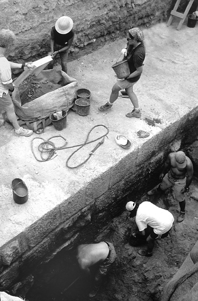
The temple to Roma and Augustus appears to have survived more than four centuries, though cultic activity presumably ceased during the fourth century CE, when Caesarea and the Empire as a whole adopted Christianity. The striking archaeological evidence both for the building’s longevity and for its destruction c. 400 CE consisted of large detached segments of the molded stucco coating of a column uncovered in north–south alignment with fragments of the associated capital and the entablature. Apparently a standing column had collapsed northward and came to rest upon a soil fill at 11–11.5 m above sea level, where the paving stones of the esplanade had already been robbed. From the position of these fragments, buried in an early fifth-century layer as they had fallen, it is clear that the column still stood c. 400 CE, presumably with those adjacent to it, but the archaeologists could not determine whether the colonnade collapsed due to natural causes or was intentionally pulled down. Purposeful temple destruction at other cities during this period perhaps points in favor of the latter possibility. In any case, Herod’s temple was then systematically dismantled down to the lowest foundation courses, at 9.0–11.45 m above sea level, and its stones were taken for use in new construction.
The Intermediate Phase. The first phase of new construction dated no later than c. 450 CE. The builders buried the dismantled temple foundations in a fill that contained ceramics of the fourth and fifth centuries, creating a new occupation level at 11.5–12 m above sea level. Into this surface they dug the foundations for a new building or a building complex, oriented differently from the underlying temple and unrelated to it. The foundations, 60–70 cm wide, consisted of cobbles and fieldstones laid in
The Church Phase I. This desacralization lasted until c. 490, when Christian authorities constructed a new sacred building, a martyr church or martyrium, on the temple platform. Unfortunately, the team found no inscription identifying the martyr to whom the church was dedicated, but they did recover enough archaeological evidence to reconstruct much of the construction process and the building’s original design and history. It appears, first, that the church builders dismantled the intermediate building complex down to its foundations, recovered the stones for reuse in their own building, and then covered the entire building site with a fill that elevated the occupation level to c. 12.7 m above sea level. Curiously, they returned to the orientation of Herod’s temple, perhaps because, for purely technical reasons, they adopted, on the west, the deep foundations of the temple pronaos, to support the foundations of their own building. In plan the church foundations consisted of concentric octagons inscribed within concentric squares. The outer octagonal foundation, 39 m in diameter, was 65 cm wide and supported the outer walls of the church, while the heavier inner foundation, 1.1 m wide, supported an internal colonnade with corner piers separating the ambulatory and the central nave, together with an octagonal clerestory above it and a segmented hip roof or dome. These octagonal foundations comprised large kurkar blocks mortared together, many of which originated in Herod’s temple, and the circumscribed square foundations were of similar construction, the outer one measuring 50 m on each side. The square foundations represent square and rectangular side rooms intended for use as chapels or for storing liturgical vestments and vessels. They and the triangular corner spaces were all roofed, to judge from the absence of sub-floor drains for these rooms. Capacious vaulted cisterns on the west beneath the narthex and on the east did receive runoff from the building, but it came from the roofs of the octagon and the side rooms, through well-constructed downspouts attached to the interiors of the side room walls.
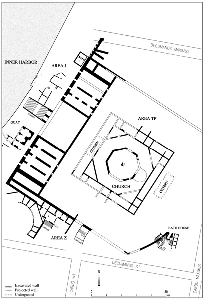
Unlike the temple, the church survived at floor level and even higher. Large patches of a pavement of large gray marble slabs came to light in the octagon; and in one of the side rooms on the east, already uncovered by A. Negev, the floor was opus sectile of red and cream stone slabs. Several superstructure blocks also remained in situ and lying about the site, some with clamp holes on their interiors and exteriors for attaching marble wall revetments. In the northern and southern walls of the outer octagon, jamb blocks and thresholds cut from reused marble column shafts revealed the positions of two doorways, and a single jamb indicated a third door opening into one of the side rooms from the northern entrance corridor. Inside the ambulatory, one of the eight corner piers and two square bases of the ambulatory colonnade remained in situ, demonstrating that the colonnade consisted originally of eight pairs of columns between corner piers, surmounted, of course, by Corinthian capitals, about eight of which survive, and probably by an arcade below the clerestory. In its original configuration the church apparently had no apse or raised bema for celebrating the eucharist, but a rectangular foundation below floor level in the exact center of the octagon revealed the position of the martyr shrine, perhaps in the form of a sarcophagus.
The Church Phase II. This configuration remained in service for only a short time, perhaps less than a decade, before the martyrium underwent conversion into a congregational church. Excavating on the eastern side of the building, beyond the eastern bay of the ambulatory colonnade, the archaeologists discovered substantial fragments of a second pavement level above the original pavement, the later one, too, composed of marble slabs. This pavement was positioned precisely between the two eastern corner piers, where two columns were evidently removed to accommodate it. The pavement fragments represented a newly installed bema, a raised platform for celebrating the eucharist that was semicircular on its eastern side and presumably surmounted by a semi-dome. Along the western side of this bema two steps were preserved, riveted with marble slabs, that led upward from the nave, and there were cuttings in column bases for the chancel screen that separated the bema from congregational space. No trace of the altar table has been identified, or of the synthronon for the clergy behind it, though these may confidently be assumed. Also uncovered was a marble disk 1.62 m in diameter with imprints of bases on its upper surface for small columns. This was likely the base of the church’s ambo, or preacher’s pulpit, which would have been positioned within the nave a short distance west of the bema. Hence in its second configuration, though apparently not in the first, the octagonal church accommodated the normal eucharistic liturgy, and in it the bishop or other clergy preached on occasion to the congregation.
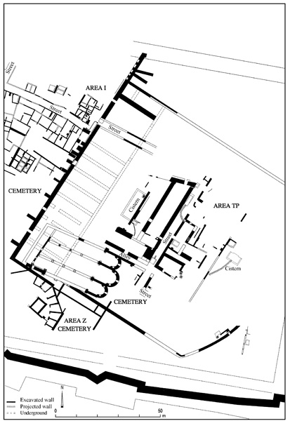
Construction of the octagonal church entailed modification of the temple platform itself. In area Z on the southern flank, the Herodian period staircase was renewed in this period and remained in service (see below). On the west, the space between the projecting arms of the original design had been filled in, perhaps already in the third century, with a series of vaulted substructures that supported a 20-m extension of the temple esplanade toward the west. About 500 CE, perhaps together with construction of the church, a new staircase, 9 m wide, was built to provide access between the inner harbor and this extended esplanade. Like the church, its fabric contained numerous fragments robbed from King Herod’s temple.
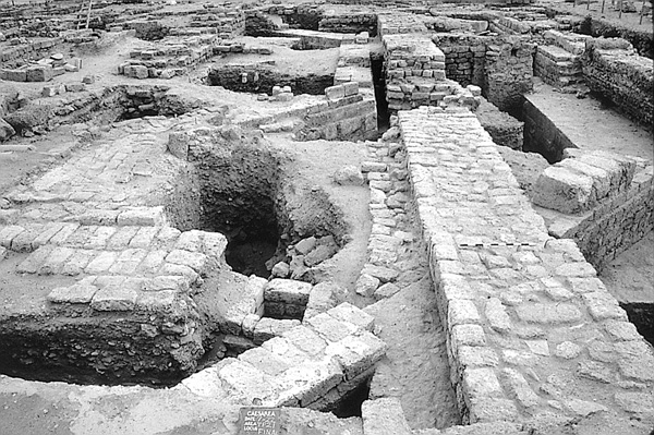
After the Muslim conquest of 640 CE, the octagonal church survived for a century or so, perhaps functioning during part of this time as a mosque. Indications of earthquake destruction suggest the building’s ultimate collapse in the major tremor of 749 CE, and indeed, numismatic and ceramic evidence prove the establishment of a new kind of occupation on the temple platform in the later eighth century. This was a domestic occupation of substantial townhouses built around courtyards, similar to those in area I to the west (see below), but in area TP little more than subterranean structures survived, mainly the cisterns, wells, sinkpits, and grain bins that destroyed much of the evidence for the underlying church and temple. Somewhere nearby was Caesarea’s Friday Mosque, known from literary sources, but no trace of it has come to light. The townhouses, but not the mosque, continued after the Crusader conquest of 1101 CE, when the local bishop built the surviving Church of St. Peter on the temple platform’s southwestern flank. Finally, in the thirteenth century, only a generation or two before Caesarea capitulated for the last time to the Egyptian Mamelukes, the Crusaders of Caesarea established a new monumental occupation with deep foundations that destroyed still more evidence of the underlying occupations. This was a series of broad and deep foundations, generally not mortared but laid with earth in the interstices, which probably supported great vaulted Crusader halls, as large as 30 by 10.5 m, which might have accommodated horsemen and their mounts. These flanked a 3.8-m-wide paved street that ran across the temple platform north to south and intersected a narrow alley, likewise paved, against the north side of the basilica. When excavations began, the remnants of the medieval domestic and monumental occupation left little sense of the grandiose ancient buildings—pagan temple and Christian church—that lay below.
KENNETH HOLUM
AREA TPS. Area TPS is located at the southeastern corner of the temple platform, just outside and adjacent to its curved retaining wall, which was founded on quarried bedrock and survived to its full height of over 4 m. The wall, 1.2 m thick, was built during the time of Herod and subsequently rebuilt some five centuries later. In the rebuilding phase, a door was installed in its lower part, with four stairs leading up to a rather narrow passageway (0.8 m wide). Inside the passageway, a 1.5-m-wide flight of stone-slab stairs ascended westward, adjacent to the inner side of the wall, up to the surface of the platform.
Access to this passage was through a small Byzantine bathhouse, preserved almost intact to its second story. Built around 500 CE, it is triangular in plan, its apex facing north. The eastern side was delimited by a thin partition wall that cancelled the colonnade along the western side of Caesarea’s cardo maximus, transforming it into a series of large water tanks. The main room of the bath, the caldarium, is only 4 by 2 m, with two external apses in each of its long walls containing skylights. The tepidarium to the east is half the size of the caldarium. The floors and walls of both rooms had once been paved with thin marble slabs. The frigidarium occupied the broader eastern side of a large dressing room that was furnished with marble benches and a niche with marble shelves. The complex was entered through a door in a thin partition wall from a paved courtyard to the west. The bathhouse went through several phases of modification, but continued to function well after the Islamic occupation of 640 CE, probably as a purification facility for Christian worshipers on their way to the octagonal church.
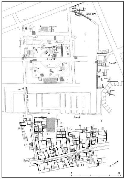
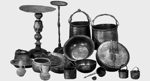
Toward the beginning of the eighth century, at least part of the bathhouse was converted into a fish-processing factory, as attested by some shallow basins and quantities of jars containing fish. The entire complex was covered by building materials fallen from the upper floors, most probably during the earthquake of January 18, 749 CE. Soon after that, the area was leveled to an elevation similar to that of the temple platform. Domestic structures were installed there during the Abbasid and the Fatimid eras. In the tenth century CE, a well was dug just inside the blocked entrance that once connected the bathhouse to the high platform. During construction of the walls of the rectangular well, the doorway was exposed and refurbished as a cache accessible through the well shaft. Sometime later, probably in the first half of the eleventh century, this cache was packed with a hoard of metal vessels, huge glass containers, and assorted jars and tableware—most likely the personal belongings of a metal shop owner. The unclaimed hoard was exposed during the 1995 excavations and it seems to resemble the one found at Tiberias several years later. During the Crusader period the area was paved with stone slabs and may have functioned as an open courtyard.
In addition to the discovery of the curved retaining wall of the raised temple platform, which was the main sacred place at Caesarea throughout its history, the small Byzantine bathhouse and the Fatimid hoard, another important archaeological discovery in area TPS is the evidence for the yet undocumented scope of destruction caused by the earthquake of 749, clearly attested by the positions of the fallen columns in the western courtyard.
AREA Z. Area Z lies south of the western half of the temple platform and the great Crusader church. The southern retaining wall of area TP, which marks the northern edge of the excavation area, and a massive retaining wall running perpendicular c. 18 m south of it are the only structural features in the area dating to Herod’s reign. The space between these walls contained an earth fill, while east of the eastern wall in area Z-2, a broad stone-slab staircase probably dating to the Herodian period was exposed that ascended to the temple platform from the south along a slightly curved line, as if to amend the overall layout of the sacred area and to conform to the line of the harbor of Sebastos and Caesarea’s streets.
The main architectural feature of area Z is a sigma complex, a series of trapezoid chambers opening onto what appears to have been a circular plaza and backed by a massive polygonal wall. A unique aspect of this complex is its longevity—the same chambers remained in use from the Early Roman period until the Crusader conquest of 1101 CE, nearly one millennium. Eight of the chambers, comprising just short of one quarter of a circle, were excavated in the 1987 and 1994 seasons. Each exhibited a distinct stratigraphic sequence and all were either workshops or storage chambers during the Roman and Byzantine periods. In later phases, during the Early Islamic era, some chambers included indoor wells and/or two-story shops. Unique among the rich assemblage of small finds, including metal and glass slags, is a group of over a dozen small marble slabs covered in Kufic incantation texts of the Umayyad period inscribed in black ink.
During the Abbasid era, following the replanning of the city after the great earthquake, the Byzantine tessellated square in front of the sigma complex was built-up with dwellings, wells, and septic pits. Later, during the Fatimid period, these buildings were partly leveled, and the northern half of the circular square was repaved in stone slabs.
Beyond the sigma complex, to the east, an additional subsidiary staircase, just over 3 m wide, was installed toward the end of the fifth century CE, leading toward the temple platform, probably in conjunction with the inauguration of the octagonal church there. A series of shops whose rear wall was the massive retaining wall of area TP occupied the elevated space on both sides of the staircase, above the sigma, replacing a Roman (second-century CE) bathhouse to the east. During the Crusader period this area was used as a burial ground, under the paved courtyard of the church.
AREA I. The flooded basin of the inner harbor of Sebastos and its perimeter have been studied and partly excavated as area I, by and large as a preliminary step toward renovation as a tourist attraction. This basin, detected by CAHEP in the late 70s, turned out to be twice as large as formerly surmised—over 200 m from north to south and c. 100 m from east to west, with water at one time covering an area of just over 18,000 sq m to an average depth of c. 2.5 m. At present, c. 90 percent of that area is landlocked and most of it was found to have been built-up by late antiquity. Approximately half of it was excavated down to the wave-carried sand fill. The excavations extended eastward over the harbor’s original quay for c. 20 m, up to the series of vaults that comprised the western façade of the temple platform. (On the results of the underwater excavations of the harbor, see below.) The stratigraphic study revealed 16 occupational phases and an additional 10 sub-phases, which were marked by CCE as follows:
16: Hellenistic period—mostly second century BCE, Straton’s Tower.
15: Herodian period—c. 16 BCE–6 CE.
14c: Early Roman A period—rule of the procurators, 6 CE–70 CE.
14b: Early Roman B period—to the Hadrianic period, c. 70–118 CE.
14a: Middle Roman A period—to the Severan period, c. 118–190 CE.
13b: Middle Roman B period—to the reign of Gallienus, c. 190–268 CE.
13a: Late Roman period—to the Constantines, c. 280–330 CE.
12b: Early Byzantine A period—to the time of Honorius, c. 330–400 CE.
12a: Early Byzantine B period—to the time of Anastasius I, c. 400–500 CE.
11: Middle Byzantine period—until after Justinian I, c. 500–565 CE.
10: Late Byzantine A period—to the reign of Phocas, c. 565–600 CE.
9: Late Byzantine B period—to the Islamic conquest, c. 600–640 CE.
8b: Transition period—early Caliphate, c. 640–700 CE.
8a: Umayyad period—first half of the eighth century CE.
7: Abbasid period—mid-eighth to mid-ninth centuries CE.
6: Tulunid, Ikhshidid, and Abbasid periods—mid-ninth to mid-tenth centuries CE.
5: Early Fatimid period—mostly the last three decades of the tenth century CE.
4: Middle Fatimid period—first half of the eleventh century CE.
3b: Late Fatimid period—second half of the eleventh century CE.
3a: First Crusader Kingdom and Ayyubid periods—twelfth century CE.
2: Second Crusader Kingdom and Mameluke periods—thirteenth century CE.
1: Bosnian village—late ninteenth–early twentieth centuries CE.
The Hellenistic Period (Stratum 16). The structural remains include a single, continuous course of slender ashlar headers, running parallel to the eastern quay of the inner basin, some 12 m to the east, probably a lower step leading up toward a raised quay that had been dismantled during Herod’s reign. Quantities of second-century BCE potsherds, including some coins and a dozen stamped handles of Rhodian and Koan wine amphoras, confirm that date. It seems that this harbor basin, which was protected from the open sea by a wall that terminates on its southern end in a round tower 12 m in diameter, similar to those exposed by the Italian expedition to the north, was somewhat larger than the Herodian one. Masonry with dressed margins like that of the western façade of the temple platform has been found at the back of the vaults and on their flanks, up to a height of c. 7 m above mean sea level. This leaves them some 5 m too low to have served as the western retainers of Herod’s temple platform. They may be related to an earlier Hellenistic building phase, as indicated by their similarity to the inner face of the original phase of the city wall along the north coast. The northern city wall was probably the one referred to in the Talmud as marking the boundary of the Land of Israel, the “city wall of Migdal Sar” (probably a literal translation of the Greek name Stratonis Pyrgos). This wall may have been the administrative demarcation between the royal harbor of Sebastos and the municipality of Caesarea until 70 CE.
The Herodian Period (Stratum 15). Two major structural complexes completed before Caesarea’s inauguration in 10 BCE should be attributed to the city’s initial phase. One comprised the eastern and northern segments of the quay that encircled the inner harbor basin. This quay replaced the earlier Hellenistic one almost all around the basin, except for the very northwestern end of it, which was exposed (in areas S and SE) down to its base courses at 2.4 m below mean sea level. It was found to be built of large headers of elongated kurkar blocks, in a typical Phoenician style. Elsewhere, the quay was exposed for a stretch of over 120 m along the eastern side of the basin and at the southern and northeastern turns of its course. The Herodian quay comprised a base wall made of form-casted pozzolana concrete that had been installed on a quarried ledge of the kurkar bedrock, at 1.2–2.3 m below mean sea level, up to the sea level of the time, with additional courses of ashlar headers as high as 1.6 m above mean sea level.
The second monumental structure is a 20-m-wide staircase that ascended from the quay eastward to the temple to Roma and Augustus. This structure was built of large, well-cut kurkar blocks as a raised platform that was reached through a vaulted passage at the back and 3-m-wide stairs ascending westward through an arched vomitorium. Once on the elevated pier, the pilgrims would turn eastward and climb up the broad “imperial” staircase. This concept of indirect passage on the way to a sacred shrine resembles the one at the Herodian Temple in Jerusalem (at the so-called Robinson’s Arch) and might have enabled better control over the visitors (and perhaps even the charging of entrance fees, either to the Temple, the royal harbor, or both). Only the central half of the staircase remained, after it had been trimmed to half its original width during the Byzantine era. The landing pier survived intact, comprised of a massive 10-by-20-m rectangle of pozzolana concrete with ashlar blocks around its perimeter.
An additional installation that belongs to the initial phase is the flushing channel constructed with pozzolana concrete that runs along the southern half of the eastern quay of the inner harbor basin. The channel began at the water’s edge of the south bay as a funnel-shaped structure, broad and shallow toward the incoming wash of the breakers that would flow into it and ascend to just over 1 m above mean sea level to a settling basin. From the settling basin, the sea water flowed in a channel running northward behind the quay and parallel to it, emptying into the inner harbor basin some 40 m from the northeastern corner of the harbor. This flushing channel went out of use sometime around 200 CE, when it was filled by silt that had been dredged from the bottom of the basin. It seems that at that point in time the flushing mechanism had lost its efficiency due to the advanced segmentation and subsidence of the harbor’s western moles.
The Early Roman Period (Stratum 14). This period may be divided into three sub-phases. During the first one (14c), the inner harbor appears to have operated much as it had since its inauguration, with some additional features. One such feature was a prominent sewer tunnel, installed at the back of the quay at the base of the western façade of the temple platform and running parallel to it, from north to south. It was large enough for internal maintenance work (1.2 by 0.6 m across) and covered by large, well-cut ashlar slabs. During this first sub-phase the western temple façade already comprised two sets of four parallel vaults at each side of the royal staircase, each 21 m long by 5.8 m wide with a maximum inner height of over 8 m. A nympheum was installed at the northern end of this façade, facing the inner basin and draining into the tunnel. The harbor was still separate from the city as a royal, or official unit, as may be deduced from Caesarea’s epithet on its coins issued by Agrippa I and by Nero: “…By the harbor of Sebastos.”
The second sub-phase followed the First Jewish Revolt and the promotion of Caesarea to the status of colonia prima. Though the city continued to flourish as the metropolis of the Roman province, the harbor had begun to fall into a state of disrepair. There is archaeological and sedimentological evidence to indicate that its main moles had lost coherence toward the end of the first century CE: merchantmen foundered over the collapsed segments of these features and the surge into the harbor basin piled sand deposits within the inner basin (see below, Underwater Excavations). Some alterations were made during that sub-phase within the vaulted chambers of the western façade of the temple platform. Their original function may have been altered from storage facilities for naval units to storage facilities for commercial goods.
The main feature added during the third sub-phase was a platform or quay, comprised of loosely laid large ashlars that protruded from the eastern quay c. 8 m into the inner basin. This platform is 26 m wide, aligned with the royal staircase (c. 3 m wider than the staircase on each side). It was laid over deposits that cover the rocky floor of the basin to a depth of 2.2 m below mean sea level. It was held in place by a compacted pozzolana concrete matrix that was laid by hand (the fingerprints of the masons are still visible). A narrow staircase was added to the western front of the platform, descending southward to the rocky bottom of the harbor basin. Another, circular, flight of stairs was constructed at the northeastern corner of that platform, also leading down to the bottom of the basin. In view of the fact that the water level at that time was somewhat higher than present-day mean sea level, one may wonder how that complex was constructed and for what purpose. This additional mole may have served as an extended landing for the royal staircase, provided that the staircase was modified to ascend directly from the waterfront to the level of the temple. For the time being, the magnificent complex remains enigmatic.
The Middle and Late Roman Periods (Stratum 13). Not much has survived of the structural elements datable to this period within the area of the inner harbor basin and the western façade of the temple platform. Modifications were made within at least some of the vaulted chambers, including renovation of the vaulted roofs and portions of the side walls. Some of the passages connecting these chambers were blocked and their openings to the west were closed by thin partition walls, furnished with small rectangular doorways. During this period, some vaults appear to have been subdivided and wooden galleries were added, turning the storage compartments into two-story complexes.
The stratigraphy of the sediments within the inner basin indicates that most of its southeastern half went through a rather rapid process of silting by wave-borne sand arriving not only through the mostly subsided western mole of the main harbor, but also through a breach in the southern sea-wall. The flushing channels went out of use and were intentionally filled with marine sediments and covered by the new paving of the eastern quay. It seems that the breach in the southeastern side of the basin provided a constant flow of sea water that created a navigable channel through which small craft could approach the added protruding quay from the west. Yet, in most areas within the basin the force of the incoming waves had deposited sand bars, at the lee of which were stagnant hollows, mostly detached from the sea and inundated with brackish water. These hollows were used as terminals and dumping places for the urban sewer network. An extensive and compacted layer, over 1.5 m thick, which comprised almost pure, non-oxidized organic materials, attests to that use. Probably sometime during this period the Roman nympheum at the northwestern edge of the temple platform ceased to be used and was replaced by a new nympheum constructed around the corner, to the east of the old nympheum, facing north toward the main decumanus.
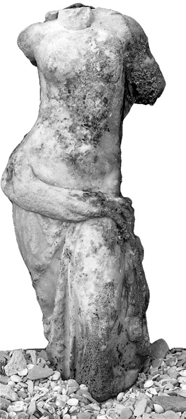
The Early Byzantine Period (Stratum 12). The era of Constantine may have witnessed the end of the pagan shrine on the temple platform and its eventual replacement by a Christian one, perhaps the martyrium shrine of St. Procopius referred to by Malalas as having been set on fire during the first Samaritan revolt in 472 CE. During this period, the inner harbor continued to be silted and lost any maritime function. Use of the western vaults for storage appears to have been discontinued and the chambers were turned into shops. In front of the two southernmost ones, a monumental structure was erected, the surviving elements of which include only a few scattered segments of ashlar stairs and five column bases from a stoa, or a broad portico of Ionic order. A rather typical element in the construction of this period is the extensive use of loam-based mortar as a binding material for ashlar courses and for strengthening plaster floors. The only well-attested features that belong to the later phase of this period are a series of sewer and drainage channels that were installed along and across the former eastern quay, draining the top of the vaulted façade and the chambers westward toward the silted basin of the inner harbor.
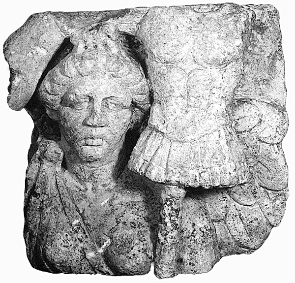
The Middle Byzantine Period (Stratum 11). The middle of the Byzantine period witnessed a major renovation of public monuments and large-scale building projects, primarily of monuments and urban facilities, probably under the imperial sponsorship of either Diocletian and/or Anastasius I. The central area between the subsided and silted harbor and the temple platform benefited most from these efforts. The former religious shrine(s) on the temple platform were replaced by the magnificent complex of the octagonal church on the renovated platform. The staircase leading up to it from the cardo to the south was rebuilt and two new staircases were created, one through a bathhouse in the southeast and the other ascending from a newly paved landing platform to the west, which trimmed the previously existing Herodian staircase to half its original width (10 m versus 20 m). This ashlar-paved platform covered the area to the north of the western staircase, the entire space west of the temple platform, and up to c. 1 m beyond the former quay with 0.8-m-wide stairs descending northward to what appears to have once been an inundated garden. A segmented pavement leading from the bottom of the stairs and comprised of short sections of reused column drums was installed in the muddy ground of that garden. The protruding platform of the quay added in front of the broad western staircase was altered by the reduction of its elevation to just below the sea level of that time and the construction of a perimeter wall around it, up to the elevation of the new platform, 1.8 m above mean sea level. This confined rectangle was flooded by ground water (with sedimentological evidence for repeated transgressions of sea water), creating a reflecting pool. Half a dozen mooring posts installed along the former quay, all marble or granite column shafts in secondary use, were trimmed down to the level of the new platform.
Beyond the western staircase to the south, the platform was much narrower—3 to 4 m at most—from the edge of the former quay to a series of shops that were built in front of the western façade of the temple platform. The vaults of that façade were renovated and their side walls were coated with white lime plaster bearing fingerprints of the ancient workmen. An additional flight of stairs leading down to the silted harbor basin, c. 2 m wide, was incorporated at the southern end of the quay. That basin was restored along its southern edge by a 1.2-m-wide wall that started 3 m west of the eastern quay and extended westward c. 100 m, up to the lee side of the rocky promontory of the so-called “harbor citadel.” This massive wall rested upon a series of reused column shafts that were imbedded in the non-consolidated, wave-carried beach sediments. The line of the wall was later rebuilt as the Islamic and Crusader period fortifications.
The Late Byzantine Period (Stratum 10). Toward the middle of the sixth century CE, the waterfront of Caesarea and its partly renovated harbor appear to have suffered a series of tectonic upheavals that included not only severe earthquakes but also tsunamis. The damage is clearly observed in wave-carried depositions within the “reflecting pool” and its surroundings. These accumulations caused the eventual demise of all the former complexes, which were replaced, toward the later part of that century, by new ones. The paved platform to the north of the great staircase was used as a base for a series of shops and small factories, including a large iron smelting kiln. Wells and cisterns were incorporated in these complexes for the first time, either as additional or alternate sources of fresh water to the high-level aqueducts. Some of these complexes extended westward over the now excessive sand deposits covering the inner basin. Most of the new floors were tessellated, laid upon a thick compact layer of orange-colored lime plaster. A mosaic floor, decorated with an inscribed medallion praising the “orthodox” was incorporated in one of these floors, laid over the northern part of the “reflecting pool.” A major new complex to the south of the staircase included a bathhouse with apsidal niches to the east and a small latrine in front of it, at its southwestern corner. Various small shops occupied the area further south, along the entire western side of area TP. All these units were entered from the west, while those at the north had access via an alley that extended eastward from the north–south promenade along the edge of the former quay. Within that alley, a springhouse was installed with stairs leading down to it.
The End of the Byzantine Period (Stratum 9). This period, which is regarded as contemporary with the early seventh-century CE Persian occupation and the erstwhile economic and political decline of Caesarea through these hard times, witnessed an apparent massive “privatization” of urban planning, at least in the central area in front of area TP. No measures were taken to protect the long silted-up inner basin from occasional sea transgressions, which hampered any attempts to use its area for “terrestrial” purposes. The better-protected space above the former quay and the western façade of area TP continued to be utilized as a commercial venue, with constant alterations in shops and workshops. In almost all the rooms and courtyards, the floors were now paved with simple coarse white tesserae laid in diagonal bands surrounded by a frame of 3–4 rows. The bathhouse went out of use as such and its apsidal complex was altered for another use. The public latrine was put into disuse as well. A typical component in the mosaic floors of most of the shops and courtyards were large dolia used as draining devices installed deep in the ground. Though not protected, the “beach” in front of the eastern quay appears to have been used during this period as a sort of open market place, with stabilized, packed floors, low ashlar walls, and shallow wells.
The Transition between the Late Byzantine and Early Islamic Periods (Stratum 8b). A sub-phase between the late Byzantine and Early Islamic periods is documented in area I by additional beach deposits and some alterations in the workshops located in the space between the former quay and the western side of area TP. The new Arab settlers retained and continued using most of the Byzantine structures for their own purposes. They installed a lime kiln under the vaulted passage at the back of the western staircase. Another kiln, for smelting iron, was installed in the southern vaulted chambers of the western side of area TP. The Byzantine spring house and wells remained in use and several more were dug at the former quay. In general, this part of the city appears to have been a mixture of workshops, dwellings, and a market place at this time. Sometime toward the end of the seventh century CE, probably following the Byzantine seaborne raid of 675, the intermediate harbor basin was deliberately filled with quantities of building materials and broken pottery vessels. This was most probably done in order to hinder any attempts to use it for hostile naval operations.
The Umayyad Period (Stratum 8a). For the most part, features of the previous sub-phase continued in this period, with the style of buildings and their mosaic floors resembling those of the Byzantine era. An additional feature attributed to this sub-phase is the ashlar-paved street over the eastern part of the silted harbor basin, along the foot of the quay. The north–south Roman sewer tunnel under the staircase was blocked and its northern part was converted into a cistern, with access via a manhole in a mosaic-paved courtyard. The quantities of pig bones found in garbage pits may indicate that many of the inhabitants were Christians. There are indications that the octagonal church at the center of the temple platform may have remained standing, probably functioning as such until the end of this period.
The Abbasid Period (Stratum 7). There is ample evidence for large-scale damage during this period, including a score of collapsed structures, most probably the result of the well-documented earthquake of 749 CE. Besides the octagonal church and its western façade, most of the buildings west of area TP were damaged beyond repair. This quake was by far the most traumatic in the history of the city, at least from an urban plan standpoint, until its final demise in 1293 CE. It is not clear when the city was rebuilt, but around the beginning of the ninth century, an entirely new layout emerged, with only minimal consideration of or adaptation to the former street pattern, sewer system, and other public infrastructure. The new plan did, however, retain the notion of a proper urban master plan, with streets dividing the built-up area into insulae.
The area west of area TP was leveled-off at a higher elevation, considerably higher than the massive debris of the ruined city, including the former harbor basin. It seems that a seawall was installed along the waterfront, in order to protect that silted-up area from occasional marine transgression. Three streets led from that area eastward, one ascending to the southern side of the temple platform and two on its sides. The eastern quay disappeared below the new structures, which included courtyard houses, each furnished with at least one well and several rectangular septic pits dug in the sand, retained by roughly laid ashlar walls, and covered by large stone slabs. The streets ran north–south or east–west, but their orientation and spacing were uneven. Instead of the typical right-angle junctions of the classical orthogonal plan, the Abbasid streets were staggered, creating small rectangular plazas at the intersections of cross streets. Adjacent to the dwellings, facing the streets, were shops whose drainage emptied into channels at the center of the unpaved streets. Industrial facilities were mostly at the base of the western façade of the temple platform and in the partly collapsed vaults. Among these were at least five iron-smelting kilns and a fish-canning factory that processed mostly fresh-water Tilapia (St. Peter’s Fish).
During this sub-phase, probably as part of the urban renewal, the western part of the intermediate harbor basin was dredged in order to refurbish it for maritime activity. The dredged material was carried away and dumped along the shore south of the new city, burying much of the area in front of the Herodian theater under several meters of sand mixed with marine-encrusted debris and artifacts. The overall size of the Abbasid city is unknown, but it is quite clear from the archaeological data unearthed so far that its southern limit was approximately at the line of the southern Crusader city wall; its eastern side extended east of the Byzantine esplanade excavated by S. Yeivin; and its northern extended beyond the early fortification wall with the round towers. Irrigation facilities of this period extend much farther, mainly to the east.
The Tulunid, Ikhshidid, and Abbasid Periods (Stratum 6). The urban plan was upgraded during this period. At least part of the built-up area was protected by a fortification wall with three gates, to the east, south, and north. The streets were furnished with sub-surface drainage channels and paved with stone slabs. Their raised elevation necessitated raising floors within residences and shops by more than half a meter. Some of the residential units were enlarged, generally by the joining of two units together. In most of the buildings constructed around a central courtyard, an upper story was added over the vaulted ceiling of the lower story. The piers and pilasters supporting these vaults attest to reconstruction. The improved drainage system included clay pipes that conducted the rainwater from the roofs. The number of cesspits, septic pits, and wells increased. Most of the floors in rooms and courtyards were paved with well-cut rectangular stone slabs that covered the drainage channels. The variable gradient of the streets’ drainage channels indicates that their runoff was always channeled into underground sinkpits through which the water filtered back to the ground-water table rather than to sea. The material culture of the period indicates an increase in imported pottery, mostly fine ware from Egypt. Yet, the small quantity of jars and other containers and the absence of imported containers may indicate that the foreign trade of Caesarea during this period did not include liquid agricultural products such as oil and wine. The area to the south of the city wall was designated as a graveyard and contained rather simple burials in which the deceased were covered by a layer of seashells.
The Early Fatimid Period (Stratum 5). The last decades of the tenth century CE seem to have been the most prosperous era of Early Islamic Caesarea, at least judging by the archaeological remains encountered in area I. The overall plan of the city remained unchanged, with significant improvements and additional elements: the subterranean hydraulic installations were perfected so as to administer water of different qualities in separate systems. Large vaulted plastered cisterns were installed under private courtyards shared by two neighboring dwelling complexes and were filled with rainwater from the roofs only. Clay pipes collected the rainwater in small settling basins before it flowed into the cisterns, where it was stored for drinking and cooking. The run-off from the courtyards and the streets would drain into sinkpits and eventually filter down to the water table. Wells, usually two or three for each dwelling complex (at depths of just over 2 m below floor level), supplied non-potable water for other household uses. The domestic sewers terminated in sealed septic pits, while public sewage was carried to the sea via a special drainage system.
All the kilns and other industries in the area ceased functioning during this period and appear to have been moved elsewhere, out of the residential quarter. Subterranean storage bins—rectangular chambers lined with ashlar slabs (up to the vaulted roofing)—were added to most of the dwelling units. Most had mosaic floors with a shallow hemispheric recess in the center. These chambers, installed in groups of two, four, six, or even more, varied in size and depth, having a volume of several cubic meters each. Their design and technical features replicate almost exactly those of the late Byzantine city, four centuries earlier. Such bins were installed within the dwelling complex, always in the wing adjacent to the street. It is quite obvious that their large capacity was intended to meet storage needs for export of a variety of agricultural products (wheat, lentils, olive oil, and perhaps black pepper). Imported artifacts including metalwork and fine ware, mostly from Egypt, are well represented in the surviving material culture of this period. A characteristic feature of the period was the frequent use of recycled tesserae and broken pieces of marble as components in opus sectile floors. In many cases these floors were laid over earlier, ashlar-paved surfaces.
The Middle Fatimid Period (Stratum 4). These were the troubled years of the first half of the eleventh century. The non-reclaimed hoards, such as the one in area TPS and that found by A. Negev in the southernmost vault of the western façade of the temple platform, attest to these years of public disorder and political unrest. The archaeological remains of this phase indicate considerable deterioration of urban life. Most, if not all, the subterranean storage bins ceased to be used, were partly robbed of their ashlar slabs and turned into garbage dumps. The mosaic floors were replaced by simpler ones of either plaster or stone slabs. Some of the drainage channels collapsed; others ceased to be properly maintained and became blocked by dirt and sediments. However, the imported Egyptian fine ware continued to be utilized, as did Egyptian metalwork and large imported jars and amphorae.
The Late Fatimid Period (Stratum 3b) and the First Crusader Kingdom (Stratum 3a). The archaeological data unearthed in areas I, TP, and elsewhere within the Crusader city does not enable a clear distinction between the Late Fatimid period and the First Crusader Kingdom, either in the architectural sequence, or the material culture and pottery types. The second half of the eleventh century witnessed a considerable urban recovery and renewed municipal attempts to restore public facilities such as streets, drainage, and the systematic collection of rainwater, so as to return to the standards attained during the earlier Fatimid period (stratum 5). The tessellated opus sectile floors were back in vogue, this time also in open courtyards and around well-heads and cistern cap-stones, and were often made of hollowed-out Byzantine marble column bases in secondary use. Column shafts were split in half for use as thresholds of doors in shops and residential units. New vaulted cesspits replaced the old clogged ones. The process of renovation and improved maintenance appears to have continued well into the twelfth century, not visibly affected by the Crusader occupation of 1101. Pottery also reflects a continuation of the Late Fatimid style. The few alterations included the creation of a Christian cemetery with cist graves under the stone-paved churchyard in the southwestern corner of area TP, and the addition of some wells. The wells dug during the eleventh century related to a much higher water table than the present one, indicating that sea level was over half a meter higher than current mean sea level. The later wells, dug during the twelfth century, related to a much lower water table.
The Second Crusader Kingdom (Stratum 2). The renewed occupation of Caesarea by the Crusaders in 1191, not before the city was partly razed by Saladin, initiated a period of over 60 years during which the major building efforts were devoted to the fortification of the city, starting with the so-called “harbor citadel” and culminating in the renovation of the fortification walls by Louis IX. Construction efforts in area TP were rather extensive and included the large cathedrals on the southwestern side and some additional broad walls and public buildings on both sides of a north–south paved street. Most of the low area west of area TP, and specially its southern part, had been dismantled and the robbed building stones were used to construct the restored city walls. This robbed quarter was used as the western extension of the burial ground. Many cist burials were found in former drainage channels and in the floors of late Fatimid residences. The subsiding sea level of the thirteenth century caused eventual subsidence of the fresh-water table, which necessitated the deepening of existing wells and the digging of additional ones, mostly with round or broad rectangular shafts (unlike the square Early Islamic ones), to a considerable depth of c. 1 m below mean sea level. The material culture of the period was by and large European in style, including the typical medieval pottery types such as Proto-Maiolica, Cypriot sgraffito, Zeuxippus, Port St. Symeon, and slip-painted wares. Yet some local Mameluke types, including hand-made geometric painted vessels and Syrian frit ware, may attest to the extent of Crusader symbiosis with the Islamic population of the country up to the final demise of Caesarea in 1265.
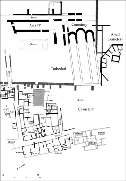
Conclusion. In addition to the well-documented prosperity of the city during the Roman and Byzantine periods, the archaeological excavations have revealed a period of urban prosperity at Caesarea during the Early Islamic period that is unattested in historical sources. The high standards of town planning, the awareness of hygiene implied by the monitoring of water quality, and the role of international trade in the Byzantine tradition that was perfected during the Abbasid and Fatimid regimes, are surprising in view of the infrequent references to Early Islamic Keisaria in historical sources. The true significance of the transition from polis to medina should therefore be reconsidered.
AVNER RABAN
AREAS CC, KK, AND NN. In 1993–1998, the University of Haifa conducted extensive annual excavations in three adjacent areas (CC, KK, and NN) south of the Crusader city of Caesarea. Shorter and more limited excavations were conducted in conjunction with development works in the years 2000 and 2001. Previously, four different expeditions had conducted excavations in these excavation areas: A. Negev excavated the northern part of area CC in 1961 on behalf of the Hebrew University; R. J. Bull and the JECM excavated most of area CC (their area C) during 12 summer seasons over the years 1971–1987, and also dug small probes in two other areas, named areas K and N; the American partners in the CCE under K. G. Holum and C. M. Lehman excavated the vaults in the western part of area CC (a strip they named CV), as well as the western part of area K during the summers of 1991–1995; and G. Blakeley and W. Bennet excavated vault 2 in area C as a separate project in the years 1991–1995.
Buildings and finds from the Hellenistic to the Crusader periods were uncovered in the new excavations. In all, nine strata and sub-strata were defined, representing major phases of construction, settlement, or destruction. In the areas excavated, urban life continued uninterrupted from the time of the city’s founding by Herod until the Muslim conquest of Caesarea. A number of Roman–Byzantine architectural complexes were uncovered in their entirety: the starting gates (carceres) of the Herodian hippo-stadium (in the western part of area KK), the Roman procurator’s palace (extending over all of area CC), and a Late Roman/Byzantine warehouse complex (extending over all of area KK). During the Hellenistic period the entire area served as a cemetery (burials in amphorae), as it did in the Abbasid, Fatimid, and Crusader periods (cist tombs and simple burials). At the end of the Byzantine and beginning of the Umayyad period, terraced gardens irrigated by well water conveyed in irrigation channels were installed on top of the abandoned and ruined buildings.
| Stratum | Period | Findings |
|---|---|---|
| VII | End of first century BCE, Herodian period | Herodian building projects; starting gates of the Herodian hippo-stadium |
| VI, V | First–fourth centuries CE, from the time of Herod’s heirs to the Late Roman period | Modifications in the hippo-stadium; in area KK two complexes that preceded the warehouses; in area CC buildings that preceded the vaults, followed by phases I and II of the Roman procurator’s palace constructed on top of the vaults |
| IVB | Fifth–sixth centuries CE, the Byzantine period | Warehouse complex in area KK; the Byzantine governor’s palace (praetorium) in areas CC and NN |
| IVA | 634–641 CE, the seven-year siege leading to the Arab conquest | End of the urban era: the Byzantine buildings (warehouses in area KK and the praetorium in areas CC and NN) are abandoned |
| IIIB | 634–641 CE, end of the Byzantine period | A layer of rubble inside the abandoned Byzantine buildings |
| IIIA | 634–650 CE, transition from the Byzantine to the Early Arab period | The siege and the first few years after the Arab conquest; wells were dug and terraced; irrigated gardens were installed on top of the ruins of the Byzantine buildings; a layer of garden soil rich in organic waste was deposited |
| II | 700–800 CE, the Umayyad–Abbasid period | Sand layer with eroded Byzantine potsherds, perhaps the result of dredging operations in the silted harbor |
| I | The Abbasid–Ottoman period | Cemetery in areas CC, KK, and NN |
Streets and Urban Planning. The city’s orthogonal plan was established in the days of Herod and remained basically unchanged until the end of the Byzantine period. Excavation areas CC, KK, and NN extend over parts of four city blocks (insulae) on either side of cardo W1, which connects the Roman temple platform in the north with the Herodian theater in the south. The dimensions of the city blocks in this part of the city are 90 by 65 m. The northwestern block (area CC) is bounded on the south by decumanus S2. This block, 65 by 55 m, was damaged by the construction of the Crusader moat and wall on the north, and by sea waves on the west. The dimensions of area KK in the southwestern block are 75 by 40 m. Its southern part is located inside the IAA’s excavation area. Excavated to the east of cardo W1 was area NN, comprising a 92-m-long strip of varying width (11 m in the south and 22 m in the north).
Cardo W1 and decumanus S2 were not colonnaded streets. The three columns that the JECM placed at the entrance to the “tax revenue office” of the Byzantine governor’s palace probably do not belong there; rather, it would seem that originally at the entrance there was a row of piers supporting an arcade. Two additional porticos bounded by arch-bearing piers were located on the south, near the intersection, on either side of the cardo. The surviving streets are paved with slabs of limestone or the local kurkar, with sewers running beneath them.
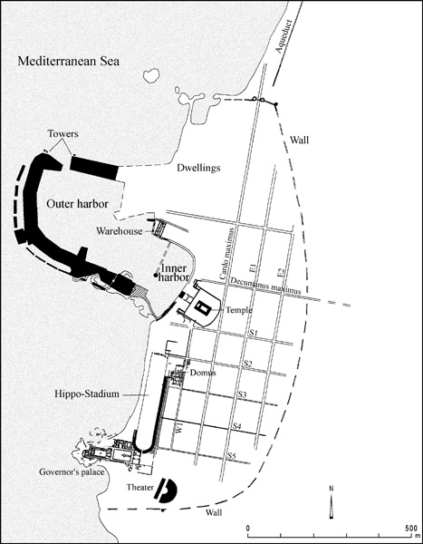
Decumanus S2 extends westward 56 m past its intersection with cardo W1 to the northwest corner of warehouse II. Its width ranges from 4.25 to 4.7 m. At the western end it widens into a paved piazza preserved for 17.1 m from east to west and for 10.5 m from north to south. The street’s paving stones, which have been preserved in their entirety, are of limestone, except for two rows of kurkar slabs. Underneath the street runs a sewer with six stone-covered manholes located at 7 to 12 m intervals. Two additional manholes were found in the piazza. Two clay pipe gutters (18 and 22 cm wide respectively) and secondary sewers leading into the main sewer drained the buildings on either side of the street. The paving of the intersection continues that of the decumanus (rather than the cardo pavement). Near the intersection a number of marble shafts were found, as well as a marble Corinthian capital with a cross on one face of its abacus, dateable to the end of the fifth or the beginning of the sixth century CE. A 9-m-long section of the decumanus was excavated east of the intersection. Its width there is 4.6 m. Like the longer section west of the intersection, it too is paved with thick limestone slabs.
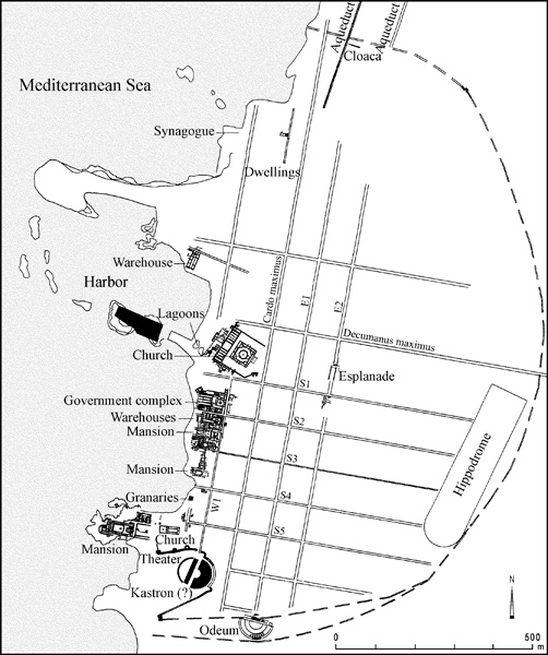
Cardo W1 was exposed for a length of 39 m between areas KK and NN. Its width there is 4.9 m. Most of its upper paving stones had been removed, except for a small section near the intersection. Its state of preservation is much better at the intersection and northward. Soundings in the southern section exposed three earlier street levels: in its earliest phase, dating from Herod’s days, the street was paved with compacted crushed kurkar; the second level was paved with compressed kurkar gravel and delineated with high curbstones with raised margins on either side; the third level was paved with thick slabs of limestone; and the fourth (uppermost) level was paved with kurkar slabs. A lead pipe underneath the third level, running on the western side of the street, was replaced by a clay pipe along the eastern side of the street in the fourth phase. Four manholes that were found along this section of the cardo also belong to this last phase. The buildings on either side of the street were drained by gutters and secondary sewers flowing into the main sewer. This sewer had two construction phases: the first dates to the initial construction of the street; it underwent repairs when the second level of paving was laid. The sewer’s second phase is contemporaneous with the limestone pavement; it was repaired when the pavement was replaced by kurkar slabs.
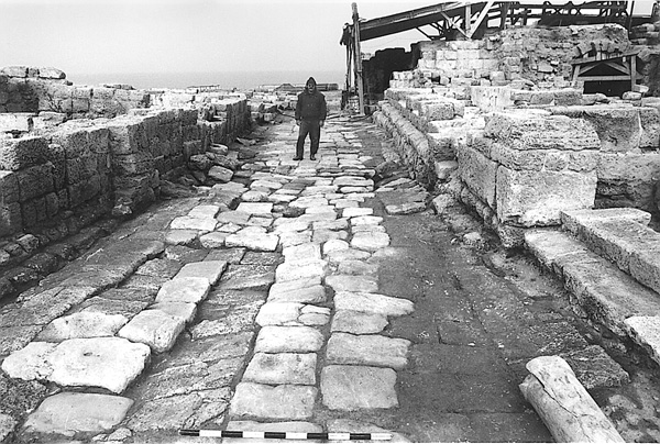
The northern part of cardo W1 (running between areas CC and NN), with a well-preserved kurkar pavement, had already been exposed nearly in its entirety, for a length of 53 m, by the JECM in the 1970s and 1980s. Its width there is 5 m. This section of the cardo contains five manholes. The paving stones were laid diagonally, except for the central part between the two staircases leading up to the Byzantine governor’s palace, where they were placed perpendicular to the direction of traffic. Here again, three earlier phases preceded the final Byzantine street level. The earliest phase, dating from Herod’s time, is of yellow kurkar; the second, dating from the third century CE, is of grayish crushed and beaten kurkar mixed with plaster; and the third phase, provisionally dated to the fourth century CE, is of kurkar slabs, most of which were found upside down (a few were found in situ, arranged diagonally). The main sewer predates the street’s second phase. It ceased to function at a later stage, being replaced by a shallow channel on a higher level during the street’s third phase. No water pipes, whether of lead or clay, were found along this section of the cardo, which rises gently from south to north.
The orthogonal layout of the streets and the sewers underneath accord well with Josephus’ account of the streets and sewage system which Herod built at Caesarea (War I, 413; Antiq. XV, 340).
The Starting Gates of the Herodian Hippo-Stadium. The entertainment structure built by Herod on the shore facing the sea, between his palace and the theater to the south and the harbor to the north, is referred to by Josephus (Antiq. XV, 341; War I, 415) as an amphitheater, which in his days meant an elongated arena surrounded by spectator seats (only later did this term come to denote an oval arena like the Colosseum in Rome). Elsewhere Josephus speaks of the great stadium in Caesarea (War II, 172; in Antiq. XVIII, 1, it is simply referred to as a stadium), which probably refers to the same Herodian structure located next to the Roman governor’s palace, where Herod’s palace once stood. The existence of starting gates (carceres) indicates that the facility was used for horse-racing as well as athletics. In fact, it was a multipurpose amusement facility, used for a variety of performances. Hunting scenes (venationes) and gladiatorial fights (munera gladiatorum) were among the different types of shows performed there from the time the facility was inaugurated by Herod in 10 BCE with games in honor of Augustus (Antiq. XVI, 136–141; War I, 415). Herod also decreed that such games, lasting for 15 days (Antiq. XVI, 140, in a Latin manuscript that predates the original Greek text), should be held there every four years. In 43 CE, King Agrippa sponsored the games (Antiq. XVIII, 343–350; Acts of the Apostles 12:20–23). Eventually these games came to be known as the “Isactian Games” (i.e., “of Actium”) in honor of Augustus’ famous naval victory over Marc Antony near that Greek city in 31 BCE. A rich repertoire of games also took place annually in association with the emperor’s cult.
The western part of area KK includes a 40-m-wide section of the race course—the arena—whose overall length was c. 301 m. Further to the south it is preserved to its entire width of 50.5 m. The original dimensions of the arena were thus c. 600 by 100 cubits of 50.5 cm each. At the arena’s northern end were found the starting gates for the horse races. These were built of kurkar, like all the other parts of the structure. The excavations unearthed the main entrance and all the gates east of it along a 30-m-wide section (from east to west). It is highly probable that the starting gates on the western side, which were eroded by the sea, were similarly constructed, giving an overall symmetrical layout.
After an early, temporary phase (phase 0) at an elevation of 1.6 m above sea level, which predated by five years the structure’s official inauguration (at an elevation of 2.2 m above sea level), three distinct groups of starting gates dating from different time periods were uncovered. The table below sums up the relevant data and finds.
In the Herodian period (phase I) there were five stalls on either side of a central gate. The shapes of the pairs of piers which separated the stalls make it possible to distinguish three sub-phases, each more monumental than its predecessor. The deep foundations of the phase I piers abolished earlier Herodian foundations (phase 0) that were constructed in a radial layout related to an arena level lower than that at which the structure was inaugurated. During this first informal phase there were only four stalls on either side of a central gate; it seems to be related to races held in honor of Marcus Agrippa, who visited Caesarea in 15 BCE, when the hippo-stadium was still under construction.
| Phase | Type of Gate and Façade Decoration | No. of Stalls | Date | Elevation of Arena (above sea level) |
|---|---|---|---|---|
| 0 | Wooden (?) superstructure | 4+4 |
15 BCE, visit of Marcus Agrippa | 1.60 m |
| Ia | Four-pier stalls on trapezoid foundations; decorated by sunken vertical band | 5+5 |
Herod; inaugurated in the celebrations of 10 BCE (according to Josephus) | 2.20 m |
| Ib | Four-pier stalls; the front piers shaped like two attached half columns; the back ones with rhombic cross-section; the stalls separated by wooden partitions | 5+5 |
2.20 m | |
| Ic | Four-pier stalls; the front piers more massive; a projecting vertical band on the façade; stalls separated by stone partitions | 5+5 |
After 42 or 43 CE, according to a coin of Agrippa I in the arena fill | 2.50 m |
| W100 | Built on top of the mostly torn down pillars of phase Ic; constructed of stones laid as headers | 66–70 CE; pottery characteristic of the end of the Second Temple period found within the wall | Built on top of arena level of 2.50 m; preserved to an elevation of 3.00 m | |
| II | Each stall bounded by a pair of elongated piers | 5+5 |
The reign of Trajan (98–117 CE) or the beginning of the reign of Hadrian (117–138 CE), according to a coin of Trajan found in the arena of this level | 3.20 m |
| III | Each stall bounded by a pair of elongated piers | 4+4 |
The reign of Septimius Severus or later, according to a coin of this emperor found in the arena of this level | 3.40 m |
On opposite sides of the foundation course of phase Ic (the latest Herodian phase) depressions were hewn (20 cm wide and as deep). These held the door hinges as well as the spring mechanism by which the stall doors opened. The stalls were between 3.3 and 3.6 m deep, with a width of 3.75–4.0 m. They were parallel to each other and to the arena’s longitudinal axis. However, each stall was located slightly to the north of the one east of it, so that a symmetrical façade was formed, slightly rounded relative to the longitudinal axis of the arena. During the Herodian period, the arena (particularly in the vicinity of the stalls) was raised so as to help the chariots accelerate from the gates.
The Herodian stalls were dismantled and their remnants covered by a massive wall (W100), which converted the arena into a large enclosure. Sherds from the end of the Second Temple period, including “Herodian” lamps, were found between the stones of this wall, providing clear evidence for dating the wall. This modification of the arena may be connected with the First Jewish Revolt against the Romans, which broke out in Caesarea in the year 66 CE. Titus might have used this enclosure to contain the Jewish prisoners of war in the winter after the end of the revolt in 70 CE (War VII, 20). Some time earlier, in October 70 CE, Titus celebrated his brother Domitian’s eighteenth birthday here, on which occasion he had over 2,500 Jewish prisoners slaughtered by fighting wild beasts or each other, or burnt at the stake, the kind of entertainment enjoyed by Romans at the time (War VII, 37–38).
When the games were renewed after the end of the First Jewish Revolt, the starting direction was changed to a “starting line” at the nearest turn (meta secunda) by the setting of the stalls somewhat radially, as was the regular layout of stalls in the Roman world. However, even in these phases, this narrow (50.5-m-wide) stadium apparently never possessed a continuous barrier wall (spina). When races took place, a makeshift partition could have been set up using poles or painted markings. Games, including athletic competitions, were held in this facility—the municipal stadium—during the second and third centuries CE as well, and as a result, no permanent partition was constructed there during the post-Herodian periods either.
No wall enclosing the stadium on the eastern side of the carceres has been found for phases I and II. Such a wall was only built later, over pier II.1, the easternmost pier of phase II, during the reign of Hadrian. During phases I and II this part of the stadium may have been enclosed by another wall farther to the east, which has yet to be uncovered.
A fragmentary relief (maximal dimensions: 60 by 45 cm) of a wing (belonging to an eagle or to Nike, goddess of victory) may have been part of a statue which decorated the starting gates. In addition, bronze fragments of a palm and the left arm of a slightly larger-than-life human statue were found. A strip of bronze joined to one of the statue’s fingers may be the remains of reins, and thus the statue itself might have depicted a charioteer holding reins, perhaps as part of a chariot group. The monumental proportions of the statue raise the possibility that it was set up on a high spot, perhaps over the central arch of phase II or III. Depictions of Nike, charioteers, and chariot groups were frequent motifs in the decoration of hippodromes.
Two worked-bone discs of the “theater ticket” type may have served as entrance tickets to the stadium. The obverse side of one disc shows a fist with one extended finger while the other depicts two fish. The reverse side shows the Roman numerals VIIII and ∆ IIII respectively, perhaps indicating block and seat numbers.
The Government Complex. Parts of the government complex had been excavated previously by a number of expeditions, but it was only definitively identified as the Roman procurator’s and Byzantine governor’s palace following the CCE excavations, when the entire structure was uncovered.
There were two complexes of government buildings in Caesarea. One was Herod’s promontory palace, which was taken over by the Roman governors from 6 CE, when Judea came under direct Roman rule after Herod’s son Archelaus was sent into exile. Until the First Jewish Revolt, the Roman governor of Judea was of equestrian rank. In the year 70, Judea’s administrative status was raised and a governor of senatorial rank was appointed, with the title of legatus augusti pro praetore. This governor was also the commander of the legion. It was the usual practice to send to imperial provinces of this rank a procurator, a representative of the emperor who managed the province’s financial affairs. For this procurator a second government complex was built in Caesarea. This complex was discovered in area CC, some 350 m north of the governor’s palace. In time, the procurator’s palace became the Byzantine governor’s palace (following the administrative reforms introduced by Diocletian and Constantine).
This government complex was located north of decumanus S2, near the sea shore. It covered the entire first city block to the south of the Crusader city, and apparently also the adjacent block to the east. The entire excavation area CC is included within it, as is the northern part of area NN. The northern part of the complex was damaged by the construction of the Crusader moat and wall, and the western part has been eroded by the sea. Latin and Greek inscriptions support the identification of the architectural complex unearthed here as an administrative center and even make it possible to ascribe definite functions to the complex’s various components. Many of the Latin inscriptions found here mention or refer explicitly to the Roman procurator.
The state of preservation of the structures in area CC is quite good. The western and southern part of the complex rests on 15 vaults, the majority of which were initially documented by the JECM; many of these vaults have been preserved in their entirety and even the structures above them have survived. The administrative center’s main conference and judicial hall, an east–west basilica-like structure whose southeastern corner has been preserved up to the second story level, was supported by four elongated 30 by 5 m vaults (nos. 1
No vaults were constructed on the eastern side (beyond vault 9 and along the cardo), since the ground gradually rises there from west to east. There too, a number of well-defined units survived: a central courtyard, a Byzantine structure that has been called the tax revenue office (see below) in the northeast, and a public latrine in the southeast. The government complex was reached from the cardo on the east by two identical staircases, one located at the northern end of the arcade of the latrine and the other at the southern end of the portico of the tax revenue office. The staircases were needed to span a 2.5-m difference in elevation between the cardo and the complex’s eastern courtyard. The section of cardo between the two staircases was paved in a parallel pattern rather than in the diagonal pattern used elsewhere, emphasizing the special character of this part of the cardo and of the adjoining city block. Below the center of the courtyard was a round, domed cistern. The courtyard suffered grievously at the hands of stone robbers: the paving stones, the surrounding walls, and the kurkar fill beneath the floor have been removed and the cistern has collapsed. Extant marble and kurkar column bases and the remnants of the walls indicate that the courtyard had columns on the west and perhaps on the east.
To the west of this courtyard and slightly higher lies another courtyard which surrounds a major hall—the “law court” or “hall of justice.” This was a large rectangular hall, of which only the southeastern corner has survived. Parallel to this corner, the corner of the stylobate on which the roof-bearing columns stood has also survived. The corner’s southern wall was built on top of the wall separating vaults 11 and 12, and its eastern wall, running perpendicular to the row of vaults, over a shallow arch. Supporting arches were also constructed inside the vaults. The course of the hall’s northern wall can only be identified by a robbers’ trench. This wall was built over the wall separating vaults 1 and 2. The location of the hall’s western wall is recognizable by the piers of the arches that supported it. The piers of one of these arches can be seen in vault 2 and those of the other in vault 11. Thus the entire outline of this basilical hall has been reconstructed, its dimensions being c. 18 by 13 m. Around the basilica three phases (I–III) can be discerned.
During phase I, the hall was surrounded on the north, east, and south by a reflecting pool. The façade, which has not survived, thus faced west. East of the pool a square fountain house was found, with stairs along its southern, western, and northern walls leading down to a fountain pool, the stairs paved with marble and the pool with a white mosaic. The water came in from the north through a lead pipe, a section of which was exposed.
In phase II, the reflecting pool was converted into an ornamental garden. For this purpose flat stones 8 cm high were placed on the pool floor, each stone to support the corners of four adjacent tiles. Over these tiles a layer of
During phases I and II there was a small latrine to the south of the fountain house (inside vault 54), which was accessible from the west through alley 3 and vault 19 and from the east through a staircase leading down into vault 54. The latrine seems to have served the officials employed in the courthouse and the offices adjacent to it. Members of the public would have used the public latrine located near the intersection of the cardo and decumanus.
During phase III, the entire area east of the hall was covered with a mosaic in a rhomboid pattern, creating a piazza. The fountain was buried underneath the mosaic floor, whose construction also involved the dismantling of the walls of the irrigation tank. It was during this phase that the façade of the hall was moved to the east, to face the mosaic-paved piazza.
The impressive dimensions of the hall and its central location within the block indicate that this was a public building. Fragments of a fifth-century CE legal inscription in Greek found in and around the block seem to indicate that the hall served as a civil court during all phases. The extensive remains to the north of the hall include a large apse, dated to the Byzantine period (see below), built over a rectangular hall with a mosaic floor and, adjoining it on the north and south, elongated corridors running east–west, also with mosaic floor. The southern wall of the southern corridor had five rectangular niches, of which the easternmost has been preserved in its entirety. Niches of this type usually contained wooden chests (armaria). The structure’s proximity to the law court makes it probable that it was an archive (tabularium) or a legal or financial library. A tabularium in Caesarea is mentioned in a Greek papyrus found in Egypt. The apsidal hall later constructed on top of the rectangular hall may also have been an archive or a library. South of the law court a series of chambers was found. These chambers, built over the vaults along the decumanus, may have belonged to the court officials and clerks.
The main purpose of the vaults, as mentioned above, was to serve as a substructure for the second story: the law court and the offices to the south of it. The vaults underwent a number of changes over time. Thus, vault 1 served as a small temple to Mithras (a Persian deity popular among Roman soldiers who distributed his cult throughout the Empire) for a time in the third century CE. This temple had already been uncovered by the JECM. Our excavation unearthed a spiral staircase and an entrance at the western end of the northern wall. These connected the vault and the temple in it with the upper level. The entrance was blocked at a later stage.
The public wing of the government complex extended over the unexcavated two-thirds of the block. The remaining third was damaged by the Crusader moat and wall. It was large enough to accommodate the private wing or residential area that probably consisted, in addition to the living quarters themselves, of courtyards, gardens, and additional halls. In this wing only a bathhouse, whose remains date mainly from the Byzantine period, was partially uncovered (see below).
The palace of the Roman financial procurator later served as the office and residence of the Byzantine governor. Phases II and III date to the Byzantine period. The Greek inscriptions (some discovered previously by the JECM, others found in our excavation) indicate that justice and tax collection—the two main functions of the Byzantine governor and his administration—were carried out from this compound.
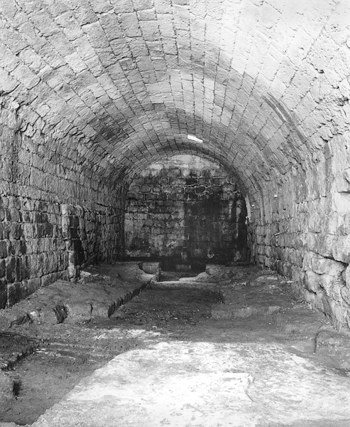
The tax revenue office, which was constructed in the Byzantine period in the northeastern sector of the palace, consisted of seven rooms around a central hall. Each room had several superimposed floors of mosaic, marble, and stone, and some contained Greek inscriptions. This sector was excavated and identified by the JECM. During its earliest phase, there was a single entrance from the cardo; the other rooms were entered from the central hall. Two rooms with stone benches, one on the northeast and the other on the southeast, served as reception rooms. Later a new entrance was built in the east wall of the northeastern reception room; the previous entrance was blocked, an additional reception room was built to the south of it, inside the central hall, and the entrance to what remained of the hall was moved further south. The floors of all the rooms were raised a number of times. All these changes indicate that an attempt was made to regulate and control a growing number of individuals served by the imperial bureaucracy, a typical feature of Byzantine administrative practice.
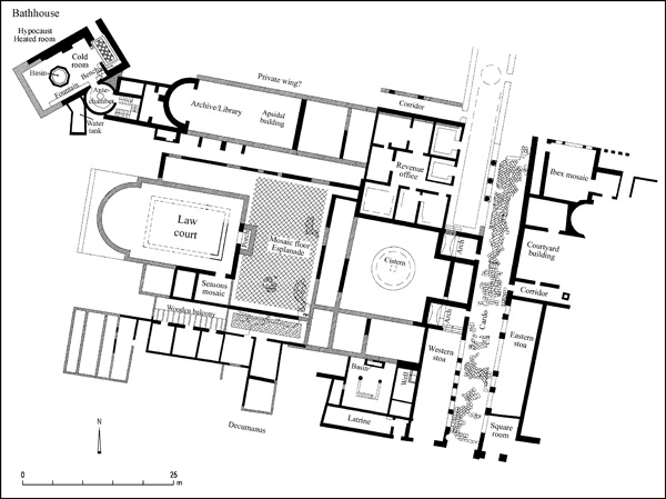
The tax revenue office complex was fronted by a portico with a mosaic floor, separated from the cardo by a row of piers supporting an arcade (as mentioned, the three columns reerected there seem to belong elsewhere). Three superimposed mosaic floors were found in the portico. On the earliest of these, a Greek inscription was found in which low ranking officials of “deputy assistant” rank are mentioned. The names of other officials, including scribes and an accountant, appear in inscriptions found by the JECM. This was, thus, an office of the imperial administration. In both reception rooms there was an inscription whose text, commending obedience to authority, is taken from Romans 13:3: “Wilt thou then not be afraid of the power? Do that which is good, and thou shalt have praise of the same.”
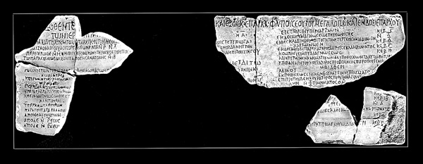
To the southeast, along the cardo, a stoa with a mosaic floor was found. It was separated from the cardo by an arcade resting on square piers. Between the piers there was probably a wooden screen. At either end of the stoa, facing the cardo, two small fountains flowed from small niches, one near the intersection and the other at the northern end of the stoa. To the west of the stoa a public latrine was uncovered, entered at its eastern end from the decumanus. In an earlier phase the latrine had extended further to the north and was double in area.
North of the phase III law court stood an apsidal two-story structure, which the JECM excavated. Impressive remains of the ground floor (serving as a substructure for the floor above) were found, including a massive apse and supporting piers. The second floor was reached by means of a staircase on the eastern side of the building, behind the apse. The staircase was approached through a circular antechamber with a mosaic floor bearing a Greek acclamatory inscription to Andreas, governor of the province of Palestine. The apsidal structure was erected in the sixth century CE, and may have served as an archive or library, like the rectangular Roman building which preceded it (see above), but the possibility that this was a dining hall, in which the diners reclined on couches arranged in a half-circle (stibadium), cannot be ruled out.
Access to the rooms north of the law court was via an opening in a wooden balcony built over alley 3 (located on the level of the vaults underneath). The row of rooms was preceded by a long corridor with a rhomb-patterned mosaic floor. The corridor was probably separated from the piazza in front of the law court by an arcade, with a symmetrical arcade running along the northern side of the piazza, next to the apsidal hall; unfortunately the state of preservation in this area is rather poor.
The modifications made on the western side of the long vaults which supported the judicial hall included the extending of the vaults westward by c. 2 m and the construction of a portico-like corridor opened to the west by an arcade. Underneath the corridor floor a clay pipeline was laid, bringing water from a large well in the south (in area KK) to a tank that fed a fountain next to the entrance to the circular antechamber with the “Andreas” inscription. Later, the arched openings of the portico-like corridor were blocked by a wall. To this latest phase is also ascribed a hall found west of this wall with a multicolored mosaic floor depicting people and animals inhabiting medallions of interlacing vine branches.
On the southern wall of vault 11, a wall painting was found depicting three Christian saints standing with their hands raised in prayer. Vault 12 contained evidence that it had served for a time as a stable. Benches with armrests on the sides along the walls of vault 13 would seem to indicate that it had been a pub, its adjoining vaults perhaps pantries and/or wine cellars, judging by the many jar fragments (mostly of local manufacture) found in them. Vaults 9 and 10 were probably used as an office by the keeper of the pack animals put to use in the warehouses of the adjoining area KK; a Greek inscription written on the plaster under a wall painting depicting Christ and the Twelve Apostles asks for mercy on pack animals.
In the northwestern corner of the governor’s palace was a bathhouse oriented at a 45-degree angle to the principal axis of the complex. The bathhouse extended over a large area, from the circular anteroom to the pedestrian bridge over the Crusader moat that leads at present to the south gate. Underneath this bridge the IAA expedition uncovered the hypocaust system of a caldarium, arranged in the same diagonal array. Our excavation exposed only the southern part of the bathhouse, up to the northern edge of the present kurkar road. This part of the bathhouse contained a rectangular (12 by 6 m) hall paved with large marble slabs. East of the hall was a rectangular exedra with a multicolored mosaic floor and two columns at the front. An octagonal pool (3 m in diameter) with marble-revetted walls stood in the center of the hall. Water entered the pool through a lead pipe from a nearby water tank with a fountain in the front. Two small decorative pools with wall mosaics stood in niches in the hall’s northern wall. Two openings, in the northern and western walls, led into two hot rooms. Additional heated rooms and a latrine were found further to the north, underneath the present kurkar road.
The government compound may have also extended to the eastern side of cardo W1, for a large apsidal structure paved in opus sectile was found in the northern part of area NN. North of this hall, another square hall was found with a magnificent mosaic floor divided into four triangles by four vine twigs. Depicted between the vines are birds and pairs of creatures arranged in a heraldic array: ibexes, deer, and other animals with antlers that form the bases of the triangles. Dated to the sixth century CE, it is an unusual composition for a mosaic in the Land of Israel. A Greek mosaic inscription from an earlier phase, probably the fifth century CE, mentions an accountant (noumerarios) of the provincial administration by the name of Eusebius (the same name as that of the famous fourth-century bishop of Caesarea). The text (“The one and only God, help Eusebius the accountant”) is similar to that found in inscriptions from Mount Gerizim, suggesting together with the absence of a cross that the man was a Samaritan.
Further to the south along the cardo, another stoa is located opposite the stoa next to the latrine in area CC. It too had a mosaic floor and was separated from the cardo by an arcade that was partially blocked by a wooden grill. To the south, at the intersection, a room was uncovered with a mosaic floor containing an inscription blessing Christians, together with two pairs of ivy leaves, but no cross. The author may well have been a Samaritan in this case, too; Samaria was Caesarea’s agricultural hinterland and Samaritans were a significant component of the city’s population.
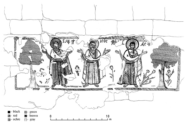
The Warehouse Complex. The warehouse complex (c. 75 by 40 m) in area KK, built c. 500 CE, consists of six warehouses of three distinct types: courtyard warehouses (I, IV, and V), a corridor warehouse (II), and a complex warehouse (III). Warehouse VI was probably also of the courtyard warehouse type. In a layer of fill in warehouse V a marble head of emperor Hadrian was found. The western side of the complex was bounded by a wall decorated with engaged pillars. Later another building was added to it, consisting of rooms arranged around a courtyard and with entrances into warehouses II and III. It was probably related to the operation of the complex. A corridor with three consecutive doors, running westward from the cardo, separated the warehouse complex from the mansion to its south, located in an area excavated by the IAA (which identified it as a bathhouse, although the bathhouse was only one component of this urban villa; see above for a discussion on the IAA’s excavation of the bathhouse). The villa and the warehouses extend together over an entire city block. The owner of the villa probably owned the warehouses as well. Inside the warehouses, spaces for the storage of different commodities can be identified:
- Storerooms for local jars, probably filled mainly with wine.
- Halls for storing large clay jars containing oil. The floors of these halls are covered with rough white mosaics. Such halls and rooms were found in warehouses I, II, III, and VI. In each, one pithos (or two, for example, in warehouse I) was sunk into the floor for the purpose of receiving any liquids that escaped a cracked standing jar. These pithoi came in two sizes, one with an internal rim diameter of 24 cm (under the floor of such a hall in warehouse II) and the other with a diameter of 43 cm (in warehouses I, III, and VI).
- Square-shaped underground granaries whose walls were faced with dressed stones laid in an oily mortar. This oily mortar (amurca in Latin) contained marble powder and did not harden when exposed. It was mixed with the oily water produced during the manufacture of olive oil. In the Roman world it had the reputation of being an insect repellent and was recommended for use in silos. The silo floors were covered with a rough white mosaic. In the center of the floor was a depression into which remaining grains could be gathered. One of the granaries (in warehouse III) had a floor of stone slabs. The underground silos come in groups of two (in warehouse I), three (in warehouse III), four (in warehouse V), and even six (in area NN east of the cardo). In two of the granaries of warehouse III the stone slabs lining the walls were preserved to their entire height. Their ceilings consisted of thick wooden rafters whose ends fitted into specially made depressions. This ceiling supported the mosaic floors of the rooms above, in which there was a square stone-lined feeding hole. Among the interesting finds in the granaries are an engraved gemstone bearing a depiction of a broken-backed reaper on one side and a Greek inscription asking for health on the other; two bread ovens, one in warehouse I and the other in warehouse V; and basalt millstone fragments. It would thus appear that baked bread, and not just grain, was sold here.
- Warehouse I, II, III, and IV each had its own well. The well of warehouse I was discovered on the northern side of the courtyard; of warehouse IV at the northern end of a narrow yard; of warehouse II inside the pithos hall east of the corridor; and of warehouse III west of the entrance hall with a rough white mosaic floor.
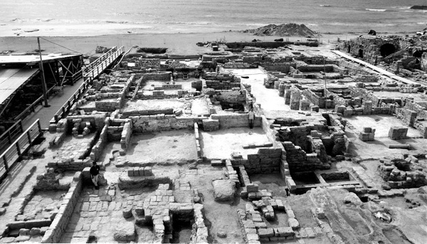
Warehouse I, structurally the most impressive of the courtyard warehouses, had an antechamber with a broad doorway opening onto the decumanus, decorated with two engaged pillars. To the right of the antechamber was a room with a mosaic floor and an underground pithos, which was probably used for retail sales. Beyond this room was a courtyard with a stone-slab floor surrounded by pillars supporting arches. South of the courtyard were two underground silos. North of the silos was a room with a multicolored mosaic floor, a plastered stone bench, and another bench later built on top of the mosaic floor. The eastern side of the room served as a separate exedra. The shape and installations of the room make it probable that this was the office of warehouse I. South of the courtyard a pithos hall (30 by 5 m) was found whose plastered walls are preserved up to a height of 2.5 m. Protruding piers in the central section of the hall indicate that the ceiling of this part of the hall was supported by arches; a number of voussoirs were indeed found during the excavation. The large amount of debris taken out of this part of the hall during the excavation suggests the existence of a second story. On many of the fallen stones the plaster was still intact, including remnants of paintings depicting colored crosses decorated with inlaid stones and one-line Greek inscriptions in red lettering. Among the small finds in this area was a clay eulogia bread stamp, of the type that was handed out or sold to congregants and pilgrims after mass. This round stamp was decorated with a cross inside an arched aedicule, and around its periphery was a Greek blessing in the names of Christ and St. Paul. The bread it stamped could have been baked in the oven of warehouse I. These remains are possible evidence for the existence of a chapel dedicated to St. Paul on the second floor, above the central section of the hall. North of this chapel, on a lower level reached by a ladder, there was probably a crypt-like burial chamber, as demonstrated by two stone sarcophagi and epitaphs found nearby.
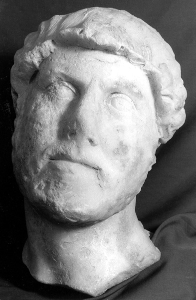
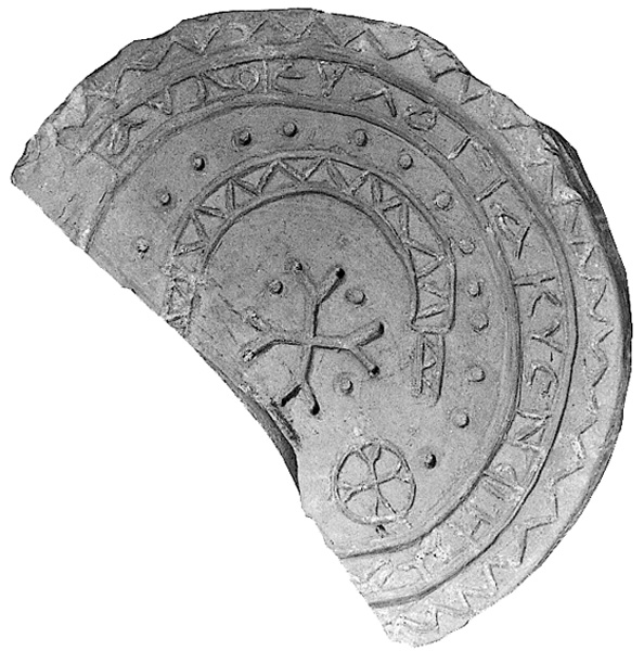
Warehouse II is a simple corridor storeroom, with a mosaic-paved pithos hall on the east and small storage chambers for jars on the west. The four silos of warehouse V penetrate into warehouse I. Both warehouses V and VI have rooms opening onto the cardo, which probably served as shops. In one of the rooms, located on the intersection, two benches have been preserved, and a bone die was found. Two shops open onto the decumanus were later sealed off. The storage rooms of warehouse III are arranged around a central pithos hall. In the front of the warehouse, on the western side, is an entrance hall oriented north–south and entered from the courtyard of the building to the west. On the southern side of warehouse III is an elongated storage hall of unusual dimensions; its walls have been preserved to a height of 3 m and more.
Irrigated Gardens. The end of the urban era in the excavated areas is reflected in the neglect and abandonment of buildings. Stratum IVA is marked by a layer of fill some dozens of centimeters thick, which accumulated inside the abandoned Byzantine structures. The first period of decline probably occurred during the Persian conquest (614–627 CE). According to the Acts of Anastasius the Persian, which were written at that time, the Persian governor installed himself in the Byzantine governor’s palace. During this final period of occupation the buildings appear to have been poorly maintained. They were probably abandoned during the Muslim siege (634–641 CE), after which building stones were robbed, mainly along both sides of the cardo.
Above stratum IVA is a thick, distinctive layer (stratum IIIB) containing the rubble from the collapsed walls of the Byzantine structures. It is clear that entire walls were intentionally demolished to make way for an irrigated garden. The preparations included bringing soil, rich in organic waste, which was spread over the debris (and made up stratum IIIA), the construction of agricultural terraces, the raising of the walls of existing wells up to the level of the gardens, the digging of new wells, and the construction of stone vats and irrigation channels that brought water from the wells to the terraced plots. Traces of these irrigated gardens were found all over the excavated area, except where damaged by later tombs. The small finds collected from the garden soil (coins, lead bullae, stone, metal and glass artifacts, lamps, and pottery), as well as the finds inside the wells, indicate that the gardens were a project carried out by the Byzantine populace. A cross was incised into a column of the latrine next to the intersection when the column was already lying on its side and being used as part of a terrace, proof that the terraces were constructed by Christians. It seems that the gardens date from the lengthy Muslim siege, when the city’s inhabitants could not go out and cultivate their fields or bring in agricultural produce. Such a great change in the city’s landscape could only occur after the aristocratic citizens, including the chief landowners, had abandoned the town.
The gardens thus provide archeological proof of a very dramatic period in the city’s history, evidence of extraordinary circumstances which brought about the ruralization of a heretofore urban area, a process which can be discerned in many cities toward the end of the Roman–Byzantine period. The gardens ceased being cultivated in the Early Islamic period: in the entire excavated area not a single potsherd was found in this stratum which can be dated to later than 700 CE, and the finds are all Byzantine. The wells too were forgotten, and were not integrated into the next stratum, the cemetery.
A Cemetery. After the gardens were abandoned, the area was covered by a thick layer of sea sand containing worn Byzantine potsherds, apparently stemming from harbor dredging operations conducted in the Abbasid period. Later in the Abbasid period, graves began to be installed in that layer and the one above it. The cemetery remained in use until the Ottoman period. The positions of the skeletons and the structure of the graves make it possible to differentiate between early Muslim graves (from the Abbasid and Fatimid periods) on the bottom, Christian graves from the Crusader period above them, and the later Muslim graves (from the Ottoman period) on top. Most of the graves have an east–west orientation, with the head to the west. The Muslim skeletons were laid on their sides, facing south, whereas the Christians were buried on their backs, facing upward, with hands either folded in various ways on the chest or extended to the sides. Most of the graves were simply dug in the earth with no construction, and a thick layer of seashells was poured into them. Some graves were lined and covered with stone slabs. Very few of the Muslim graves demonstrate monumental features. One exception to this is a family grave (in square KK16) in which a stone fence surrounds a double grave marked by two rows of stones triangular in section. Area NN yielded another “monumental” grave, perhaps a weli, with an unusually rich collection of tableware from the time of Ibn Tulun. In another burial compound in area CC, two epitaphs in Arabic were found, one dating from 870 and the other from 895 CE. Nails found around the Christian skeletons demonstrate that they were buried in wooden coffins, which have completely disintegrated. A few burial offerings were also found, including a number of crosses.
JOSEPH PATRICH
UNDERWATER EXCAVATIONS. The CAHEP (Caesarea Ancient Harbour Excavation Project) consortium, led by the Recanati Institute for Maritime Studies at the University of Haifa, in collaboration with the University of Colorado (led by R. L. Hohlfelder), the University of Maryland (led by R. L. Vann), and the University of Victoria, British Columbia (led by J. P. Oleson), was succeeded by the maritime unit of the CCE, a collaborative project of the University of Haifa (led by A. Raban) and McMaster University (led by E. G. Reinhardt). The ongoing project conducts an annual field season with student volunteers from both institutions as well as others from around the world. The focus of the underwater research has shifted lately toward geoarchaeology, in an attempt to comprehend the history of maritime activity at Caesarea and the demise of Sebastos in the context of environmental changes and topographical alternations on the waterfront.
The Pre-Sebastos Phases. Chance findings on the sea-floor within the harbor basin, under its western mole, or beyond it to the west, included cigar-shaped and basket-handled Phoenician amphorae of the fourth–fifth centuries BCE. Yet the datable sherds in the stratigraphic contexts of the two closed harbors of Straton’s Tower, including a few dozen Rhodian stamped amphora handles, all date to the second and early first centuries BCE. Terrestrial excavations along the western façade of the temple platform and further to the north and northwest indicate that the southern harbor was nearly twice the size formerly suggested, its southern limit located beyond the medieval city wall, its eastern limit c. 12 m beyond the eastern quay of Sebastos’ inner basin, and its northern extent c. 80 m further than had been surmised. Its protected water basin, of roughly oval shape, was c. 5 a., with an average depth of c. 2.4 m. It was protected on the western side by a sea wall that began at its northwestern corner, running south for c. 120 m and terminating at a 13-m-diameter round tower, similar in size and construction to the twin towers exposed by the Italian expedition to the north. The threshold of a small port at the seawall, just next to the tower and its circular slab-paved floor, now lies under 1.3 m of water. The entrance to this port was from the northwest, through a 60-m-wide channel, between the round tower and the lee side of the rocky outcrop of the so-called harbor citadel, originally an inshore islet.
Outside that harbor basin, to the northwest, at the western edge of a low rocky coastline (area LL), was a quay constructed of ashlar headers, 38 m long, that terminated on the north in a protruding jetty running west for 16 m. The jetty was 7.8 m wide and comprised 2-m-long ashlar headers. Though not datable by finds, this marine complex seems to be pre-Herodian, on the basis of both stratigraphic and stylistic considerations.
The Herodian Harbor of Sebastos. Recent research has concentrated mostly upon the northern part of the main western mole. An interesting component that was studied here is a complex of at least five rectangular wooden caissons, 14 by 7 m each and originally over 4 m high. All were constructed in the finest tradition of “shell-first” shipwright technology, with framed floor and central inner chamber. The floor and side walls, constructed of 9-cm-thick planks of European soft wood, were fitted together with mortises, tenons, and treenails. These caissons, or single-mission barges, were prefabricated on the nearby shore. Upon completion, an admixture of volcanic tuff, lime aggregates, and clay was then poured over their floor and left to dry and harden as pozzolana concrete. The barges were then launched and towed to the designated building site in the open sea. There the caissons would have been moored tightly with iron chains at their four corners to the sandy sea-floor, previously “paved” with a substantiating cushion of cobbles so as to prevent eventual undertrenching by agile currents. Once securely moored, each caisson was filled with an additional burden of lime concrete mixed with quantities of rubble aggregates. The intent was to sink the partly filled caisson evenly, so that it would settle properly on the sea-floor. It was then filled to the rim, just above the waves, with additional pozzolana concrete. Repetition of this process created an artificial island at the northern tip of the main western mole, c. 40 by 20 m—too narrow to accommodate a large lighthouse or other massive tower such as the Drusion, to which Josephus referred. The bases of the caissons examined were found to be tilted slightly toward the north–northeast and now lie under c. 9 m of water.
A similar type of artificial island, larger in size at c. 48 by 27 m, its base presently lying at a depth well over 10 m, has been surveyed and partly excavated at approximately the mid-point of the external side of the main mole, where it turns northward (area U). This complex is less coherent and hardly a single caisson has been found intact. It seems that this part of the harbor suffered exceedingly from repetitive tectonic upheavals through the ages. The 14C analysis of the caisson timbers gave calibrated dates of 2050–2120
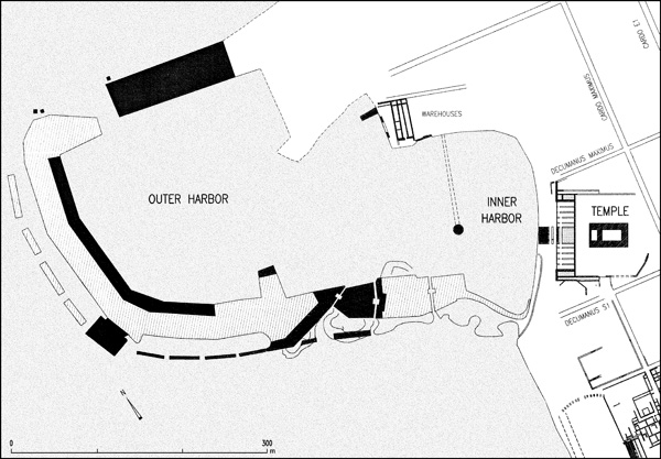
Segments of the harbor’s ashlar-paved promenade have survived in situ, at an elevation of c. 6 m below mean sea level, at many places over the presently subsided western mole. When removed, these pavers were found to have been laid over a rather thin layer of small rubble that overlies 3–4 m of well-sorted sediments, laminated according to grain size. These undisturbed accumulations must have been deposited within a confined space, well protected from the force of the waves. This indicates that the main moles were built only as confining walls, leaving most of their inner volume to be gradually filled in by the elements—added depositions of wave-carried sediments. Once these compartments were silted up to sea level, the area was capped by rubble and paved with ashlar slabs. This method enabled the harbor’s master builders to save over 70 percent of the volume of building material required for the lower part of these moles. The inner line of the moles was built as a vertical stone wall, comprised of ashlar headers over 2 m in length. The external, or rather, the spinal wall, was constructed in the Italian technique of pilai—a sequence of free-standing, wooden-formed, cast pilasters of pozzolana concrete, each c. 8 by 8 m and of heights matching the depth of the water at their given location. These pilai were installed over a cobble-cushioned sea floor at even intervals of c. 10 m. This was then covered by a rampart of packed rubble. They may have served as a substantiating base for the “evenly spaced towers along the spinal seawall” described by Josephus.
The segmented subsidiary breakwater that Josephus called the procumatia was added at a later phase, some 25–30 m outside the southern and western sides of the main mole, enhancing breakage of the wave’s energy well off the main mole, protecting it from scouring currents and from spillage of sea water over its seawall.
The twin towers, or “upright stones” referred to by Josephus, installed on the sea-floor just outside the entrance channel to the harbor, “on the right hand side of those sailing in,” were located and exposed. They were also composed of huge cast pilai. The southeastern one is now lying on its side; a large stone slab next to it still supports the truncated bases for the feet of a colossal statue that, according to Josephus, stood on two upright blocks of stone joined together. The tower on the other side of the entrance channel has also been exposed and was also a wooden-framed pila, c. 12 by 12 m in size.
Other interesting components of the port of Sebastos designed to continue functioning properly over time are the flushing channels along its southern and southeastern sides. These were rock-cut and stone-built channels that dissected the broad mole along a diagonal southwest–northeast course. Their well-sluiced inlets just above sea level at high tide would have absorbed incoming waves and allowed excess water from the open sea to flow into the harbor through a settling basin. The excess volume of silt-free sea water would flow back out to open sea via the harbor channel, thereby enhancing an outflowing current that may have prevented the entry of wave-carried sand and would have flushed suspended silt from the harbor basins. At least three of these channels have been identified and studied along the southern side of the intermediate and inner harbor basins of Sebastos.
Two main elements of the intermediate harbor basin were studied in the 1990s. The southern quay, just west of the harbor citadel, was exposed all the way down to its rocky base, at almost 6 m below mean sea level. It was formed of pozzolana concrete in a deep topographic gap between two rocky outcrops. On land, next to the northeastern side of this basin, a complex of Byzantine horrea, first excavated by L. Levine and E. Netzer on behalf of the Hebrew University, was found to originally have been three parallel ship-sheds of the Herodian period. In addition, a c. 43-by-40-m rock-cut hollow next to the complex on the east had a gently sloping base toward the water line in the south. This may have been part of another, wooden-roofed, ship-shed unit. These units, just over 40 m long and nearly 6 m wide, would have been adequate storage facilities for warships, probably those of Herod’s alleged fleet.
The outline of the inner harbor basin has been revealed with the exposure of its curved southeastern side, just outside the medieval southern city wall (area I12), and its northeastern side, some 200 m to the north (area I11). Over 120 m of the southeastern part of the enclosing quay was exposed in presently land-locked locations, as well as portions of its northwestern and northeastern parts. The vertical seaward face of the quay was comprised of wooden-cast pozzolana concrete resting on a leveled ledge of bedrock. It rises to a level just above the elevation of ancient sea level and three courses of ashlar headers were laid upon it to a height of just over 1.6 m above mean sea level. Double flushing channels were installed on top of this quay, c. 5 m beyond its edge, carrying wave-induced sea water from the southern bay. The overall area of the basin seems to have been slightly less than that of the southern harbor of Straton’s Tower, as the Herodian quay was installed in deeper water so as to allow larger vessels, of a draft up to 2 m, to moor against it.
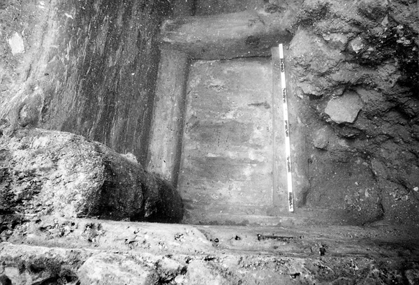
The Roman Period Harbor. Geoarchaeological studies indicate that Sebastos lost the integrity of its main moles by the last quarter of the first century CE, probably as a result of tectonic upheavals and lack of proper maintenance. The offsetting and down-tiltage of the caissoned components at the tips of both moles enhanced an extreme rate of undertrenching, which can be roughly dated by the redeposited sherds in the scoured trenches beneath these caissoned units. A more precise date is provided by metal remains at the wreckage site of an ill-fated merchantman that foundered over the southern caisson at the tip of the western mole (K8). Among these items were coiled pieces of the lead sheathing, a score of copper nails and bolts, and half a dozen stamped lead ingots, marked on their crest IMP. DOMIT. CAESARIS. AVG. GER, and on their side MET. DARD. (for metalla dardanica, the name of a foundry in the Roman province where the present-day Balkan town of Kosovo is located).
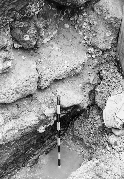
Other indirect data confirm this interpretation, such as wave-deposited sand accumulations over the ashlar quay on the northern side of the intermediate harbor basin, found to be topped by a terrestrial floor of the second century CE, and similar deposits next to the foot of the eastern quay of the inner basin. The process of dilapidation seems to have continued through the entire Roman period and into the Byzantine period, as attested by the various shipwreck sites over the subsided sections of the main moles, remains within the harbor basin, and the excessive pace of silting within the inner basin.

A series of probes and stratigraphic cores conducted in the external and the intermediate harbor basins attest to at least two parallel tectonic fault lines, which dissect the harbor area from north-northeast to south-southwest, causing repeated offsetting of the sea-floor amounting to 4–6 m up to the present day, and even more for the heavy structures of the moles that sunk into the non-consolidated sea-floor.
During the 2003 field season of the CCE, a formerly unnoticed architectural feature was excavated underwater at the northeastern side of the intermediate harbor, in the area designated LW. This was a presently submerged quay, running more or less east–west along a somewhat curved line, from about 50 m southwest of the Herodian quay in area L and over 30 m west of the western end of the northern seawall of the inner basin. The quay is comprised of a vertical wall of four uneven courses of reused ashlars of various sizes and some reused column drums, some of which are still coated with lime plaster on their inward-facing sides. The top of this wall is presently 0.6 m below mean sea level and its base is under 1.9 m of water, with a thin layer of fine mud between it and the kurkar bedrock. The deposited mud reaches about half the height of the bottom course, and may be dated to the period up to the late first century CE, based on the badly eroded potsherds that have been retrieved from it. Above the mud, the face of the wall, which has been exposed for a stretch of over 20 m, is coated by types of marine fauna that would develop in oxygen-rich sea water of limited wave energy. This wall is the southern edge of a rather extensive paved platform of rectangular stone slabs averaging 1.2 by 0.7 m, the surface of which is under 0.6 m of water. The quay went out of use when the seabed next to it was silted up by deposition of coarse sand, seashells, and quantities of potsherds—mostly of trade amphoras from all over the Mediterranean and the Black Sea, dated to the fourth century CE. The quay’s elevation and orientation does not correspond with any of the shoreline architectural elements in area S, and its location leaves the earlier quay in area L well landlocked. However, the medieval “columns quay” to the north of it was based on a sandy beach that passed over and buried this recently discovered Late Roman quay that seems to have functioned for no more than a century. Its present subsidence demands an explanation, given its position over bedrock in an area considered to lie on the stable side of the alleged tectonically active fault line.
Other intriguing data were uncovered during the 2003 season a few hundred meters outside the submerged harbor of Sebastos, on the sea-floor in open sea, at a depth of over 12 m and over 1 km offshore. There, a series of probes was conducted to investigate the significance of magnetic anomalies that were traced during a remote-sensing magnetic survey carried out in 2001 using a Cesium proton magnetometer. Seven magnetic “hotspots” were probed and each was found to contain quantities of jettisoned ballast stones, mostly of volcanic and igneous rocks, and scores of potsherds of late Byzantine date—an indication that during that period the merchantmen would ride on anchor offshore rather than risk attempts to sail in over the hidden remains of the tumbled moles of Sebastos. In two of these probes, at a depth of about 1 m below these remains, the excavation exposed a compacted layer nearly 0.5 m thick comprised of seashells, pebbles, and eroded potsherds of the first century CE, with some Hellenistic pottery in the loose sand below (including a stamped Rhodian amphora handle). This compacted deposition of coarse materials at a depth of over 13 m and at such a distance from shore might indicate an event involving exceptional wave energy, on the level of a retreating tsunami. The suggested date of that event, sometime between the late first and early second centuries CE, coincides with evidence for the initial demise of Sebastos. It is therefore possible that an unrecorded tsunami was one of the destructive agents.
The Byzantine Period Harbor. Remains of what may have been a serious attempt to renovate Sebastos have been traced along the inner side of the northern mole. These consist of an additional mole comprised of a massive spill of rubble that runs westward as far as the northern tip of the western mole and over the entrance channel. Datable sherds buried under this spill enable us to date the attempted renovation to c. 500 CE. Such a date corroborates the textual eulogy of Procopius Gazeus praising Anastasius I for reconstructing the Augustan harbor of Caesarea. Yet, geoarchaeological data from the underwater probes within the intermediate harbor basin indicate that by the mid-sixth century CE additional tectonic upheavals caused accretion of the deposited sediments and perhaps affected the high-level aqueducts along the seafront to the north.
The Harbor in Later Periods. The large amounts of later Byzantine pottery, building debris, and other material remains dumped into the intermediate basin would appear to indicate that the harbor was deliberately filled in sometime after the Muslim occupation, probably following the Byzantine sea raid against Caesarea in 675 CE. Probes in the western part of that basin indicated that this fill was dredged at some later date and dumped in two huge piles on the shore to the south. These dumps have been found to include the very same components as the underwater fill, including quantities of marine-encrusted late Byzantine sherds. The fact that these piles were used as burial grounds from the late Abbasid period indicates that there had been an earlier attempt to renovate harbor facilities, probably in order to enhance seaborne trade with Egypt. Yet very few artifacts datable to the Abbasid and the following Fatimid period have been retrieved from the sea-floor in this area. Among these are some gold coins, including an Aghlabid specimen from North Africa and a dozen stone anchors of typical medieval types.
The recent excavations have exposed additional segments of the presently submerged Crusader period seawall (area T2), confirming that it was founded upon a base-course comprised of Byzantine and Roman column shafts in secondary use, laid parallel to each other on the seabed, to strengthen the western side of the structure. Along the lee side of that seawall was a 6-m-wide quay, built of small ashlar blocks. It extended southward from the northeastern side of the ancient harbor for c. 120 m, terminating at a large rectangular tower.
The jetty built of columns beyond the seawall to the northwest was found to have extended from a crescent-shaped sand beach. Only sloping beach rocks have survived the maritime erosion there.
Conclusion. Sebastos, the royal harbor of Herod the Great, was by far the most sophisticated feat of marine engineering in antiquity, a collaborative endeavor incorporating “local” Phoenician harbor building traditions and the Hellenistic concept of limen kleistos. Italian innovations, such as pilai of pozzolana concrete cast in wooden molds, were utilized, and a unique and unprecedented manipulation of the natural coastal processes was carried out. However, this technical wonder endured for only a short time. Due to an unstable site and a scale too large for later local demand and seaborne trade, its demise was unavoidable and probably did not seriously affect the economic prosperity of Caesarea, which continued to engage in seaborne trade, despite the lack of a decent year-round harbor.
AVNER RABAN
The Coins
The Inscriptions
The Promontory Palace
The Synagogue
The Water Supply
Maritime Caesarea
THE ISRAEL ANTIQUITIES AUTHORITY EXCAVATIONS
EXCAVATIONS
Large-scale archaeological excavations were carried out at Caesarea from 1992 to 1998 by the Israel Antiquities Authority (IAA); they were directed by Y. Porath. The project included the excavation of a 100–150-m-wide strip along the coast between the theater complex to the south and the excavations of the Combined Caesarea Expeditions (CCE) to the north; the western part of the temple platform and the area between this platform and the eastern quay of the port of Sebastos; both sides of the southern Crusader wall (continuing the salvage excavations carried out in 1989); the bottom of the Crusader moat (cleared in the 1960s by A. Negev), from the southern gateway to the northern gateway; and the area southwest of the theater. In addition, salvage excavations were conducted within the area demarcated by the Byzantine wall; in structures outside the wall; on the necropolis; in agricultural areas to the east, north, and south of the city; and along the aqueducts that carried water to Caesarea from outside the city.
