
Dawwara, Khirbet ed- (South)
THE SITE
Khirbet ed-Dawwara (South) is located on the crest of the Hebron Hills, about 2 km east of
EXCAVATIONS
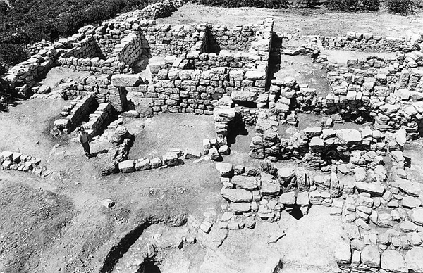
In 1995–1996 two seasons of excavations were conducted at the site by the Staff Officer for Archaeology in Judea and Samaria, under the direction of I. Sharukh. The excavations were concentrated in the main building at the summit of the site and in adjoining structures. The remains of four main periods were distinguished.
EXCAVATION RESULTS
THE EARLY ROMAN PERIOD UP TO THE SECOND JEWISH REVOLT. Remains of the Early Roman period up to the Second Jewish Revolt evident in all the excavated areas include ashlar masonry (appearing in secondary use in buildings of the Byzantine period) as well as pottery, stone vessels, glassware, and coins. The numismatic finds consist of a large number of Second Temple period coins, including a prutah from the second year of the First Jewish Revolt. Buildings of the Early Roman period are concentrated in the eastern part of the site, where no later structures were constructed. These remains include several walls, an extensive water supply system, mikvehs, and a refuge cave. The walls were put into disuse with the construction of a farm in the Late Roman period. The water supply system is situated in the center of the building complex and includes cisterns and drainage channels for runoff water. Three bell-shaped cisterns (cisterns 1–3) have continued in use to the present time, as has an elliptical reservoir (cistern 4; 9 by 2 by 3 m) with two entrances, one in the south and one in the north.

Two mikvehs were also uncovered. One is situated adjacent to the refuge cave, northeast of the building complex. It has a rectangular entrance room (2.5 by 2 m), with a rock-cut staircase of five steps covered with hydraulic plaster. The steps descend to the immersion pool, next to which is a rock-cut channel for runoff water. The rectangular immersion room was constructed in a natural cave that was widened and plastered to its full height (3.6 by 2.8 m, 2.25 m high). The second mikveh is situated south of the first, near the building complex. It consists of a rock-cut, rectangular entrance corridor with five steps, and the immersion room (2.6 by 2.5 m), which is a natural cave widened into a rectangular shape, curved on the west side, and straight on the other sides. Two channels conveyed runoff water to the mikveh, one from the west and the other from the northeast, near the steps.
The refuge cave, which was hewn taking into account the plan of the first mikveh, was uncovered in the easternmost part of the complex. Only its northern part was explored. It consists of several entrance rooms connected by a series of tunnels cut into the nari limestone. The hideout apparently started in the south and most of it lay under the Late Roman fortified building which was constructed after the complex had gone out of use. The section exposed contains an oval-shaped main chamber, roughly 14 by 10 m. From here several rock-cut tunnels lead to a number of smaller rooms and to an ancient cistern whose entrance was blocked when the site was prepared as a refuge. Some of the tunnel entrances were fitted with a frame for the placement of a stone closure, and vertical escape shafts, typical of the hideouts leading to the crest of the hill.
THE LATE ROMAN–EARLY BYZANTINE PERIOD. In the Late Roman–early Byzantine period, a fortified farmstead (50 by 30 m) was constructed on the site above the buildings of the previous period. The farmstead consists of a fortified building in the southern wing, a number of rooms in the northern wing, a central open courtyard paved with stone slabs, and an earlier network of cisterns that remained in use during this period in the eastern wing. The wall enclosing the farm was uncovered on three sides; some sections were preserved to a height of nine courses. It has two faces, the outer built of large, trimmed fieldstones and the inner of medium-sized fieldstones with small stones between the courses. Although the eastern side of the wall was not excavated, it probably contained the entrance to the complex, since the ancient road to the site from
The fortified building (16.5 by 12 m) in the southern corner of the complex makes use of part of the enclosure wall. Its walls were widened (up to 1.3 m) and have survived to a height of about 3 m; its entrance is in the middle of the eastern wall and was spanned by a lintel decorated with a rhomboid. Inside the building are two rooms paved with irregular-shaped stone slabs, one in the southern corner and one in the western, and an unroofed area in the middle. It can be assumed that this building served as the farm residence and as a watchtower, guarding the farmhouse and the surrounding agricultural land.
The northern wing of the complex contains a number of rooms, the largest of which (about 10.5 by 5 m) perhaps housed livestock, as is suggested by pieces of a trough found reused in a later structure. An elongated room to the west was probably a storeroom. Like the main courtyard of the complex, these rooms were also paved with irregularly shaped stone slabs, which in some places met portions of bedrock, leveled to serve as parts of the floor. The floors are dated to the third–fourth centuries CE and are associated with the rooms’ walls.
THE LATE BYZANTINE PERIOD. In the late Byzantine period, dated to the fifth–seventh centuries CE, the farmhouse was converted into a monastery displaying characteristic features of desert monasteries. It made use of buildings of the previous period but added a second story in places and other structures. The existence of a second story is attested to, among other things, by the discovery of four staircases on site. In the western wing of the fortified building, several new rooms and a second story were added; in its western corner another entrance was opened. The northern wing was turned into the refectory, with three vaults in the central hall supporting a second story, which apparently held a dining room. A bread oven was found near this building and in the center of the paved area; grinding and crushing utensils belonging to the kitchen complex were found in the adjoining rooms. A cooking stove was uncovered on the ground floor in the main room. Alongside it lay a large heap of fallen eating utensils.
A number of marble liturgical objects recovered in the excavations indicate that the monastery also had a chapel, the location of which could not be established, given the dispersal of such finds throughout the complex and the collapse of the second floor. Among the finds is a limestone chalice decorated with Christian iconographic motifs, including fish and a temple or sanctuary next to birds in a heraldic position. On the eastern side, vaults supporting a second story were built above the early water system; they yielded a large number of storage vessels. The size of the central area was reduced with the construction of additional rooms in this stage.
THE EARLY ISLAMIC PERIOD. This period continued until the eighth century CE, when the site may have been destroyed in an earthquake. At this time a number of minor changes were made in the complex: the arches were closed and several walls were added, most of them utilizing materials from earlier buildings. The fortified building was turned into an olive-oil press, from which a stone basin and a fragment of a post were uncovered.
SUMMARY
Sparse remains dating from the Hellenistic to the Early Islamic periods were uncovered at the site. A study of the finds indicates that the site underwent a number of changes, beginning as a Jewish settlement in the Second Temple period, the remains of which include mikvehs, stone objects, and coins. The inhabitants of the site played an active role in the Second Jewish Revolt, as is indicated by the refuge cave. About 150–200 years later, the site was converted into a farm, probably by non-Jews. From the fifth century CE, a Byzantine monastery occupied the site, perhaps destroyed by an earthquake at the end of the eighth century CE.
SHAHAR BATZ, IBRAHIM SHARUKH
THE SITE
Khirbet ed-Dawwara (South) is located on the crest of the Hebron Hills, about 2 km east of
EXCAVATIONS
In 1995–1996 two seasons of excavations were conducted at the site by the Staff Officer for Archaeology in Judea and Samaria, under the direction of I. Sharukh. The excavations were concentrated in the main building at the summit of the site and in adjoining structures. The remains of four main periods were distinguished.