
‘En Ẓippori, Tel
INTRODUCTION
Tel ‘En
Tel ‘En
EXCAVATION RESULTS
Eight occupational strata have been identified, with occupation beginning in the Early Bronze Age IV and continuing from the Middle Bronze Age II/III through the Iron Age I (late eleventh century BCE). A gap in the stratigraphic sequence is followed by a brief reoccupation in the Iron Age II (ninth century BCE).
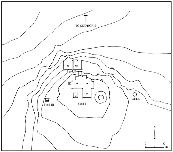
THE EARLY BRONZE AGE IV (STRATUM VIII) AND MIDDLE BRONZE AGE II/III (STRATUM VII). Although some Early Bronze Age IB sherds were found, the earliest stratified material dates to the Early Bronze Age IV. Sherds of that period (stratum VIII) were found in a deep probe in field II that reached 1.5 m below the current level of the valley floor. Stratum VII dates to the Middle Bronze Age II/III and includes a poorly preserved jar burial, scanty architectural remains, and pottery.
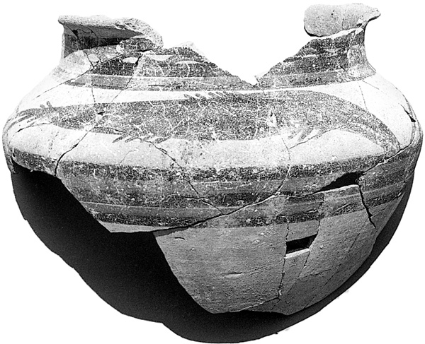
THE LATE BRONZE AGE I (STRATUM VI). Stratum VI is well represented in field II by a rectangular stone structure with at least six internal rooms and a sequence of four living surfaces. It features a long north–south wall constructed on a foundation footing of cyclopean stones. A storage jar and several well-made basalt pestles were found in a niche built into the eastern face of its southern end. Several restorable vessels were discovered in its middle room, along with an impressive array of imported pottery including Late Bronze Age I bichrome ware, chocolate-on-white ware, Cypriot white slip I, and Cypriot gray-burnished bottles. A beautiful bichrome krater, uncovered on the final Late Bronze Age I surface, is decorated with two large fish that appear to be barracudas, which are native to both the Mediterranean and Red Seas. Stratum VI ended in destruction.
THE LATE BRONZE AGE II (STRATUM V). An enigmatic installation found to the east of the Late Bronze Age I building in field II is the only architectural element built in stratum VI that was reused in stratum V. A semicircular stone wall built around a large, flat stone slab, it is demarcated to the north and west by stone walls (aligned to the cardinal directions). There is also a short stepped platform to the north. A large Late Bronze Age I krater was buried to the east within a semicircular line of large cobbles. The krater was empty except for fragmentary remains of an immature sheep/goat skull along with a few toe bones from an adult sheep/goat. A beautiful hematite weight (10 grams, a Ugaritic shekel) was found next to the krater. Surfaces of both the Late Bronze Age I and II are associated with the eastern and western sides of this installation. The stone slab base was modified and used in conjunction with an aperture, which may have originally served as a drainage conduit, in the back of the semicircular wall. Two complete basalt bowls, with associated Late Bronze Age II pottery, were found on a surface that covers the sunken krater. A complete Late Bronze Age II lamp was also retrieved on a beaten-earth surface that covered the stone slab in stratum V. The function of this installation is not certain; it may have been used for rituals, for food-processing purposes, or both.

To the west of this installation another stratum V building was constructed over the remains of the Late Bronze Age I structure. It is a very large building, some 15 m in length, and was built along a different orientation than the stratum VI structure. A range of Late Bronze Age Cypriot pottery, as well as a few Mycenean IIIB imports, was found in this building. Late Bronze Age II sherds but no buildings were also recovered in field I.

One of two lead votive figurines recovered from the site was found in stratum V in a mixed debris layer. This figurine does not have any direct parallels, but it is similar to Negbi’s “Byblos” group.
THE IRON AGE I (STRATA IV–III). The large stratum V building in field II continued in use into the Iron Age I (early twelfth century BCE) with some modifications, such as a new doorway and an addition extending to the east. A new courtyard added to the building’s south contained several installations consisting of the inverted tops of collar-rim storage jars, one of which was used as a tabun. Well-preserved remains of stratum IV were also found in field I, indicating an early Iron Age I occupation at the site, in continuity with the Late Bronze Age II settlement. Remains in field I include at least two long rooms and many broken storage jars, apparently smashed in the destruction that brought at end to stratum IV.
The site was thoroughly redesigned in stratum III (eleventh century BCE). Stratum III domestic structures—part of a four-room house and a small alley with adjoining rooms—were recovered in field II. Three parallel walls, delineating at least three terraces on the northern slope of the site, were found to the west of the four-room house. The southernmost terrace wall is over 11 m long and over 1 m wide. There are at least three distinct occupational phases in stratum III of field II.
The largest structure at the site, probably a public building, is a large multi-roomed structure located in field I. Called building A, it measures 18 by 13.5 m and was constructed in part on a deep earthen foundation, which raised the level of field I buildings almost 2 m above those of field II. It was a prominent feature at the site and along
One of the most significant architectural elements of the site is a stone silo, 4.5 m in diameter and preserved to a height of 2.54 m. Constructed of cobbles and fieldstones, it has a well-made cobbled floor and neatly abuts building A’s western wall, although it is founded some 1.5 m lower than the southwestern corner of the building. Its volume is approximately 40 cu m. A silo of this size associated with a multi-roomed building (building A) with a large courtyard indicates that the site and especially the building probably had an administrative/redistributive function. Thumb-impressed storage jar handles, the only significant small finds from the building, support the interpretation of the site as a local administrative center in this period.
Building A did not stand alone. The corners of two other rectangular buildings have been identified to its south and southeast. In what must have been an outdoor courtyard, also to the south, was found another lead figurine, a small female votive with a Hathor headdress, similar to Negbi’s “Byblo-Palestinian” group. Both figurines can be dated typologically to the beginning of the Late Bronze Age. Because Tel ‘En
Other than a few restorable eleventh-century storage jars, little else was left in any of the interior rooms of building A (other than in the west wing), and it appears to have been deliberately emptied prior to its complete destruction. Thick deposits of burned mud-brick debris were found within the building, suggesting it was destroyed by fire sometime in the late eleventh or early tenth century BCE.
THE IRON AGE I–II TRANSITION (STRATUM II) AND IRON AGE II (STRATUM I). After the destruction of stratum III, the site seems to have been partially abandoned. This is particularly evident in field II. In field I, however, there is evidence of a brief phase of occupation built on the wall stubs of building A. This very ephemeral squatter phase, stratum II, can be dated to the end of the eleventh or beginning of the tenth century BCE. Parts of three structures, all constructed in a very flimsy fashion and poorly preserved, have been recovered. The pottery is identical to the stratum III material.
Stratum I dates to the ninth century BCE and is found only in field III, along the western slope of the tell, where part of a pillared building was discovered. Excavation on this slope also clearly demonstrated that the site was not fortified in the Iron Age II.
SUMMARY
The multi-period settlement of Tel ‘En
J.P. DESSEL, CAROL MEYERS, ERIC MEYERS
INTRODUCTION
Tel ‘En
Tel ‘En