‘En Gev
RENEWED EXCAVATIONS
Starting in 1990, renewed excavations were conducted at ‘En Gev by a Japanese expedition as part of the Land of Geshur Project. These excavations ended in 2005. During the first years of excavation, the Japanese expedition was headed by H. Kanaseki of Tenri University, later followed by A. Tsukimoto of Rikkyo University. G. Kovo acted as Israeli coordinator for the Land of Geshur Project until 2001. Y. Paz was the Israeli coordinator for the project from 2003 onward.
The renewed excavations have exposed a large area of over 1,000 sq m on the northeastern corner of the acropolis. So far five major strata have been defined: stratum I—the Roman and Byzantine periods; stratum II—the Hellenistic period; stratum III—the Persian period; strata IV–V—the Iron Age II.
EXCAVATION RESULTS
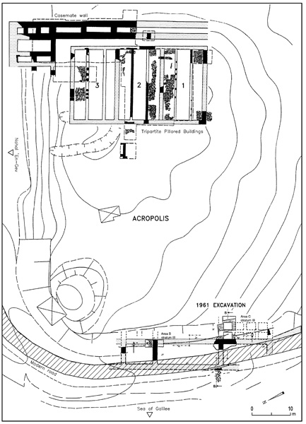
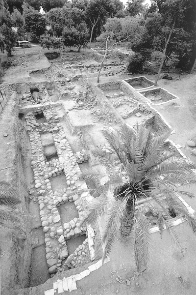
STRATUM V (formerly strata IV–III). A casemate wall built on virgin soil and three tripartite pillared public buildings were uncovered. The 35 m stretch of the casemate wall has been exposed at the northeastern corner of the tell. The average widths of its inner and outer walls are identical (unlike the casemate wall unearthed in the 1961 excavations at the southern end of the tell), at 1.5 m; the average total width of the wall is 4 m. Seven casemate rooms were excavated, with an average width of 1.8 m and lengths ranging from 6 m to just 2 m near the northeastern corner. Wherever the excavation reached their floors, they were found to be stone-paved. The reason for the wall’s unusual solidity resides in the fact that it was also a retaining wall for the fill that raised the acropolis c. 3 m above its foundations. Local conditions prevented exposing the corner of the wall in its entirety; however, it can be assumed to have been in the form of a “double casemate wall,” where the casemate rooms are arranged perpendicular and not parallel to the wall. The reason for this phenomenon (also observed in areas B and C of the 1961 season) was the instability of the water level on the lake’s coast and at the estuary of

The three pillared buildings were constructed atop a fill inside the corner of the acropolis formed by the wall. The wall and the buildings appear to be contemporary, though differences in their respective heights make it impossible to ascertain a definitive archeological connection between them. Modern military trenches as well as the construction of other pillared buildings on the same spot in stratum IV have prevented the exposure of the entire complex, although its plan can be reconstructed.
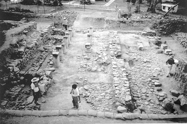
The complex extends over an area c. 36 by 20 m. Its three buildings are adjacent to each other, sharing walls. Each building is divided into three elongated halls separated by stone pillars standing on a stylobate. The floors of the exterior halls are paved; those of the interior halls are of packed earth. In the southern, exterior wall, a few bricks have remained in situ; it thus appears that all the walls were built of bricks resting upon a stone foundation. There are signs of paved streets running south and west of the complex. The western wall of the complex has yet to be excavated, and therefore the location of the entrances remains unknown. The scanty pottery is largely similar to that found within the casemate wall.
STRATUM IV (formerly stratum II). After the complex with the three pillared buildings went out of use, two new pillared buildings were erected on the ruins of the two southern buildings of the former complex. Extensive use was made of the older buildings’ paving and building stones. The new buildings were slightly narrower (10 m versus 12 m); a considerable part of their walls and square pillars have remained in situ up to a height of c. 1.2 m. Astonishingly, the top of one of the pillars reached the floor level of a house of stratum II and was then used as a mortar. The few potsherds found on the floors of the later pillared buildings can be dated to the eighth century BCE.
STRATUM III. Remnants of a Persian period (fifth-century BCE) settlement were found. These consist of pits containing Persian period pottery, dug into the Iron Age strata. Sherds from the same period were also found outside the pits, but no architectural remains with which these could be associated were uncovered.
STRATUM II (formerly stratum I). It was only in the Hellenistic period (second century BCE) that building activities recommenced on the tell. Densely built private houses were constructed directly over the remains of the Iron Age buildings, but oriented differently and extending beyond the limits of the Iron Age site. Centuries of neglect had eroded the layer of fill extant during the Iron Age between the casemate wall and the pillared buildings, and a gentle slope was formed. The houses of the Hellenistic settlement were constructed on terraces on this newly formed slope, extending past the line of the ancient wall. These were simple houses with courtyards containing cooking and baking installations. Most follow the same general plan and show signs of two building stages. A 2 m-thick stone wall protected the settlement on the north, where
STRATUM I. Two lime pits dug into the northeastern slopes of the abandoned tell are dated to the Roman–Byzantine period, when nearby Hippos-Sussita flourished.

SUMMARY
The settlement at ‘En Gev had its beginnings in the tenth or ninth century BCE. The planned, fortified city built at that time was probably part of a wave of Aramean settlement on the northeastern shores of the Sea of Galilee. Aramaic inscriptions have been found at Bethsaida, the capital of this new region; at Tel Hadar, which was rebuilt at that time; and at ‘En Gev, the border town between the kingdoms of Damascus and Israel. The pillared buildings, of a commercial function, were reconstructed and rebuilt, testifying to the fact that in the Iron Age II ‘En Gev replaced Tel Hadar as the commercial port on the eastern shore of the Sea of Galilee. This entire settlement complex was destroyed in 732 BCE when Tiglath-pileser III of Assyria conquered the Aramean kingdom of Damascus and the northern part of the kingdom of Israel and exiled their populations. The excavations at the site allow it to be identified with biblical Aphek, described in the wars of Jehoash and/or Ahab against the Aramean king Ben-Hadad. Attempts at resettlement during the Persian and Hellenistic period were relatively short-lived, with Hippos-Sussita and its port becoming the main settlement in the area.
MOSHE KOCHAVI, AKIO TSUKIMOTO

RENEWED EXCAVATIONS
Starting in 1990, renewed excavations were conducted at ‘En Gev by a Japanese expedition as part of the Land of Geshur Project. These excavations ended in 2005. During the first years of excavation, the Japanese expedition was headed by H. Kanaseki of Tenri University, later followed by A. Tsukimoto of Rikkyo University. G. Kovo acted as Israeli coordinator for the Land of Geshur Project until 2001. Y. Paz was the Israeli coordinator for the project from 2003 onward.
The renewed excavations have exposed a large area of over 1,000 sq m on the northeastern corner of the acropolis. So far five major strata have been defined: stratum I—the Roman and Byzantine periods; stratum II—the Hellenistic period; stratum III—the Persian period; strata IV–V—the Iron Age II.
