
‘Ethri, Ḥorvat
INTRODUCTION
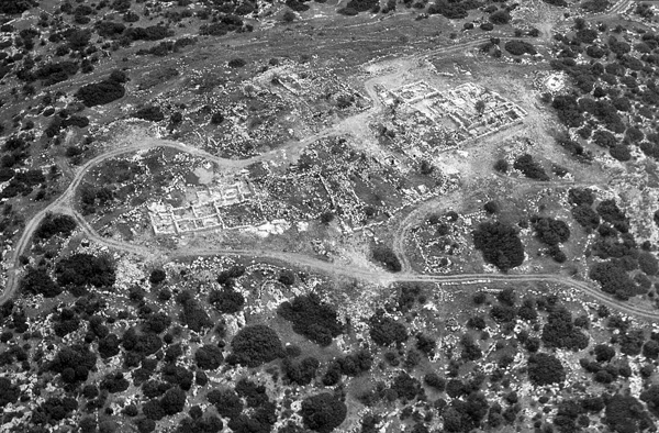
Ancient roads bordered by large fieldstones lead to the settlement from the east, south, and west. The narrow valleys situated to the north and south of the hill were cultivated and wells were hewn along them. Rainwater was collected in cisterns located in and near the built-up area of the site. Agricultural terraces were built along the slopes surrounding the settlement. Winepresses, watchtowers, stone quarries, rock-cut tombs, and other installations were located on the rocky outcrops among the terraces.
The site was excavated during three seasons from 1999 to 2001 by B. Zissu and A. Ganor on behalf of the Israel Antiquities Authority.
EXCAVATION RESULTS
THE PERSIAN PERIOD (PHASE I). The earliest phase of settlement was at the end of the Persian period, as attested by pottery fragments and coins from the second half of the fourth century BCE, including minute silver coins of the yehud type, a coin apparently minted in Babylon, and imitations of Athenian drachms and tetradrachms. No buildings were preserved.
THE HELLENISTIC PERIOD (PHASE II). Remains of Hellenistic period walls that were integrated into later structures and some cisterns have been preserved from this period. It is difficult to assess the shape and extent of the settlement, since many structures were dismantled or incorporated into later buildings. The rich numismatic assemblage is composed of a few silver and several bronze coins of the Ptolemies and the Seleucids, and hundreds of prutot of the Hasmonean rulers.
One or two of the ritual immersion baths (mikvehs) were probably installed during the Hasmonean period. The ceramic assemblage, consisting exclusively of locally produced pottery, and the abundance of Hasmonean coins suggest that Jews inhabited the site.
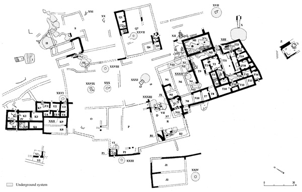
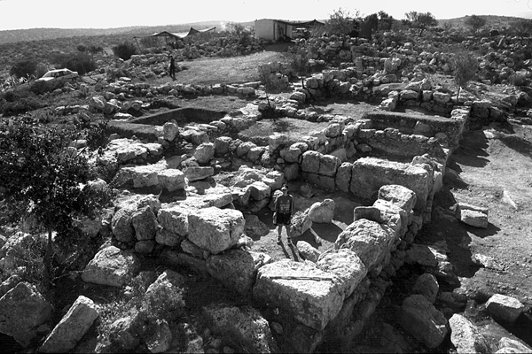
THE EARLY ROMAN PERIOD (PHASE III). During the first half of the first century CE, extensive building activities took place throughout the site. The village, which reached an area of c. 2.5 a., most likely attained its greatest extent in the decades preceding the First Jewish Revolt against the Romans. New well-planned residential quarters were constructed, enclosing two central public squares (c. 17 by 45 m). Narrow lanes led from the public squares to the buildings of the quarters. These buildings included central courtyards surrounded by rows of lateral rooms; walls of large nari stones; and outer corners and architectural elements, such as lintels, doorposts, and window frames of large, finely trimmed nari blocks. The residential rooms along the perimeter of the settlement are adjacent to one another, forming a continuous external wall built of large stones, which was apparently intended to provide security. The two westernmost rooms of building K were built of large and well-dressed ashlars, forming a stronger rectangular structure (7 by 10 m), probably used as a defense tower controlling the approach from the west. Rainwater running off roofs and open spaces was drained into at least 12 cisterns and 4 mikvehs.
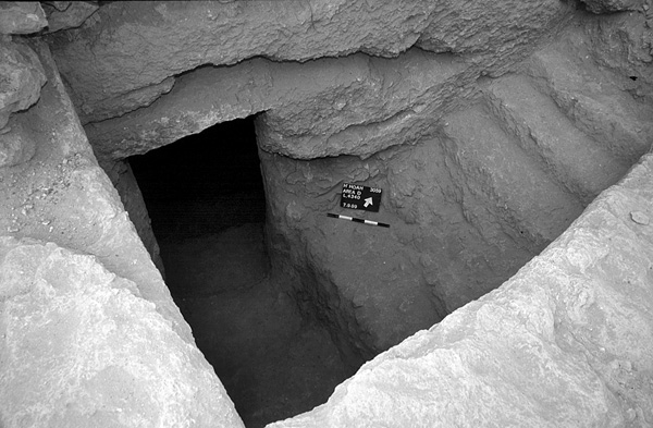
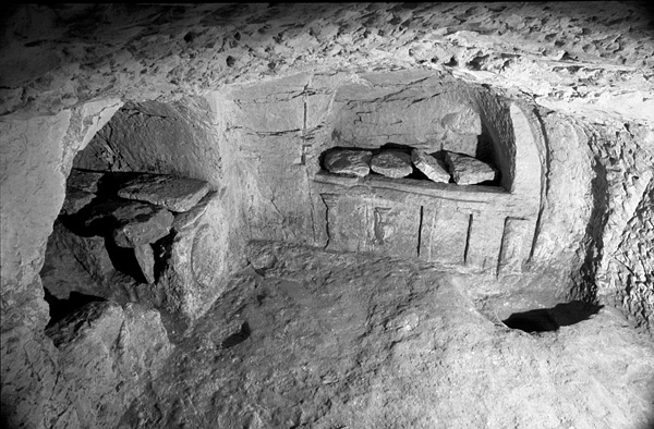
Beneath some of the dwellings small underground installations were hewn, each including a vertical or stepped entrance shaft and a short twisting tunnel, at the end of which are one or two small chambers. These are characteristic components of hiding complexes, common in the Judean foothills. Some of these installations were found sealed and containing diagnostic assemblages of finds from the first century CE.
The residents of the village in the first century CE were Jews, as attested by the mikvehs, the fragments of stone vessels, and the practice of secondary burial in limestone ossuaries. The ceramic assemblage is composed almost exclusively of locally made vessels of types common in Jerusalem and Judea during this period.
Burial caves are located along the northern and eastern slopes, beyond the village’s limits. Three tombs contain a square chamber with a standing pit and ledges on three sides. A larger burial system was also surveyed, consisting of a courtyard, a vestibule, and a square chamber with kokhim hewn into its walls. All the caves had been plundered. Similar tombs were common in Jerusalem and Judea during the first–beginning of the second centuries CE.
The settlement was partly destroyed in the First Jewish Revolt against the Romans (66–70 CE) and abandoned for a short period. Remains of the conflagration—ashes on floors—were noticed mainly in the eastern wing of building T. The coins include prutot from the second and the third years of the revolt (67–68 and 68–69 CE, respectively), a silver half-shekel from the third year, and a bronze coin from the fourth year (69–70 CE).
One of the cisterns (XII) had been put out of use and filled with hundreds of broken jars and cooking pots characteristic of the first century BCE to the first half of the first century CE. Twenty-eight fragments bear inscriptions written in Jewish script in black ink. Most of these ostraca contained single letters and numbers, presumably used in the keeping of financial records and the counting of agricultural produce.
THE PERIOD BETWEEN THE JEWISH REVOLTS, 70–135 CE (PHASE IV). The site was resettled during the period between the revolts against the Romans. The new settlers restored some of the courtyard buildings, adapting them to their needs by redividing the rooms, changing room functions, and raising floors. The renewed settlement occupied about half of the previously built-up area. The main residential buildings were arranged in an enclosed compound, measuring approximately 50 by 35 m, with rows of rooms grouped around three rectangular courtyards (buildings N, M, T, and possibly also Q). Outside of the built-up area were open courts, caves, and agricultural installations. A public building (M), most likely a synagogue (see below), was erected alongside and to the northeast of courtyard buildings N and T.
Subterranean complexes including burrows, chambers, and links to existing cisterns were installed underneath the residential buildings of this phase. Access to the complexes was typically via stepped or vertical shafts carved into the leveled floors of the rooms. At the head of the shafts recesses were designed for placing blocking slabs that concealed the opening. Subterranean complex XIV was found sealed. It contained a small assemblage of finds from the time of the First Jewish Revolt and many finds from the Second, including characteristic Judean oil lamps and three bronze coins that were restruck by the rebel administration (one from 132–133 CE and two from 134–135 CE). Five imperial denarii concealed during this revolt were uncovered. One denarius of Vespasian (dated 71 CE) and one of Hadrian (119–138 CE) were found among the outer stones of the westernmost corner of the village. Three denarii, one of the undated series from the Second Jewish Revolt and two minted by the emperors Vespasian (72/3 CE) and Trajan (101/2 CE) respectively, were discovered among the outer stones at the easternmost edge of the site.
The residents of the settlement took part in the Second Jewish Revolt. At the end of the revolt, the village was violently destroyed, as evidenced by the excavation finds. These include a burnt layer, uncovered on the floors of the rooms in the center of the site and containing a denarius of the Bar-Kokhba administration from the second year of the revolt. Mikveh XI was used for a mass burial, and contained the skulls and bones of at least 12 individuals, apparently slaughtered during the conquest of the settlement. Cut marks on a neck vertebra indicate that at least one individual was beheaded by a sword. The human bones were mixed with ashes and a well-dated assemblage of finds. The fate of this village was similar to that of many other settlements in Judea that took an active part in the revolt. They suffered large-scale devastation when reconquered by the Romans.
The Public Building (Structure M). The public building is part of an architectural complex including a broad hall (M1), a vestibule accessed from the west and east (M2), an outer open court (M3), an inner courtyard (T9), and a mikveh (XI). A single entrance gave access to hall M1; the opposite wall of the hall faced Jerusalem. This orientation is significant, as the hall was most probably erected after the destruction of the Second Temple, when the shmoneh ‘esreh (or ‘amidah) prayer was standardized and the worshipper uttering the prayer was required to face Jerusalem (J.T. Berakhot 4:6, D, E, F). The walls of the rectangular hall (c. 13 by 7 m long; 0.9 m thick) were built of two faces of dressed blocks with a fill of stone rubble. They were preserved to a maximum height of five courses. The ceiling was probably supported by three round columns, each consisting of several drums topped by a Doric-like capital. One capital and one drum made of the local nari stone were found in secondary use in the adjacent room T4. The columns rested on square stone pedestals. Only two pedestals and the foundation of a third remained in situ, in the center of the floor of the hall. Apparently a rather plain building, it had no remains of a Torah shrine, artistic representations, inscriptions, or mosaics.
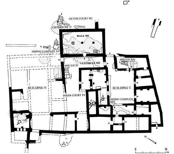
An open court (M3) flanked by a rock-cut bench is located on the northeast side of hall M1. An inner courtyard (T9) with a rock-cut stepped corridor descending into a large mikveh (XI) is on the opposite side of the hall. A stepped corridor cut into the corner of hall M2 gives access into a public hiding complex (XV) installed beneath the building. This corridor was formerly the stepped entrance into a mikveh put out of use during the building’s construction. Three small hiding complexes, each one consisting of a shaft, a burrow, and a small chamber, were attached to the complex. These were joined by means of longer burrows to two large subterranean water reservoirs.
A mixed assemblage of finds from the Hellenistic and Early Roman periods was found in the looted complex, including a prutah from the second year of the First Jewish Revolt, oil lamps, and other finds from the Second Jewish Revolt. It is assumed that public building M was the community’s synagogue between the two revolts. It was used until the end of the second of the revolts. During the Late Roman period (phase V, below) it was restored and its internal space was reorganized.
THE LATE ROMAN–EARLY BYZANTINE PERIODS (PHASE V). Soon after 200 CE, the ruined village was resettled and restored by new residents, perhaps of pagan origin. This new phase continued through the fifth century CE and was not accompanied by significant architectural alterations. The underground complexes were filled with dirt and debris and blocked off. A burial chamber decorated with schematic carvings was installed within a former subterranean complex. Four winepresses cut into rock in earlier periods were refurbished and reused.
BOAZ ZISSU, AMIR GANOR
INTRODUCTION
Ancient roads bordered by large fieldstones lead to the settlement from the east, south, and west. The narrow valleys situated to the north and south of the hill were cultivated and wells were hewn along them. Rainwater was collected in cisterns located in and near the built-up area of the site. Agricultural terraces were built along the slopes surrounding the settlement. Winepresses, watchtowers, stone quarries, rock-cut tombs, and other installations were located on the rocky outcrops among the terraces.