
Giv‘at ha-Oranim
THE SITE
The Chalcolithic site of Giv‘at ha-Oranim lies on a rocky hill, 130 m above sea level at its highest point, 15 km northeast of Ben Gurion Airport and 3 km east of Shoham, on the route of the Trans-Israel Highway (Route 6). The hill slopes moderately on all sides but the southern, which drops sharply toward
EXCAVATIONS AND SURVEYS
I. Shavit of the Israel Antiquities Authority surveyed the site in 1994 and described the remains of small quarries, two basins, a rock-cut winepress, and agricultural terraces from the Byzantine period. No mention was made of Chalcolithic remains. In October 1995, a second survey was conducted under the direction of E. Oren and N. Scheftelowitz of the Institute of Archaeology, Tel Aviv University. With the exception of a single body sherd, no Chalcolithic remains were encountered. In 1996–1997, two excavation seasons were conducted. An area of c. 2.5 a. within the c. 100 m-wide, north–south strip of the planned road was excavated.
EXCAVATION RESULTS
Discovered in the 1996–1997 seasons were underground complexes including caves, shafts, pits, and graves from the Chalcolithic period, as well as Byzantine agricultural installations, walls, and an arcosolium tomb.
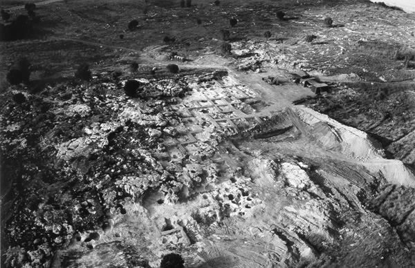
THE UNDERGROUND COMPLEXES. Nine multi-chambered caves were found at Giv‘at ha-Oranim. These were natural karstic caves enlarged and adapted to human needs for living, storage, and burial. They are in a bedrock ridge that extends c. 200 m along the hilltop from northeast to southwest. Seven would have been suitable for habitation. The complexes consist of round rooms of various sizes connected by hewn openings or corridors. Access to some of these complexes was via hewn openings in their roofs. In most, the leveled bedrock was utilized as the floor, however some have evidence of compacted lime floors. Niches and pits were dug into the floors. The finds in the caves include a large quantity of complete ceramic vessels and sherds, basalt implements, flint tools, metal artifacts, and other small finds, together with human and animal bones.
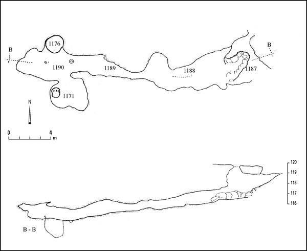
The two uninhabitable caves each had a single entrance from the side. Cave 1185 is c. 27 m long and comprises four spaces: a vestibule, an outer room, a corridor, and an inner room. Finds include pottery, basalt implements, and human bones. Cave 1186 consists of a central space and an inner niche. Pits containing storage jars were found in both caves.
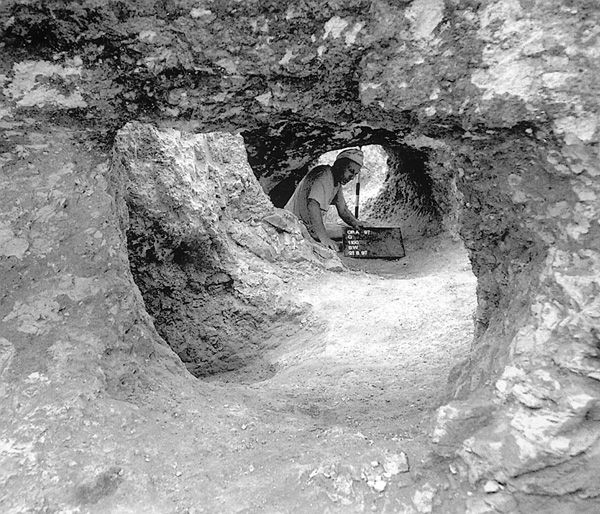
PITS. Pits excavated in the bedrock are the most common feature at the site. These were mostly scattered in areas within and outside the courtyards of the habitable caves. They are found as separate features or as components of a pit complex of two to more than ten interconnected pits. All were dug into the bedrock. Only in one case was a pit lined with stone. They may be divided into five main types: (1) bell-shaped—characterized by a flat bedrock floor, rounded walls, and a mouth of smaller diameter than the floor; (2) barrel-shaped—identical to the first group except that the rim is of the same diameter as the floor; one pit of this type was stone-lined; (3) deep pits (or shafts)—similar to those of the first group, but over 3 m deep; only three pits of this type were found at the site; (4) shallow pits—less than 40 cm deep; and (5) irregularly shaped pits. Most of the pits were filled with earth, stones, pottery sherds, and other small finds, reflecting their final stage of use as refuse pits. They may have originally been utilized for refuse disposal, or for storage, working crafts, or cooking.
BURIALS. Human bones representing 15 individuals were found in 15 archaeological features in the caves and pits. A few bones were recovered in most of these, however there were several cases in which only a single bone was found. The state of preservation was very poor and burial practices were verifiable in only three examples. Consequently, no comprehensive study was undertaken and the results are generally inconclusive regarding the age or sex of the individuals. In several burials the deceased were laid in a contracted position and were generally accompanied by pottery, basalt implements, flint, bone tools, and animal bones.
INSTALLATIONS. Several rock-cut installations were found in the western part of the site and in the bedrock near caves 1185 and 1186, as well as above some of the caves and on the eastern side of the site. There are several types of installations, including cup marks and cup mark series, basins, and surfaces for crushing and pressing (grapes or olives).
SMALL FINDS. Small finds include pottery, groundstone, and copper objects, in addition to bone tools, spindle whorls, loom weights, and two small rectangular mother-of-pearl pendant plaques, perforated on the upper part.
Pottery. The ceramic assemblage consists of storage, cooking, and serving vessels of various types and sizes: pithoi, storage jars, hole-mouth jars, bowls (mostly V-shaped in different sizes), churns, spoons, goblets, and fenestrated bowls. The vessels were decorated with paint, usually red, in bands or geometric patterns; some were adorned with impressions, incisions, or a plastic decoration. The majority of the pottery assemblage from the site is dated to the late Chalcolithic period and may be classified as Ghassulian ware.
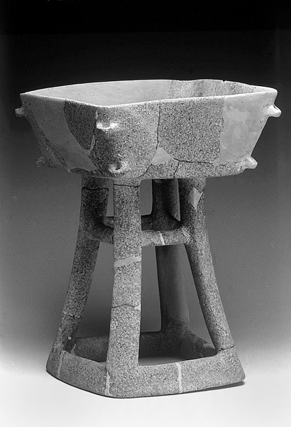
Groundstone. A large assemblage of stone vessels was found at Giv‘at ha-Oranim. Limestone is readily available in the immediate vicinity of the site. A total of 85 whole and fragmentary limestone vessels were found, including 18 bowls, 4 mortars, 8 grinding stones, and 7 querns. Several hundred whole and fragmentary basalt bowls and pedestal bowls were retrieved. Most are V-shaped bowls with straight or flaring walls, rounded or pointed rims, and thick bases of 4–7 cm. Pedestal bowls occur in small and medium sizes, and have three or four triangular legs. Sub-types include a bowl with three legs with a thick band between the stand and the base that is decorated with circular incisions; and a square pedestal bowl, c. 0.5 m high, with two pairs of loop handles at its sides. The basalt vessels are highly polished, most fragments plain while a few have incised herringbone patterns or a triangular decoration on the inner side of the rim. There is no evidence for any manufacture of basalt vessels at the site. They arrived to the site as finished products, imported from areas some 100–200 km away. Other stone objects include mace heads, some made of haematite and manganese-oxides, pierced stones, and hammer stones.
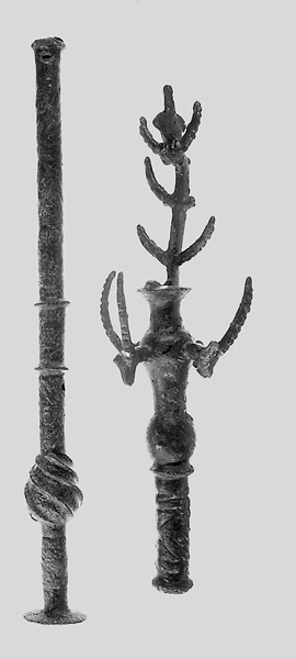
Copper Objects. Twenty-four copper objects were found. These include three stands, two crowns, one “scraper,” four mace heads, three axes, three adzes, and two pins. They are similar to items found in the Cave of the Treasure in
SUMMARY
Giv‘at ha-Oranim belongs to a group of contemporary Chalcolithic sites located within a 3 km radius (Shoham, Qula, and Tinshemet Cave) recently added to a list of sites excavated in the region beginning in the 1940s (Lod, Wadi Rabah, and
NAAMA SCHEFTELOWITZ
THE SITE
The Chalcolithic site of Giv‘at ha-Oranim lies on a rocky hill, 130 m above sea level at its highest point, 15 km northeast of Ben Gurion Airport and 3 km east of Shoham, on the route of the Trans-Israel Highway (Route 6). The hill slopes moderately on all sides but the southern, which drops sharply toward
EXCAVATIONS AND SURVEYS
I. Shavit of the Israel Antiquities Authority surveyed the site in 1994 and described the remains of small quarries, two basins, a rock-cut winepress, and agricultural terraces from the Byzantine period. No mention was made of Chalcolithic remains. In October 1995, a second survey was conducted under the direction of E. Oren and N. Scheftelowitz of the Institute of Archaeology, Tel Aviv University. With the exception of a single body sherd, no Chalcolithic remains were encountered. In 1996–1997, two excavation seasons were conducted. An area of c. 2.5 a. within the c. 100 m-wide, north–south strip of the planned road was excavated.