
Jarmuth, Tel
EXCAVATION RESULTS
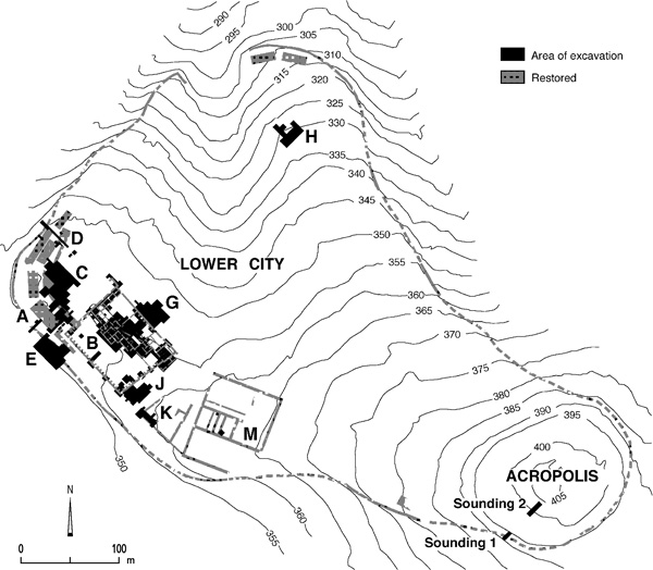
During eight seasons of excavations (1992–2006) directed by P. de Miroschedji of the Centre de Recherche Français de Jérusalem and the Institute of Archaeology of the Hebrew University of Jerusalem, work was completed in area G, continued in area B and sounding 2 on the acropolis, and commenced in areas J–N.
THE LOWER CITY. In the lower city, the main periods of occupation in the Early Bronze Age I–III were recognized during the first eight seasons of excavations. An occupational phase subsequent to the Early Bronze Age IIIB, and thus termed Early Bronze Age IIIC, was identified in area B, where it corresponds to palaces B2 and B1; it is also represented in areas G, H, and J. The phase marks the very end of the Early Bronze Age at Tel Jarmuth.
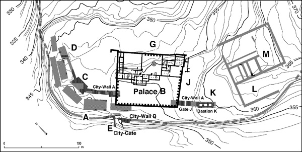
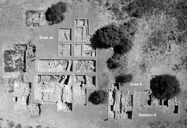
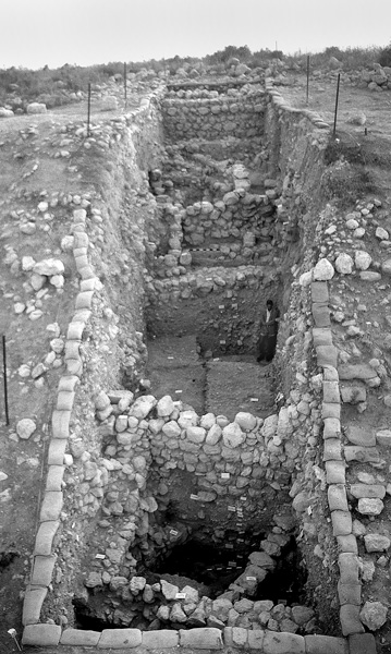
THE FORTIFICATIONS. Further excavations contributed to a better understanding of the plan and organization of the fortifications. Fortification wall A (phase I of the fortifications, Early Bronze Age II) was partially exposed along the western front of the city in areas Bd, Jc, and K, where it is 6.4 m thick. It had inner chambers reached from the interior of the city through an opening followed by a narrow staircase. It was reinforced on the exterior by huge bastions. Bastion K (still only partially excavated) measures 20 m by 8.5 m, is built of walls 2.1–2.6 m thick, and has three communicating inner chambers. A glacis made of earth, stones, and layers of lime plaster rests against its outer face at an angle of about 45 degrees. North of bastion K, gate J is a simple opening, 2.6 m wide, giving access to a curved street. It was blocked with solid masonry, probably when the outer fortification wall B was built (phase II of the fortifications, late Early Bronze Age II) and the space between walls A and B was filled up with alternating layers of lime plaster and ash, earth, and stones.
Excavations in sub-areas Bg and Bf revealed that one of the monumental platforms ascribed to phase III of the fortifications had been dismantled when palace B1 was constructed, while another assumed platform was actually a huge reinforcement built around the western corner of palace B1.
THE PALACES. The large construction in area B identified in 1990 as an Early Bronze Age III public building was the major focus of excavations in recent seasons. Four strata have thus far been identified in this area. Presently the earliest is stratum B-3, which is ascribed to the Early Bronze Age IIIB; it consists of a series of dwelling houses contemporaneous with strata C-1, G-3, and J-2. Stratum B-2 corresponds with palace B2, which covers the leveled remains of the preceding stratum; it is tentatively equated to a late phase of stratum G-3. Stratum B-1 is represented by palace B1, built immediately above palace B2 and found directly under the present surface of the tell; it is contemporary with strata G-2 and J-1. The northeastern quarter of palace B1 has been almost completely destroyed by Byzantine and later agricultural terraces, which are labeled stratum B-0.
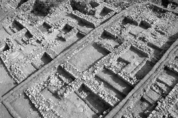
Dated to the Early Bronze Age IIIC, palace B2 was built on an area previously occupied by the domestic dwellings of stratum B-3, which were deliberately destroyed to make room for the new palace. Its size can be estimated at c. 1,750 sq m, although its limits remain unknown. It was founded in part on an artificial terrace. Excavations have revealed a densely built compound with at least 26 rooms and courtyards, including at least four small inner courtyards with pebbled floors, probably serving as light shafts; and a large hall with lateral benches, possibly an assembly hall, on its southwestern side.
The building techniques and planning of palace B2 are far superior to those used in contemporary domestic buildings and clearly belong to palatial architecture. They are, however, less sophisticated than those implemented in the subsequent palace B1.
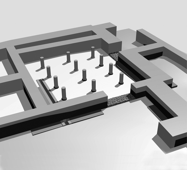
Palace B2 had apparently a short existence. It was destroyed and entirely leveled for the construction of a larger and more ambitious building, palace B1, also dated to the Early Bronze Age IIIC. Almost square in plan, palace B1 measures 84.5 by 72.1 m and covers about 6,000 sq m (c. 1.5 a.). It is the largest building complex known from this period in the entire Levant. Its construction involved a widespread remodeling of the urban layout of this part of the site. The extensive ground preparation consisted of the partial leveling of fortification wall A and the removal of the stratum J-2 dwellings. The palace was clearly set apart from its surroundings, as indicated by the thickness of its peripheral wall; streets run on the other side of the wall. The large-scale architectural planning of the palace employed a grid based on a multiple of a 52.5-cm cubit; all walls, doors, buttresses, room lengths, and room widths conform strictly to this cubit, similar to the “royal” Israelite cubit and the Egyptian royal cubit. This cubit is attested here for the first time in Canaanite architecture.
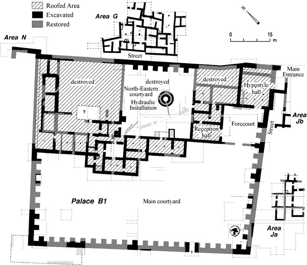
The quality of the construction technique is remarkable, as indicated by lime-plastered walls and floors, elaborate doorjambs and thresholds suggesting the use of wooden frames holding the door swivel, large and carefully worked stone bases to support wooden pillars, staircases leading to an upper story or the roof, and a system of channels and cisterns.
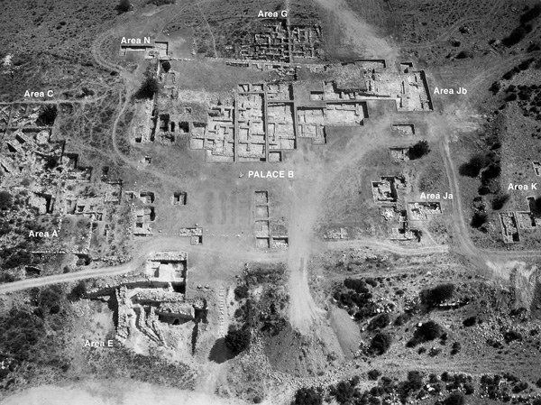
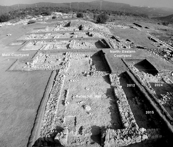
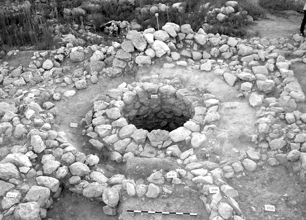
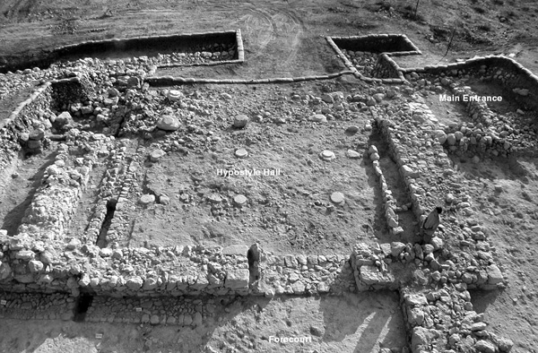
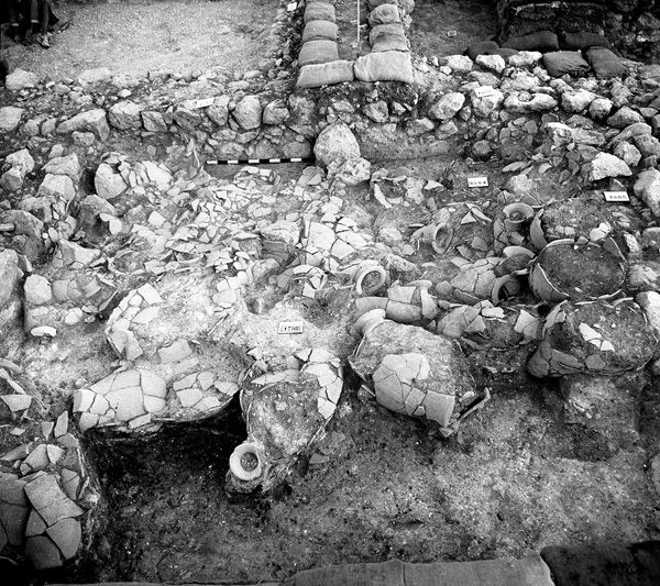
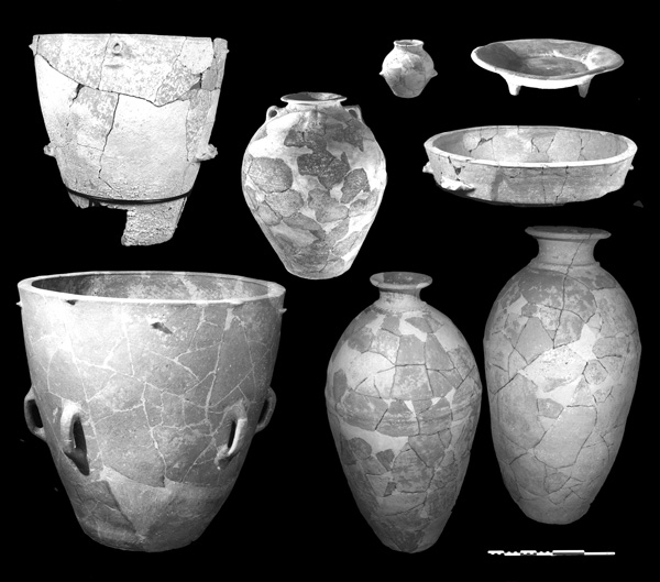
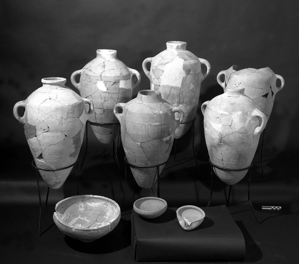
Palace B1 may originally have included some 50 rooms, corridors, and small inner courtyards, of which almost 40 were identified in the excavations. They are organized in relation to two large courtyards, the largest occupying the southwestern half of the palace. Five functional areas were recognized or reconstructed within the palace: (1) The official area is located to the east. It is composed of the main entrance to the palace, 2.6 m wide and preceded by steps, a large hypostyle hall containing 12 columns resting on large stone bases, a forecourt, and a sizeable reception hall. The latter communicated with a series of rooms and presumably an upper story. (2) The administrative area consists of the northeastern courtyard and some 20 storerooms on its periphery; the storerooms have yielded nearly 150 storage jars. Several water channels converged toward a hydraulic installation near the center of this courtyard, still under excavation. It consists of a circular shaft, 4.20 m deep and 1.5 m in diameter, giving access to a rock-hewn cistern, the oldest installation of this type known in the Levant. (3) The domestic area appears to have been situated to the northwest, as suggested by the discovery of a kitchen with three hearths. This area was almost completely destroyed by Byzantine terracing. (4) The residential area was presumably located on an upper story that did not survive. (5) It is assumed that the main courtyard was used as a stockyard.
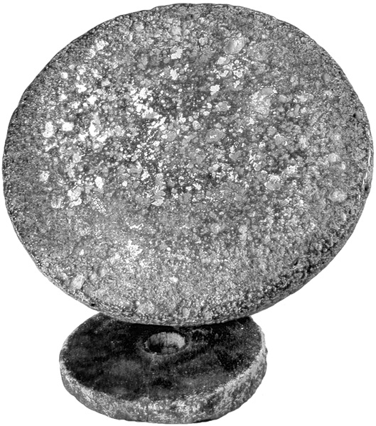
There is no evidence of a violent destruction marking the end of palace B1. All indications point to its peaceful abandonment, the inhabitants having removed all their valuable belongings and leaving behind mainly storage vessels and a few objects, such as a complete basalt tournette, found in two parts. The building was then left to decay, as shown by the stratification of the debris in several rooms.
The dimensions, quality of construction, and inner arrangement of palace B1 suggest that it was both the seat of a political power and a storage center for goods produced within a palatial domain. It represents a new element in the archaeology of the Early Bronze Age in southern Canaan. The only contemporary building presently comparable to it is building 3177 of stratum XVI at Megiddo, whose palatial function now appears likely. The similarities between the two buildings suggest a common architectural tradition, ultimately inspired by Old Kingdom Egypt.
THE TERRACES TO THE SOUTHEAST. Surface observations and limited soundings suggest the presence of large scale buildings on terraces K, L, and M to the southeast of palace B1. On terrace M, walls built to widths of 2.10 m, 2.60 m, and even 3.20 m were traced over a length of up to 50 m, with foundations more than 4 m deep. The nature of these constructions remains uncertain. Floors have mostly been eroded away, although one floor has yielded late Early Bronze Age III pottery.
DWELLINGS. Dwellings were exposed in areas B, G, J, and K. In area G, stratum G-3 was explored and strata G-4 (Early Bronze Age III) and G-5 (Early Bronze Age II) identified. In area B, stratum B-3 is the continuation of stratum G-3 to the southwest, under palace B2. Cleared in sub-area Bd was part of a house containing pillar bases with deep stone foundations located along the walls and in the corners, an arrangement also attested in contemporary Byblos. In area Ja, dwellings over two strata, J-1 and J-2, were excavated, the latter having suffered a violent destruction, yielding a large quantity of Early Bronze Age IIIC vessels crushed on the floor under the collapsed plastered ceiling.
THE ACROPOLIS. The deep sounding on the acropolis was extended to 120 sq m and completed in 1997 under the supervision of M. Jasmin. Bedrock was reached at a depth of 7 m below the surface. Seven strata were identified. The lowermost stratum, Acr-7, was found badly eroded and resting on bedrock, containing no structural remains. It was dated to the Early Bronze Age II–III. At the top of the fill, a few Middle Bronze Age II sherds suggest a small occupation on the acropolis in the second quarter of the second millennium. Dated to the Late Bronze Age IIB, stratum Acr-6 has yielded some Mycenean and Cypriot ware (including white slip II and base ring II), but no architecture. The next three strata, Acr-5 to Acr-3, correspond to a substantial Iron Age I occupation marked by a succession of domestic dwellings associated with abundant and well-stratified archaeological assemblages covering the twelfth–eleventh centuries BCE. The presence of bichrome ware in stratum Acr-4 should be noted.
The absence of Iron Age II remains is noteworthy and problematic in light of the traditional identification of the tell with the biblical Jarmuth of Jos. 10 and 15 and Neh. 11:29. Perhaps it should be concluded that Jarmuth was then a very small settlement located on the other side of the acropolis, or rather that the toponym Jarmuth then referred to another site located in the vicinity. Stratum Acr-2 dates mainly to the Persian, Hellenistic, and Roman periods. It is represented by agricultural terraces, a large building occupying part of the top of the hill, and a Roman domestic dwelling associated with a subterranean cistern. Finally, stratum Acr-1 corresponds to the ruins of a Late Roman–early Byzantine village, presumably the Iermochos of Eusebius of Caesarea.
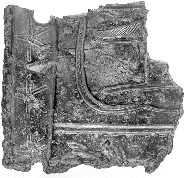
A HOARD OF EGYPTIAN BRONZES. A hoard of Egyptian bronze objects was discovered in a heap of stones above the ruins of palace B1. It is comprised of 16 objects, of which 15, found lumped together, were probably buried in a bag. They include a fragment of an inscribed plaque, a socketed hoe, a furniture fitting (?), and 13 fragments of bronze sheets. Measuring 12.4 by 11.9 by 0.9 cm, the plaque has only a few remaining hieroglyphs, which are exceptionally well engraved. They were read as dd mdw in […] hr (?) […], “these are the words said by (…) on (?) (…),” by O. Goldwasser, who dates the inscription to the Nineteenth Dynasty and believes the plaque was originally nailed on a large naos in an Egyptian temple of Late Bronze Age Canaan. The hoe is typical of the Nineteenth–Twentieth Dynasties. The bronze sheets were found carefully folded and include a nave cap. They were identified by B. Brandl as parts of the revetment of a chariot.
The objects of this hoard are a homogeneous group datable to the Nineteenth Dynasty. Since Jarmuth was then a modest settlement that could hardly have possessed a major Egyptian cultic building, it is likely that these objects were brought from another site by a villager who hid them under a pile of rocks above the Early Bronze Age palace. This possibly occurred during the Late Bronze Age II or even as late as the Middle Ages. The hoard should thus be interpreted as plunder rather than scrap collected by a smith.
PIERRE DE MIROSCHEDJI
EXCAVATION RESULTS
During eight seasons of excavations (1992–2006) directed by P. de Miroschedji of the Centre de Recherche Français de Jérusalem and the Institute of Archaeology of the Hebrew University of Jerusalem, work was completed in area G, continued in area B and sounding 2 on the acropolis, and commenced in areas J–N.
THE LOWER CITY. In the lower city, the main periods of occupation in the Early Bronze Age I–III were recognized during the first eight seasons of excavations. An occupational phase subsequent to the Early Bronze Age IIIB, and thus termed Early Bronze Age IIIC, was identified in area B, where it corresponds to palaces B2 and B1; it is also represented in areas G, H, and J. The phase marks the very end of the Early Bronze Age at Tel Jarmuth.