
Khirbe, El-
INTRODUCTION
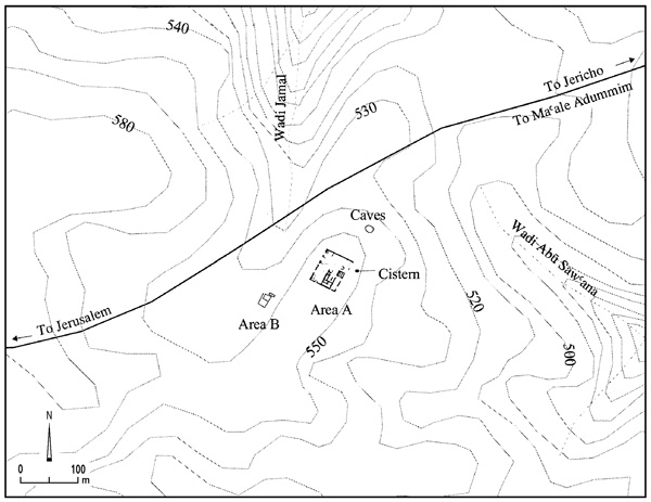
El-Khirbe is located west of Ma‘ale Adummim on a rocky hill, 550 m above sea level. The hill is surrounded by steep slopes on three sides, but the moderate slope on the southern side affords easy access to the site. Agricultural areas extend to the west. The ancient Jerusalem–Jericho road runs to the north. The site was first surveyed by E. Dinur, who uncovered finds from the Iron Age and Persian (?), Roman, and Byzantine periods. Flint tools of the Chalcolithic period and the Early Bronze Age were also recovered. The site was excavated in 1995 under the direction of H. Hizmi, on behalf of the Staff Officer for Archaeology in Judea and Samaria. Four main elements were uncovered at the site: a fortress on the summit of the hill (area A), a cistern, dwelling caves, and a Byzantine inn (area B).
EXCAVATION RESULTS
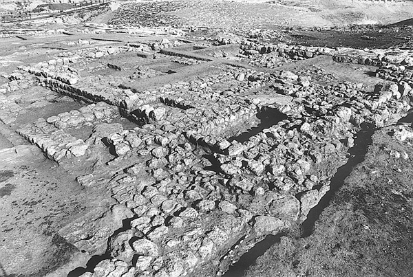
THE IRON AGE. The fortress on the summit was roughly 0.5 a. in area. Its walls, 1.4 m wide, were constructed of two rows of stones, trimmed on their outer faces, and a stone fill. The corners of the walls were built of large stones and remain standing to a height of two to three courses. The eastern wall was only partly preserved; to the east of it, other fragmentary walls were found. The entrance to the enclosure was not uncovered but it is assumed to have been situated on the eastern side.
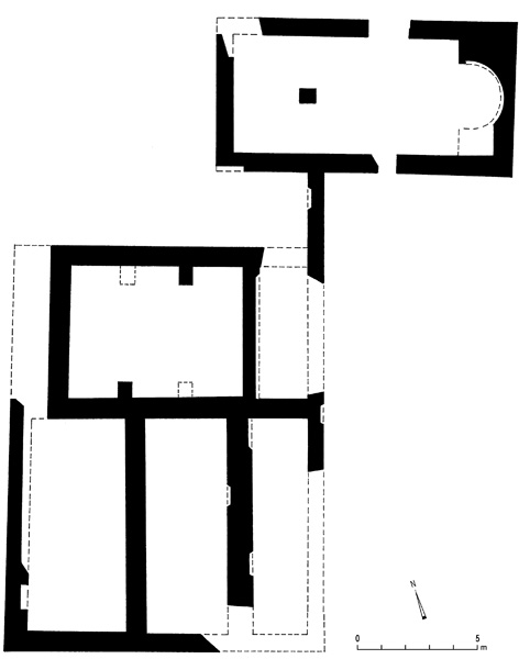
Three construction phases were distinguished in the area of the fortress. In phase 1, ascribed to the eleventh–tenth centuries BCE and predating the fortress, five partially preserved buildings were uncovered. The two more complete ones may have been of the typical Israelite three-room house plan. In phase 2, dated to the tenth–ninth centuries BCE, the fortress was constructed. It consisted of a peripheral wall surrounding an open courtyard and a building in the southeastern corner. Soundings revealed installations sunken into the ground, containing mixed Iron Age and Byzantine pottery; and a semicircular, stone-built installation, its floor paved with small stones, on which lay Iron Age pottery. The building in the southeastern corner of the fortress was 660 sq m (30 by 22 m), with walls 1.20 m wide consisting of rows of medium-sized stones dressed on their outer face. The building is divided into three spaces: a long hall (A) to the east, three units (B, C, D) to the west, and two units (E, F) to the north. In phase 3, dated to the eighth–sixth centuries BCE, changes were made within the building and to the fortress’ peripheral wall, which was strengthened and widened, and an additional room in the elongated western space was built.
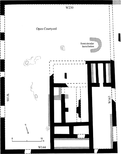
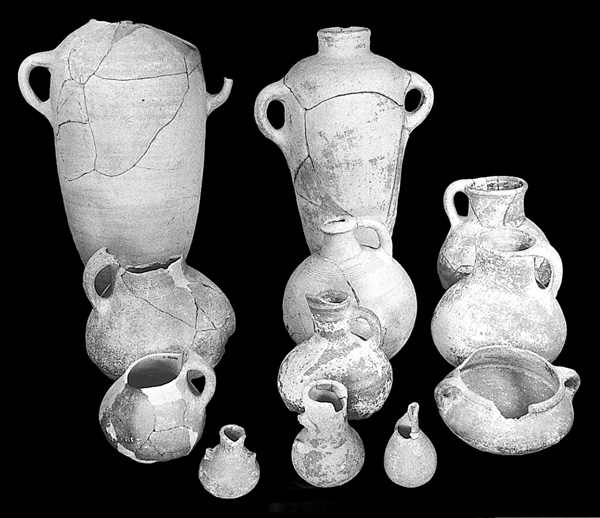
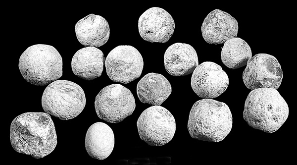
A number of intact vessels were found in situ in one of the rooms adjoining the western enclosure wall of the fortress. These vessels, dated to phase 2, include bowls, cooking pots, decorated globular jugs, a pyxis, and Late Bronze Age “Canaanite-type” jars of the collared-rim family. From phase 3 were vessels typical of many sites in the south of the country dated to the eighth–sixth centuries BCE, including kraters and burnished bowls. An interesting find is a group of 23 slingstones of 4 different types of material: flint, limestone, quartz, and basalt. They are round, 7 cm in diameter, and weigh about 450 g.
At the foot of the eastern slope, about 70 m from the fortress, was a rock-hewn, bell-shaped cistern, entered via a flight of steps, with a collapsed roof. It was the only water storage installation encountered at the site. In the northern slope of the hill, next to the Jerusalem–Jericho highway, were two dwelling caves whose roofs had collapsed. They contained Iron Age and Byzantine period pottery.
Few Iron Age I sites or fortresses have been uncovered to the north or south of Jerusalem. El-Khirbe therefore represents an important link in the understanding of the network of settlements around Jerusalem. It may have been one of the settlements established to defend the border of the Judahite kingdom. While there is little unity in the plans of these fortifications, each contains certain basic features also present at el-Khirbe: a peripheral wall, an open courtyard, and a main building reflecting the Israelite house plan.
THE BYZANTINE PERIOD. A later building phase of the Iron Age fortress was discerned, in which a stone course was added to the peripheral wall. The addition was carelessly executed and deviated in several spots from the early line of the wall. The meager finds attest to a temporary occupation of the structure, cistern, and caves. On the western slope of the hill an inn was constructed over an area of 500 sq m. It consisted of a chapel and a large building with a dwelling area and service rooms. The chapel (12.5 by 6.5 m), located in the northern part of the inn, was built of plastered stone walls. Two entrances, one in the northern wall and one in the southern, allowed access to the chapel from other parts of the inn. The chapel was composed of three parts—an apse, bema, and prayer hall—all paved in white mosaic, poorly preserved. The apse and the bema were raised about 0.60 m above the prayer hall and separated from it by a partition. A square pillar and several fragments of clay roof tiles were found in the prayer hall. South of the chapel was a complex of five rooms that served as living and service quarters. Their walls were preserved to a height of one or two courses. Tesserae recovered in the living quarters indicate that the floors were paved in white mosaic. Adjoining the chapel on the southern side were three parallel rectangular rooms; no doorways to the rooms were found. Among the finds in the inn were typical Byzantine pottery of the fourth/fifth–seventh/eighth centuries CE, glassware, a carved, burnt bone fragment, and several coins.
Although similar in plan to other Byzantine inns along the Jerusalem–Jericho road, the el-Khirbe inn differs in not being associated with a monastery. It was apparently one of the service facilities established to accommodate the large number of pilgrims visiting the Holy Land during the Byzantine period. The inn was constructed in the sixth century and remained in use until its abandonment at the beginning of the eighth century.
HANANYA HIZMI
INTRODUCTION
El-Khirbe is located west of Ma‘ale Adummim on a rocky hill, 550 m above sea level. The hill is surrounded by steep slopes on three sides, but the moderate slope on the southern side affords easy access to the site. Agricultural areas extend to the west. The ancient Jerusalem–Jericho road runs to the north. The site was first surveyed by E. Dinur, who uncovered finds from the Iron Age and Persian (?), Roman, and Byzantine periods. Flint tools of the Chalcolithic period and the Early Bronze Age were also recovered. The site was excavated in 1995 under the direction of H. Hizmi, on behalf of the Staff Officer for Archaeology in Judea and Samaria. Four main elements were uncovered at the site: a fortress on the summit of the hill (area A), a cistern, dwelling caves, and a Byzantine inn (area B).
EXCAVATION RESULTS
THE IRON AGE. The fortress on the summit was roughly 0.5 a. in area. Its walls, 1.4 m wide, were constructed of two rows of stones, trimmed on their outer faces, and a stone fill. The corners of the walls were built of large stones and remain standing to a height of two to three courses. The eastern wall was only partly preserved; to the east of it, other fragmentary walls were found. The entrance to the enclosure was not uncovered but it is assumed to have been situated on the eastern side.