
Marine Archaeology
The southern Levantine coasts have been a cradle for maritime civilizations since the Pre-Pottery Neolithic period. These coasts are the closest marine environments to the core areas in which plants and animals were first domesticated. The first agro-pastoral-marine subsistence systems (so-called “Mediterranean fishing villages”) emerged on these coasts during the ninth millennium
SUBMERGED PREHISTORIC SETTLEMENTS
Several Neolithic settlements dating from the ninth to the seventh millennia
THE PRE-POTTERY NEOLITHIC C SITE OF ‘ATLIT YAM. Recent excavations and surveys at ‘Atlit Yam have revealed stone-built structures, a megalithic installation, and 50 human skeletons. Seven kurkar megaliths (1–2 m high) were exposed arranged in a circle (c. 2.5 m in diameter) open to the northwest. Some of the megaliths are still standing upright, their lower parts imbedded in the clay and in a layer of small fieldstones; others are lying horizontally. The inner face of the standing megaliths is covered by a thick layer of gray travertine, attesting to the presence of a freshwater spring. Adjacent to the standing megaliths are several large stone slabs (1–2 m long) with numerous shallow cupmarks, apparently related to the standing megaliths; perhaps they functioned together in a ritual associated with the freshwater spring.

Some 20 m west of the megaliths, the foundations of two stone walls (0.5–0.8 m wide), set c. 1.6 m apart, run parallel for c. 50 m. The walls are constructed of two rows of fieldstones preserved to one course. Between them was a floor of small fieldstones. These remains could represent the ground floor of a two-storied corridor house. The upper floor was probably made of wood and functioned as a dwelling, while the lower floor housed the livestock.

In the center of the site were three large, oval kurkar megaliths (1.65–2.80 m long). Two of these were partially worked, with a groove cut on the circumference near one of the narrow ends, schematically conferring the shape of a human figure. The megaliths were probably chosen carefully to minimize the work needed to shape them. It is likely that this group comprises a ritual installation.
The archaeological finds indicate that the economy of the site was complex, based on the combined exploitation of terrestrial and marine resources: plant cultivation, livestock husbandry, hunting, gathering, and fishing. The ‘Atlit Yam site provides the earliest known evidence for an agro-pastoral-marine subsistence system on the Levantine coast—a Mediterranean fishing village.

SUBMERGED POTTERY NEOLITHIC SITES. Five Pottery Neolithic sites, Kafr Samir, Kefar Galim, Tell

MEDITERRANEAN HARBORS AND ANCHORAGES
The southern coast of the Levant has been a busy sea route for at least the past five millennia. The Mediterranean coast of Israel (c. 188 km long) is straight, with no islands or bays to provide natural shelter for watercraft during heavy storms. Running parallel to the shore on the Coastal Plain are several kurkar ridges, some of which are partly submerged, forming small islets and discontinuous reefs c. 150 to 600 m offshore that could provide partial protection to anchoring vessels. The shortage of natural shelters along the coast and the strong winter storms were a problem for local seafarers. Various solutions to the problem were put to use, demonstrated by the typology of the ports and anchorages enumerated below. These consist of stone-built harbors and several types of anchoring facilities based on natural geomorphological features. The typology of these harbors and anchorages is as follows: (1) A built harbor consists of stone-built breakwaters and keys. (2) A proto-harbor is a sheltered area usually situated on the lee side of a kurkar ridge, which is partly submerged at some distance offshore, with man-made improvements; remains of such features have been recorded at Caesarea, Apollonia-Arsuf, Yavneh-Yam, and Tel Ridan. (3) A deep-water anchorage (3–7 m water depth) is a kurkar ridge which is partly submerged, forming small islands offshore with no man-made modifications; such anchorages have been found at Achzib, Shavei
BUILT HARBORS. Recent preliminary excavations by A. Raban and H. Arad (University of Haifa) at ‘Atlit, on the south side of the northern mole, recovered wooden splinters from between the stones which were attributed by radiocarbon dating to the ninth century BCE. Other built harbors have been recently discovered at Acco and Caesarea (see those entries, in this volume).
ANCHORAGES AND ASSOCIATED SHIPWRECKS. Ashkelon Southern Open-Sea Anchorage. The construction of the modern Ashkelon marina and the expansion of the port and cooling pool of the Israel Electricity Company to the south of the city have resulted in the exposure for the first time of many ancient finds on the sea floor and beach. These findings can contribute to our understanding of the enigma regarding the existence of a port at Ashkelon.

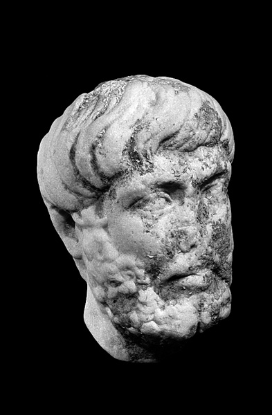
In the shallow waters along the shore near Tel Ashkelon (0–2 m deep), recent underwater surveys have revealed numerous marble and granite columns, capitals, and bases that had been transported by sea to Ashkelon for the construction of public buildings during the Roman period. Other Roman architectural elements, such as columns and capitals that were incorporated in secondary use into the Islamic period seawall (a stone-built wall on the sea side of the tell, reinforced by granite columns in secondary use), have fallen into the sea as a result of marine erosion that destroyed the wall. A group of bi-conical basalt millstones and 14 stone weights belonging to an olive-oil press, each weighing some 500 kg, were documented and mapped underwater. The millstones and stone weights that can be dated to the Roman and Late Roman periods were scattered along a strip 200 m long, 30 m from the present-day shore of the tell and buried at a depth of 1–1.5 m. Various items made of marble dating to the Roman and Byzantine periods were found, including columns, a decorated chancel screen, the bearded head of a life-size marble statue, the pedestal of a sculpture with only the feet intact and bearing a Greek inscription, and a life-size statue of a sheep whose head and forelegs are missing. These objects may have been deliberately destroyed and thrown into the sea by iconoclastic Muslims.
Remnants of shipwrecks and their cargos were found at depths of 3–6 m, 80–200 m offshore. Among the finds were stone and iron anchors, a large cargo of well-shaped catapult stones in various sizes, and a cargo of dozens of lead loaf-shaped ingots bearing inscriptions and weighing 80–100 kg each (of the eleventh–thirteenth centuries
In order to maintain an extensive maritime trade, suitable port installations were needed for merchant ships loading and unloading merchandise. In all the surveys carried out so far, no remnants of a built-up port have been found at Ashkelon. Furthermore, the historical descriptions do not mention with any certainty the existence of a port. Some even categorically refute its existence. The coastline in the area of Ashkelon is straight, sandy, and void of coves and inlets that could provide shelter for ships from winter storms or strong summer shoreward winds. Based on the morphology of the shallow continental shelf, the physical conditions of the coast, and the underwater archaeological remains, it may be that Ashkelon never had a built port. Seagoing vessels would have anchored in an open-sea anchorage situated a few hundred meters offshore, where the concentration of anchors was found. Transportation of goods and passengers to and from the ships would have been carried out in small boats. As the sandy beach is given to seasonal fluctuations, mobile windlasses and lifting devices, probably made of wood, were used to haul ships ashore for maintenance and repairs when the sea was calm. The millstones and stone weights were brought to the beach from local flour mills and olive-oil presses to be used as weights for holding down the mobile hauling devices. The wooden structures were weighed down by the perforated stones that were buried under the sand.
Ashkelon Northern (Mayumas) Open-Sea Anchorage. Following the construction of the marina for the modern city of Ashkelon, the coastal cliffs and the sea bottom along the northern beaches were eroded. North of the site of esh-Sheikh ‘Awad, a 500-m-long section of the cliff was exposed; it contained the remains of a coastal settlement with massive sea walls, monumental structures, and installations. The architectural remains include living floors, walls of buildings, installations, and the remains of a city wall constructed of two faces of dressed kurkar blocks with a mixture of fieldstones and cement between them. Six stone-built water wells (c. 1 m in diameter) were exposed on the shore. Many architectural fragments, broken marble basins, and marble bowls were recovered, as well as numerous sherds of Late Roman and Byzantine pottery vessels, mainly Gaza-type amphorae.
Scattered remnants of ships were discovered some 100–150 m from the shore, including stone and lead stocks of wooden anchors, two-armed iron anchors, and scores of composite two- and three-holed stone anchors. Some of the stone anchors bear inscriptions dating to the Byzantine and Early Islamic periods. There were also a few large (50–180 kg) stone anchors with one perforation dating to the Late Bronze Age. A Late Bronze Age shipwreck assemblage included stone anchors with one perforation, a bronze hatchet, and a spearhead. A Persian wreck assemblage included two stone stocks (1.2 and 2.1 m long) of wooden anchors and many fragments of basket-handled amphorae. Of the three Roman shipwreck assemblages discovered, one contained two iron anchors with their stocks next to them; lead weights, one of which bears an anchor in relief; various metal items, including bronze nails, a bronze oil lamp, a bronze incense shovel, a lead cauldron, a bronze ladle decorated with duck heads, a unique bronze trumpet (c. 0.8 m long), a unique lead stove that was used for cooking and heating water, and a set of scale weights composed of a lead core with a bronze coating, seven cylindrical and mushroom-shaped, of various weights, and one rectangular (20 kg) with a suspension ring. Another Roman shipwreck yielded three bronze figurines, one of Venus taking off her sandal, her eyes inlayed with silver; another of a naked bearded man (a satyr or Priapus) with a grotesque phallus, wearing a tall hat; and a seated monkey (2 cm high) with its hands covering its mouth. Other artifacts from the ship include lead tubes (of a bilge pump?), thin lead plaques with nail holes used to cover the ship’s hull, a huge bronze nail (0.75 m long), a set of bronze pulleys belonging to a power block, a shell-shaped cast object, and a lid decorated with two female heads. The cargo of the third Roman shipwreck included a bronze figurine of Mercury, an intact lead cooking pot (volume c. 40 liters), a steelyard, lead sheathings, and numerous bronze nails. Two Byzantine shipwreck assemblages contained two-armed iron anchors with their unattached stocks beside them, lead sheathings, and a cache of Byzantine bronze coins of 40 numia of the Constantinople and Nicomedia mints bearing busts of Justin and his wife Sophia. Also recovered were three sounding leads decorated with crosses and palm leaves as well as fishing hooks.

In view of these underwater finds, and the physical characteristics of the coastline, it appears that the fortified coastal settlement never had a proper built-up harbor, and sea vessels anchored in the open sea opposite the settlement. This site may perhaps be identified with Byzantine Ashkelon-Mayumas, mentioned in historical sources.

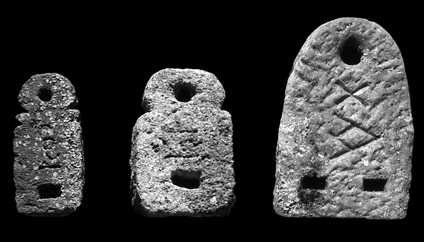
Yavneh-Yam Deep-Water Anchorage/Proto-Harbor. Yavneh-Yam was first settled during the Middle Bronze Age and continued to be occupied until the Middle Ages. Adjacent to the tell is a natural anchorage protected by kurkar reefs to the west, and two headlands to the south and north. Underwater surveys carried out by the University of Haifa and the Israel Antiquities Authority since 1980 have revealed shipwreck assemblages including dozens of stone anchors with one, two, or three perforations; lead fastenings; stone stocks of wooden anchors; and artifacts used onboard ship, such as a lead cooking stove, grinding stones, stone bowls, fishing equipment (bronze hooks, lead net sinkers, and sounding leads), and storage jars, amphorae, bowls, and cooking pots dating to the Late Bronze, Persian, Hellenistic, Roman, and Byzantine periods. A hoard of Bronze Age artifacts includes dozens of gold objects (beads, earrings, jewelry fragments, metal lumps, and jewelry-production waste), a cylindrical hematite seal of Syrian origin, 20 hematite weights, bronze spearheads, arrowheads and axes, and two figurines of the god Ba‘al. All these finds attest to intensive marine activity and a flourishing maritime trade. Most are of types produced in Israel or in the Eastern Mediterranean, although some were imported from more distant provenances. Yavneh-Yam was the only anchorage between the Sinai coast and Jaffa that could provide shelter for seagoing vessels. The archaeological evidence indicates that the anchorage was used almost continuously from the Late Bronze Age until the Middle Ages.
Apollonia-Arsuf Deep-Water Anchorage/Proto-Harbor. South of the ruins of Apollonia-Arsuf is a submerged kurkar ridge connected to the shore at its northern end. This ridge creates a relatively protected anchorage with a depth of 3–5 m. It was apparently artificially raised in some places by the addition of stones. The anchorage was surveyed by E. Galili and J. Sharvit (Israel Antiquities Authority) and E. Grossman (Tel Aviv University) during 1990–2003. Around 50 stone and iron anchors of different types were discovered, among them a single Byblos-type stone anchor with one perforation, dated to the Middle Bronze Age. In addition, artifacts associated with navigation and numerous fishing devices were recovered, including lead net sinkers, sounding leads, and stone rings for releasing entangled fishing gear. In the southwestern part of the anchorage, a cargo of bronze, stone, and lead artifacts was discovered, including scores of fragments of a life-size bronze statue of a male figure, a small bronze figurine of the goddess Minerva, and bronze nails. Three cargos of small and medium-sized ashlars made of kurkar were found in the anchorage, and two cargos on the submerged kurkar ridge. A few columns and architectural elements of various sizes, made of granite, marble, and kurkar, were retrieved on the ridge and in the anchorage area. Many potsherds were collected, including Byzantine amphorae, pithoi, fragments of “basket-handled” Persian amphorae, and vessels dating to the Persian, Hellenistic, and Roman periods; also recovered were broken glass ingots, probably originating from the local glass industry. Judging by the archaeological findings, notably the stone anchors, it seems that the kurkar ridge was used as a proto-anchorage or an anchorage for seagoing vessels from the second century BCE onward.

Caesarea Southern Deep-Water Anchorage. About 1 km south of the Herodian harbor at Caesarea, opposite Kibbutz Sedot Yam, a series of partly submerged kurkar ridges and small islands create a relatively protected anchorage for seagoing vessels. Surveys carried out by the University of Haifa and the Israel Antiquities Authority (1985–2005) have revealed ships’ cargos, fishing gear, and marine installations.
The Late Bronze Age remains consist of four plano-convex lead ingots weighing 7–20 kg and bearing inscriptions, a bronze axe, and six one-holed stone anchors weighing 50–100 kg. Artifacts from the Roman period include bronze coins of the emperors Nero, Vespasian, Titus, and Trajan, and the procurators Pontius Pilatus (under Tiberius) and Antonius Felix (under Nero); as well as a bronze figurine of Aphrodite taking off her sandal, a bronze bust of a woman wearing a toga, five conical bronze bells, lumps of crude yellow glass, a decorated bronze handle of a large volute-krater, bronze nails, lead net sinkers, pottery handles of pithoi and amphorae, and two lead sounding weights. The Roman coins date from the second half of the first century CE and presumably originated in a cargo vessel of that period. The cargo of a Late Roman ship included 20 lead sheets (120 by 900 by 5 mm), probably stripped from a roof to be reused or melted. The total weight of the sheets was 750 kg, and they were rolled up for transport. This assemblage also included bronze coins of the Emperor Constantine, fragments of amphorae, bronze nails, and two iron anchors. Another cluster of Late Roman artifacts included a hoard of hundreds of bronze coins of Emperor Constantius II and bronze nails. Found at the southern edge of the anchorage was a cargo of 35 crudely cut marble tablets, a few pillar bases and column drums, and bowls. An incised cross on some of the bowl handles and a bronze coin date the cargo to the Byzantine period.

A stone structure (75 by 5 m) extends in a westward direction from the eastern side of the kurkar ridge, at a depth of 1.5–3 m. It consists of two parallel lines of pierced stones (130 by 60 by 50 cm each; the round holes 20–25 cm in diameter) that may have served as bases for wooden poles supporting a jetty or wharf, or was used for mooring.
The entire stretch of water east of the submerged kurkar ridges seems to have served as a deep water anchorage from the Late Bronze Age onward. The weight of most of the stone anchors found in the anchorage does not exceed 50–60 kg, indicating that small vessels used the kurkar-ridge anchorage as a temporary overnight shelter or while waiting for a fair wind. This southern anchorage of Caesarea could not be used as a shelter during winter storms. It is possible that some of the assemblages originated from vessels that were wrecked while anchoring.
Caesarea Northern Deep-Water Anchorage. About 300 m north of the Herodian harbor at Caesarea, opposite the ruined section of the high-water aqueduct, a series of partly submerged kurkar ridges and small islands create a relatively protected 3–6-m-deep anchorage suitable for seagoing vessels. Surveys carried out by the University of Haifa and the Israel Antiquities Authority during 1990–2000 have revealed Bronze Age stone anchors, remnants of wrecked ships, and cargo items dating to the Hellenistic, Roman, and Byzantine periods.
Dor Southern Deep-Water Anchorage (Tantura Lagoon). Judging by the underwater archaeological finds, particularly anchors, the southern anchorage of Dor has served as a port facility for at least four millennia. The anchorage is an elongated water tongue with a sandy bottom (c. 6 m deep in its southern entrance and 3 m in its northern). It is protected from westerly and northerly winds during most of the year.
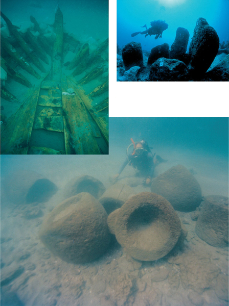
In 1998 the Israel Antiquities Authority, the University of Haifa, and the Aqua Dora diving club excavated the wreck of a small Ottoman trader (the DW2 wreck), the radiocarbon dating of which places it in the seventeenth–nineteenth centuries CE. More than two-thirds of its 15.5-m-long hull survived, including the mast step. Finds included mat baskets, ropes, textiles, oil lamps, and decorated pottery pipes. A few kurkar ashlars and a Roman marble capital were also recovered from the lower floor of the ship. The kurkar stones indicate that the ship carried building stones that were quarried along the Carmel coast. The marble capital may have been used as paying ballast, which is to say, merchandise that also functions as ballast. Roughly 10–15 m west of the Ottoman wreck, another nearly complete hull of an early modern vessel (wreck C, Dor 2002/2) was exposed. The wreck was excavated by the University of Haifa, the Nautical Archaeology Society of England (NAS), and Aqua Dora. It contained numerous ashlars and wooden barrels. During 2002–2003, the wooden hull of a Byzantine wreck (Dor 2001/1) loaded with 80 kurkar ashlars placed on mats was excavated by Y. Kahanov on behalf of the University of Haifa, NAS, and Aqua Dora. The ship was dated to the end of the fifth or the beginning of the sixth century CE. It is the first known vessel in the Mediterranean built skeleton first. Another wreck (Tantura F, Dor 2004), dated to the eighth century CE, was excavated by S. Wachsmann and K. Raveh on behalf of the Israel Antiquities Authority. The excavation was renewed by Y. Kahanov and C. Brandon in 2004. A few planking timbers from a Byzantine wreck (DW4) covered by a pile of ballast stones were excavated by S. Kingsley in 1999/2000. Recovered in the southern entrance to the Tantura Lagoon was a Byzantine assemblage including fishing gear—a multi-point spear and an iron fire basket for attracting fish by light, bronze fishing hooks, and a sounding lead; a counterweight of a steelyard in the shape of a female bust; a hoard of bronze coins; and six iron ingots.
The archaeological evidence collected by the various underwater investigators at Dor to date (Association for Underwater Exploration, University of Haifa, Israel Antiquities Authority, Dor Museum, Conrad Center, and Aqua Dora) indicates that extensive marine activities took place at Dor’s southern anchorage, beginning in the Middle Bronze Age and continuing to modern times. Some of the ships were probably wrecked while anchoring in the lagoon, as it provided little shelter during storms. The recently discovered archaeological evidence reveals that the lagoon served as a transport terminal for building materials for some 1,500 years. Much of the materials came from the local kurkar quarries, although the expertise acquired from quarrying, handling, and shipping these building materials was applied to non-local materials as well, such as limestone and ceramic roof tiles, also found in the waters of the lagoon.

Dor Main Bay Deep-Water Anchorage. The main bay at Dor is c. 3–4 m deep, its bottom mostly sandy, with a rocky barrier (2.5 m deep) at its western entrance. It has been claimed that during the Bronze Age the main bay was part of the southern lagoon. Stone anchors, scattered cargos, and ship fittings found in the bay indicate that it was used as an anchorage from the Late Bronze Age onward. Adjacent and parallel to the southern slope of the tell is a structure built of headers, claimed to be a Bronze Age quay. This structure is difficult to approach by sea due to shallow water, and it remains possible that it was a foundation for a structure located on the coastline. On the southern shore of the main bay, a few rock-cut mooring holes were discovered, indicating that sea craft were moored there.
Neveh Yam Deep-Water Anchorage. About 4 km south of the ‘Atlit peninsula, a series of partly submerged kurkar ridges and a headland create a basin that could provide some shelter from northwesterly and northerly winds. Underwater surveys and salvage excavations carried out by the University of Haifa and the Israel Antiquities Authority exposed a submerged Pottery Neolithic settlement (Neveh Yam, see above), anchors, and assemblages associated with shipwrecks. An assemblage including 15 stone anchors of the Byblos type was attributed to the Middle Bronze Age. A large Late Bronze Age cargo consisted of 83 loaf-shaped copper ingots, as well as a series of hematite weights in the shape of wheat grains, a socketed bronze adze with remains of a wooden handle, a bronze spearhead, and several one-holed stone anchors. Another cargo attributed to the Hellenistic period included several Ptolemaic bronze coins, cylindrical lead bands bearing incised Greek inscriptions, two bell-shaped sounding leads, pyramidal lead weights, round lead boxes with lids, and a bronze figurine of a satyr. Dozens of pottery hand grenades (“Greek fire”) decorated with a scale design, dating to the twelfth–thirteenth centuries CE, were collected in the anchorage area.

‘Atlit Southern Bay Deep-Water Anchorage. An assemblage of objects dating to the Middle Bronze Age was discovered in 1995 by the Israel Antiquities Authority in the southern bay of ‘Atlit. Finds included storage jars, one intact with handles below the shoulder; two stone anchors of the Byblos type; and several one-holed stone anchors. The scarcity of finds suggests that marine activity in the southern bay was more limited than in the northern bay, perhaps because it was more exposed to southwesterly storms.

‘Atlit Northern Bay Deep-Water Anchorage. The remains of fishing equipment and many cargos of wrecked ships were found throughout the northern bay of ‘Atlit. The earliest evidence for open-sea navigation along Israel’s coast was found north of the Crusader fortress of ‘Atlit, c. 600 m offshore and at a depth of 11.5 m. It consists of a complete pottery vessel, which was recovered by the Israel Antiquities Authority in 2001. The jar has an ovoid body with a narrow flat base, a short neck, a rounded everted rim, and a narrow mouth. Three unpierced vestigial knobs were positioned around the shoulder. Petrographic analysis revealed that the jar originated in the Nile region, and it contained shells of freshwater mollusks identified as Nilotic Aspatharia rubens and dated by 14C to the fourth millennium BCE. Comparable ceramic vessels from Lower Egypt (Ma‘adi) and the radiocarbon date of the mollusks place the jar in the Early Bronze Age IA (3400–3000 BCE). It must have arrived to the ‘Atlit region on a seagoing vessel, thus comprising the oldest direct evidence for maritime trade connections between Egypt and the northern coast of Canaan, and suggesting that the northern bay of ‘Atlit served as an anchorage site for sea vessels as early as the Early Bronze Age IA.

Stone anchors of various types were recovered in the northern bay anchorage, including two Byblos-type anchors dated to the Middle Bronze Age, several concentrations of one-holed stone anchors, probably dating to the Late Bronze Age, and 20 three-holed anchors attributed to the Iron Age and Persian and medieval periods. A few assemblages from the Persian period included broken stone jars with basket handles and lead cores of wooden anchors. In addition, bronze furniture parts, horse bridles, duck-shaped weights, and lioness-shaped jar handles were recovered. Three assemblages containing bronze and silver Ptolemaic coins, various bronze objects, and a lead missile bearing a decorative lizard are attributed to the Hellenistic period. A few Greek-inscribed lead balance weights and a relief of a ship’s prow were also recovered. One of the Hellenistic assemblages may have belonged to a vessel that carried a bronze battering ram. A hoard of Byzantine bronze objects cemented together in a concretion contained a bronze socketed standard decorated with a trellis of vine tendrils and bunches of grapes, an engraved seven-branched menorah, a ram’s horn (shofar), and a palm branch (lulav), and bearing an inscription mentioning the Talmudic city of Shiqmona. Also within this hoard was a bronze figurine of a woman carrying flowers, and four wooden spikes used for splicing ropes. A Mameluke-Ottoman shipwreck from the sixteenth century included four bronze swivel-bow cannons and a bronze bombard (weight 2,200 kg, length 3.25 m), 14 stone cannon balls (diameter 30 cm), and 20 bronze helmets. A two-armed admiralty anchor with traces of its wooden stock and two large grapnel anchors were also found.

Rows of wooden poles imbedded upright in the sea floor were found in several concentrations near the coastline, east of the ancient harbor. The poles were dated by 14C to the Crusader period. A cluster of ribbed stone columns (c. 2 m high) with a square base and a perforation in the upper part were discovered east of the harbor at the foot of the north end of the ruined Crusader city wall. Chains or wooden rods may have been threaded through the perforations. The columns together with the wooden poles may have formed part of a barrier built in shallow water to prevent enemy forces from approaching the fortress walls from the northeast. Alternatively, the stone columns and wooden poles may represent the remains of a jetty, quay, or some other mooring installation.
HAULING AND MOORING FACILITIES. In the southeastern corner of Achzib Bay, two round bollards were cut into the kurkar rock about 3 m from the coastline. Six similar bollards were cut into the coastal limestone of a small bay south of Shiqmona. These bollards were apparently used for hauling and mooring vessels in order to unload heavy cargos such as stone architectural elements by dropping them into the sea close to the coast and dragging them ashore.
CARGOS OF BUILDING STONES. Heavy objects such as architectural elements and building stones quarried near the shore were transported and traded by sea whenever possible. Underwater surveys along the coast of Israel have revealed numerous concentrations of such materials, classifiable into three main categories: (1) Imported exotic materials such as finished and semi-finished marble and granite columns, capitals, slabs, and other architectural elements, intended for prestige structures. Such assemblages have been discovered at the port of Acco, the Caesarea southern anchorage (a cargo of semi-finished marble slabs, another of column bases, and another of column capitals), the Apollonia-Arsuf and Yavneh-Yam anchorages, and the Ashkelon open-sea anchorage. The semi-finished exotic stones were probably carried as paying ballast intended for further processing by local workshops. (2) Kurkar building stones hewn from the coastal ridges. Six such cargos were recovered off the Carmel coast (three cargos off the southern beaches of Haifa, one off Kefar Galim, one off
MEDITERRANEAN SHIPWRECKS AND CARGOS UNASSOCIATED WITH ANCHORAGES
MIDDLE BRONZE AGE ASSEMBLAGES. Concentrations of one-holed, Byblos-type stone anchors originating from shipwrecks were located off the Kefar Galim coast and off the southern coast of Haifa, in addition to those above-mentioned assemblages from off the Neveh Yam coast and in the ‘Atlit southern and northern bays. The anchors from Kafr Samir bear reliefs of sea vessels and Cypro-Minoan inscriptions.
LATE BRONZE AGE ASSEMBLAGES. To the south of Haifa, 100–150 m off the coast of Kafr Samir, three Late Bronze Age shipwreck assemblages unassociated with anchorages were investigated by the Israel Antiquities Authority and the University of Haifa. The northernmost assemblage consisted of fragments of ox-hide ingots, plano-convex lead ingots, one-holed stone anchors, and a bronze figurine of the god Ba‘al. Another Late Bronze Age assemblage found c. 500 m to the south included a sickle sword, large (25–30 kg) plano-convex tin ingots, small (2–4 kg) perforated lead ingots bearing Cypro-Minoan signs, and a group of five one-holed stone anchors, one of which is engraved with a scarab design. The southernmost cargo was discovered another c. 600 m to the south and included 2 whole ox-hide ingots; 10 small (3–5 kg) and 7 large (20–30 kg) tin ingots, some perforated and/or bearing Cypro-Minoan inscriptions; socketed bronze axes; and 15 one-holed stone anchors weighing 120–200 kg. A fourth Late Bronze Age cargo was discovered half a kilometer south of Kefar Galim by a team of divers from the University of Haifa. Among the finds were fragments of lead ingots, a broken ox-hide ingot, bronze objects (including a horse’s bridle), and two one-holed stone anchors. South of the Mikhmoret anchorage, a Late Bronze Age shipwreck contained three one-holed stone anchors, a sickle sword, and a bronze dagger.
In addition to these assemblages, dozens of clusters of Late Bronze Age one-holed anchors have been recorded off the northern Carmel coast and one off the Beit Yannai coast, most of them found in unsheltered areas close to the coastline at depths of 2.5–4 m. The distribution of these anchors on the seabed is typical of the site formation of wrecked seagoing vessels. These finds attest to intensive maritime activity in the region during this period and a lack of shelters for proper safe anchorage during severe storms.

HELLENISTIC ASSEMBLAGES. Off the Megadim coast, some 6 km south of Haifa, the cargo of a Hellenistic shipwreck was discovered in 1968 by divers from the Association for Underwater Exploration. The site was excavated in 1980 by a team from the Israel Antiquities Authority under the direction of E. Galili, S. Wachsmann, and K. Raveh. The vessel carried a cargo that included bronze and silver coins of the Ptolemaic and Seleucid dynasties (second century BCE), bronze nails and fittings, broken bronze anthropomorphic and zoomorphic figurines, and life-size anthropomorphic statuary fragments. In addition, the cargo contained a wine amphora in secondary use that held dozens of kilograms of metal objects, such as decorated bracelets, gold-plated diadems, arrowheads, metal smith’s tools, nails, architectural clamps, bucket handles of small vessels, tacks for fixing lead sheathing, gilded decorated tucks, a gilded stem and leaves of a wreath, copper ingots, and other metal fittings and jewelry. The character of the finds, the tools, and the unfinished jewelry items suggest that one of the vessel’s passengers was a jeweler, a metal smith with a portable workshop, or a scrap-metal dealer. The pieces of large bronze statuary were probably intended for recycling.
Two additional Hellenistic shipwreck assemblages were recovered off the Kafr Samir coast. The finds included a hoard of thousands of Ptolemaic silver coins dated to the second century BCE, lead fastenings of stone anchors, sounding leads, bronze fittings shaped like lion heads, bronze nails, and sections of lead sheathing from the vessel’s hull.
ROMAN ASSEMBLAGES. Four Roman shipwrecks from the second century CE were intermittently explored in the Kafr Samir region off the municipal beach south of Haifa (1965–2005). Their cargos included anthropomorphic bronze figurines, bracelets, necklaces, pendants with phallic symbols, balance scale bars, silver and bronze coins, lead stoves used onboard, lead fastenings of wooden anchors, iron anchors, bronze nails and domestic objects, craftsman’s tools, and ship fittings made of copper, bronze, iron, and lead. Three additional Roman shipwrecks were discovered off the Carmel coast between Haifa and ‘Atlit, and two assemblages off the Ashkelon coast in the south of Israel. A cargo of six biconic basalt millstones was recovered 600 m south of the Apollonia-Arsuf anchorage at a depth of 3 m; the millstone sets were unused, probably lost on the way to customers. Bronze nails scattered around the millstones attest to the wreckage.
LATE ROMAN ASSEMBLAGES. Three Late Roman shipwrecks were intermittently explored off the Carmel coast between Haifa and ‘Atlit (1970–2005). The cargos contained thousands of bronze coins of Constantine the Great, iron anchors, ship fittings, and various metal artifacts. Another two Late Roman assemblages were recorded off the Ashkelon coast.
BYZANTINE ASSEMBLAGES. The cargos of six Byzantine ships were intermittently explored from the seabed some 100–150 m off the northern Carmel coast between Haifa and Megadim (1970–2005). The artifacts, scattered at depths of 2.5–4 m, included mainly iron anchors, bronze coins, bronze and lead artifacts, and bronze nails. Two other Byzantine assemblages of similar nature were recorded off the Ashkelon coast.
MAMELUKE ASSEMBLAGE. A Mameluke shipwreck from the beginning of the fifteenth century CE was intermittently recovered off the Megadim coast (1982–2000). Its cargo included a huge hoard of bronze coins held in wicker baskets (totaling 350 kg); hundreds of bronze artifacts originating from a mosque, including decorated lighting devices such as candlesticks, lamp stands, bowls for collecting wax, and fittings for suspension; as well as mortars and pestles, door decorations, ornamental wooden box fittings, bowls, domestic utensils, five hoards of iron fittings and nails (weighing c. 400 kg each), and scanty remains of the ship’s wooden hull. Most of the coins were minted by the Mameluke sultans Faraj and Barquq in eastern Anatolia and northern Syria. The ship was most probably wrecked while sailing from the northern Levantine coast to Alexandria with a metal cargo.
MEDITERRANEAN COASTAL ROCK-CUT INSTALLATIONS AND QUARRIES
Rock-cut installations intended for salt production were located during surveys by the Israel Antiquities Authority along the Carmel coast. The topography of the Carmel coast between ‘Atlit and Dor is suitable for producing salt from sea water. The elongated shallow areas (troughs) along the shore situated between the kurkar ridges, which are almost at sea level, contain impermeable clay sediments that can hold water and are thus suitable for sea-water evaporation pans. The evaporation pans (floors) were made of perishable materials and did not survive, but the rock-cut installations did. Sea water was obtained by several types of installations. Located between ‘Atlit and Neveh Yam are four installations consisting of sloping rock-cut surfaces used to capture sea water through wave energy, and rock-cut channels to convey the water eastward to the evaporation ponds in the troughs. South of Neveh Yam and in the ha-Bonim nature reserve, 11 additional rock-cut installations were recorded. They were comprised of sea-water wells, channels, and rock-cut reservoirs located some 3–10 m inland. From the reservoirs, the water was elevated by windmills or water-wheels and conveyed eastward by gravity to the evaporation pans via rock-cut, wooden, or clay aqueducts. Presently it is hard to date such rock-cut structures, although some Hellenistic, Roman, and Byzantine sherds were found in association with them. Similar pre-modern installations for producing sea-salt are known from Spain, Sardinia, Sicily, Malta, and northern Lebanon.

There is also evidence of millstone quarries. Two concentrations of round circles cut in the local beach rock were discovered on the coastal rocks opposite the northern suburb of Acco. Their diameter varies between 1 and 1.4 m and their depth is c. 20 cm. The circles are concentrated in the inter-tidal zone, at an elevation ranging from 0.2 m below sea level to 0.5 m above sea level. All together, 48 such circles were discovered; in 13 cases broken stones still remain in situ, attached to the bedrock. The rock is a hard beach rock comprised of cemented shells, perhaps an inexpensive substitute for high-quality basalt, the usual material for millstone production. The location of the quarry was chosen due to the availability of suitable hard beach rock near the shore, and the presence of a deep underwater canyon—an ancient inundated river course—that enabled the approach of watercraft.

These rock-cut installations on the coast of Israel, directly associated with the sea, provide valuable information about sea level changes and coastline displacement. The available data has revealed that no major sea-land changes have occurred in the region during the last 2,000 years.
THE SEA OF GALILEE
Since 1985, there have been major fluctuations in the water level of the Sea of Galilee, and many archaeological sites, including ancient anchorages, shipwreck cargos, submerged structures, coastal installations, and a wooden boat have been discovered in the lake.
ANCIENT HARBORS AND ANCHORAGES. The Sea of Galilee is known for its sudden storms, which are caused by moderate easterly or westerly winds. A few natural anchorage sites are located on the northern shores of the lake. About 300 m northeast of
However, in order to maintain maritime activity in the lake, sufficient harbors were needed. Since the 1970s, with the lake’s receding water level, stone-built harbors have been discovered around its shores at Kefar Aqavia, Kursi, ‘En Gofra, Hippos, Duerban, Gadara, Beth
SHIPWRECK CARGOS. A Late Bronze Age assemblage containing bronze spearheads and a decorated spear handle was recovered in the natural anchorage of Hale. Some of the artifacts had melted, suggesting that the vessel had been attacked and burnt. Concentrations of artifacts on the seabed originating from shipwrecks were discovered close to the ancient harbors of Magdala, Hippos, and ‘En Gofra, at 214 to 216 m below sea level. The finds include Roman, Byzantine, and Early and Late Islamic cooking vessels, storage jars, amphorae, oil lamps, and glass and bronze artifacts. The sailing ships apparently anchored some distance offshore and were unloaded by small boats that entered the harbors.
SUBMERGED STONE STRUCTURES. During an underwater survey carried out by the Israel Antiquities Authority south of Magdala, a concentration of basalt ashlars, capitals, and column drums was discovered some 30 m offshore, scattered at the foot of a huge isolated rock called the Rock of Ants, which is usually partially submerged (when the water level is 209 to 211 m below sea level), forming a small island. During the survey, round depressions matching the diameter of the fallen columns were discerned in the rock. It seems that these architectural elements originated in a structure that once stood on the upper part of the rock, perhaps a small shrine, a lighthouse, or a pergola.
On the southern and eastern shores of the lake, many round tumuli and stone circles built of undressed stones, 1–4 m in diameter, were found at elevations of 212 to 215 m below sea level. The structures were sometimes arranged at equal intervals parallel to the coastline. The function and date of these structures are still unclear. The larger ones (on the southern coast) may have served as fish nurseries; the smaller ones, arranged in a straight line (at ‘En Gofra), could have supported the wooden poles of a fishing weir.

On the dry, temporarily exposed seabed near Kursi, a square structure built of ashlars and cemented with white plaster was recorded in October 2000. Though the function of the structure is unclear, the plaster indicates that it was built on dry land. The elevation of the structure, at 213.75 m below sea level, indicates that sea level at the time of its construction was lower than 214 m below sea level.
GRINDING-STONE ASSEMBLAGES. East of Beth
THE DEAD SEA
As a result of droughts and over-exploitation, the water level of the Dead Sea has dropped considerably—by 10–15 m—in the last 20 years. Wide portions of its bottom are currently exposed and two ship assemblages have been discovered. Near En-Gedi four one-holed stone anchors (weighing c. 110 to 134 kg) and ropes made of palm fibers were found. Radiocarbon tests on the ropes have provided dates from the second–third centuries BCE. A shipwreck assemblage found off Khirbet Mazin south of ‘Ein Feshkha included several thousand bronze coins of the Hasmonean dynasty, almost all belonging to the reign of Alexander Jannaeus, and a few fragments of life-size bronze statues. This hoard was associated with a nearby structure suggested to be a royal dry dock (Khirbet Mazin), a claim that awaits further investigation. Recently, two wooden anchors with remnants of ropes were discovered near En-Gedi by G. Hadas. One is a composed two-armed wooden anchor with traces of lead stock, a lead assembly piece, iron bills, and bronze nails. The second anchor, dating to the Iron Age or Persian period, is a one-armed wooden killick with stone stock and ropes made of palm fibers.
At Rujm
EHUD GALILI, BARUCH ROSEN
Jisr ez-Zarqa
Magdala (Migdal Nunya)
Neveh Yam
Shavei Ẓion
Color Plates
The southern Levantine coasts have been a cradle for maritime civilizations since the Pre-Pottery Neolithic period. These coasts are the closest marine environments to the core areas in which plants and animals were first domesticated. The first agro-pastoral-marine subsistence systems (so-called “Mediterranean fishing villages”) emerged on these coasts during the ninth millennium
SUBMERGED PREHISTORIC SETTLEMENTS
Several Neolithic settlements dating from the ninth to the seventh millennia