
Miqne, Tel (Ekron)
EXCAVATIONS
The Tel Miqne excavations, begun in 1981, were concluded in 1996 after 14 seasons of fieldwork. The project was sponsored by the W. F. Albright Institute of Archaeological Research and the Institute of Archaeology of the Hebrew University of Jerusalem, and directed by T. Dothan and S. Gitin. It was affiliated with the American Schools of Oriental Research and the Israel Exploration Society, and supported by a consortium of 22 American, Canadian, and Israeli institutions.
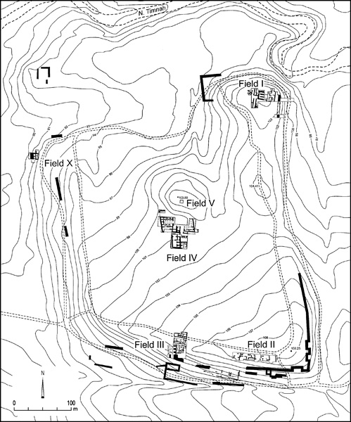
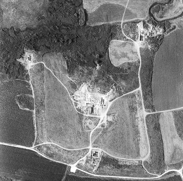
During the six most recent seasons of excavation (1992–1996), fieldwork continued in the upper (field I) and lower city (fields II, III, IV, and X). On the summit of the northeast acropolis (field I), the occupation levels of the Late Bronze Age II through the Iron Age II (strata VIII–I) were further defined. In 1995–1996, in a newly opened sub-field immediately north of and parallel to the original sondage begun in 1981, further evidence was uncovered of the end of the Late Bronze Age II (stratum VIII) and of the earliest elements of the first Philistine city (strata VII–VI), including the construction phase of its city wall. In the lower city, excavations continued in 1992–1996 at the center of the southern ridge (field III), north of the Iron Age I city wall, in which four phases of the Iron Age I city (strata VII–IV) and a Middle Bronze Age II rampart (stratum XI) were uncovered. In the center of the lower city, in the elite zone (field IV lower), excavations continued in 1992–1995, producing the most extensive sequence of Iron Age I occupation (strata VII–IV), as well as further evidence of Iron Age IIC (strata IC–B). In 1992, east of the Iron Age II city gate (field III), a large extension of the late Iron Age II (stratum IB) olive-oil industrial zone (field II) was defined. In 1995–1996, two new fields were opened in the lower city. In the elite zone (field IV upper), a new Iron Age IIC late Philistine monumental building complex (stratum IB) was uncovered; it extended to the slope of the northwest acropolis (field V), where there were also Roman and Islamic remains. In the northwestern corner of the mound (field X), a section of the Middle Bronze Age II rampart (stratum XI) was found immediately below the Iron Age I city wall. Several buildings, including a cultic area from the earliest Philistine city (strata VII–V), were constructed against this wall.
EXCAVATION RESULTS
The last six seasons of excavations confirmed the occupation profile of the mound established in the previous excavations. With the abandonment of the 40-a. lower city at the end of Middle Bronze Age II, the Late Bronze Age Canaanite occupation of the site was confined to the 10-a. northeast acropolis, the upper city. Immediately following its destruction in the initial phase of Iron Age I, the entire mound became part of a large fortified Philistine city of 50 a. By the beginning of Iron Age II, however, the population had again receded to the northeast acropolis, and the lower city remained abandoned until the beginning of the seventh century BCE, when the last large Philistine city was built. This city occupied the entire mound and was refortified and expanded northward, encompassing about 85 a. It was destroyed at the end of the century. The site was never again occupied on the same scale.
| Stratum |
Period | Date BCE |
|---|---|---|
| IA | Iron IIC | 7th/6th century |
| IB | Iron IIC | 4th quarter of 7th century |
| IC | Iron IIC | 1st–3rd quarter of 7th century |
| IIA | Iron IIB | 2nd half of 8th century |
| IIB | Iron IIB | 1st half of 8th century |
| III | Iron IIA | 2nd quarter of 10th–9th century |
| IVB–A | Iron IB/IIA | 2nd half of 11th–1st quarter of 10th century |
| VC–A | Iron IB | 1st half of 11th century |
| VIB–A | Iron IB | 4th quarter of 12th/11th century |
| VIIB–A | Iron IA | 2nd–3rd quarter of 12th century |
| VIIIB–A | LB IIB | 13th century–1st quarter of 12th century |
| IX | LB IIA | 14th century |
| X | LB I | 2nd half of 16th–15th century |
| XI | MB IB | 17th–1st half of 16th century |
THE MIDDLE BRONZE AGE. The Middle Bronze Age (stratum XI) was further attested in the lower city by segments of a large mud-brick rampart, part of the Middle Bronze Age II fortifications, which was erected on the periphery of the mound and gave the site its shape. In field III, along the southern ridge, the width of the rampart was at least 18 m immediately below the earliest Iron Age I occupation levels (strata VII–VIB). In field X, in the northwest corner of the mound, the rampart served as the foundation for the Iron Age I city wall (stratum VII). In both cases, the latest pottery from the rampart dated to the Middle Bronze Age II.
THE LATE BRONZE AGE. On the summit of the northeast acropolis (field I) the earliest Late Bronze Age II remains consisted of a series of ash-covered plastered floors and disparate architectural features with typical Late Bronze Age II coarse wares and imported pottery from the Aegean and Cyprus (stratum VIIIB). Immediately above was a large building complex of seven rooms, which served as a food storage area with two large plastered silos and large concentrations of carbonized grains and numerous storage jars, one of which was filled with perforated figs. The massive destruction of this final Late Bronze Age phase (stratum VIIIA) is dated by its pottery, which included Late Bronze Age IIB coarse wares and imports, such as Mycenean IIIB stirrup jars, Cypriot milk bowls, base ring II bilbils and bowls, and white-shaved juglets.
THE IRON AGE I. The Fortifications in Field I. The stratigraphic sequence in the sub-field on the slope of the northeast acropolis and north of the original sondage confirmed that the first Philistine city and its city wall (stratum VIIB) were built immediately following the destruction of the Late Bronze Age city (stratum VIIIA). The secure chain of evidence includes rows of mud bricks that sealed the city wall’s foundation trench, which, like the final Late Bronze Age occupation phase, was covered by thick orange layers of crushed burnt mud bricks that served as the base for the construction of the earliest Iron Age occupation. The orange layers were derived from the destroyed and heavily burnt mud-brick buildings from the final Late Bronze Age occupation on the summit of the acropolis. The latest pottery from the foundation trench, from the rows of mud bricks that sealed it and from the orange layers, is dated to the Late Bronze Age IIB. The orange layers, however, also contained a few sherds of locally made Mycenean IIIC:1 pottery, the hallmark of the Sea Peoples/Philistines appearance at the beginning of the Iron Age I. This pottery, which includes monochrome decorated round-sided bowls, bell-shaped bowls and kraters, carinated bowls with strap handles, kylikes, jugs, strainer spouted jugs, feeding bottles, stirrup jars, pyxides, small undecorated carinated bowls, kalathoi, and coarse ware cooking jugs, all with strong Aegean affinities and close parallels in Cyprus, appears in ever larger numbers through the earliest cultural horizon of the Iron Age, and represents the main diagnostic pottery type of the first phase of the Philistine city (strata VIIB–A). A date near the end of the first quarter of the twelfth century for the Late Bronze Age IIB destruction level and the founding of the Philistine city (stratum VIIB) is based on the low Egyptian chronology, as well as the correlation of the earliest appearance of Mycenean IIIC:1 pottery on the Greek mainland with its appearance and that of the Sea Peoples in the Mediterranean basin.
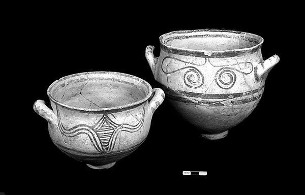
The excavations in the new sub-field confirmed the stratigraphy and enlarged the building plan of the previously excavated sequence in the sondage (strata VII–V). The enlarged plan indicates that this area of the first Philistine city (stratum VII) was laid out according to a grid, in line with the angle of the city wall, and was organized into industrial and domestic areas. The primary features of its earliest main occupation phase (stratum VIIA) were pottery kilns and a large assemblage of Mycenean IIIC:1 pottery. In the next phase (stratum VI), kilns and Mycenean IIIC:1 pottery continued, but in diminishing numbers. Philistine bichrome ware made its appearance and became the primary decorated pottery of this and the following phase (stratum V). The absence of kilns and the numerous tabuns in stratum V indicate that this area was used mostly for domestic purposes. Of special interest are the intramural infant burials, five of which were uncovered in stratum VI. These are similar to two infant burials found on the summit of the northeast acropolis (field I in strata VI and V) and three in the lower city (field IV in strata VII and VI, and field III in stratum VI). The new sub-field also contained a cultic installation—possibly for purification rites—which consisted of a room with a bench, a freestanding square hearth in the center, and a limestone bathtub adjacent to a wall (stratum VII). A bathtub in a cultic setting was also found in stratum VIA in building 353 in the elite zone of the lower city (field IV lower). Similar bathtubs, some made of limestone and others of terracotta, are known from Ashdod, Ashkelon, Enkomi, and Mycenae, and demonstrate an Aegean cultic affinity.
On the summit of the northeast acropolis, the earliest Philistine occupation phase (stratum VII) may have continued the storage facility tradition of the previous Late Bronze Age. Twelve pits of various sizes were dug directly into the Late Bronze Age destruction level, and the debris they produced was most likely the source of the crushed burnt mud-brick material used as the construction base for the Iron Age I (stratum VIIB) buildings in the adjacent sondage and its northern slope extension. Some of the deep pits, although unlined, were probably also used for storage and waste disposal. They must have been exposed during stratum VII, as the latest ceramic evidence was Philistine bichrome pottery, which first appeared in stratum VIB. Ten pits were also dug in stratum VI, some of them lined with plaster and clay. This stratum, like the other Iron Age I strata (V–IV), was characterized by a strip of open area with small round hearths lined with burnt pebbles and covered with ash—16 in stratum VI, 10 in stratum V, and 4 in stratum IV. Similar Iron Age I hearths also occur in fields III and IV. Stratum IV, in part an Iron Age I/II transitional phase, was characterized by red slip and burnished pottery, and a new open area or street that continued to be one of the main features of the architectural plan of the summit of the acropolis throughout Iron Age II (strata III–I).
Field X. The Iron Age I mud-brick city wall (stratum VII), in the northwest corner of the lower city, was 6 m wide and built over the shaved-down Middle Bronze Age II mud-brick rampart of stratum XI. The building complex, constructed against the city wall, contained two rows of rooms, the eastern of which had a room with plastered walls and a plastered bamah (stratum VII). This building also contained an assemblage of Mycenean IIIC:1 pottery, including a terracotta hedgehog—a libation vessel known from the Aegean, Cyprus, and cult centers throughout the Levant. In the next phase, the bamah was replaced by a plastered platform. This cult room parallels the shrine (strata VI–V) on the slope of the northeast acropolis, also on the periphery of the city.
Field III. At the center of the southern ridge of the mound, the city of stratum VII was constructed over the shaved-down Middle Bronze Age II mud-brick rampart, and extended northward from the Iron Age I mud-brick city wall. This stratum was evidenced by disparate architectural elements and an assemblage of Mycenean IIIC:1 pottery. In stratum VI, the domestic building complex 404 contained a large number of tabuns—14 small, round, burnt pebbled-lined hearths—similar to the 30 found on the summit of the acropolis in field I and the two in the elite area of field IV. Philistine bichrome pottery made its first appearance in this stratum. Finds of special interest include an ivory hoard with a duck head and a plaque decorated with two swimming Egyptian women; a zoomorphic terracotta vessel in the shape of a bull; a conical stamp seal depicting two prancing gazelles; four animal skulls, two with twisted horns, reminiscent of the bull skull shrine at Enkomi; and an infant jar burial similar to those found in fields I and IV.
In stratum V, the public building complex 403 had a monumental entrance formed by a large flagstone pavement with matched wall insets in front of a mushroom-shaped stone pillar base. This plan was similar to the monumental entrance of the megaron building 350 in field IV. Philistine bichrome pottery continued to appear in stratum V, together with the earliest examples of red slip and hand-burnished pottery, whose floruit was in stratum IVA. Stratum IV consisted of two building complexes, 401 and 402; the latter, in stratum IVA, was equipped with an extended platform that supported a large number of built-up plastered installations. Cultic finds included 40 astragali, and an incised scapula similar to those found in field I.
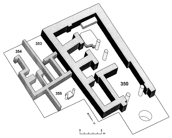
The Elite Zone in the Lower City (Field IV). Located close to the center of the mound, the earliest Iron Age I phase of the elite zone (stratum VII) was built directly over the remains of the end of the Middle Bronze Age (stratum XI). Strata VIIB and VIIA were represented by a number of architectural units including “silo room” 352 (stratum VIIA), which had previously been designated a “hearth sanctuary” in building 351 of stratum VIB. Strata VIIB–VIIA also contained rectangular raised hearths, the tops of which were paved with flat-lying sherds, an infant jar burial, and an assemblage of Mycenean IIIC:1 pottery. Of special interest is a zoomorphic vessel of a bull in a “flying gallop” position (stratum VIIB), which, like the hearths and Mycenean IIIC:1 pottery, is characteristic of the Aegean tradition. The strata VIB and VIA building complex 351–360 was further exposed and found to contain 23 separate units, of which courtyard building 351 was the largest. One of the units, 357, contained a sherd-paved rectangular hearth, a bench, and a bird askos—a small libation vessel well known in the Mycenean pottery repertoire. Building 354 had two small pebble-lined hearths similar to those on the summit of the acropolis in fields I and III. Four of the buildings also housed six round pillar bases, an architectural feature that continued into the last Iron Age II phase. The courtyard of building 353 contained a monolith next to a limestone bathtub, which was somewhat larger than the bathtub from the field I sub-field. The room north of the courtyard was plastered wall to wall and had three plastered basins framed with large standing sherds, and mud bricks. It also contained the richest pottery assemblage in the building complex, including pyxides and flasks, one of which was tubular with a modeled decoration of a human face, possibly representing a goddess. To the north in building 355 an infant jar burial was found. Mycenean IIIC:1 pottery appeared in diminishing numbers and Philistine bichrome pottery made its first appearance in stratum VIB. Strata V and IV consisted of a double complex of buildings. On the west side, the monumental megaron-type building 350 replaced the eight architectural units of stratum VI. In front of the large entrance hall of building 350, which was flanked on either side with buttresses, were round pillar bases. An infant jar burial was found to the east of the entrance. The entranceway was similar to the one in a stratum V building in field III. On the east side, courtyard buildings 353–355 continued with some internal architectural modifications. Philistine bichrome pottery made up the main decorated ceramic assemblage of stratum V, while red slip and hand-burnished pottery, first appearing in stratum V, became the most prominent in the ceramic assemblage of stratum IV.
THE IRON AGE IIA–B. Evidence of the Iron Age IIA–B was found only in the upper city, in the northeast acropolis (field I). Following the end of the Iron Age I occupation (stratum IV), a series of monumental stone walls was constructed running east–west up and across the top of the acropolis, and forming part of a huge system of terraces and platforms on which the Iron Age II city was built. Due to heavy erosion on the acropolis slopes, the only stratified sequence of Iron Age II occupation levels was found on the summit. At the very bottom of the east slope, however, remains were found of the strata III–II mud-brick city wall, which was rebuilt in stratum I. Near the bottom of the west slope a cellar room was excavated, into which had collapsed the debris of a destroyed upper room that was filled with whole and restorable pottery vessels.
The Upper City. The defining feature of strata III–II was a series of three north–south streets, delimited on either side by walls that formed the outside façade of rooms/shops opening onto the street. The earliest street (stratum III) was built directly over a stratum IV street or open area. It in turn was sealed by the second street (stratum IIB), which had an extensive drainage system composed of a stone-lined central drain into which seven tributary stone-lined drains flowed from the buildings flanking the street. A secondary east–west tripartite drainage system formed a junction at the north end of the street. In stratum IIA, the third street in the sequence, composed of thick white plaster, sealed the stratum IIB street and drainage systems and represented a completely different method of managing the flow of water, which easily ran down the impermeable surface of the street. Strata III–II yielded a large assemblage of 26 pottery types, the first comprehensive corpus of Iron Age IIA–B vessels from a Philistine site. Among the most prominent Philistine coastal forms are the small bowl with incised rim, the curved ridged rim bowl, the hammer-head rim globular krater with footed base, and the ridged-rim hole-mouth jar. Judean forms include the slightly carinated everted rim bowl with red slip and burnish, the late shallow cooking pot, the ovoid storage jar with vertical neck and simple rim, the short cylindrical and squat red-slipped dipper juglet, and the small black burnished juglet. One of the Phoenician forms was the everted flat rim bowl with red slip and burnish. Among the objects of stratum IIA were a lamelekh stamped handle and a cultic lion-bowl with the hand motif.
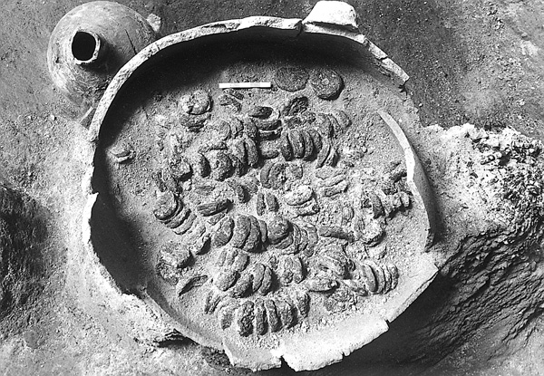
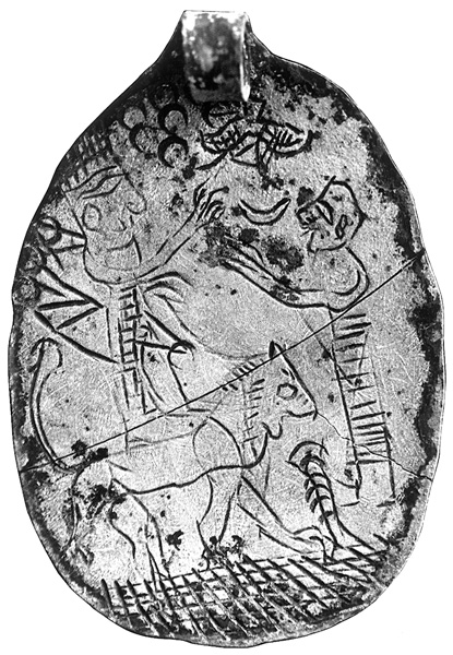
In stratum I, the entire site was again reoccupied. Ekron, as a Neo-Assyrian vassal city-state, achieved the zenith of its growth when it became the largest olive-oil production center thus far uncovered in antiquity. In field I, the main new architectural features included a large formal entrance room with a thickly plastered floor and a central drain composed of three limestone blocks, and a monumental storage magazine with three long rooms. The primary ceramic assemblage was comprised of late seventh-century coastal forms, some of which represent the final typological deve-lopment of pottery types that can be traced back to the beginning of the Iron Age II or earlier. In addition, it contained pottery exclusive to the seventh century, such as the Judean En-Gedi type cooking pot, the East Greek skyphos and aryballos, the flat-based mortarium, and the Phoenician type cyma-shaped storage jar. Among the objects was a hoard of 30 pieces of silver and various types of jewelry. Also found was a silver medallion depicting a Neo-Assyrian cultic scene, with the goddess Ishtar standing on a lion and facing a worshipper with outstretched arms below signs of the Pleiades, a crescent moon, and a winged sun. This was one of six silver hoards found in stratum I; the others were found in the lower city.
The Lower City. As regards the reoccupation of the lower city at the beginning of the seventh century, the excavations uncovered additional evidence of its refortification and massive expansion northwards, and of the existence of its industrial olive-oil and elite zones of occupation. A thorough investigation in the lower city (fields II, III, IV, V, and X) corroborated the fact that between stratum IV, dating to the first quarter of the tenth century (the end of Iron Age I), and strata IC–IB of the seventh century, there was an approximately 270-year gap in occupation. The earlier conclusion, that the Iron Age II city wall extending along the crest of the mound could have been in use only in the seventh century, was also confirmed. In the eighth century, no lower city existed to which it could have belonged. This wall was, therefore, not the one depicted in the relief from 712 BCE in Sargon II’s palace at Khorsabad, in which the Assyrians are shown besieging the city of ’amqar (r)ûna, which is Ekron. The wall depicted in the Sargon II relief could correspond only to the stratum II city wall with the large, impressive mud-brick tower faced with ashlar masonry that was excavated at the bottom of the slope of the northeast acropolis (field I).
New evidence also demonstrated that the reuse in stratum IB buildings of discarded stratum IC components of olive-oil production installations, including crushing basins, pressing vats, and stone weights, was a general phenomenon in the architectural modifications of buildings, and represents the most characteristic aspect of stratum IB construction. As for the end of stratum IB, the heavy layer of destruction that covered most of the seventh-century city, caused by the Neo-Babylonian conquest of Nebuchadnezzer, has been redated from 603 to 604 BCE, based on a reevaluation of the Babylonian Chronicles.
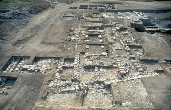
The Town Plan. In field II, the olive-oil industrial zone was further exposed east of the olive-oil factories inside the city-gate area (field III), and immediately behind and parallel to the city wall. Parts of five olive-oil factories with 12 basins, 14 olive-oil presses, and 14 perforated stone weights were identified, bringing the total number to 115 olive-oil production units in stratum IB. Field II also produced a number of late seventh-century storage jars and other vessels, as well as two four-horned altars, an incense stand, an Egyptian faience bowl, and an alabaster juglet. To the south of field II, a large building was connected to the city wall on the west, and was separated from it on the east by an opening, which appears to be another gate leading directly to the industrial zone. This building, which incorporated a line of about 80 m of storerooms/stables, may have served as an administrative facility for the olive-oil industrial production center. Immediately below it on the slope, the line of the wall identified by J. Naveh in 1957 was excavated and shown to be a screen wall protecting the southern side of the industrial zone.
In field III, further evidence of stratum IC was uncovered, including a stone crushing basin, a stone drain, a perforated stone weight, and multi-surface laminations immediately below a stratum IB olive-oil installation room, and built directly over the shaved-down remains of stratum IVA. Nearby, a jewelry hoard of 262 pieces, of which 53 were of silver, was found in a jug buried beneath a strata IC–IB wall.
The Elite Zone. In field IV lower, the later excavations uncovered in stratum IC eight partially preserved rooms of the first phase of three stratum I buildings: 651, 653, and 654. A unique find, a sherd of a Middle Geometric cup with a meander decoration, was uncovered immediately below a stratum IC wall. An isolated example of an eighth-century Greek import, it can be associated with the “scoop phase,” which is defined by the presence of a number of ceramic scoops found in the elite zone between the abandoned stratum IV and the earliest floors of stratum IC. Scoops may have been used in food distribution during the short period at the end of stratum IIA, when the Judean king Hezekiah took control of Ekron.
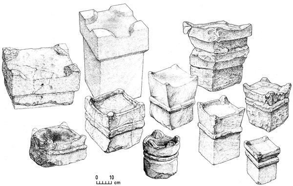
Field IV lower was also expanded northward in order to enlarge the excavated area of the stratum I temple auxiliary complex, buildings 651–655. Three of these, buildings 651, 652, and 653, were oriented towards the main entrance of temple complex 650. The cultic character of the auxiliary complex was exemplified by seven four-horned incense altars and six incense stands, including a cultic corner with two altars and two stands in room e of building 653. Building 654 produced five dedicatory inscriptions and seven single word inscriptions. Three silver currency hoards found in the temple auxiliary complex, two in building 654 and one in building 651, may have been related to transactions connected with the support of the cultic activities of the complex.
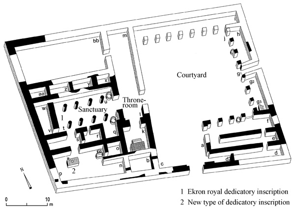
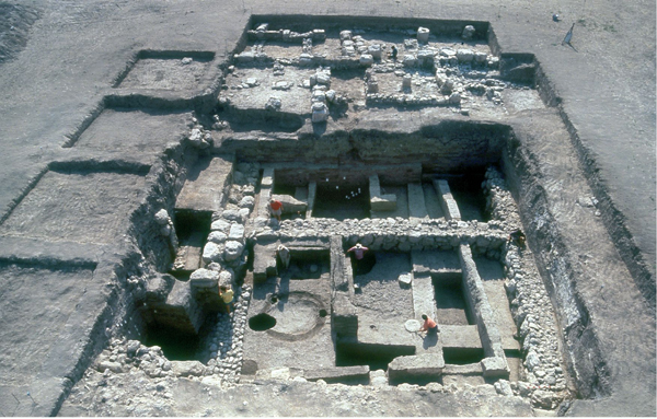
Field IV Upper. The monumental structure, temple complex 650, was located just north of the temple auxiliary complex. Its architectural plan, while unique to the region, is based on the design concept and relationship of the three primary components of Neo-Assyrian royal palaces, residences, and temples. The first component is a large square-shaped open courtyard around which was a portico sub-divided into a series of rooms. The second is a long, narrow rectangular-shaped throne room or reception hall, which bisects the building and has at one end a raised mud-brick platform or throne with steps leading up to it. As in Neo-Assyrian-type monumental buildings, this room served as a buffer between the large courtyard and the third component of a large building on the west side. The latter contained a rectangular-shaped sanctuary with side rooms, a main hall lined with two parallel rows of four round column bases each, and a raised cella at its far end. The plan of the pillared sanctuary reflects a Phoenician design; a similar sanctuary can be found in the Astarte temple at Kition on Cyprus. However, the reuse of the round pillar bases from Ekron’s Iron Age I buildings, as in the pillared room of building 651, demonstrates the continuity of a local architectural tradition. Thus, temple complex 650 with its sanctuary represents a hybrid of different foreign and local architectural traditions.
Foreign influences are also indicated by artifacts found in the sanctuary’s side rooms. An example of Canaanite/Phoenician and Assyrian influences is the dedicatory inscription incised on a sherd of a storage jar that reads lb‘l wlpdy “for Ba‘al and for Padi,” that is, “for god and king.” Ba‘al is the Canaanite/Phoenician storm and fertility god and Padi is a king of Ekron. The formula “for god and king” itself emulates the Assryian phraseology, “to revere god and king,” indicating a citizen’s responsibility to pay cultic taxes and perform crown services. Perhaps the most enigmatic find was an outstanding assemblage of ivories including two inscribed pieces—an ivory statute of the Egyptian Pharaoh Merneptah with his cartouche, dated to the end of the thirteenth century BCE, found at the entrance to the sanctuary; and a knob bearing the cartouche of Pharaoh Ramses VIII, dated to the late twelfth century, found in one of the sanctuary’s side rooms. This assemblage also contained an exquisitely carved large ivory head with inlaid eyes in an Egyptianizing style, and an elongated perfume bottle in the shape of a woman. Another Egyptian object is a golden cobra—a uraeus—that may have been part of a Pharaoh’s crown. These finds, dated to a period much earlier than the seventh century context of building 650, can be considered Assyrian booty plundered from temples or mortuary temples in Egypt, or curated objects. The artifacts within the sanctuary also reflect foreign influences. For example, a wall-stone is incised with a rosette, the symbol of the Assyrian goddess Ishtar; the bell-shaped ceramic female figurine found in the sanctuary’s cella (“holy of holies”) is typical of Phoenician figurines found throughout the Mediterranean basin.
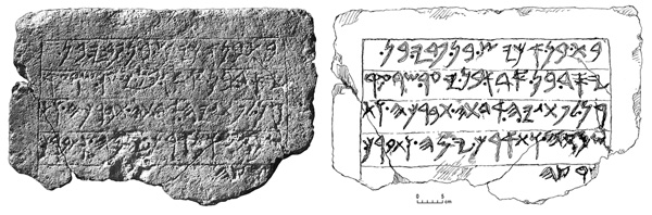
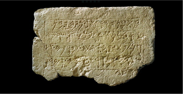
The most important find from Ekron is the royal dedicatory inscription from the cella, room t in the sanctuary of temple complex 650. It not only demonstrates foreign influences, but also represents the continuity of local Philistine traditions. The inscription is complete, and consists of 5 lines and 72 letters. It reads: “The temple (which) he built, ’kys (Achish, Ikausu) son of Padi, son of Ysd, son of Ada, son of Ya‘ir, ruler of Ekron, for Ptgyh his lady. May she bless him, and prote[ct] him and prolong his days, and bless his land.” The inscription records the dedication of the sanctuary by Ikausu, son of Padi, both of whom are referred to as kings of Ekron in seventh-century royal Neo-Assyrian annals.
Ikausu is the only non-Semitic name among the eighth- and seventh-century Philistine kings mentioned in Assyrian records, and means the Achaean, or the Greek. This is further evidence of the early Iron Age I Aegean ethnic origin of the Philistines and of the continuity of Philistine culture. Further corroboration may be seen in the name of the non-Semitic goddess, Ptgyh, referred to in the inscription as the patron of the dynasty and of Ekron. The name Ptgyh has been associated with the sanctuary at Delphi known as Pytho, the shrine of Gaia, the Mycenean mother-goddess.
What makes this inscription unique at the site is that it is the only such inscription found in situ in a securely defined archaeological context within a datable destruction level, that of stratum IB, and it confirms the identification of Tel Miqne as Ekron. The inscription also provides a basis for determining the date of the construction of temple complex 650. It is reasonable to assume that the reign of Ikausu began at or around the time he is first mentioned in the royal annals of the Neo-Assyrian king Esarhaddon. This would support a date no later than the first quarter of the seventh century BCE, which is consistent with the stratigraphic data.
The inscription, together with its architectural context and associated material finds, offers new possibilities for analyzing the impact of the Neo-Assyrian Empire on the Levant, and the period of the pax Assyriaca during the seventh century. This is especially true with regard to the historical correlation between the inscription and the Neo-Assyrian annals, making it the primary document for establishing the chronology of events that occurred in the later days of the biblical period.
TRUDE DOTHAN, SEYMOUR GITIN
Color Plates
EXCAVATIONS
The Tel Miqne excavations, begun in 1981, were concluded in 1996 after 14 seasons of fieldwork. The project was sponsored by the W. F. Albright Institute of Archaeological Research and the Institute of Archaeology of the Hebrew University of Jerusalem, and directed by T. Dothan and S. Gitin. It was affiliated with the American Schools of Oriental Research and the Israel Exploration Society, and supported by a consortium of 22 American, Canadian, and Israeli institutions.
During the six most recent seasons of excavation (1992–1996), fieldwork continued in the upper (field I) and lower city (fields II, III, IV, and X). On the summit of the northeast acropolis (field I), the occupation levels of the Late Bronze Age II through the Iron Age II (strata VIII–I) were further defined. In 1995–1996, in a newly opened sub-field immediately north of and parallel to the original sondage begun in 1981, further evidence was uncovered of the end of the Late Bronze Age II (stratum VIII) and of the earliest elements of the first Philistine city (strata VII–VI), including the construction phase of its city wall. In the lower city, excavations continued in 1992–1996 at the center of the southern ridge (field III), north of the Iron Age I city wall, in which four phases of the Iron Age I city (strata VII–IV) and a Middle Bronze Age II rampart (stratum XI) were uncovered. In the center of the lower city, in the elite zone (field IV lower), excavations continued in 1992–1995, producing the most extensive sequence of Iron Age I occupation (strata VII–IV), as well as further evidence of Iron Age IIC (strata IC–B). In 1992, east of the Iron Age II city gate (field III), a large extension of the late Iron Age II (stratum IB) olive-oil industrial zone (field II) was defined. In 1995–1996, two new fields were opened in the lower city. In the elite zone (field IV upper), a new Iron Age IIC late Philistine monumental building complex (stratum IB) was uncovered; it extended to the slope of the northwest acropolis (field V), where there were also Roman and Islamic remains. In the northwestern corner of the mound (field X), a section of the Middle Bronze Age II rampart (stratum XI) was found immediately below the Iron Age I city wall. Several buildings, including a cultic area from the earliest Philistine city (strata VII–V), were constructed against this wall.