Naḥal Tanninim Reservoir
INTRODUCTION
W. Lynch visited the Tanninim Dam and adjacent mills in 1848, and W. M. Thomson went to the site in 1857. The Palestine Exploration Fund surveyors inspected the dam in 1872 and mentioned the reservoir as the source of the low-level aqueduct to Caesarea. G. Schumacher described the North Dam in 1887. S. Avitzur studied the Tanninim Dam and the adjacent mills in the 1940s and 1950s, J. Oleson in 1974–1975, and T. Schoiler in 1984. Y. Peleg summarized the body of knowledge on the reservoir and the dams up to the late 1980s. Y. Porath, of the Israel Antiquities Authority (IAA), directed excavations of a mill on the North Dam in 1997–1999. The IAA carried out extensive excavations at the Tanninim Dam and its surroundings in 2000–2005, directed by A. -S. Sa‘id, ‘U. ‘Ad, and P. Gendelman.
EXCAVATION RESULTS
The results of the excavations were attributed to three main periods: the pre-reservoir phase, up to the late third century CE; the main reservoir and dam phase, in the fourth–seventh centuries CE; and a period of decline and neglect, beginning with the Muslim conquest in 640/641 CE.
THE PRE-RESERVOIR PHASE. Belonging to the pre-reservoir phase are three burial caves later flooded by the reservoir, kurkar quarries, and the remains of the lower aqueduct. The westernmost of the caves contained three sarcophagi made of soft limestone in the “Samaritan” style, typical of the second–third centuries CE. The lower aqueduct was exposed over 450 m south of
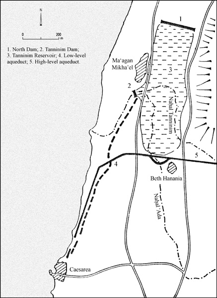
THE RESERVOIR PHASE. The Tanninim Reservoir provided water to Caesarea and Dor, and powered mills. The construction of the Tanninim Dam, the North Dam, and the low-level aqueduct is not mentioned in any extant historical document, but the finds revealed in foundation trenches and in the burial cave later flooded by the reservoir indicate that the entire system was created in the fourth century CE.

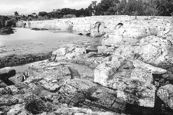
The Tanninim Dam. The Tanninim Dam is a 193-m-long gravitation dam that stretches across

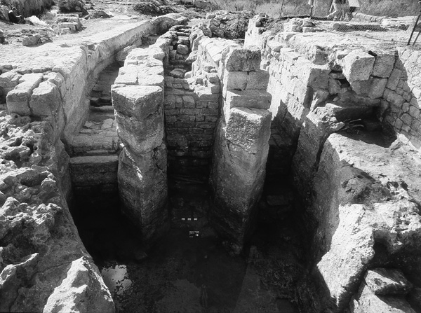
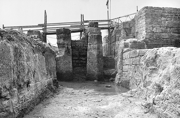
The quarrying of a 3.6–4.5-m-wide diversion channel into the southern side of the valley preceded the actual construction of the dam. Two partitions (8.15 by 1.37 m) were left unquarried in the diversion channel, creating three passages (P1–P3) planned to be incorporated into the dam’s sluice.

The sluice is located in the southern sector of the Tanninim Dam. It was composed of three passages and a diversion pond. The lower part of the passages was quarried into the kurkar (each 1.3 m wide, threshold at 1.45–1.55 m above sea level), and the upper was constructed. Three vertical slots for the sluice gates were cut into the partitions between the passages; wooden planks of cypress from an early phase of the gate were found blocking passages P1 and P2. The threshold of the three passages was raised to 3.59–3.88 m above sea level in the sixth century CE. The diversion pond (c. 7 by 5 m) was created by closing a segment of the diversion channel west of the passages. The water that crossed the passages was diverted from the pond towards the low-level aqueduct and the mills. The number of mills increased in the subsequent stage and the water was diverted into the wide quarried channel C1 (2.9 m wide in the east and narrowing to 1.1 m at the western edge; floor level at 3.3 m above sea level). A larger, window-shaped opening (0.4–0.7 by 2.1 m, threshold at 3.38 m above sea level) replaced the original opening (0.4 by 1.2 m, threshold at 4.15 m above sea level). The floor of the diversion pond was then elevated. Finds revealed in the fill indicate that these changes were also carried out in the sixth century CE.

The North Dam. The North Dam (c. 950 m long, 2.2–2.4 m wide, preserved to a maximum elevation of 6.54 m above sea level) runs between the Carmel Range and the kurkar crest. It was built of a concrete core between outer faces of large blocks. Rectangular buttresses (0.7 by 4.5 m) supported the dam’s outer face. Its construction is dated to the fourth century CE on the basis of sherds revealed in its foundation trench.
The Low-Level Aqueduct. The low-level aqueduct conveyed the reservoir water southward to Caesarea. The segment adjacent to the diversion pond was quarried into the kurkar bedrock; a segment was then constructed in the eastern side of a pre-reservoir quarry. From that point it followed the course of the lower aqueduct, widening the earlier channel (to 1.7–1.8 m wide, its floor at 4.2–4.5 m above sea level). The low-level aqueduct left the course of the lower aqueduct 250 m south of the Tanninim Dam. The initial intake of the low-level aqueduct was through the upper window of the diversion pond, but during the Byzantine period it shifted to passage P4 (1.55 m wide, threshold at 5.5 m above sea level), and later moved 45 m southward to passage P5 (threshold at 5.2 m above sea level). The travertine incrustation on the channel’s walls reaches up to 6.3 m above sea level near Caesarea, indicating that the level of the Tanninim Reservoir in the Byzantine period was c. 6.5 m above sea level.
The Mills. Six water-powered flourmills were operated west of the diversion pond in the Byzantine period, their lower parts quarried into the kurkar bedrock. A vertical pedal-wheel (diameter c. 2.2 m) in an under-shot mill race-channel turned the mills. A rectangular room on each side of the pedal-wheel contained the gear to change the horizontal axis of the wheel to vertical for the millstone. Each mill consisted of two sets of Pompeian millstones (also referred to as donkey millstones). A vertical hole cut in the lower conical millstone (meta) endorsed the change from muscle power to water power. The sherds found in the mills all date to the sixth–seventh centuries CE. They lack any sign of later use.
THE RESERVOIR PRIOR TO DRAINING. The decline of Caesarea after the Arab conquest (640/641
The earliest post-Byzantine mills of the Tanninim Dam were three aruba/penstock mills with two horizontal pedal-wheels, each to move one set of disk-shaped millstones. They apparently date to the Mameluke–early Ottoman period (fourteenth–sixteenth centuries
In 1922, the Tanninim Dam was breached in order to drain the reservoir following the purchase of the land by Baron Edmond de Rothschild. The Tanninim Reservoir then ceased to exist and the water-powered flourmills stopped functioning.
YOSEF PORATH, UZI ‘AD, ‘ABD EL-SALAM SA‘ID, PETER GENDELMAN
INTRODUCTION
W. Lynch visited the Tanninim Dam and adjacent mills in 1848, and W. M. Thomson went to the site in 1857. The Palestine Exploration Fund surveyors inspected the dam in 1872 and mentioned the reservoir as the source of the low-level aqueduct to Caesarea. G. Schumacher described the North Dam in 1887. S. Avitzur studied the Tanninim Dam and the adjacent mills in the 1940s and 1950s, J. Oleson in 1974–1975, and T. Schoiler in 1984. Y. Peleg summarized the body of knowledge on the reservoir and the dams up to the late 1980s. Y. Porath, of the Israel Antiquities Authority (IAA), directed excavations of a mill on the North Dam in 1997–1999. The IAA carried out extensive excavations at the Tanninim Dam and its surroundings in 2000–2005, directed by A. -S. Sa‘id, ‘U. ‘Ad, and P. Gendelman.
