
Palmaḥim Quarry
INTRODUCTION
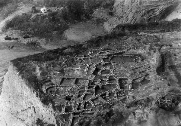
Nothing is known of archaeological deposits in the area above the burial caves, but later work established that the remainder of the ridge, areas A–D, was covered by archaeological deposits resting atop bedrock. Work in areas A and C was abandoned when they were shown to be so severely damaged by quarrying that further effort was not worthwhile. Areas B and D were eventually excavated, but budgetary and time constraints produced only partial results for these very large tracts of the site. Unfortunately, most archaeological deposits in all areas were eventually destroyed by continued quarrying. In addition, the shearing of the top of the ridge for quarrying exposed scores of pits in the bedrock; they are of different sizes and shapes, and are in varying states of preservation. Today, only a small fraction of the ridge remains.
| STRATIGRAPHY OF |
Phase | Area A | Area B | Area C | Area D | SW of Area D |
|---|---|---|---|---|---|
| Bedrock matrix | Pits of unknown date | Pits of unknown date | Pits of unknown date | Pits of unknown date | Burial caves |
| Late Neolithic-Early Chalcolithic, 6th–5th millennia BCE | Scattered finds | ||||
| Late Chalcolithic, Late 5th–early 4th millennia BCE | Scattered finds | Scattered finds | Destroyed prior to excavation; pits | Scattered finds | Quarried burial caves |
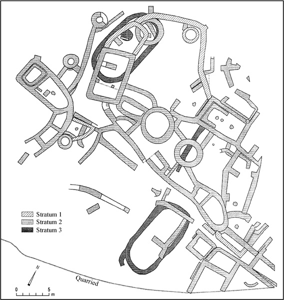
| Initial EB I, c. 3500 BCE | Destroyed prior to excavation | Settlement, stratum 3; pits | Settlement (?), severely damaged by quarrying | Settlement, stratum 3 (?) | |
| Advanced EB I, c. 3150–3000 BCE | Destroyed prior to excavation | Settlements, strata 2, 1 | Settlement, probably strata 2, 1; severely damaged by quarrying | Destroyed prior to excavation | Secondary use of caves for burial |
EXCAVATION RESULTS
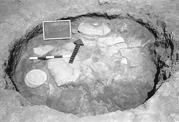
PITS HEWN IN BEDROCK. All of the pits, with a single exception in area B, were revealed after quarrying had removed the uppermost surface of the kurkar hillside beneath archaeological deposits. Most pits appear to have been round and less than 2 m in diameter. Only a few pits could be excavated. Their date remains obscure, as does their function. One cylindrical pit in area D was in secondary use for a primary burial in flexed position without grave goods, laid on earthen fill c. 60 cm above the pit floor. Others contained pottery, including small, straight-sided bowls (area C), and large fragments of pithoi datable to either the late Chalcolithic period or the initial Early Bronze Age I (area B). Still others contained deposits of carbonized material (area C).
THE LATE NEOLITHIC–EARLY CHALCOLITHIC PERIODS. Scattered flint artifacts and potsherds, found on or near bedrock in area B, or in fills associated with later periods in that area, suggest utilization of the summit of the ridge during the late Neolithic–early Chalcolithic periods. No other definitive information on them has been forthcoming from excavations, but a single inhumation in a secondary utilization of a pit (area D) could possibly have originated in one of these periods.
THE LATE CHALCOLITHIC PERIOD. During several decades of modern quarrying, 11 partially preserved late Chalcolithic period cave tombs were salvaged through excavation in a precinct of the site southwest of area D. The same tombs had been reused for burials in late phases of Early Bronze Age I. Late Chalcolithic period objects were also recovered either scattered or in small concentrations in crevices in the bedrock in areas A, B, and D.
THE INITIAL EARLY BRONZE AGE I. Large-scale salvage excavations unearthed more than 1,500 sq m of stratum 3 (areas B and D), an initial Early Bronze Age I occupation situated directly atop the kurkar bedrock. Dating is based on ceramics that include bowls of gray-burnished ware and pithoi types common at sites in the north (e.g.,
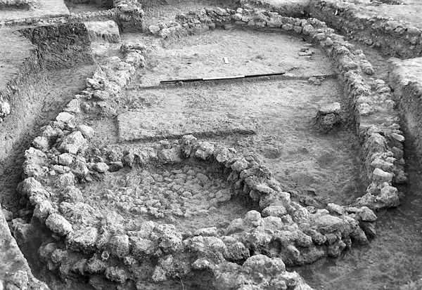
In area B, two relatively large, deep soundings yielded substantial, well-preserved stone foundations of two sausage-shaped houses, their ground plans completely preserved. Additional stone wall foundations indicate further structures, but these remain unexcavated. A deep, bell-shaped pit found nearby is probably to be associated with this stratum as well. As in houses at contemporary sites (e.g.,
Subsequent to quarrying, some severely damaged archaeological deposits in area D were excavated. They were found to be additional remains of an initial Early Bronze Age I occupation above bedrock, apparently a continuation of stratum 3 in area B. Excavation yielded only short, poorly preserved wall segments, some rectilinear and others curvilinear. The settlement could be dated by associated deposits of fragmentary ceramic vessels of types known from stratum 3.
THE ADVANCED EARLY BRONZE AGE I VILLAGE. Evidence for an occupation and utilization of the site dated to the latter part of Early Bronze Age I may have been spread out over much of this once massive, kurkar promontory, but it was directly encountered only in areas B and C and in secondary utilization of late Chalcolithic burial caves. Two successive strata (2 and 1) are a reflection of a continuous occupation of the site in area B.
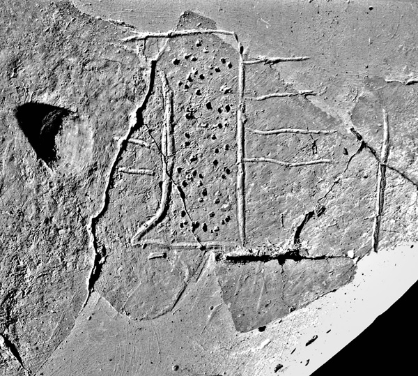
The earlier level, stratum 2, is dated to a phase equivalent to that of stratum C at Tel ‘Erani. A notable find from this level was the upper portion of a large, locally made storage jar incised before firing with an Egyptian royal symbol (serekh). This object is probably to be associated with an Egyptian ruler of the Proto-Dynastic period (i.e., early in Dynasty 0) and is important for chronological correlations between the southern Levant and Egypt. A similar serekh appears on a jar with an unusual rim, also incised before firing, from
In stratum 1 many of the houses continued in use, although they underwent slight changes in plan, either in the raising of floor levels, the rebuilding of walls, or the addition of rooms. One narrow lane was closed off; several rooms were constructed directly above it. A chamber appears to have served as a repository for foodstuffs, as small quantities of carbonized legumes were recovered in its earth fill. These legumes yielded a radiocarbon determination that dates this village from sometime in the late fourth to the early third millennium BCE, a time span consistent with generally accepted chronologies.
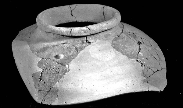
Pottery associated with strata 2 and 1 displays relatively little change over time, with similar vessel types and styles found in both levels. They appear to reflect regional parochialism that suggests close ties with other contemporary sites in the central littoral and Shephelah. These regional parameters are especially notable in jars slipped in white lime and painted over with narrow, vertical red stripes; jugs; bowls; profiled hole-mouths; and large vessels decorated with flat, horizontal strips of clay, depressed at regular intervals in imitation of rope. Similar types are found at contemporary occupations (e.g.,
The faunal and chipped-stone and groundstone assemblages indicate that the economic basis of this community was both agricultural and pastoral. Indeed, in the immediate vicinity of the site are the fertile littoral and a plentiful water supply from the adjacent stream, as well as shallow deposits of fresh groundwater at the base of the ridge. A few fish bones, a copper fishhook, and remains of a sea-turtle shell attest to at least minimal utilization of nearby marine resources.
There is some suggestion of a major increase in population from stratum 2 to stratum 1, which may have caused overcrowding in what was an already densely built-up environment. Such a tendency is concomitant with large aggregations of population and increasingly complex societies that developed in late Early Bronze Age I. For reasons unknown, the site was abandoned, apparently peacefully, prior to the onset of Early Bronze Age II, as indicated by a complete lack of pottery types of that period.
ELIOT BRAUN
INTRODUCTION
Nothing is known of archaeological deposits in the area above the burial caves, but later work established that the remainder of the ridge, areas A–D, was covered by archaeological deposits resting atop bedrock. Work in areas A and C was abandoned when they were shown to be so severely damaged by quarrying that further effort was not worthwhile. Areas B and D were eventually excavated, but budgetary and time constraints produced only partial results for these very large tracts of the site. Unfortunately, most archaeological deposits in all areas were eventually destroyed by continued quarrying. In addition, the shearing of the top of the ridge for quarrying exposed scores of pits in the bedrock; they are of different sizes and shapes, and are in varying states of preservation. Today, only a small fraction of the ridge remains.