Qiryat Ata
INTRODUCTION
Qiryat Ata is located 6 km southeast of the present-day Mediterranean coast, 6 km northeast of the Qishon River and 5 km east of Haifa. The modern town derives its name from the abandoned Arab village of Kufreita or Kufr Etta, which was inhabited until the beginning of the twentieth century. Proximity to the rich alluvial soils of the Zebulun Valley and the nearby Qishon River attracted settlement to this region as early as the Neolithic period. The modern-day town is rich in archaeological remains, which include a Byzantine church, excavated by F. Vitto on behalf of the Israel Department of Antiquities in 1973; and various tombs, installations, and other architectural remains of the Roman, Byzantine, and Islamic periods located primarily in and around the abandoned Arab village. The site was surveyed by the late Y. Olami in 1965, who collected pottery from the Early Bronze, Middle Bronze, and Iron Ages and the Byzantine period, and defined the extent of the occupation. Intensive development in recent years has damaged many of the archaeological remains.
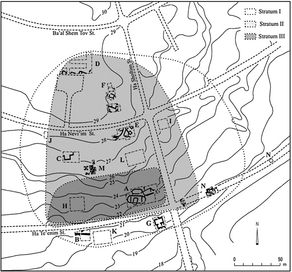
The Early Bronze Age settlement of Qiryat Ata is situated within a residential neighborhood at the southern extremity of the modern-day town, on the moderate slope of a low ridge and in proximity to the valley floor. The existence of an Early Bronze Age occupation was first established in 1945 when excavation of a Roman loculus tomb revealed an earlier cave containing Early Bronze Age II ceramic remains, later published by R. Amiran. Since 1990, a series of salvage excavations has taken place in the area of the Early Bronze Age site. As of 2006, 18 areas (A–R) have been investigated by various institutions, including the Israel Antiquities Authority (areas A–G, N, O, by A. Golani; area J, by Y. Lehrer; areas M and P, by A. Abu-Hamid; and areas Q and R, by M. Taber), Bar-Ilan University (area H, by E. Baruch and D. Inbar), Tel Aviv University (area L, by A. Fantalkin), and the University of Haifa (area I, by S. Sourkis and M. Eisenberg; and area K, by J. Gottlieb).

EXCAVATION RESULTS
The site was initially settled in the Late Neolithic (Wadi Rabah) period, evidenced by a layer of occupational debris upon bedrock in area L. A very limited amount of Chalcolithic pottery and flint tools has been recovered in some of the excavated areas, but no remains of this period have yet been found in situ. The site was resettled in the Early Bronze Age IB and was continuously occupied until well into the Early Bronze Age II, when it was again abandoned. The lack of subsequent occupation over the Early Bronze Age remains enabled the widespread exposure of architectural remains of that period, the latest of which were found directly below the modern ground surface. A continuous stratigraphic sequence spans the transition from the Early Bronze Age I to the Early Bronze Age II, a critical period when early Canaanite society underwent the first stages of an urbanization process. Three major strata of the Early Bronze Age I–II may be defined at the site.
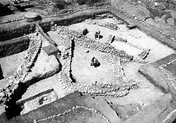
STRATUM III. The stratum III settlement, dated to the Early Bronze Age IB, was identified only in the southern portion of the site (areas A, H, and O), adjacent to the valley floor. This settlement was limited in size, apparently not exceeding 2 a., and characterized by a random array of oval or elliptical buildings. Three nearly complete and relatively well-preserved structures were excavated in area A, one measuring 18 m in length with an apse hewn into the bedrock. Beneath the rock floor of the apse was a small, artificially enlarged cave, entrance to which was from within the apse. The other walls were built of mud bricks upon a stone foundation. At the base of one of the building’s walls a cache of copper tools was discovered, apparently a foundation deposit, containing a semicircular plate upon which was placed a dagger and a complete axehead. Copper chisels had been laid out on either side of the axehead. In area A, stratum III came to an end with the violent destruction of all three buildings, leaving a wealth of crushed pottery vessels and other finds upon the floors. Similar oval buildings have been excavated in area O and curvilinear architecture has also been exposed in area H.

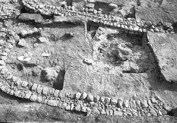
STRATUM II. The site was immediately reoccupied in stratum II, dating to a very late stage of the Early Bronze Age IB. The settlement nearly quadrupled in size, expanding northwards to encompass an area of at least 7 a. Stratum II is characterized by rectangular buildings with rounded corners. In area A, these structures were found superimposed upon the curvilinear buildings of stratum III; while in areas D, E, and N, buildings with rounded corners were founded upon the bedrock. Stratum II is notable for the planned layout of the buildings, all of which were built in the same northeast–southwest orientation, separated by streets and alleyways.
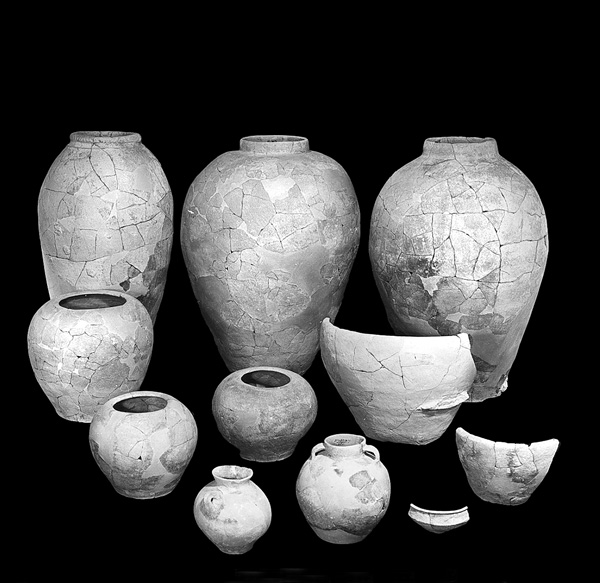
The ceramic assemblage of stratum II is virtually identical to that of stratum III, both of which are characterized by the predominant use (75 percent) of a red wash surface treatment on all vessel types. This ceramic repertoire is typical of the northern Canaanean culture of the Early Bronze Age IB and includes gray burnished bowls, “teapots” with bent spouts, hole-mouth jars, bow-rim pithoi, and storage jars with band slip decoration.
STRATUM I. The remains of stratum I, dating to the early stage of the Early Bronze Age II, were found directly upon those of stratum II, often reusing or cutting through that stratum’s architectural remains. During the Early Bronze Age II, the settlement grew further in size, encompassing an area of at least 10 a. This settlement, characterized by rectilinear architecture, was the most extensive and intensive Early Bronze Age occupation at the site and was identified in every excavation area. Wherever excavated, stratum I remains were revealed as a dense cluster of buildings. In the central portion of the site (areas C, E, F, M), at least three stratified architectural phases were observed in up to 2 m of accumulation.

The excavations in area O, located on the southern margins of the site, revealed the very base of a fortification wall, 3.0–3.5 m wide and exposed for 21 m. Outside and adjacent to this wall was a sloping glacis of small stones, apparently intended to prevent the erosion of the earth upon which the wall was founded. Inside the wall, a small portion of an open area or street was revealed. The wall was likely constructed toward the beginning of the Early Bronze Age II, as successive modifications of many of the Early Bronze Age II structures uncovered throughout the excavated areas are evidence that construction became more dense over time, probably a result of the site’s growth within a restricted area.

Localized destructions were found in some of the stratum I architectural phases, revealing a wealth of finds including numerous intact and restorable ceramic vessels. In area F, destruction debris upon a floor produced a hoard of semi-precious stone beads within a small Abydos-type jug. The stratum I occupation also produced a corpus of more than 12 cylinder seal impressions, mostly geometric patterns impressed on storage jars of metallic ware, some of which originated in sealed stratigraphic contexts. The large amount of metallic ware found within the rooms of the buildings is also noteworthy. This family, which includes both large and small utilitarian vessels in a wide variety of open and closed forms, comprised close to half the entire stratum I ceramic assemblage. Recent studies have shown the ware to have originated in the foothills of Mount Hermon or in southern Lebanon, indicating that these vessels were all imported to the site.

SUMMARY
At Qiryat Ata, buildings of the Early Bronze Age IB–Early Bronze Age II transition evolved from curvilinear (stratum III), to rounded-corner (stratum II), to rectilinear (stratum I) structures. This process reflects the adaptation of urban Canaanite society to more rectilinear architectural forms, which are easily suited to an ordered urban plan and facilitate a more efficient use of space.

The ceramic repertoires of the Early Bronze Age IB and the beginning of the Early Bronze Age II at Qiryat Ata derive from well-defined contexts and can provide a firm basis for comparative studies and the dating of similar assemblages from northern Canaan. The large amount of stratified imported metallic ware found in stratum I highlights the centralization of pottery production and distribution at the beginning of the Early Bronze Age II in northern Canaan. This could only have been the result of an efficient and well-developed trade and distribution network that was capable of safely transporting large amounts of commodities. Such a network, in turn, suggests the existence of a well-organized political entity, possibly centered around one or more of the city-states whose authority extended over the region where this ware was most prevalent.
AMIR GOLANI
INTRODUCTION
Qiryat Ata is located 6 km southeast of the present-day Mediterranean coast, 6 km northeast of the Qishon River and 5 km east of Haifa. The modern town derives its name from the abandoned Arab village of Kufreita or Kufr Etta, which was inhabited until the beginning of the twentieth century. Proximity to the rich alluvial soils of the Zebulun Valley and the nearby Qishon River attracted settlement to this region as early as the Neolithic period. The modern-day town is rich in archaeological remains, which include a Byzantine church, excavated by F. Vitto on behalf of the Israel Department of Antiquities in 1973; and various tombs, installations, and other architectural remains of the Roman, Byzantine, and Islamic periods located primarily in and around the abandoned Arab village. The site was surveyed by the late Y. Olami in 1965, who collected pottery from the Early Bronze, Middle Bronze, and Iron Ages and the Byzantine period, and defined the extent of the occupation. Intensive development in recent years has damaged many of the archaeological remains.
The Early Bronze Age settlement of Qiryat Ata is situated within a residential neighborhood at the southern extremity of the modern-day town, on the moderate slope of a low ridge and in proximity to the valley floor. The existence of an Early Bronze Age occupation was first established in 1945 when excavation of a Roman loculus tomb revealed an earlier cave containing Early Bronze Age II ceramic remains, later published by R. Amiran. Since 1990, a series of salvage excavations has taken place in the area of the Early Bronze Age site. As of 2006, 18 areas (A–R) have been investigated by various institutions, including the Israel Antiquities Authority (areas A–G, N, O, by A. Golani; area J, by Y. Lehrer; areas M and P, by A. Abu-Hamid; and areas Q and R, by M. Taber), Bar-Ilan University (area H, by E. Baruch and D. Inbar), Tel Aviv University (area L, by A. Fantalkin), and the University of Haifa (area I, by S. Sourkis and M. Eisenberg; and area K, by J. Gottlieb).
