
Rosh Pina
INTRODUCTION
The ancient site of Rosh Pina covers a c. 25-a. area on a limestone spur, 450–500 m above sea level. The spur extends in a southeasterly direction above springs along
From the results of the survey it became clear that within the area of the modern Jewish settlement of Rosh Pina, located just east of Ja‘unah, is a tell covering an area of c. 10 a. In the area of the tell were collected sherds from the Early Bronze Age I and II, Middle Bronze Age I, Middle Bronze Age II, Iron Age I–II, and the Persian, Hellenistic, and later periods. The large number of Iron Age sherds, including a fragmentary figurine of a female holding a tambourine, suggests a flourishing settlement in this area during that period.
EXCAVATIONS
In the summer of 2002 and the beginning of 2003, following a development plan for the boulevard adjacent to the Dr. Mer and Pika Houses in the modern Jewish settlement, archaeological excavations covering an area of c. 100 sq m were conducted by the Israel Antiquities Authority along this road, funded by the Regional Council, the Government Tourist Corporation, and the Jewish National Fund. Iron Age, Hellenistic, Early and Late Roman, Byzantine, and Early Islamic period building remains were encountered in the excavations.
EXCAVATION RESULTS
THE IRON AGE. A 2.5-m-long wall preserved to a height of 1.6 m was found in the western part of the excavation area. It is a fieldstone wall oriented southwest–northeast, founded upon bedrock, and dated to the beginning of the Iron Age (c. eleventh century BCE). Associated with the wall were remains of a terrace wall and a pit lined with fieldstones. Near these, to the north, was unearthed part of a 0.5-m-thick burnt layer containing remains of bricks, wood charcoal, and pieces of red-painted plaster. This attests to an established settlement with a high standard of architecture. Similar evidence of walls covered in red plaster has been found at Sasa in the Upper Galilee. The settlement appears to have been constructed during the Iron Age I and violently destroyed during the Iron Age IIA (tenth century BCE). Discovered in the vicinity were a few fragmentary building remains that apparently belong to the Iron Age II. Likewise, remains of a Late Roman period wall were found covering part of the Iron Age destruction layer.
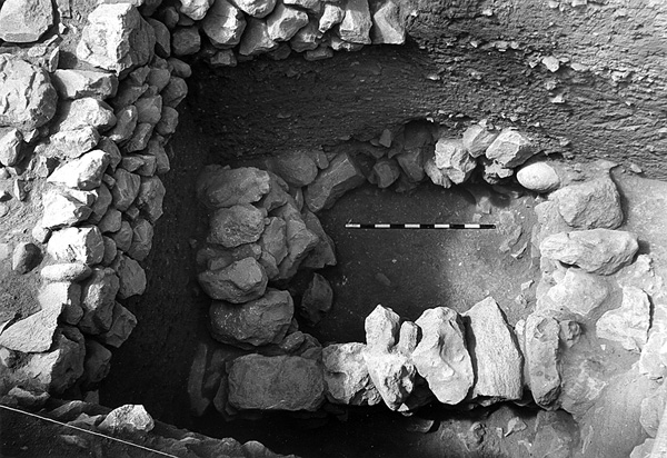
In the eastern part of the excavated area, some 10 m northeast of the western area but at an elevation 3 m lower, remains of walls from two rectangular structures built of hard limestone fieldstones and preserved to a height of 1.5 m were exposed. A roughly 3-by-2-m portion of each building was uncovered. The walls were erected in an earthen fill containing red plaster, similar to the plaster fragments in the destruction layer excavated in the western excavation area. Even though no floors were discovered in the buildings, the pottery found there—such as jars, kraters, cooking pots, chalices (possibly for cultic use), and some imports—attest to the use of the structure during the Iron Age IIB, around the ninth century BCE. The dating of the structures to this period strengthens the attribution of the previous stratum to around the tenth century BCE. Additional Iron Age finds from the eastern area include a complete stone roller as well as fragments of a well-made basalt bowl with tripod base, which has very close parallels dated to the ninth century BCE at Rosh Zayit.
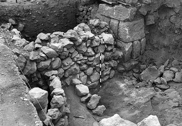
THE HELLENISTIC PERIOD. The western excavation area produced a 2-m segment of a well-built second-century BCE wall of large limestone ashlars, laid in alternating courses of headers and stretchers, similar to a Phoenician masonry style encountered at Dor and other coastal sites. Earlier Iron Age remains were destroyed during the construction of this wall. It was certainly part of a large public building that extends beneath the houses of the modern settlement. It was probably this building that was referred to as the synagogue in the tradition of the local Arab inhabitants of Ja‘unah. The modern Jewish settlers drew on this tradition in selecting a nearby site for the construction of their synagogue. The building is dated to the second century BCE, on the basis of a Rhodian jar handle found at the bottom of the wall’s foundation trench; the handle bears a seal impression with a Greek inscription from 171 BCE. The structure may have been destroyed by the Hasmoneans, who conquered the Galilee at the end of the second or beginning of the first century BCE, suggested by a coin of Alexander Jannaeus found a few meters east of the wall in the eastern excavation area.
THE ROMAN PERIOD. A 4-m-long wall running northwest–southeast, well constructed of trimmed stones, was discovered in the southern part of the eastern excavation area, near the Dr. Mer House. Segments of other walls associated with this wall and remains of a plastered installation found north of the western excavation area are all attributed to the Roman period. Another 4-m-long wall found in the western excavation area and covering Iron Age remains is also attributed to the Late Roman period.
THE BYZANTINE AND EARLY ISLAMIC PERIODS. A few wall segments exposed in the eastern excavation area, 1–1.5 m beneath the surface, are attributed to the Byzantine and Early Islamic periods. The finds include ceramic lamps and a small number of coins.
YOSEF STEPANSKY
INTRODUCTION
The ancient site of Rosh Pina covers a c. 25-a. area on a limestone spur, 450–500 m above sea level. The spur extends in a southeasterly direction above springs along
From the results of the survey it became clear that within the area of the modern Jewish settlement of Rosh Pina, located just east of Ja‘unah, is a tell covering an area of c. 10 a. In the area of the tell were collected sherds from the Early Bronze Age I and II, Middle Bronze Age I, Middle Bronze Age II, Iron Age I–II, and the Persian, Hellenistic, and later periods. The large number of Iron Age sherds, including a fragmentary figurine of a female holding a tambourine, suggests a flourishing settlement in this area during that period.