Rujm Jerida is located on a hilltop, 596 m above sea level, in the southwestern Hebron Hills, c. 1 km south of Khirbet ‘Anab el-Kebir and c. 2 km southeast of Eshkolot. It was noted by D. C. Baramki in 1942, M. Kochavi in 1967, and Z. Safrai in the early 1980s. Excavations were carried out at the site in 1997 by Y. Magen, Y. Peleg, and I. Sharukh on behalf of the Staff Officer for Archaeology in Judea and Samaria.
EXCAVATION RESULTS
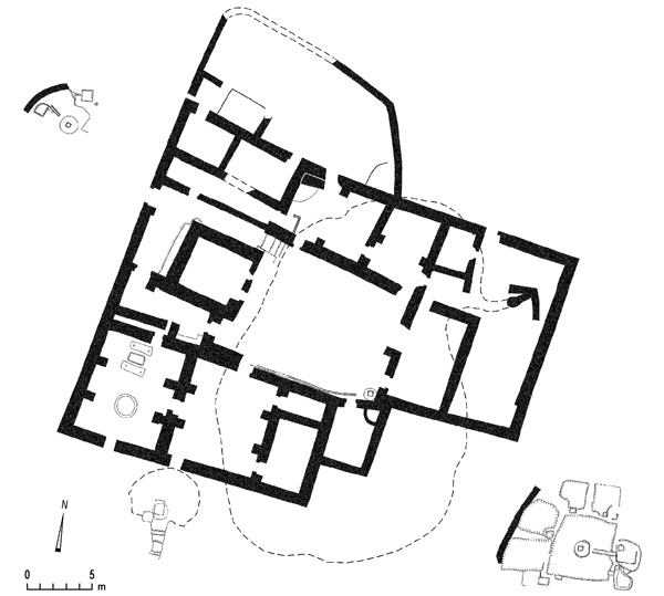
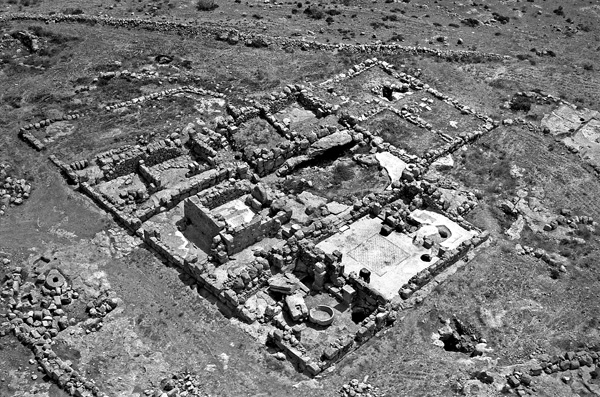
Four phases of occupation were found at the site, which measures 32 by 27 m. The first is dated to the fourth century CE, when a tower was constructed above a natural cave; the second to the sixth century CE, when a large farmhouse was erected around the fortified tower. Later in the sixth century the farmhouse became a monastery or a farmhouse inhabited by Christians. During the fourth phase, in the Early Islamic period (the seventh to ninth centuries ce), changes were made to the building and an olive-oil press was added.
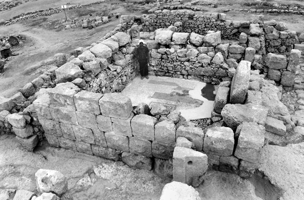
The tower at the center of the site is square, 5.9 by 5.9 m, constructed to the west of the large cave that forms the nucleus of the site. It appears to have been used for protection against nomadic raiders. It has ashlar walls and an opening facing east, 0.8 m wide, with two doorposts. A single wooden door panel with two strong bolts would have sealed the narrow opening. In times of turmoil, the opening could also be closed by a rolling stone, 1.45 m in diameter, which remains in situ in the northern part of the tower’s eastern wall. The rolling stone appears to have been a later addition, possibly indicating deteriorating security conditions in the region.
In the sixth century CE, the farmhouse was built around the tower and above the cave. It consisted of three annexes surrounding a central courtyard: a residential annex to the north, an additional open courtyard to the east, and a public wing, including a chapel, to the south. During this phase, the tower was paved in a white mosaic floor with a central carpet of a colorful geometric design. At the center of the farmstead was a rectangular courtyard measuring 12 by 9 m, with a staircase in its northern part descending to the cave below, and a cistern in its southeastern corner. Most of the courtyard’s floor collapsed; only its southeastern portion, with remains of a colorful geometric mosaic, survived. A portico in the eastern part of the courtyard is suggested by the remains of piers there. The northern residential wing of the farmhouse had five rooms; the eastern wing, two rooms and a courtyard with another opening to the cave; and the southern wing, three rooms: a central room with a geometric mosaic pavement, an eastern chapel that was also paved in a geometric mosaic and contained the remains of a Greek inscription, and a large western room.
The inhabitants of the farmhouse also used a small plastered cave, 5.1 m across, some 5 m south of the farmhouse. It was approached via a narrow, six-stepped, rock-cut passage. At the end of the passage and at the entrance to the cave was a rolling stone, 1.2 m in diameter, probably used to seal the cave. The cave likely functioned for the storage of liquids, possibly wine produced at the winepress located 10 m southeast of the building. The winepress consisted of a central surface, 4.75 by 4.4 m, paved in white mosaic; four secondary surfaces, some also paved in white mosaic; a depression and storage pits; and a round stone with a square hole in the center used for the final mashing of the pressed grapes.
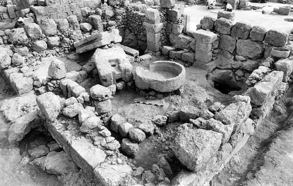
Several changes were made during the final phase of the site, dated to the Early Islamic period (seventh to ninth centuries ce). The western portion of the northern wing in the main building was in use during this period. A number of new walls altered the division of the rooms and two new small rooms and a courtyard were added to the north. The main change was in the southwestern room, which was converted to a grooved-pier olive-oil press. A crushing installation was placed below the southern arch, which supported the room’s ceiling, and a pressing installation consisting of two large crushing stones, 2.05 by 1.15 by 0.5 m, was placed in the northern part of the room on parallel stone slabs, with a sunken basin between them.
YITZHAK MAGEN, YUVAL PELEG, IBRAHIM SHARUKH
THE SITE
Rujm Jerida is located on a hilltop, 596 m above sea level, in the southwestern Hebron Hills, c. 1 km south of Khirbet ‘Anab el-Kebir and c. 2 km southeast of Eshkolot. It was noted by D. C. Baramki in 1942, M. Kochavi in 1967, and Z. Safrai in the early 1980s. Excavations were carried out at the site in 1997 by Y. Magen, Y. Peleg, and I. Sharukh on behalf of the Staff Officer for Archaeology in Judea and Samaria.
EXCAVATION RESULTS
Four phases of occupation were found at the site, which measures 32 by 27 m. The first is dated to the fourth century CE, when a tower was constructed above a natural cave; the second to the sixth century CE, when a large farmhouse was erected around the fortified tower. Later in the sixth century the farmhouse became a monastery or a farmhouse inhabited by Christians. During the fourth phase, in the Early Islamic period (the seventh to ninth centuries ce), changes were made to the building and an olive-oil press was added.