Shoham
INTRODUCTION
The site at bypass road 444, east of the modern town of Shoham, was not discovered during surveys of the area and does not appear on the Map of Lod for the Archaeological Survey of Israel. Its remains were exposed only when the area was being prepared for the construction of the road. It is situated on a shoulder of a gentle slope in the western hills of the Shephelah. A salvage excavation was carried out at the site by U. Dahari and U. ‘Ad, on behalf of the Israel Antiquities Authority, in 1995–1996. An area measuring 130 m by 75 m was excavated and seven occupational strata were identified.
No evidence was found for the ancient name of this large site. Four possible identifications of the site are proposed on historical-geographic grounds: (1) Neballat, a place mentioned in the Bible and in various historical sources, identified today with the ruins of the Arab village Beit Nabala, located about 1 km south of the site. (2) Zeboim, which is mentioned only in Nehemiah 11:34, where it is located between Hadid and Neballat. This identification is problematic because of the paucity of Persian period finds at the site in question, and its location north of Hadid and Neballat. (3) Betomelgezis, which appears only on the Medeba map as a place north of
EXCAVATION RESULTS
STRATUM VIII. The site was sparsely populated during stratum VIII, dated to the end of the Iron Age and the Persian period. The remains of the stratum, consisting of only a few wall segments surviving at the center of the site, do not allow a reconstruction of the settlement plan or scope. A clay figurine of a woman and a few sherds from these periods were found in the lower fills in different parts of the site.
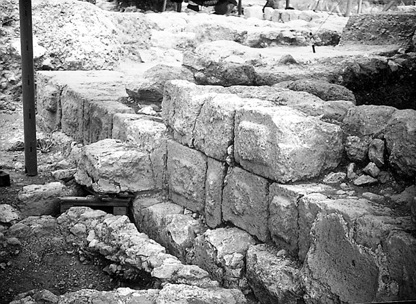
STRATUM VII. Stratum VII dates to the (pre-Hasmonean) Hellenistic period, namely the third and second centuries BCE. In the northern part of the site, three fortified buildings, constructed on a north–south axis, were excavated and found to date to this period. Building 1, 19 by 11 m, was the most elaborate. The outer face of the broad wall was built of large ashlars arranged in headers and stretchers, with marginal drafting and a prominent central boss, in the best Hellenistic tradition. Building 2, 15 by 15 m, was also constructed of large ashlars, without marginal drafting, and had very thick walls (c. 3.5 m). The foundation courses of the outer face were coated in hydraulic plaster. Of building 3, only the lowest course of large ashlars was preserved. The eastern part of this building lay under the church (see below, stratum IV), and its exact dimensions could not be established.
A farm was excavated on the southern part of the site. It included buildings, agricultural processing installations, and cisterns, and extended over an area of about 0.6 a. It was apparently a fortified farm of the type known in the northern Judean Shephelah during the Hellenistic period. The finds included sherds, an Attic lamp, and coins of Seleucid rulers.
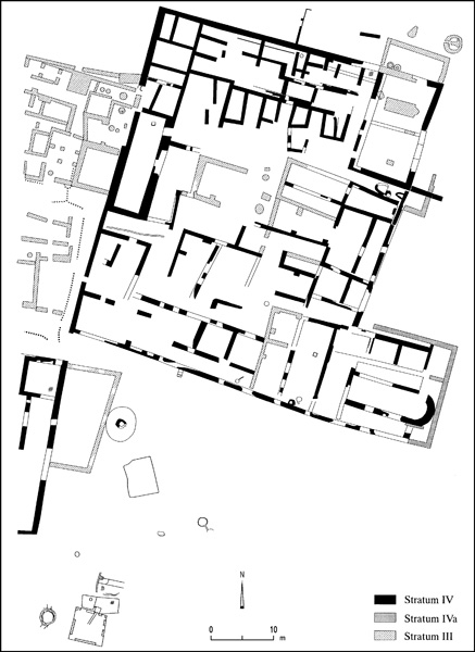
STRATUM VI. Stratum VI, the most interesting and important stratum at the site, is dated to the Hasmonean period. It determined the site’s form in later periods. In the northern part of the site was a well-defended fortress (c. 60 by 48 m) surrounded by a casemate wall. Its walls ranged in width from 1 m to 1.60 m; the distance between the inner and outer walls was c. 5 m. Incorporated into the construction of the walls were numerous stones with crude marginal drafting, looted from buildings of stratum VII. The casemate rooms were used for storage. The fortress’s main entrance was probably in the middle of the western wall; it opened onto a narrow street that led to the main courtyard. A drainage channel ran under the street. Another entrance, approached by a flight of stairs, was in the middle of the southern wall. Many underground networks were uncovered in the area of the fortress, including a water system that conducted run-off water into plastered cisterns. It is possible that some of the mikvehs found in the fortress area (see below, stratum V) originated in this stratum. Numerous coins of Hasmonean rulers, most of them of Alexander Jannaeus, were found in this stratum. The plan of the fortress is similar to that of the Hasmonean fortress at Beth-Zur, albeit larger.

STRATUM V. In stratum V, which dates from the first century BCE up to the Second Jewish Revolt, the walls of the Hasmonean fortress were repaired or rebuilt, and numerous houses were added both inside and outside the walls. Two Roman-type bathhouses were constructed inside the casemate rooms, one adjoining the northern wall and the other attached to the middle of the eastern wall. Four mikvehs of various types, both built and hewn, were uncovered in the fortified residential area and near the agricultural installations of this period that were established in the southern part of the site. Southwest of the fortress, an unusual, small, rock-cut mikveh was preserved in its entirety. South of this mikveh, another was found inside a cave in a perfect state of preservation. The mikvehs and stone measuring cups are evidence of the occupation of the site by Jews.
Adjoining the southeastern corner of the fortress, beneath the mosaic floor of the Byzantine church (see below, stratum IV), was a fortified structure, probably a tower, constructed of large ashlars. Southeast of the fortress, an olive-oil press of the Early Roman period was uncovered in a cave, recalling the olive-oil presses at Mareshah. Parts of the crushing apparatus and the press, which was operated by a beam and stone weights, were preserved. Near the press was a cave with clay horseshoe-shaped projections, which served as stands for Roman-type storage jars with wide, flat bases, typical of the first century CE. Similar storage jars were found under the stone floors of stratum IV. This storage system is quite rare. Tabuns of various sizes were found all over the site. Rock-cut caves that served as silos were also excavated. One such hewn cave, located between an olive-oil press and the southeastern corner of the fortress, was well preserved. It comprised an entrance hall with three openings, the southern one of which led to an elongated room with an opening cut into its ceiling; the eastern and northern entrances led to two silos.
The finds of this stratum include a large quantity of pottery and glassware and some metal objects typical of the Herodian period. Preparations for the Second Jewish Revolt are unmistakable: cisterns and storage caves were converted into hiding places and a great many underground silos were cut into the rock for concealing food. Lamps of the “southern type,” typical of the period of the Second Jewish Revolt, were found in these places of refuge. One of the caves contained the remains of more than 20 bodies, half of them women and children (under 15 years old). Following the revolt the site was abandoned; there is evidence of scattered settlement during the third–fourth centuries CE.

STRATUM IV. The site was rebuilt during stratum IV, the Byzantine and Umayyad periods. At the end of the fifth century CE, a large settlement (monastery?) was constructed above the ruins of the Hasmonean fortress and the Roman settlement, expanding beyond the boundaries of these earlier remains. Southwest of the fortress, the eastern end of a large structure (not described here) was excavated by A. Onn and H. Torgë.

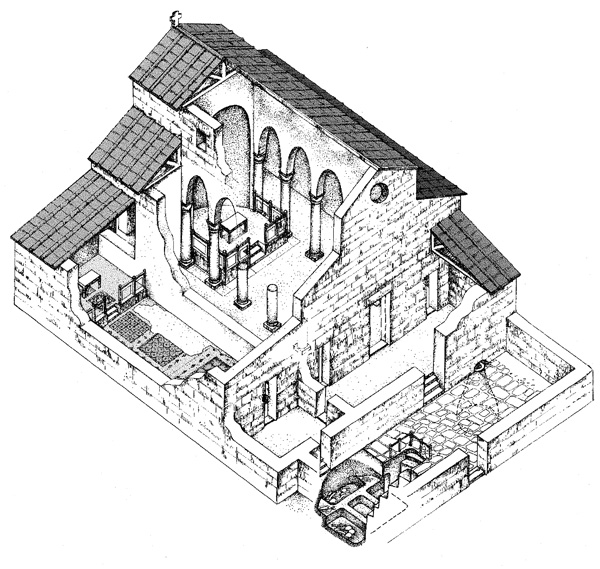
A basilical church with narthex and atrium was constructed in the southeastern part of the site. The nave and northern aisle were paved with colorful mosaics. The church had a single external apse; the bema was enclosed by a marble chancel screen. Two or three steps led from the nave to the bema. Other rooms belonging to the church were built to the north of the basilica. The lid of a marble reliquary was discovered in the church. In the atrium was found the fragment of a marble basin with a Greek inscription reading “For the sake of his salvation…,” and several fragments of decorated marble colonnettes belonging to an altar table or an ambo. On the steps leading from the atrium to the narthex lay a complete bronze incense burner.
In the middle of the atrium, under the stone pavement, was a hewn crypt––the only ever discovered beneath the atrium of a church in Israel. Six high steps led to a low opening that gave access to a rock-cut plastered room, 3 by 3 m, with arcosolia on three sides. The crypt contained the piled primary burials of more than 100 individuals. The upper parts of the bodies had been burnt. Among the bodies were found pottery lamps, three glass bottles, a glass thimble, and metal objects dating from the beginning of the seventh century CE.
The church, with minor alterations and additions, remained in use during the Umayyad period. At the beginning of that period the two rooms north of the northern aisle were joined together to form a chapel with a square apse (stratum IVa). The mosaic decorating the chapel’s bema contained a stylized cross; another smaller cross appears in the mosaic beneath the altar table.
The settlement’s economy was based on agriculture and related activities. A winepress and three olive-oil presses were found. The olive-oil press, which is situated west of the Hasmonean fortress, was preserved almost in its entirety. It consists of a crushing apparatus and two screw presses. The two stone weights were each more than 1 m in diameter and c. 1.4 m high. Adjoining this press, to the east, was a long room paved with a crude white mosaic, apparently a storeroom for storage jars full of oil. On the floor of this room were two plastered collecting vats. The olive-oil press continued in use in the Abassid period (stratum III).
Noteworthy finds from stratum IV include a fragment of a pottery vessel bearing a unique impression of a winged angel holding a cross, and two hoards of gold coins found hidden in small pottery jugs under the floor of the northwestern room of the site. The Christian inhabitants apparently feared an Arab attack, as most of the coins date to the reign of Heraclius, the Byzantine emperor who ruled the country on the eve of the Arab conquest.
STRATUM III. The settlement continued to exist and even flourish during stratum III, the Abbasid period, but underwent many changes. Rooms, courtyards, and streets were blocked and new buildings were constructed on the settlement periphery. The residential buildings of this stratum had domed roofs carried by four corner piers. At some point in the Abbasid period, the altar table in the chapel was removed and replaced by a small baptismal font. The church apparently went out of use only at the end of this period, when it was destroyed in a conflagration. The settlement was abandoned during the course of the tenth century CE.
STRATUM II. A sparse occupation was concentrated mainly in the center of the site during stratum II, the eleventh century CE. Doorways and passages were blocked and walls were constructed above the ruins. Tabuns were built on top of the walls and lime kilns were constructed at the edge of the site. The inscriptions on lamps and pottery vessels and the absence of pig bones among the animal remains of this stratum indicate that its inhabitants were Muslim. This settlement ended in the twelfth century.
STRATUM I. The surface of the site (stratum I) was damaged in the early 1960s during public works carried out by the Jewish National Fund. Heavy machinery destroyed the upper part of the site and damaged mosaics, walls, and floors.
UZI DAHARI, UZI ‘AD
INTRODUCTION
The site at bypass road 444, east of the modern town of Shoham, was not discovered during surveys of the area and does not appear on the Map of Lod for the Archaeological Survey of Israel. Its remains were exposed only when the area was being prepared for the construction of the road. It is situated on a shoulder of a gentle slope in the western hills of the Shephelah. A salvage excavation was carried out at the site by U. Dahari and U. ‘Ad, on behalf of the Israel Antiquities Authority, in 1995–1996. An area measuring 130 m by 75 m was excavated and seven occupational strata were identified.
No evidence was found for the ancient name of this large site. Four possible identifications of the site are proposed on historical-geographic grounds: (1) Neballat, a place mentioned in the Bible and in various historical sources, identified today with the ruins of the Arab village Beit Nabala, located about 1 km south of the site. (2) Zeboim, which is mentioned only in Nehemiah 11:34, where it is located between Hadid and Neballat. This identification is problematic because of the paucity of Persian period finds at the site in question, and its location north of Hadid and Neballat. (3) Betomelgezis, which appears only on the Medeba map as a place north of
