
Umm Deimnah, Khirbet
INTRODUCTION
Khirbet Umm Deimnah is located at 518 m above sea level in a hilly area where the southern Hebron Hills and the northern Negev meet, c. 5 km southwest of Dahariya and c. 2.5 km south of Khirbet ‘Anab el-Kebir. Remains are found in two areas at the site. On the hilltop to the east are remains of a monastery, agricultural installations, and dwelling caves. To the west, at the bottom of the hill, is a rectangular building, constructed of ashlars and covering an area of less than 0.25 a., with a central courtyard surrounded by rooms. There are several cisterns within and around the site.

The site is first mentioned by the Palestine Exploration Fund survey in the late nineteenth century. W. M. F. Petrie found two stone lintels decorated with crosses during a visit to the site. In 1938, the site’s name appeared in the survey published by P. Abel, who suggested identifying it with the biblical Madmannah (Jos. 15:31), which is mentioned in Eusebius’ Onomasticon. However, neither the findings from the two surveys nor the excavation support this identification. As part of a survey of Judea conducted following the Six-Day War, M. Kochavi examined remains on the hilltop, identifying them as a Roman villa. In 2004, the center of the site was excavated by Y. Magen and S. Batz on behalf of the Staff Officer for Archaeology in Judea and Samaria.
EXCAVATION RESULTS
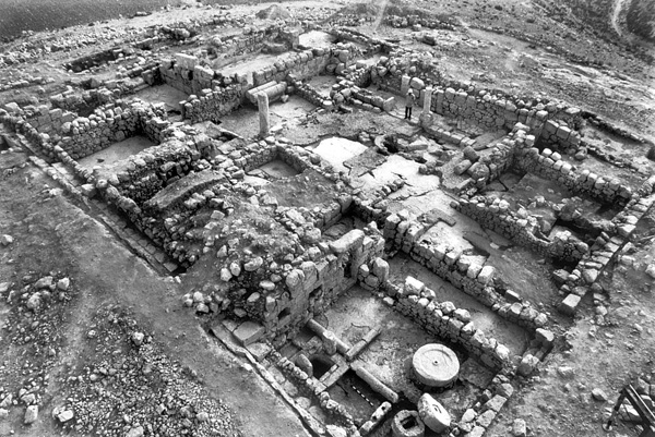
THE MANOR PHASE. The first and most important phase uncovered at the center of the site dates, based on finds and stratigraphy, to the fourth–sixth centuries CE. The site appears to have been occupied by a fortified manor house in this phase. The building was square (22 by 22 m) and consisted of a peristyle courtyard enclosed by three wings. It lay over a cave in its northwestern section. Its outer walls were preserved at least to foundation level, its western wall almost to its full height, due to buttresses that were added to it in a later period. All the outer walls were built of ashlars with protruding bosses. The main entrance to the house was through an opening in the northern wall; the southern wall was fitted with a postern.
The peristyle courtyard (9.5 by 9.3 m) in the center of the complex had a floor of pressed white clay, a cistern, and porticoes along its eastern and western sides. Four stylobates were found on the eastern side and two on the western. Each portico was 2.2 m wide and paved with the same pressed white clay floor found in the courtyard. In this initial phase, wings were constructed on all sides of the courtyard except the southern. The northern wing was excavated in full, while the eastern and western wings were only partially excavated.
The northern wing (24 by 7.5 m) included a hall (12.5 by 5.9 m) paved with pressed white clay. (This hall would later become the chapel of the monastery.) The hall was entered from the south and east. The main entry to the complex was uncovered to the west of the hall. It was shut using a sliding bar; 1.8 m of the track for the shutting mechanism was uncovered. The northern entry led to a closed space, either a gatehouse or a sheltered area at the gate. In this area were found the most massive walls at the site, raising the possibility that a watchtower stood at this northwestern corner of the complex.
Two openings led into the western wing from the western colonnade. The northwestern entry led into a storeroom, and the southwestern into a stable. The latter entry was particularly wide (1.8 m), probably so that horses could fit through when brought into the stable. The eastern wing consisted of various rooms, as based on the blocked doorways discovered in the eastern wall of the portico. Only the northernmost room of this eastern wing was excavated; it later served as the diaconicon of the monastery.
THE MONASTERY PHASE. In the second phase, a monastery was erected over the fortified manor house, making use of the house’s remains, with a number of changes and additions. South of the monastery was a winepress and other installations. This phase is dated to the beginning of the sixth century CE, based on analysis of the mosaic pavement of the monastery.
The courtyard was reduced in size (9.5 by 7 m), and new porticoes were installed in the north (12.5 by 3 m) and south (13.1 by 1.5 m). For this purpose, four new pillar bases were placed along the southern and northern edges of the courtyard, three of which were found in situ. The piers on the stylobates of the first phase were taken apart and reused in walls separating the courtyard from the eastern and western porticoes. The stylobates themselves were topped with stone pillars, apparently with capitals to support second-story galleries above the porticoes. The courtyard was paved in a white mosaic and fitted with a water drainage system consisting of inner and outer channels connected to a cistern east of the monastery.
A southern wing (24 by 5.5 m) was added. It contained four rooms and an entry corridor to the monastery; this main entry must have replaced the earlier opening in the northern wall, from the manor phase. The floors of the rooms were paved in coarse white mosaics. This annex housed various installations for the upkeep of the monastery.
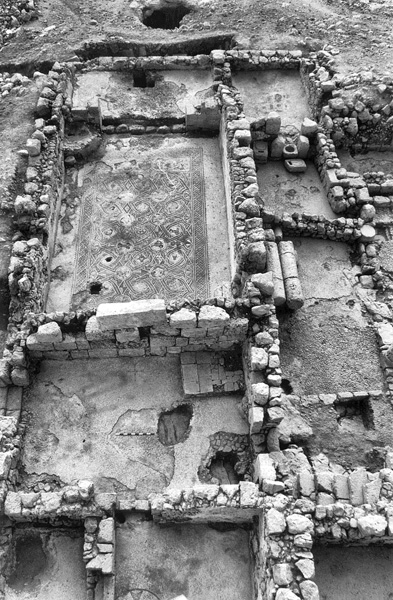
Several small changes were made to the western wing, including the laying of white mosaic floors. The northwestern gatehouse was transformed into the entrance room leading to the chapel. As mentioned, the northern section of the eastern wing was converted into the diaconicon, in which a colored mosaic pavement was laid. Within the northern wing, the chapel was founded within what had been the hall during the first phase. It contained a bema on its eastern side and a plastered baptismal font next to the bema wall. Two plastered niches were discovered in the northern wall of the chapel. The old openings of the original hall continued in use with minor changes. The entire chapel was carpeted in a colorful mosaic floor with an inscription in front of the bema.
The chapel mosaics include colorful images of animals and plants, as well as geometric motifs. The animal images were ruined during the iconoclastic movement of the early eighth century CE, apparently by the Christians themselves, who wanted to conform to the Muslim authorities’ edict regarding this matter. The original mosaic included a pair of lions in heraldic poses on both sides of stylized amphorae, and several winged creatures inhabiting medallions. The medallions also contained plant motifs and perhaps even the image of a basket with bread loaves, reminiscent of Jesus’ miracle of the loaves. On the bema was a mosaic with geometric decorations; at its center, an inscription of which only a few letters have survived. Two panels of polychrome mosaics were found in the diaconicon, the western panel depicting an amphora with emanating vines, the eastern schematic fish, not destroyed by the iconoclasts. The mosaic pavement west of the chapel, facing its entrance, contained two stylized, colored crosses.
During the Early Islamic period, several minor changes were made to the monastery, including the disfiguring of the images in the chapel mosaic, the installing of an immersion pool in the chapel, and the conversion of several rooms into storerooms. The monastery ceased to exist at the end of the eighth century CE.
THE POST-MONASTERY PHASE. The third phase of the structure, also dated to the Early Islamic period, belongs to the period after the monastery went out of use, when major alterations to the building were carried out. A northern wing, which included several rooms with industrial installations, was added. One such installation had running water. Several walls were added to the monastery building, running across the mosaics from the earlier phase and eliminating the northern and western porticoes. In the southern wing, an olive-oil press was added, making use of some of the chapel’s liturgical furniture. A smaller olive-oil press was discovered at the entrance to the now-blocked diaconicon. Several new floors and a staircase to the second floor were also added. The site was entirely deserted after the ninth century CE.
YITZHAK MAGEN, SHAHAR BATZ