
A Sea Change? Finding the Biblical Red Sea
Where was the biblical Red Sea?1
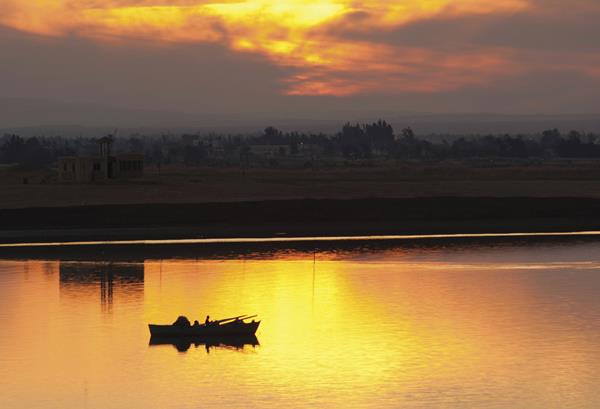
This sea—yam suf in Hebrew, which literally means “sea of reeds”—features prominently in the Exodus tradition: Moses stretches out his hand, God parts the sea, and the Israelites cross on dry ground—a miraculous escape from the advancing Egyptian army (Exodus 14). But where did the biblical writers believe this crossing took place?
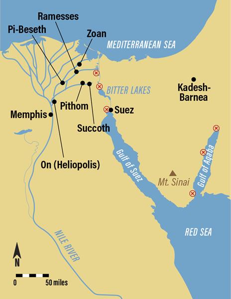
The primary view places the crossing close to Egypt’s eastern border, either at the northernmost segment of the Gulf of Suez or perhaps more preferably at one of the ancient marsh-like reedy lakes that separated easternmost Egypt and Sinai (see map). This longstanding and widespread view is rooted in both Jewish and Christian texts from the medieval period and earlier, in early Jewish and Christian maps (some of which date to the 13th century), and in early Christian pilgrimage accounts (going back to the very first pilgrimage record of Egeria, an aristocratic woman from Spain, in c. 382 C.E.).a
A second, more recent view equates the Red (or Reed) Sea—in all 26 of its biblical citations, without exception—with the modern Gulf of Aqaba (or Gulf of Eilat). It situates the Exodus crossing more than 250 miles from Egypt’s Delta. This interpretation jettisons established scholarship and the early sources alike.2
A precise geographical placement of the tradition of the Exodus crossing is complicated by several factors, including the massive upheaval of terrain occasioned by the Suez Canal’s construction in the 19th century and the possible shifting sea level across this lowland through antiquity. Another consideration is the biblical expression yam suf. Although it is uniformly employed to identify the event of the Exodus tradition, it also appears in biblical contexts that have nothing to do with the Exodus and, therefore, may not offer direct testimony to the precise placement of that event within the biblical tradition.
For example, Solomon is said to have undertaken a naval adventure to the land of Ophir by constructing a fleet of ships at the site of Ezion-Geber, on the shore of yam suf (1 Kings 9:26), which, in context, must identify the modern Gulf of Aqaba.b On the other hand, Yahweh is said to have used a west wind to drive a plague of unwanted locusts from Egypt into yam suf (Exodus 10:19), which logically references one of the marshy lakes east of Egypt. Finally, we learn that the Israelites—having been delivered at yam suf (Exodus 15:22; Numbers 33:8) and then proceeding farther along their journey—are subsequently said to have “made camp” beside yam suf (Numbers 33:10-11). In any scenario (other than a round trip), this must designate a different location than the exact point of the Exodus crossing and, quite likely, a location along the eastern coastal plain of the modern Gulf of Suez, as the story’s authors wrote that the Israelites were en route to Mt. Sinai at the time.
Whatever the case, to assert that yam suf, in all its biblical citations, must designate only one specific and precise piece of geography strains credulity to a breaking point. Accordingly, standard reference tools, scholarly monographs, and commentary literature almost unanimously construe yam suf to reference either (1) the Gulf of Aqaba, (2) the Gulf of Suez, or (3) one of the inland marshy lakes separating Egypt and the Sinai—depending on context.
The notion of a biblical toponym referencing multiple locations has long been recognized as axiomatic in the discipline of historical geography, and it is by no means unique or unusual with yam suf. This kind of homonymy normally occurs because biblical place names tend to be generic in meaning, often composed of a common geographical, spatial, or divine element.
For example, Bethel means “a house of God,” Gibeah “a hill,” Gilgal “a circle (of stones),” Socoh “a thorny place,” Ain (or En) “a spring,” Migdal (or Migdol) “a tower (or fortress),” Ramah “a hill (or high place),” and so forth. It is not surprising that these geographical names—and arguably 150–200 more in the Bible—are each used to designate more than one location. There appear to be as many as seven different locations named Kadesh (or Kedesh, “a sanctuary”), five distinct locations named Mizpah (“a watchtower”), and four separate locations named Aphek (“a fortress”). This sort of homonymy is not limited to the Bible. Egyptian and Assyrian literature, for example, attests to at least seven different sites in Canaan known as Abel (“a meadow or grazing spot”).3
Beyond the varied use of yam suf in the Hebrew Bible, a similar homonymy also appears in early Greek and Latin translations of the biblical text, the third-century B.C.E. Septuagint and the fourth-century C.E. Vulgate, respectively. In the Septuagint, yam suf is translated as erythra thalassa (“Red Sea”); its Latin equivalent is mare rubrum. Erythra thalassa and mare rubrum appear more than 800 times in classical literature as a homonym referencing any one of seven distinct bodies of water: the Bay of Bengal, Indian Ocean, Persian Gulf, Gulf of Aden, Gulf of Arabia (modern Red Sea), Gulf of Heroonpolis (Gulf of Suez), and Gulf of Aelanites (Gulf of Aqaba). Sometimes it simply references nearby water. The pattern of homonymy with Hebrew yam suf—and the way that expression was conceptually understood—was naturally carried forward into the classical era.
Given this historical and cultural context, the biblical Red Sea should not be identified exclusively with the Gulf of Aqaba. Readers and scholars alike need to take cues from the biblical text to understand the sea’s identity and location on a case-by-case basis. Although it may never be known exactly where the biblical writers understood the Exodus crossing to have taken place, it is better situated on Egypt’s eastern border—either at the Gulf of Suez or one of the reedy lakes that separated Egypt from Sinai. This traditional interpretation remains the best.
Please join the BAS Library or become an All Access member of BAS to gain full access to this article and so much more.
MLA Citation
Footnotes
1. See Robert L. Wilken, “The Holy Land in Christian Imagination,” Bible Review, April 1993.
2. Gary D. Pratico, “Where Is Ezion-Geber? A Reappraisal of the Site Archaeologist Nelson Glueck Identified as King Solomon’s Red Sea Port,” BAR, September/October 1986.
Endnotes
1.
This piece grows out of my recent publication, Where Was the Biblical Red Sea? Examining the Ancient Evidence (Bellingham, WA: Lexham Press, 2020). In that volume, I provide exegetical, geographical, classical, and early cartographical evidence to undergird the traditional identification of the Red Sea.