

The Bible mentions the Jordan River more frequently than any other geographical feature—181 times in the Hebrew Scriptures and 15 times in the New Testament. The Bible speaks of this side of the Jordan, that side of the Jordan, beyond the Jordan, over the Jordan. Yet, when actually crossing the Jordan, no psalmist ever paused, even for a moment, to praise its waters. When the exiled Jews wept by the rivers of Babylon, they did not yearn to see their native river; rather they remembered the city of Jerusalem (Psalm 137).
The Jordan was not a river to be loved. It was a barrier to be crossed: “and they went down after him, and took the fords of the Jordan toward Moab, and allowed not a man to pass over” (Judges 3:28). Or, the Jordan was a natural boundary: “and the boundary shall go down to the Jordan” (Numbers 34:12).
Outcasts and fugitives crossed the Jordan. Elijah the prophet hid by the Jordan: “Get thee hence, and turn eastward, and hide by the brook Cherith, over the Jordan” (1 Kings 17:3). King David, fleeing from his son Absalom, sought refuge across the Jordan: “Then David arose, and all the people that were with him, and they passed over the Jordan: by the morning light there lacked not one of them that was not gone over the Jordan” (2 Samuel 17:22).
Occasionally the crossing of the Jordan took on a spiritual significance, perhaps never more poignantly than in these final words to Moses before his death:
“Get thee up to the top of Pisgah, and lift up thine eyes westward, and northward, and southward, and eastward, and behold it with thine eyes: for thou shalt not go over the Jordan” (Deuteronomy 3:27).
In the New Testament the Jordan is associated with crossing over to a new life of spiritual freedom, symbolized by baptism: “And it came to pass in those days, that Jesus came from Nazareth of Galilee, and was baptized of John in the Jordan” (Mark 1:9).
The Jordan’s importance in the Bible is not matched by its physical dimensions. Mark Twain, a greatly disappointed traveler in the Holy Land, had this to say:
“When I was a boy I somehow got the impression that the river Jordan was four thousand miles long and thirty-five miles wide. It is only ninety miles long…[and] not any wider than Broadway in New York.”1
From the Jordan’s headwaters at Mt. Hermon (elevation, 9,233 feet) to its terminus at the Dead Sea (about 1,312 feet below sea level) the distance, as the crow flies, is about 90 miles. However, to get to the Dead Sea, the Jordan twists back and forth and actually flows over a 200-mile course (the distance from New York to Baltimore). As rivers go, this is a relatively short distance. The Euphrates flows for about 1,700 miles (New York to Denver), and the Nile flows for about 4,145 miles (New York to San Francisco and back again to Denver), both over comparatively direct routes from mountains to the sea.
Water-discharge statistics offer another physical comparison. The Jordan, in the years before large amounts of its water were diverted, used to deliver annually an average of about 1 billion cubic meters (35 billion cubic feet) of water to the Dead Sea. The Pyramid of Khufu, near modern Cairo, has an estimated volume of 2.5 million cubic meters (base, 13 acres; height, 450 feet). So, with a little arithmetic, one can say that the Jordan discharged into the Dead Sea an average of a little more than one gigantic Egyptian pyramid of water per day. This may seem like a lot of water, but not when compared with the 32 billion cubic meters of the Euphrates (in central Iraq), or the 84 billion cubic meters of the Nile (at Aswan).2
Any physical match between the Jordan and the Euphrates or the Nile is no contest. Yet, the Bible does make such an incongruous comparison. In biblical times an experienced traveler would have recognized the sarcasm in this scriptural reference. A reader of today, however, may need to know more about these rivers.
The reference concerns the parting of Abraham and Lot. To avoid further strife between their herdsmen over scarce pasture land, Abraham suggested that he and Lot go their separate ways. Abraham generously offered Lot a first choice of land: “if you take to the left, then I will go to the right; or if you will take to the right, I will go to the left” (Genesis 13:9).
Lot lifted up his eyes. From where he was standing, on an overlook near Bethel, Lot could see the nearby rugged hills of Canaan to the west. To the east, down below, he could see the fertile plain of the Jordan. The plain “was well watered everywhere…like the garden of the Lord [the valley of the Tigris and Euphrates], like the land of Egypt [the valley of the Nile]” (Genesis 13:10). Lot apparently never hesitated. Based on outward appearance the “well watered” plain of the Jordan seemed the better deal.

And what did Lot gain from this bargain? He was soon captured, and his goods were stolen by Chedorlaomer. Later the men of Sodom tried to break into his house and abuse Lot’s guests. Finally, Lot and his family narrowly escaped total destruction when fire and brimstonea destroyed the cities in the valley (Genesis 19:24–25).
The Jordan was “well watered,” to be sure, but appearances can be misleading. The waters would not have been of much use to Lot or to his flocks. Greed motivated his hasty decision, and the Jordan would only frustrate his ambitions. The adjacent area is unfit for agriculture; no cities are known ever to have located close to its banks.3 From the overlooking hills, however, the dense green thicket of shrubs and trees watered by the Jordan (especially against the background of desert) must have appeared to Lot as lush and potentially prosperous. But this vegetation actually had no value, other than as a minor source of wood (2 Kings 6:4). In biblical times, and even today, the banks of the Jordan were places to avoid or to go over as quickly as possible.4

The valley of the Jordan is not a river valley, the floor is not a floodplain, and the river is of so little value (in a land where water is treasured) that there are no physiographic terms in the Hebrew language adequate for description. Thus it is not really so surprising that the Hebrew Scriptures never use the word “river” (nhr) with the Jordan, nor the word “valley” (emek), nor the word “plain” (bekah) for the adjacent area. The landscape in which the river is found is so singular that a special name was needed: The Jordan.
The Jordan Valley was not carved out, as most valleys are, by erosion caused by water. It formed as a tectonic rift, or trough, in the earth’s surface, caused by the movement of two tectonic plates.b The Arabian plate to the east slid laterally northward (about 60 miles) against the African plate, and then veered off slightly eastward. The eastward movement pulled apart the crust to form a rift valley some two to fifteen miles wide.
During the last glacial period, rainfall was more abundant in this region than it is now. Runoff filled the rift valley with fresh water to form a lake ranging between three and fourteen miles wide and extending from the Dead Sea to the Sea of Galilee (Lake Kinneret). This lake began to recede when rainfall diminished, beginning, perhaps, some 25,000 years ago. Unlike other valleys, the floor of the Jordan rift was formed mainly from dried-up lake sediment, rather than from river sediment. The Jordan River is not only younger than the valley floor, but also younger than most of the tributaries that now flow into it.5 The lower Jordan River may have assumed its present form at about the same time that man first settled the ancient site of Jericho, some 14,000 years ago.
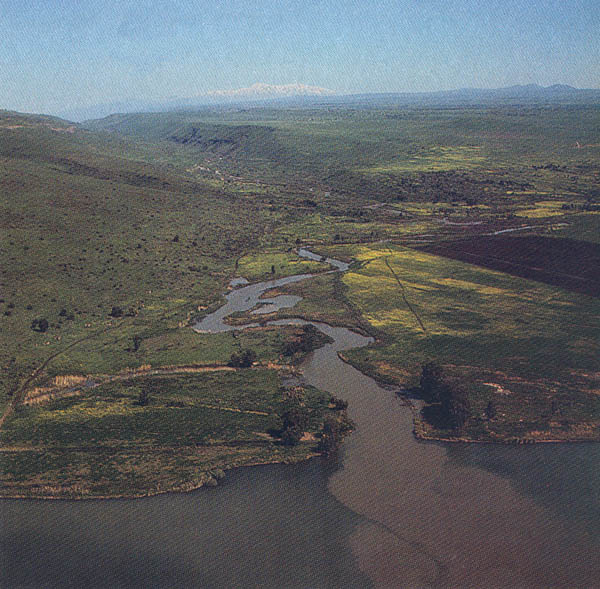
When Abraham and Lot looked down from the hills of Ephraim near Bethel into this rift, about 4,000 feet below, what they saw was a physical feature unlike anything else they had ever seen. The sides of the rift descend suddenly and precipitously and then almost level out, forming a shape like a letter U, except that the width of the plain at the bottom is five to fifteen times the height of the sides. The lacustrine (lake-formed) plain of the valley floor is, for the most part, arid, intricately gullied and virtually devoid of vegetation. The soil, which is almost impermeable to water, sheds the occasional winter rain and erodes easily. As the sediment washes away, the plain takes on an intricate and bewildering pattern of rills, ridges, tiny mesas and buttes. The soil on these badlandsc is too saline for most vegetation, although on upper terraces, where freshwater springs can be found, irrigation from the springs can wash out excess salts and support local agriculture. The Bible called the entire valley floor the kikar ha yarden, “the environs of the Jordan.”
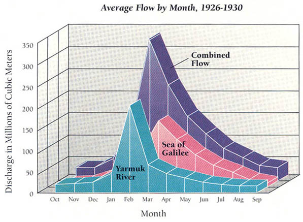
Monthly Discharge of the Lower Jordan
Most of the valley floor is colored ash-gray. The crusty soil crunches under foot into a clay powder. These fine clay particles, when moist, adhere and can be shaped and hardened into molds. The brass vessels of the First Temple were cast in this soil: “In the valley floor of the Jordan did the king cast them in the clay ground between Succoth and Zarethan” (1 Kings 7:46).
To 19th-century travelers, however, this ashlike soil suggested fallout from the burned sodomite cities, a confirmation of the biblical text:
“all its soil devastated by sulfur and salt, beyond sowing and producing, no grass growing in it, Just like the upheaval of Sodom and Gomorrah, Admah, and Zeboiim, which the Lord overthrew in his fierce anger” (Deuteronomy 29:23).
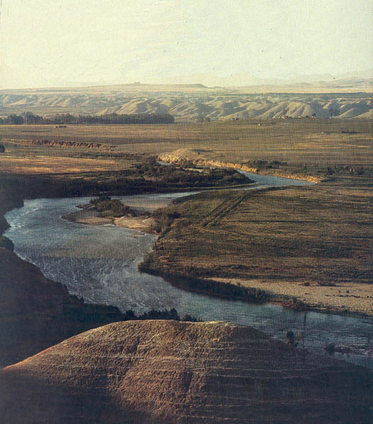
These “bad lands” lie from 50 to 150 feet above the river and narrow floodplain that traverses the center of the valley floor, a height that sometimes prevents the river from being seen from the badlands. Normally the river, referred to as may ha yarden (literally the “waters of the Jordan”), is not more than 300 feet wide and in some places is as narrow as 55 feet. It twists to the east, and then to the west, and back again. This meandering of the Jordan broadens the floodplain, which, nevertheless, is rarely more than a mile wide.
Most of the year the river is scarcely a few feet deep and can be forded easily in number of places. In the late winter and spring, however, the Jordan rises and overflows the willows, tamarisks, poplars and acacias on its floodplain. Among these trees also grow a tangle of bushes, vines and shoulder-high thorns and thistles, a dense, tropical, dark-green thicket that presents a striking contrast to the ash-gray of the valley floor. This narrow, uninviting floodplain was known as the geon ha yarden (the thickets of the Jordan). Trying to make headway through this swampy entanglement became a byword for trouble and complexity: “If you fall headlong in easy country, how will you fare in the Jordan’s dense thickets?”(Jeremiah 12:5).
This environment was a fit habitat only for venomous snakes, jackals, wild boars, a variety of rats and ravenous lions: “Behold, like a lion coming up from the Jordan’s dense thickets…I will, in a sudden moment, put them to chase …” (Jeremiah 49:19, 50:44).
The Jordan is the only stream in Israel, or modern Jordan, with major tributaries. It can be divided into an upper and a lower portion.
The upper Jordan flows southward about 25 miles to the Sea of Galilee from its headwaters: the Snir, the Dan and the Banias. These sources are fed by precipitation on Mt. Hermon. Water enters into the tributaries either directly as runoff or, indirectly, from scores of springs that gush out from the sides of the porous limestone mountain. These tributaries join to form the Jordan River near the base of Mt. Hermon. From here the Jordan used to flow into a small, swampy, malarial lake called the Huleh (not mentioned in the Bible and drained almost entirely during the 1950s). The Jordan then runs swiftly down to the Sea of Galilee, plunging almost 900 feet in ten miles, mainly through a narrow gorge. These features provide the imagery for one of the Bible’s rare references to the upper Jordan:
“Therefore will I remember thee, from Hermon’s peaks and the land of Jordan…as deep calls to deep with the roar of cascading waters …” (Psalms 42:6–7; verses 7–8 in Hebrew).
When the Bible speaks of the Jordan, however, It usually refers to the lower Jordan, the section below the Sea of Galilee. The lower Jordan pours out of the Sea of Galilee into a valley that is about 65 miles long. The Jordan terminates at the Dead Sea; it has no outlet to the ocean. Upstream from the Dead Sea, two major tributaries join the lower Jordan on the east: the Jabbok (Genesis 32:22; verse 23 in Hebrew), which joins almost halfway up the lower Jordan, and the Yarmuk (not mentioned in the Bible), which enters just below the Sea of Galilee. The Yarmuk, the largest of the tributaries, strongly affects the seasonal flooding of the Jordan.
The time of flooding of the Jordan helps to explain why it was useless for agriculture. As the chart (above) shows, the winter rains bring large quantities of water into the Sea of Galilee. The lake at the start of this period is generally low because of the long dry summer and fall. The maximum discharge from the lake occurs in early spring (March and April) when the melting snows from Mt. Hermon add still more water to the high level created by the winter rains. The Yarmuk River, however, tends to peak earlier, in February, during the winter rains in Gilead, the region to the east of the Jordan. The two peak flows are slightly staggered in time, which tends to prolong a high flow for the Jordan throughout the late winter and early spring. In some years a violent cloudburst over Gilead at the end of the rainy season in March will bring downpours of as much as 2 inches in an hour and with it the Yarmuk’s sudden gushing to more than 30 times its normal flow. If these discharges occur when the lake is also high, the floods in the valley can have extraordinary force.
Witnesses to such floods have seen poplars and tamarisks covered almost to their tops by turbid waters. After the waters recede, the floodplain is left coated with slimy mud and littered with the fallen trunks of uprooted trees.
During flooding the Jordan carries large quantities of sediment eroded from its own banks and also receives soft marls eroded from the badlands. The force of the flood may cause the Jordan to swirl and shift, abandoning one channel and cutting another. The scar of the abandoned channel will quickly heal with muds that are left behind.
Although only 65 miles separate the lower Jordan’s outlet at the southern end of the Sea of Galilee and its mouth at the northern end of the Dead Sea, the river actually travels 135 miles along a winding path.d The twisting of the river obstructs travel, both in the water and along its banks. (Mark Twain described the Jordan as “so crooked that a man does not know which side of it he is on half the time.”)

If the lower Jordan did not meander, then its fall as it flows southward would be more sudden—about 9 feet per mile. Meandering, like switchbacks on a mountain road, reduces that gradient by about half. The gradient is still relatively steep for a mature river, and it produces swift dangerous currents that have been measured at averages of 5.5 feet per second. The force of such current at waist level can, and does, drown people caught in its waters.e Only a Behemoth or a Leviathan would feel comfortable with such an awesome display of natural force:
“Only he is not afraid of the flooding Jordan; he rolls at ease as the waters rush against his mouth.”
Job 40:23
Where the river abuts the badlands, the banks may rise 50 to 150 feet above the water. From these banks, huge slabs of earth may suddenly break away and fall into the river, temporarily damming its flow. The detachment may be triggered by an earthquake:
“The mountains skipped like rams;
the hills like young lambs.
What ails you …?
O Jordan, that you turn back?”
Psalm 114:4–5
Such occurences have been recorded in post-biblical times. In 1267 the Jordan was stopped for eight hours, in 1546 for two whole days and in 1927 for 21.5 hours.6 Witnesses must have been astonished. To see the powerful flow of the Jordan turn back had to be an unforgettable experience. Talk about it would spread throughout the land, and one generation would tell another. To the people of the Bible, it was a miracle that Joshua could cross in the midst of the Jordan on dry land, but it was not at all inconceivable:
“And when the soles of the feet of the priests who bear the ark…shall rest in the waters of the Jordan, the water of the Jordan shall be stopped from flowing…And while all Israel were passing over on dry ground, the priests who bore the ark of the covenant of the Lord stood on dry ground in the midst of the Jordan until all the nation finished passing over the Jordan” (Joshua 3:13, 17).
The Jordan River was never put to agricultural use in biblical times. The thickets were not cut down; the fertile soil near the river went uncultivated.
How different was the Jordan from the Euphrates and the Nile? The Euphrates and Nile valleys supported vast areas of irrigated agriculture that provided the basis for major civilizations. Israel, on the other hand, depended almost entirely on seasonal and unpredictable rainfall. Irrigation was used locally, as at the oasis of Jericho, but nowhere on a scale comparable to the two great hydraulic civilizations.
Egypt provides the simplest example of a hydraulic civilization. The Nile overflows its banks every year from about August to November. The waters rise 15 to 25 feet above normal and are delivered over a plain that is three to seven miles wide. The waters leave behind a moist soil and about a half-inch of fertile silt. In the late autumn the peasants planted wheat (for bread), barley (for beer) and flax (for linen cloth). These crops grew for several months during the winter before the soil dried out. The crops were harvested in the spring. The Nile also provided excellent transportation, helping to unify Egypt. Throughout most of the year, a moderate current could move boats downstream toward the Delta. The same boats could then set their sails and return upstream pushed by the dominant northeast trade winds.
The people of Mesopotamia had a more complex river agriculture. The Tigris and Euphrates flood irregularly in the spring, requiring dikes to prevent water from overflowing fields where crops are still growing. The famous Hammurabi Code stipulated that if a man’s dike broke and flooded his neighbor’s farm he had to repay the damage in wheat or go into slavery. Canals were also dug to divert the floodwater and distribute it. The Mesopotamian Valley is much broader than the Nile Valley, and the area for potential water distribution is vast. The water was stored in canals for use in irrigation during the autumn, when seeds were sown.
River systems requiring water management and providing transportation, such as in Egypt and Mesopotamia, encouraged the development of centralized government to record and manage the distribution of water. Bureaucratic systems based on river management become experienced at record keeping and also enjoy a prosperity that enables them to create large armies. A state system of intelligence based on swift transportation along the river can compel service and taxation. The individual in such a society, when it becomes despotic, may be at the mercy of a king demanding compliance.7 In contrast, an agricultural economy primarily based on rainfall—not irrigation—such as that of Israel, did not require or achieve highly centralized control.
The Jordan was never used for water transportation or for agriculture. The meandering of the river, the extreme variations in its flow and its dense thickets discouraged travel in the river or along its banks. Roads were carved out for north-south valley travel, but they were located well above the floodplain and were used only for local transportation.
In biblical times, the technology simply did not exist to utilize the waters of the Jordan for agriculture. Unlike the Euphrates, the floodplain of the Jordan was much too narrow for water diversion and storage in canals. Any canal would have been overwhelmed in a flood. Furthermore, the Jordan River was incised too deeply into the valley floor. No mechanism existed in biblical times for raising water to high levels where it might be used for irrigation.
The Jordan has a fertile floodplain zone, but unlike the Nile, which flooded at the right time—in the late summer and early autumn—the Jordan flooded at the wrong time—during the late winter and early spring: “the Jordan overflows all its banks throughout the time of harvest” (Joshua 3:15).
Had the Jordan turned toward the Mediterranean down the Jezreel valley (as it apparently once did during its geological history) rather than to the Dead Sea, it would have been like many other rivers in the ancient world: a waterway supporting lively commerce and densely cultivated agriculture. Since history does not allow us to conduct controlled experiments, there is no way of knowing how a different sort of Jordan River might have affected the course of biblical events. But physical setting is important.
The Jordan, therefore, can be appreciated both for what it was and what it was not. It was not a river surrounded by prosperous agricultural land that could provide an environmental and economic basis for a centralized government. Rather, it was a river that served as a natural boundary to separate and differentiate lands. This natural boundary was not absolute; it could be crossed, but the crossing required some effort and some sense of physical, and perhaps spiritual, transition.
Please join the BAS Library or become an All Access member of BAS to gain full access to this article and so much more.
MLA Citation
Footnotes
See
See “Have Sodom and Gomorrah Been Found?” BAR 06:05.
See the following articles in BAR: Adam Zertal, “Has Joshua’s Altar Been Found on Mt. Ebal?” BAR 11:01; Aharon Kempinski, “Joshua’s Altar—An Iron Age I Watchtower” BAR 12:01; Zertal, “How can Kempinski Be so Wrong!” BAR 12:01.
Endnotes
Genesis 14:3; Numbers 34:3, 12; Deuteronomy 3:17; Joshua 3:16, 12:3, 15:2, 5, 18:19. It is also called
For additional information, see Atlas of Israel, 3rd ed. (Tel Aviv: Survey of Israel, 1985), pp. 14–15.
Josephus, The Jewish War 4.8.4; cf. Pilgrim of Bordeaux, annotated edition of P. Wesseling, Vetera Romanorum Itinera (Amsterdam: Wetstenium & Smith, 1735); cf. John Wilkinson, Egeria’s Travels to the Holy Land (Jerusalem: Ariel, 1981), pp. 161–163.