
Image Details
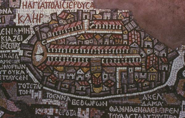
Part of the Madaba map, showing Jerusalem in an oval. The broad street in the center of the map is the Cardo. It extends from the Damascus gate on the north to the southern side of the city. On either side of the street is a handsome and carefully depicted colonnaded portico. The lower, or western, portico is interrupted by a building which, together with the Cardo, dominates the map. The building is the Church of the Holy Sepulchre as it appeared at the time. Reading from top to bottom, we see the following elements in the Church structure: Four steps which lead up to the facade of the basilica; in the facade can be seen three doors, a large center door and a smaller door on either side. The facade is topped by a triangular pediment. Below the pediment is the sloping tiled roof pictured in red and orange. Below this a single row of cubes marks the courtyard between the basilica and the rotunda. In the courtyard was the traditional site of Calvary. The church ends in a golden dome which stood over the tomb of Jesus. The principal east-west thoroughfare (the Decumannus) may be seen to the right (south) of the Church of the Holy Sepulchre. The Decumannus begins at an arched gate and is interrupted by the Cardo. The street which continues on the right is not the Decumannus, but another street which still exists in the same location today known as Armenian Street. Thirty-five other buildings are depicted within the city walls. For the most part, red roofs indicate churches or monasteries; yellow or gray roofs, palaces; and brown areas, public squares.