
Image Details
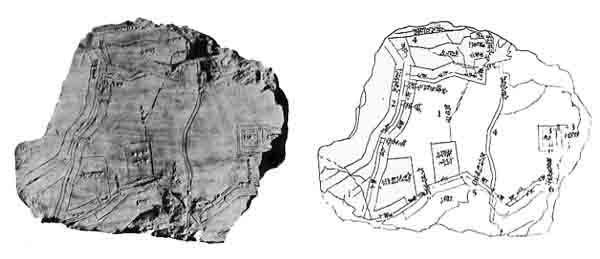
Drawing by Inez Bernhardt, from The Tablets of Sumer by S. N. Kramer/Photograph courtesy University of Pennsylvania Museum
The drawing shows many details of this map: the name of the city (1), the Euphrates River (2), temples (3), canals (4), the Erech (Uruk) gate (5), the Ur gate (6). Ur is given as Abraham’s birthplace in the Bible. Whether the Ur gate on this map refers to the same Ur is a matter of scholarly debate. The Ur named in the map is about 100 miles southeast of Nippur, which in turn is about 100 miles south of Baghdad. Erech is also mentioned in the Bible (Genesis 10:10); it is southeast of Ur. Assuming that these gates led directly toward their namesakes, archaeologists conclude that the top of this map was oriented approximately 45° west of north.
The legends on this map are written in Sumerian and Akkadian.