
Image Details
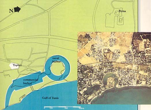
“The harbors had communication with each other, and a common entrance from the sea 70 feet wide, which could be closed with iron chains. The first port was for merchant vessels, and here were collected all kinds of ships’ tackles. Within the second port was an island which, together with the port itself, was enclosed by high embankments. These embankments were full of shipyards which had capacity for 220 vessels … On the island was built the admiral’s house, from which the trumpeter gave signals, the herald delivered orders, and the admiral himself overlooked everything.”
But today, as the aerial photograph (inset) of modern Carthage shows, only two small stagnant lagoons remain from these once great ports. The authors’ recent excavations in the commercial harbor and British excavations in the military harbor have dramatically confirmed Appian’s account. As reflected in Punic Carthage, the Phoenicians’ reputation as a major maritime power, both commercial and military, was well-founded.
It is ironic that, during the years when these beautiful harbors were being constructed and Carthage’s commercial and political domains were expanding widely in the fourth and third centuries B.C., the number of children sacrificed in the Tophet reached its peak.