
Image Details
British School of Archaeology in Jerusalem
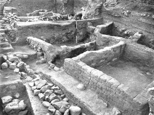
Signs of destruction from the final phase of City IV betray the calamity that befell Jericho. “The destruction was complete,” wrote Kathleen Kenyon, the area’s excavator. She discovered a debris layer a yard or more thick across her entire excavation area. This debris is visible in the west balk behind the meter stick in the photo (a balk is a side of an excavation square left standing to preserve a record of the square’s strata). The destruction debris has been removed elsewhere to expose the remains of the destroyed city. At the top of the north balk, upper right corner in the photo, is an erosion layer consisting of material washed down from further up the slope. Within the destruction debris of the north balk, we can see the remains of a late-14th-century B.C.E. structure. At upper left is a cobbled, stepped street (see close-up). The line of stones that extends from the center left edge of the larger photo to the center bottom is a drain that passed under the street preserved at upper left. The drain was originally covered with stones, but the channel of the drain is exposed here in the upper part. The street led from the summit of the city’s southeast slope to the spring on the east side of the city, which today fills the modern reservoir.