Image Details

Garo Nalbandian
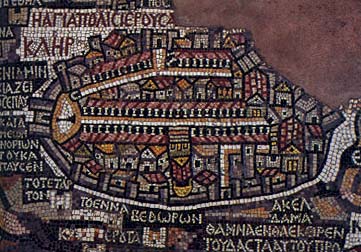
“The holy city of Jerusalem” reads the Greek inscription in the upper left corner of this sixth-century map, part of a mosaic floor from a church in Madaba, Jordan. The map shows Jerusalem as a large walled city, oval in plan and protected by 19 towers. East, rather than north, is on top in the map. White tiles demarcate the city’s main streets, including the column-lined Cardo, which cuts across the city from the Damascus Gate (at left) in the north to the Nea Church in the south. The plan includes 11 churches, identified by their red roofs. The Church of the Holy Sepulchre appears upside down at the center of the Cardo. See detail.
