
Image Details
Kenneth Nebenzahl from Maps of the Holy Land New York: Abbeville Press, 1986
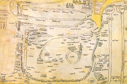
The Roman World, from Britain to Ceylon, appears in a 16th-century copy by Abraham Ortelius of a fifth-century road map that shows the land by way of milestones and sites, marking the way stations and major cities. A 12th-century copy of Jerome’s fourth-century map runs from Constantinople to Alexandria, and from the Mediterranean to the Ganges. Jerusalem stands in the center right, depicted as a circular wall with four gates.