
Image Details
Uppsala University Library, Sweden
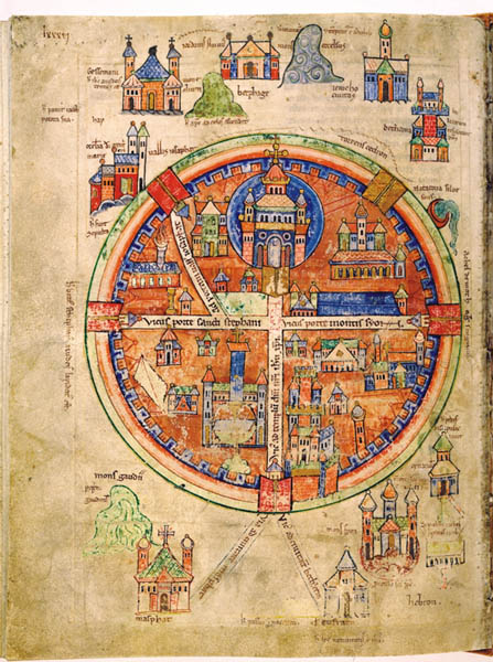
THE HOLY LAND OF THE CRUSADES. This 12th-century illuminated map provides a stylized rendering of medieval Jerusalem and its environs. The map is oriented toward the east and renders Jerusalem as a circle inscribed with a cruciform.
Jerusalem is protected by a fortified wall with five imposing gates. Within the walls, the city’s major thoroughfares intersect just below the gate to the Temple Mount. Crusader kings transformed the Dome of the Rock into a church crowned with a cross and al-Aqsa Mosque into a palace, which they called Solomon’s Palace. In addition, the map shows the dominating façade and lofty spires of the Church of the Holy Sepulchre and the towering, heavily fortified Citadel of David.
Pictured are various sites outside the city, including Gethsemane, the Mount of Olives, Bethany, Jericho and even the place where Jesus ascended to heaven. Below the city is the Cenaculum where the Last Supper took place. Especially significant to this article is —the mountain of Mons Gaudii (Montjoie) and its church, Masphat. The road connecting these sites to Jerusalem is labeled Via ad civitatem Masphat, or “the road to the city of Masphat.” “Masphat” is the Latin form of “Mizpah,” so this is a clear indication that the Crusaders identified the hill of Mons Gaudii as Biblical Mizpah.