
Image Details
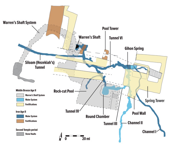
TONS OF TUNNELS. This complicated-looking plan (by Ronny Reich and Eli Shukron) of the area around the Gihon Spring is the key to understanding the maze of tunnels and other features that made up Jerusalem’s earliest water systems. The Gihon Spring is located near the upper right of the plan and was protected by fortifications as early as the Middle Bronze Age II (shown in yellow on the plan). During this period (marked in light blue on the plan) the Gihon’s water flowed south along the Kidron Valley via Channel II, as well as to the deep Round Chamber (via Tunnel III) that was carved into the northeast corner of the Rock-cut Pool’s floor.
Later, in the Iron Age II (noted as dark blue on the plan), they say that Tunnel IV was dug, starting in the Round Chamber and heading northwest toward what would then become the start of Hezekiah’s Tunnel (i.e., the Siloam Tunnel). Only after Hezekiah’s Tunnel had been carved the full distance to the Siloam Pool (not shown on the plan), with the teams meeting successfully in the middle, did the workers finally carve Tunnel VI eastward from Tunnel IV to connect Hezekiah’s Tunnel to the Gihon Spring and allowed the water to flow freely.
When that occurred, according to Reich and Shukron, the earlier Middle Bronze Age II features such as Channel II, the Round Chamber and the Rock-cut Pool ceased to function for carrying water.