
Image Details
Courtesy The Eran Laor Cartographic Collection, Jewish National and University Library, Jerusalem
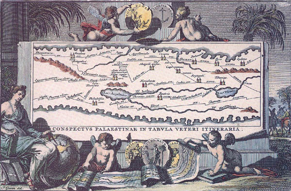
The Peutinger Map. This detail from the 13th-century Peutinger map was enlarged and a frame and color added to it when it appeared in an early 18th-century book. The detail is oriented with west on top, unlike most of the remainder of the map, which is oriented to the north. Measuring almost 90 feet in width, the Peutinger map was probably made to be taken on the road, perhaps by an army or by commercial caravans.
A number of Palestinian roads appear on the Peutinger map. One artery stands out as important for reconstructing the map of biblical roadways. This road is shown as starting at Rhinocorura in Egypt, upper left (on an adjoining panel of the map, not pictured here, we see that the road actually begins in the Nile Delta near Alexandria). The road runs past Ascalon (Ashkelon) to Azotus (written “Azoton”), then splits, only to rejoin at Caesarea.
From Caesarea, one road continues northward along the Mediterranean coast past Ptolemais (Acre), Tyre and Sidon, before coming to the right edge of this detail (the road itself continues north past Beirut and Byblos to Antioch on an adjoining panel of the map). A second road diverges from Caesarea; it passes Caparcotani (Megiddo), Scythopolis (Beth-Shean) and arrives at Tiberias, on the western shore of the Sea of Galilee. This second road from Caesarea to Tiberias fits precisely one branch of what the author calls the “International Coastal High way” (see the second sidebar to this article).
From Tyre, a diagonal road heads past Caesarea-Phillippi to Damascus and regions east.
The names and spellings of some cities on the Peutinger map follow those used by the geographer Claudius Ptolemy in the second century A.D.