Image Details

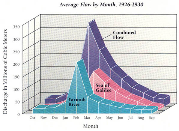
Data: Isaac Schattner, The Lower Jordan Valley
When a little is a lot. The 1 billion cubic meters of water that the Jordan discharged every year, in the days before large amounts were diverted, is not very much compared to the Nile’s annual discharge of 84 billion cubic meters. But the Jordan’s flow, especially in the lower Jordan, is wildly uneven—very high in late winter and early spring, the harvest season—thereby causing an additional impediment to farming; and very low at other times. The prolonged period of high flow results from the two principal sources of the lower Jordan’s water—the Yarmuk River and the Sea of Galilee—which reach their peak flow in February, March and April. The Yarmuk’s flow peaks in February with the winter rains in Gilead, east of the Jordan; the Sea of Galilee’s flow reaches its maximum in March and April, when Mt. Hermon’s melting snow augments the high level created by the winter rains. When the rains are heavy, great floods cover the floodplain, causing erosion and often changing the river’s course by adding or subtracting meanders. The data on this chart come from the period 1926 to 1930, a time before large diversions of the Jordan’s water had occurred.
