
Image Details
Marcel Van den Broecke / www.orteliusmaps.com
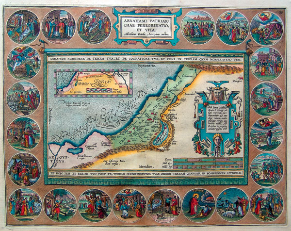
“Walk through the length and the breadth of the land, for I will give it to you,” God promises Abraham in Genesis 13:15. In 1590, Belgian mapmaker Abraham Ortelius created this map of Abraham’s world, titled “The Life and Peregrination of the Patriarch Abraham.” A friend of the prominent 16th-century mapmaker Mercator, Ortelius based his cartography on earlier maps and travelers’ tales as well as the Bible. In the small inset map at upper left, he traces what he devises were Abraham’s actual steps from Ur to Canaan, with a detour into Egypt. The larger map illustrates the sights and sites of the Holy Land. “Ter-ra Cha-naan,” as it is labeled, is dotted with steeples, denoting towns and cities. Names of ancient biblical peoples—“Ammonitae,” “Moabitae,” “Raphaim”—appear in italic type.
Surrounding the map, 22 vignettes depict critical moments in the life of Abraham from the time he is ordered to leave Ur (Genesis 12:1, to the right of the title plaque, top center), until his death and burial at the age of 175 (Genesis 25:8–11, to the left of the title plaque). The vignettes run clockwise in chronological order; the patriarch ages with each step in his story.