
The Mt. Ebal Site
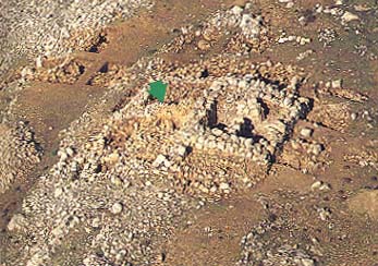
Mt. Ebal, the highest mountain (over 3,000 feet) in northern Samaria, the mountain where the curses were pronounced (Deuteronomy 27–28) and the mountain where Joshua raised his altar (Joshua 8:30–35), now figures in a bitter dispute. Long hidden under a stone heap on a northeastern ridge of Mt. Ebal, a controversial stone structure may be the remains of an independent altar—the principal structure of a bamah, or “high place”—or of a farmhouse/watchtower, according to differing interpretations of the evidence. Discovered by Haifa University’s Adam Zertal during a 1980 archaeological survey of the mountain, the site has many potsherds dating from the early part of Iron Age I (1200–1000 B.C.), the period generally accepted as the date of Israel’s settlement of Canaan.

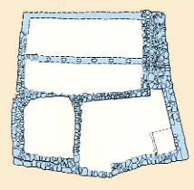
Large, unhewn fieldstones compose walls 5 feet thick and 9 feet high, forming a nearly square (24.5 feet by 29.5 feet) structure, at center-right in the photo and tinted orange in the drawing above. Laid directly on bedrock, with neither a floor nor an entrance, and originally filled with layers of stones, earth and ashes, these walls are the walls of the altar’s platform, in Zertal’s opinion. Zertal also believes they were surrounded by a slightly lower ledge, tinted blue in the same drawing. Mixed with the earthen fill were Iron Age I potsherds and animal bones that closely match the description of animal sacrifice in Leviticus 1. Two corners of this structure point exactly (with less than one degree of error) to the north and the south, an alignment that suggests to Zertal a cultic function.
Archaeologist Aharon Kempinski views the structure differently. He believes that a house was filled in to form the base for a watchtower.
The 23-foot-long wall, or ramp, marked the the arrow in the photo and tinted orange in the lower half of the drawing, also provokes two interpretations. In Zertal’s view, its 22-degree incline from left to right (as seen in the above photo) gives it the appearance of a ramp (as required by Exodus 20:26), but Kempinski argues that its width of slightly more than 3 feet is too narrow for a ramp. Kempinski regards the “ramp” as a wall and explains the incline as being the result of a common pattern of structural collapse, whereby the inner part of the wall was protected by debris from the watchtower while the outer, unprotected portion fell apart, he cites the variation in color from yellowish (protected) to whitish (exposed) as evidence for his explanation. The other walls adjoining the “ramp” are seen by Zertal as courtyard walls, tinted blue in the previous drawing, and are viewed by Kempinski as house walls (see drawing below).
A recently discovered carnelian scarab issued during the reign of Ramesses II (1290–1224 B.C.) to honor Thutmosis III (1479–1425 B.C.), helps to pinpoint the date of the founding of the site. What looks like a capital “B” in the scarab’s center is really a double bow held by a kneeling archer, far left. The cartouche of Thutmosis III appears at the far right, and a crawling salamander, an Egyptian symbol of abundance, adorns the top. A second scarab dated to Ramesses II’s reign was also found at the site.

Kempinski contends that the site comprises three phases of settlement. In the first phase, nomads or seminomads left behind pits (which Zertal believes were cultic installations); then a farmhouse arose in the second phase; and finally, after a period of destruction, a watchtower and defensive wall were built. (Kempinski’s third phase is shown in the drawing below.) But according to Zertal, there are no remains of a nomadic or seminomadic settlement, very little domestic pottery, no evidence of a destruction and no need for a watchtower because no ancient road passed near the site.

As explained in the accompanying article, Michael Coogan concludes, based on the criteria he has developed for identifying cult sites, that the Mt. Ebal site is indeed a cult site.