
Using Pottery Forms and Width Stratigraphy to Trace Population Movements
Pottery forms change gradually, not all at once. That is why pottery sequences always overlap. Typically, one form gradually declines as another increases; thus, it becomes especially important in a survey (where for the most part we do not excavate the sites) to determine the relative quantity of specific pottery forms collected on the surface.
In our survey of the area allotted to the tribe of Manasseh, we used these relative quantities to date the movement and chart the direction of the new settlers.
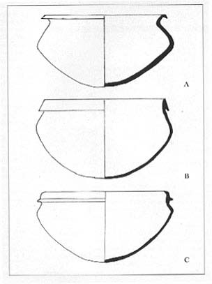
During the Late Bronze Age (LB) (c. 1550–1200 B.C.E.), a single type of cooking pot was used throughout Canaan. This vessel, designated Type A by Amihai Mazar in his excavations at Giloh, has an everted triangular rim. It is well represented at all LB levels.11 In our excavation at Mt. Ebal, this is the principal type of cooking pot found in stratum II, which can be securely dated to the 13th century B.C.E. by two Egyptian scarabs and Mycenaean IIIB sherds.
Type A disappeared during the first half of the 12th century and was gradually replaced by the Type B cooking pot, a so-called Israelite vessel with a tongued rim—erect or slanted. Type B, a direct continuation of Type A, was probably introduced as Israelite potters imitated Canaanite vessels, but added their own variations. Type B is securely dated to the 12th century and was used until the middle of the 11th century B.C.E.12
In turn, the Type C cooking pot replaced Type B. Type C has a long tongue on the rim with a very low ridge. It appears from the middle of the 11th century through the 10th century B.C.E.13
We began with the assumption that the earlier a site was founded, the more remains of Type A cooking pots we would find there. True, Types B and C might be found there as well, but a relatively large quantity of Type A would indicate that the site was founded in the 13th century. Similarly, relatively high quantities of Types B and C would indicate settlement principally in the following centuries. I should stress that these sites have not been excavated. Our survey work is based on the principle that when you have a large number of sites, it is possible to date the founding of the site by the relative quantity of particular types of pottery found on the surface. The following chart explains this model:
In this chart, we list the relative quantities (in percentages) of the three different pottery forms, and from this we determine when the site was founded, when it flourished (with the largest population) and when it had what we call, for want of a better term, a medium presence.
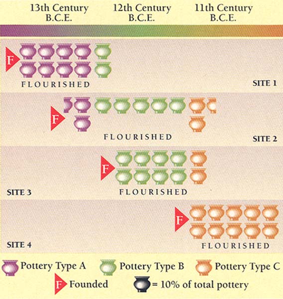
Thus we see that Site 1 was founded and flourished in the 13th century B.C.E. (80 percent of the cooking pots were of Type A) and had a medium presence in the 12th century. Site 2 was also founded in the 13th century (25 percent of the cooking pots were of Type A), but it flourished in the 12th century (50 percent of the cooking pots were of Type B). In this same way, Sites 3 and 4 can be dated and analyzed.
When numerous sites have been analyzed in this way, the next question is whether we can trace a direction of movement. In the chart, obviously Site 4 was founded after Site 1. When we have many sites like this, it is sometimes possible to trace the direction of movement, and even identify the point of entry of the new population.
We call this width stratigraphy, the distribution of dated material over a wide surface, as opposed to using the same method in depth in a single site during excavation. Obviously, there is a problem of accuracy here. But archaeology is never an exact science. If used properly and cautiously, width stratigraphy can be an extremely important tool, providing us with invaluable data.
Some patterns will naturally be more revealing than others. For example, 19th-century forts in the western United States have later pottery than East Coast villages of the 17th century. Tracing the relative quantities of pottery can indicate an east-west movement of the settlers.
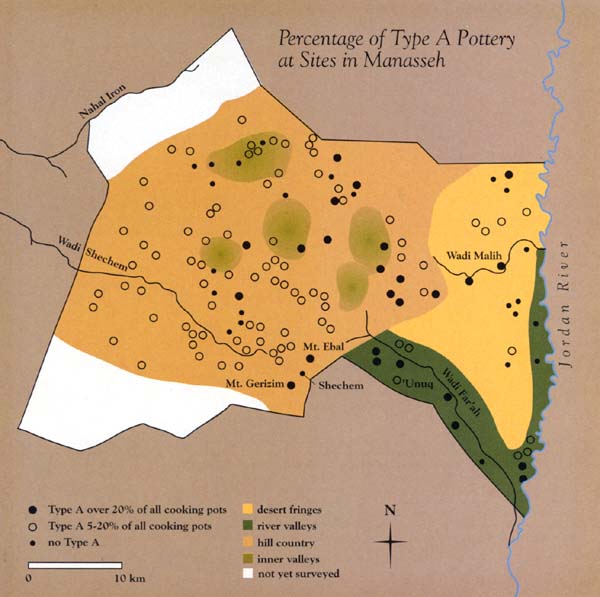
This method is not entirely new: It has been used to follow the direction of Mycenaean settlements in the Peloponnesus, as well as in other parts of the world. We are fortunate that our data in the territory of Manasseh allow us to draw similar conclusions regarding the Israelites’ entry into and movement within the territory of Manasseh.