
Who Found What on the Ophel

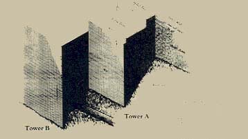
Spanning more than a century, the work of four excavators appears on this plan. Digging vertical shafts and lateral tunnels in 1867, the British engineer Captain (later Sir) Charles Warren discovered the outer face of two ashlar-built towers (A and B) from the First Temple period (see Warren’s drawing). Warren crawled within the shafts and tunnels and made measurements from which he drew architectural remains such as these towers, which would not emerge until excavated by archaeologists more than a century later. Warren found that the larger tower (B) measured about 75 by 60 feet and had a preserved height of more than 60 feet; and that the dimensions of the smaller tower (A) were about 25 by 50 feet, with a preserved height of 30 feet. Kathleen Kenyon, in the 1960s, dug a square (SII) and exposed some of the smaller tower (A). Subsequently, as part of a larger, ten-year excavation (1968–1977) in the area beside the Temple Mount’s southern wall, Benjamin Mazar uncovered the areas shown in blue, bringing to light part of the structure marked “C,” although not interpreting it as a gateway. This building consists of a central passageway flanked by two chambers on each side. (The preserved walls appear in solid black on the plan, while dotted lines outline reconstructions on the basis of the finds in black.) Finally, since 1986, Benjamin Mazar’s granddaughter Eilat has excavated the areas shown in yellow. Among her finds are a royal storage building (D) containing 12 storage jars called pithoi (shown as white circles). She also investigated the area between the square rooms of Building C and found there a lime floor. The floor extends beyond the threshold of Building C’s central passageway in the direction of Warren’s large tower (B), suggesting that this was a passageway to which the tower was connected, rather than part of a separate building.
A miniature reconstruction of these remains, part of a larger model of Jerusalem in First Temple times (see “Visualizing First Temple Jerusalem,” in this issue), appears in the photo. This model vividly shows how the remains stand in relationship to the hillside schematically presented as a series of terraces that rise from the bottom to the top of the photo. Tower B stands in the foreground at center. The level lime floor connects the top of the tower with the passage through the inner gate (Building C), at left in the background. The gap in the wall beside this passage reflects the lack of remains rather than an opening in the original structure. Similarly, the model omits Tower B’s presumed superstructure and the hypothetical outer gate. The horizontal red lines represent the supposed location of the City wall.

In Eilat Mazar’s interpretation of these findings, Building C was an inner gatehouse in a larger gate-complex comprising the two towers. To enter the royal quarter, people would pass through an outer gate, as yet undiscovered, on the left between Tower B and Building C, thereby entering a courtyard. This courtyard was an area enclosed by the existing gate, the undiscovered outer gate and the two towers; people would then turn left and walk through the passage of Building C, the inner gatehouse.