Putting the Bible on the Map

An understanding of geography is essential to an understanding of many sections of the Bible. For this reason, an up-to-date atlas—maybe more than one—is a tool no serious student of the Bible can be without.
There are at least four reasons why geography is important. First and perhaps most significant, the Biblical materials cannot be accurately studied apart from their time and place—their history and geography. Some great literature can be, but the Bible is not this type of literature. Both the Old and the New Testaments are rooted in a storied place—a land that holds memories of God’s dealings with his people. For the Israelites there was no timeless space or spaceless time.1 The God of Scripture was the Lord of places as well as times. Biblical theologians correctly point out that the Bible is not simply abstract theologizing about God. The Bible is the story of God acting in a covenant relationship2 with Israel. In the Biblical drama, most acts of God are not obscured on a foggy stage; they are set in specific places. The Biblical characters walk across a storied earth. And it is these stories that gave the Biblical characters their religious understanding. John Smith (Pocahontas’s husband) said it very well in his Generall Historie of Virginia, published in 1626. “As geography without history seems a carkasse without motion; so history without geography wanders as a vagrant without a certain habitation.”3
The Biblical drama lasts about 1,900 years, spanning many different times and places. Though addressed to everyone, it is set in a history of a particular people, subjected to specific cultural influences within a limited geography. A good historical geography aid is essential for understanding the material environment of the Israelites as they received the word of the Lord through their prophets. A study of historical geography helps make the message more tangible, richer and more vivid.
Second, the geography of the Bible is important because it provides the setting for the drama, which has a greater variety of scenery on a smaller stage than almost anywhere else in the world! Most of the Biblical narrative occurs on a stage 50 miles wide and 150 miles long (from “Dan to Beer-Sheva,” [Judges 20:1, 1 Samuel 3:20, 2 Samuel 3:10, etc.]). Yet within this small compass, Mt. Hermon, with snow year-round in the canyons of its northern slope, rises over 5,000 feet above sea level, and the salty, forbidding Dead Sea simmers 1,300 feet below sea level, the lowest place on the surface of the earth. This enormous range in elevation also gives Israel one of the planet’s greatest varieties of climate, vegetation and animal life within a small area. And to top it off, through the middle of the stage runs the longest scar in the earth’s crust—the Syrian-African Rift Valley, which includes the Jordan Valley north of the Dead Sea and the Aravah, the valley that extends from the Dead Sea south to the Gulf of Eilat. This geographical feature exposes geological strata a mile deep.
Two cities, dots side by side on a map of Israel, often have entirely different temperature, rainfall, vegetation, soil fertility, animal life, and security factors. A good Bible atlas must therefore show more than site identifications, rivers, and political borders. Unfortunately, most Bible atlases stop with the dots and arrows. A proper geographical Biblical map must depict a site’s unique geographical setting to show the influence of geography on its history.
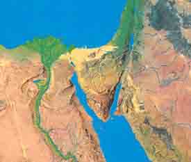
Third, Israel’s geographical setting is important in interpreting the Bible in its larger setting. The Promised Land is located between deserts (the Sinai and Sahara to the south and southwest and the Arabian Desert to the east). On the west is the Mediterranean Sea. The deserts and the sea all influence the Land throughout the Biblical drama. Israel is located at the only place in the world where three continents touch: Africa, Asia, and Europe. Whenever one was strong, its armies marched through Israel to one of the others, looting and destroying as they went. When Africa was strong the Egyptians usually marched through the Land; when Asia was strong, it was the Sumerians, Assyrians, Babylonians and Persians; when Europe was strong, it was the Hittites, Phoenicians, Philistines, Greeks, Romans or Crusaders. For much of its history, Israel was restricted to the mountainous areas, the land bordering the edge of the southeastern deserts. Perhaps the eternal struggles—between the nomadic and the settled peoples, between those living within a distinct culture and those who were assimilated, between the downtrodden and those with political power—provided the appropriate setting for the cultivation of spiritual values. The great Biblical geographer George Adam Smith made the point this way:
“How could such a people be better framed than by selection out of that race of [persons] which have been most distinguished for their religious temperament, and by settlement on a land both near to, and aloof from, the main streams of human life, where they could be at once spectators of history and yet its victims, where they could enjoy personal communion with God and yet have some idea also of His providence of the whole world; where they could gather up the experience of the ancient world, and break with this into the modern? There is no land which is at once so much a sanctuary and an observatory as Palestine: no land which, till its office was fulfilled, was so swept by the great forces of history; and was yet so capable of preserving one tribe in national continuity and growth: one tribe learning and suffering and rising superior to the successive problems these forces presented to her, till upon the opportunity afforded by the last of them she launched with her results upon the world. It is the privilege of the student of the historical geography of Palestine to follow all this process of development in detail.”4
Finally, accurate geographical information is often necessary to interpret Scripture correctly. Biblical research in conjunction with archaeology and other disciplines frequently makes new discoveries. Biblical atlases are in constant need of revision. Archaeological surveys and excavations are adding to the available information almost daily. The Bible mentions fewer than 400 settlements. More than 6,000 archaeological ruins are candidates from which to select the correct locations of the 400 sites. Because of war, pestilence, famine, earthquake and time itself, the vast majority of Biblical towns have been transformed into unrecognizable piles of rubble. More has been discovered in our own century to help put Biblical sites on the map than in all the centuries previous to ours. The responsible Bible student not only needs to take account of these recent discoveries, but he or she must also allow for the uncertainties that remain.
Although visual maps were known when the Bible was written, none was included in any Biblical text that has survived. What the Bible does give us are some literary maps. Genesis 10, often referred to as “The Table of the Nations,” may be a verbal summary of a map used by the Phoenicians. This literary map does not contain the name Israel; perhaps that is because it is probably at least 3,500 years old.
Joshua 13–19 gives us the major geographical description of Israel, delineating the borders of the twelve tribes. Other books of the Bible provide extensive geographical information, demonstrating the importance the Biblical writers themselves attached to geography.
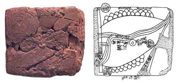
The oldest known visual map was uncovered at Nuzi in northeast Iraq in 1931. Written in Old Akkadian cuneiform, the map probably dates to sometime before 2150 B.C. and shows Ebla (Tel Mardikh) in the lower left corner. (See “Ur and Jerusalem Not Mentioned in Ebla Tablets, Say Ebla Expedition Scholars.”)

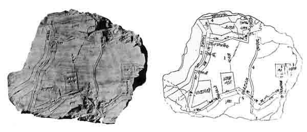
The oldest city map known is of Nippur. This map is written in Sumerian ideographs and Akkadian cuneiform and was found at Nippur in 1900. It probably dates to about 1500 B.C.

The ancient Egyptian contribution to geography, like the Hebrew one, was, for the most part, literary rather than visual. Thutmose III recorded a number of Biblical towns in a list of his military conquests in Canaan in about 1468 B.C. Pharaohs Seti I, Ramesses II and Merneptah left us additional city lists from the 13th century B.C. Pharaoh Shishak (924 B.C.), who conquered Israel in the fifth year of Rehoboam’s reign (1 Kings 14:25–28) listed 156 Israelite cities in the records of his military victories.
Two important modern discoveries of artifacts dating from the beginning of the first millennium B.C. helped to map more precisely specific regions north and east of Judah. The Mesha Stele of the ninth century B.C., discovered in 1868 in Dibon, Jordan, locates cities east of the Dead Sea in Biblical Ammon and Moab. The Samaria Ostraca, from the eighth century B.C., name many towns of the tribes of Ephraim and Manasseh not mentioned in the Bible.
The city lists of the Assyrian and Babylonian campaigns against Israel and Judah help locate many Biblical towns because they are listed in marching order. The leaders of the major military campaigns are Tiglath Pileser III (732 B.C.), Shalmaneser V (724 B.C.), Sargon II (701 B.C.), Sennacherib (701 B.C.), Esarhaddon (669 B.C.), and Nebuchadnezzar (605–585 B.C.).
Ancient sources describe many Greek and Roman period maps. The two most helpful to Biblical studies are the books of 1 and 2 Maccabees, which show how the Greeks renamed many Semitic cities, and the works of Josephus Flavius, which list over 100 towns and other features from the Roman period.
Eusebius, a Christian scholar of the fourth century, compiled an alphabetical index of all Biblical towns using names of his own day, called the Onomasticon. It is especially valuable because it gives the distance or direction to a better-known nearby location. The Onomasticon in the original Greek has been lost, but it is preserved in a Latin translation by Jerome (345–420 A.D.).
Many pilgrim diaries from the Byzantine period also help locate Biblical sites. The most important are those of the otherwise nameless Pilgrim of Bordeaux (333 A.D.), Egeria (shortly before 400 A.D. [see review of Egeria’s Travels to the Holy Land, Books in Brief, BAR 09:02]), the anonymous Pilgrim of Piacenza (570 A.D.), and a Celtic prelate named Arculf, who visited the Holy Land in 670 A.D. after the Arab conquest.
The Talmud (a written compendium of Jewish oral law completed by about the fifth century A.D.) contains many geographical references.
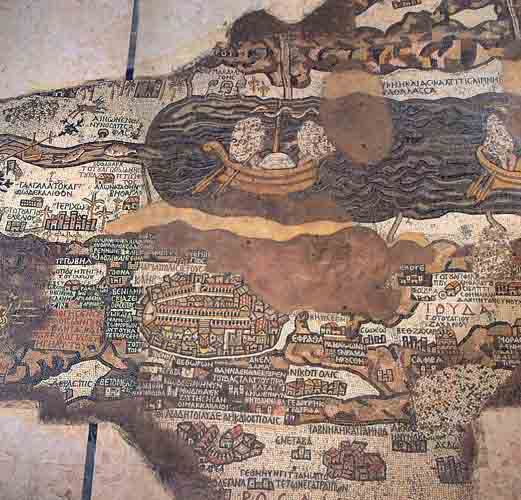
The oldest extant map of Palestine is the famous Madaba map, preserved in the mosaic floor of a sixth-century church in Madaba, Jordan. The map includes 130 locations, along with artwork expressing geographical and other features, such as the fish in the Jordan River turning around to avoid the salty Dead Sea. Jerusalem is drawn on this map at a scale ten times larger than the rest of the map. The map was only partially preserved and was first published in 1896 by Kleopas Koikylides, librarian of the Greek Orthodox Patriarchate in Jerusalem. The map had been damaged in 1890 during renovation of the church.

During the Middle Ages geographers and mapmakers abounded. Following are but a few of the names from these centuries. In 1154, a Moslem named Idrisi produced a beautiful map of the Holy Land with colored topographical features showing his journey to Mecca. In 1170, a Jew, Benjamin of Tudela, wrote a detailed diary of a trip from Spain through Israel to Persia. A Christian scholar named Burchard published A Description of the Holy Land in 1283. In 1320, Rabbi Astori wrote the first geography in Hebrew.
Advances in cartography and geography were also made during the Renaissance and thereafter. Gerhardus Mercator introduced his system of parallel meridians and latitudes in 1569. Adrian Reland produced a monumental work documenting previous geographies in 1714. Samuel Cruquius proposed the idea of contour lines in 1730.
The story of the modern discovery of Biblical sites could be a fascinating volume in itself. Here we can but mention the great names: the American scholar Edward Robinson who in 1835 and 1852 identified more than 100 Biblical sites; the U.S. Navy Captain William F. Lynch who in 1848 mapped the Sea of Galilee, the Jordan River, and the Dead Sea, determining for the first time that the Dead Sea was 1,300 feet below sea level (see “The United States Navy Explores the Holy Land,” BAR 02:04, by Emmanuel Levine); Claude Regnier Conder and H. H. Kitchener who published 76 beautiful maps with contour lines in 1880 for the London-based Palestine Exploration Society; George Adam Smith whose Historical Geography of the Holy Land was an influence on later geographers; and Père Felix Abel (1878–1953) of the French École Biblique in Jerusalem who more than any other scholar before him established the use of pottery to locate Biblical sites.
Most Israeli scholarship since the birth of the state in 1948 has been influenced by two great historical geographers: Yohanan Aharoni, who surveyed Upper Galilee and wrote The Land of the Bible, and Michael Avi Yonah, who wrote hundreds of books and articles on the Persian, Greek, Roman and Byzantine periods.
Geographies and atlases of the Bible published in the 20th century number literally in the hundreds. The survey published below includes simply the most important and best of the most recent. Modern mapmaking has made great strides in recent years. Unfortunately, Biblical atlases rarely make use of these advances. In the future, we can look forward to Biblical atlases produced with laser and computer technology, assisted by aerial photography, showing how the land would look from different viewing planes (reflectance maps). Even the arbitrary grid system for locating sites may one day be replaced by a more effective system of location. But all this is in the future.
For the present we must work with what we have. “Nineteen Bible Atlases Compared” provides a list of the pluses and the minuses of the major Biblical atlases and geographies that are currently available. Most of the listed atlases are still in print; any atlas for which a price is not indicated is out of print and must be obtained from a library.
An understanding of geography is essential to an understanding of many sections of the Bible. For this reason, an up-to-date atlas—maybe more than one—is a tool no serious student of the Bible can be without.
You have already read your free article for this month. Please join the BAS Library or become an All Access member of BAS to gain full access to this article and so much more.
Already a library member? Log in here.
Institution user? Log in with your IP address or Username
Endnotes
G. Ernest Wright and Reginald H. Fuller, The Book of the Acts of God (Anchor Books, Doubleday & Company: Garden City, New York, 1960), pp. 3–16.
John Smith, Generall Historie of Virginia, New England, and the Summer Isles: With the Names of the Adventurers, Planters and Governours from Their First Beginning, Ano: 1584 to This Present 1624, in the Fifth Booke.
