
Eilat Region
Introduction
The Eilat region is arbitrarily defined as the southern tip of modern Israel, from the Shizafon junction in the north to Eilat in the south. The area is hyper-arid, with an annual average rainfall of only 28 mm, an annual potential evaporation rate of 4,000 mm, and summer mid-day temperatures reaching over 40 degrees C. As a result, perennial water sources are rare, the Saharo-Arabian vegetation is restricted to the wadi beds, and the carrying capacity for animal and man is low. The landscape varies and changes abruptly, with mountains up to 892 m above sea level, broad valleys (‘Uvda, Sayarim, and Se‘ifim), the deep Arabah, and the shores of the Gulf of ‘Aqaba. The lithology is also rich and variegated, with igneous and metamorphic rocks, sandstone, and limestone.
Given these environmental conditions, the site density and settlement pattern of the area is surprising. Ancient sites have been recorded in the region since 1861, but more detailed study began in the early twentieth century with the surveys of A. Musil, F. Frank, and N. Glueck, followed by the survey of B. Rothenberg during the 1960s. Further surveys have been conducted since 1978, mainly in preparation for the redeployment of the Israel Defense Forces from Sinai and prior to various development projects. To date, only c. 7 percent of the area has been covered by a detailed archaeological survey, and c. 1,500 ancient sites have been recorded in an area of 1,200 sq km. These sites represent a continuous sequence of settlement over the past 10,000 years, in contrast to a pattern of alternating periods of settlement and abandonment as revealed in the Negev Highlands and in Sinai. The main factors that influenced the region’s history were the copper and other mineral resources, the ancient international roads that crossed the area, and its geopolitical and strategic position. These resulted in a settlement density that defies the environmental conditions.
Following is a short description of the cultural remains of the region, by period. Due to lack of space, copper mining and production will only be briefly mentioned.
Excavation and Survey Results
THE PALEOLITHIC PERIOD. The earliest indications of human presence in the area are flint hand axes occasionally found on the surface, dated to the Lower and Middle Paleolithic. A remarkable find is a collection of c. 1,500 hand axes discovered around the remains of an ancient lake at Naḥal Ẓiḥor (by H. Ginat and I. Saragusti), dated between 1.5 and 0.25 million years ago. Mousterian and Epipaleolithic flint tools are also found on the surface in the Eilat region.
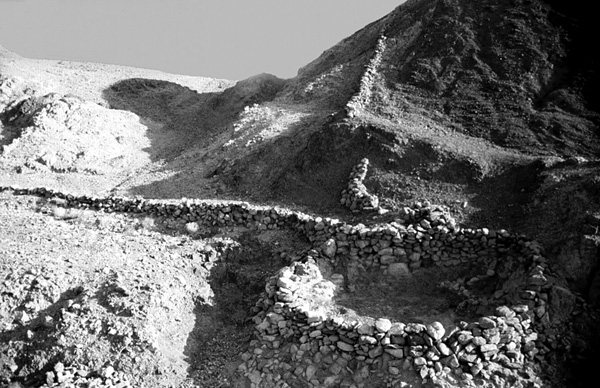
THE PRE-POTTERY NEOLITHIC PERIOD. Thirteen Pre-Pottery Neolithic B sites have been identified to date. Four of these sites have stone-built dwellings, three sites of which are located in the ‘Uvda Valley. Two habitation sites have been excavated, Naḥal Re‘u’el (by A. Ronen et al.) and Naḥal ‘Issaron (by N. Goring-Morris and A. Gopher). They consist of clusters of circular rooms built in a compact, “bee-hive” configuration, with only limited open spaces. Each site accommodated one extended family of hunters and gatherers, who probably inhabited them from autumn to spring and returned to the sites annually. Ample arrowheads and game animal bones indicate hunting, while the many grinding stones, silos, and ovens indicate exploitation of wild cereals for preparation of porridge and bread.
THE LATE NEOLITHIC AND CHALCOLITHIC PERIODS, AND EARLY BRONZE AGE I–IV. While the Late Neolithic and Chalcolithic periods are culturally distinct from the Early Bronze Age I–IV in Near Eastern archaeology, in desert areas it is often difficult to distinguish between them. The periods spanning the sixth to third millennia BCE (calibrated dates) will therefore be described here together. In the Negev and Sinai, only a limited number of sites have been dated to the sixth–fourth millennia BCE. In the Eilat region, however, a number of habitation, cult, and burial sites are dated to this period, as are copper mines and smelting sites. Following is a brief description of sites according to their types.
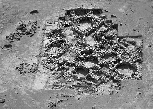
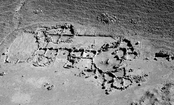
Settlement Pattern and Subsistence. In 3 out of 20 excavated habitation sites in the ‘Uvda Valley, occupation levels were dated by finds and by 14C determinations to the sixth and fifth millennia BCE (calibrated). At Naḥal ‘Issaron, stratum B included a circular open space surrounded by circular rooms, while at sites 7 and 9 these periods were reached only in probes, below the later architectural remains. In both sites 7 and 9, layers of sheep/goat dung were found, indicating the beginning of grazing during the sixth millennium BCE. The introduction of herding to the desert (some 1,000 years after its emergence further north) found expression in several new types of installations, including stone-built corrals, tent camps, and predator traps. The appearance of corrals gave rise to a new type of habitation site that occurs in large numbers throughout the Near Eastern deserts, consisting of circular courtyards with clusters of circular rooms, although square rooms are found as well. This type of site is mainly dated to the fifth–third millennia BCE, but in some desert areas it is still in use today. It usually represents semi-nomadic, herding societies, but in the ‘Uvda Valley comparatively large amounts of agricultural flint and stone tools were found. These include flint adzes, stone hoes and two ard-tips (early plough tips), hundreds of glossed blades used for harvesting and threshing cereal, and hundreds of grinding stones. Additional remains indicating the importance of agriculture in the ‘Uvda Valley are well-built silos in the habitation sites, and botanical remains of olives, domesticated cereal, and grape pollen. The remains of earth embankments and limans along the eastern side of the valley indicate that the flood-based cultivated fields covered c. 3,000 a.
Thirty-two threshing floors have been recorded in the valley, 29 of which are concentrated in an area of 0.5 by 2.5 km. One of these (excavated by U. Avner), revealed a technological evolution in threshing. In the first stage (fifth–fourth millennia BCE), a cleared rock surface, 120 by 18 m, served several families as a threshing floor where yields were beaten by hand. In the second stage (late fourth millennium BCE), a flint workshop was built, partially on top of the cleared area. Most of the tools produced there were scraper-like and were probably used as sledge blades, indicating the emergence of the animal-drawn threshing sledge. In the next phase (c. 3000 BCE), two circular threshing floors were hewn into the cleared rock surface. Finds indicate continuation of threshing in the Late Bronze–Early Iron Age and the Nabatean and Early Islamic periods, as well as by the Bedouin population until the mid-twentieth century. The concentration of threshing floors in the ‘Uvda Valley is the largest and oldest known to date in the Near East.
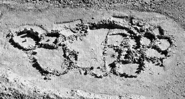
The introduction of both herding and agriculture dramatically increased the population of the region. In the surveyed area of the ‘Uvda Valley, the three Pre-Pottery Neolithic B sites expanded to 154 habitation units in the fifth–third millennia BCE, over a 40 sq km region. Some of them were permanent settlements.
Seven “desert-kites” (gazelle traps) are known in the area; two of these were excavated (by U. Avner and A. Holzer). The “arms” of a desert-kite near Kibbutz Samar are 114 and 127 m long, respectively, and the enclosure is 8 m in diameter. It was probably built during the fourth millennium BCE and later overlaid by an Early Bronze I–IV habitation unit. The arms of the desert-kite at Har Shaḥmon near Eilat are 47 and 38 m long, respectively, and the enclosure is 8 m in diameter, preserved to a maximum height of 2 m. On the basis of finds and 14C and thermoluminescence dates, it was built during the Chalcolithic period and reused in the Iron Age. Later, Mameluke and Ottoman tombs were constructed inside the kite.
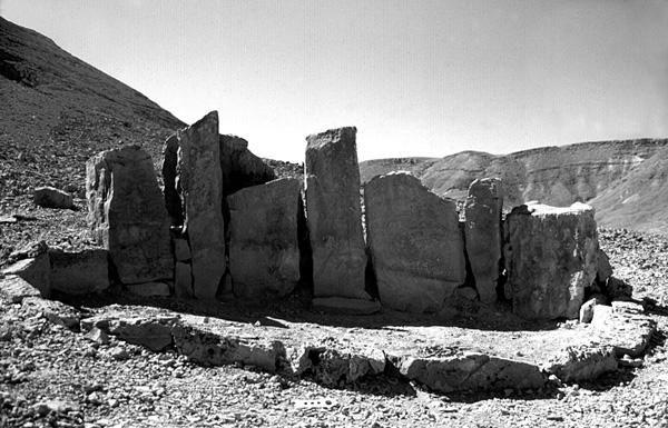
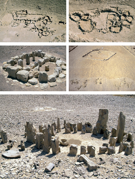
Cult and Burial. Cult and burial sites are common in the Eilat region. To date, 92 maṣṣebot (standing stones) sites, 28 open-air sanctuaries, and other cult installations have been recorded. Eight maṣṣebot sites were excavated in the area (seven by U. Avner, one by E. Eisenberg). A brief description of three of these sites follows.
At the top of Ma‘ale Yethro, a group of seven maṣṣebot was set next to the ancient winding trail leading from the Yotvata oasis to the ‘Uvda Valley. They are up to 105 cm high, arranged as alternating broad and narrow stones and facing east. One stone was found fallen, the others were standing upright or slightly tilted. A semi-circular stone cell was built on the eastern side, in which a flat stone (an offering table) was laid at the foot of the central maṣṣeba. Flint and pottery sherds collected on the surface and in the excavation date the site to the fifth–fourth millennia BCE, while a silver pendant, found next to the stone table, is dated on stylistic grounds to the Late Bronze Age.
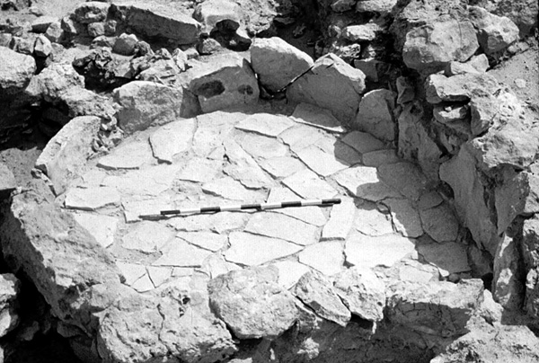
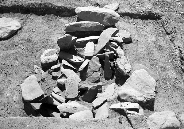
Next to habitation site 9 in ‘Uvda, a broad standing stone was observed, with a rectangular stone pavement on its western side. Excavation exposed the complete stone, 120 by 122 cm, and several installations and hearths. The lower hearth, at the foot of the maṣṣeba, yielded a 14C date of the early sixth millennium BCE. A hearth at a higher level was dated to the mid-third millennium BCE. Early Bronze Age IV pottery sherds were uncovered between the pavement stones. The shrine was probably in use for c. 4,000 years, as was the adjacent habitation site.
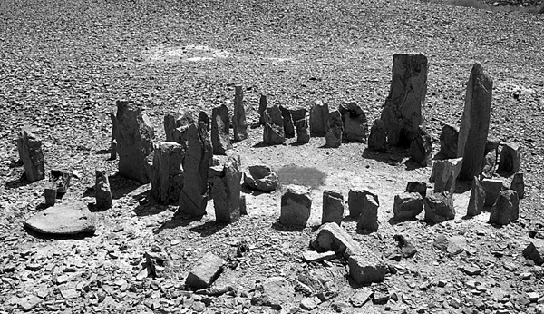
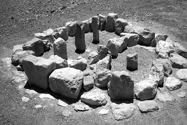
Near the modern settlement of Ma‘ale Shaḥarut, east of the ‘Uvda Valley, a circle of maṣṣebot was found, c. 5 m in diameter. Most of the maṣṣebot (53 in number) had fallen, while 12 were still upright or tilted. Inside the circle, a stone basin was found next to a hearth that yielded a 14C date of the mid-fifth millennium BCE. Following the dig, the fallen maṣṣebot were reerected.
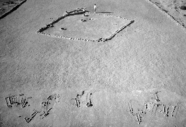
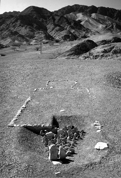
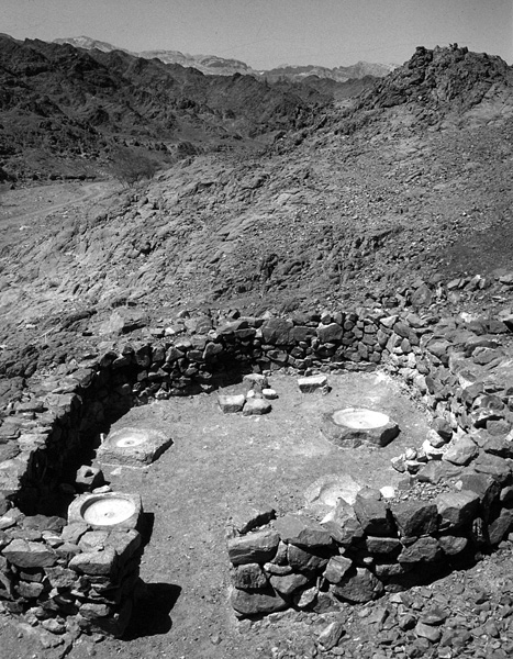
Four open-air sanctuaries were excavated in the Eilat region. One in the ‘Uvda Valley (by O. Yogev) consists of a square courtyard, c. 12 by 12 m, delineated by one course of a double line of stones and containing five sunken altars. The western corner is cut by an elongated cell, 4 by 1.7 m, built of flat stones set vertically, in which a group of 17 small maṣṣebot was found. Some 8 m to the east, a unique depiction made of small flagstones set vertically into the ground was excavated (by O. Yogev and U. Avner). The depiction includes 16 leopards facing southeast and one oryx facing west. Images executed in the same technique have also been discovered next to open-air sanctuaries in eastern Sinai and near maṣṣebot sites in the southern Negev.
One sanctuary excavated by Avner in a cluster of 13 open-air sanctuaries near Har Shani was somewhat similar in ground plan to the one at ‘Uvda. Although not well preserved, this sanctuary yielded a variety of finds ranging from the Chalcolithic to Byzantine periods, including a fragment of a Late Kingdom Egyptian ushabti figurine and Midianite pottery sherds. Two other open-air sanctuaries excavated in Eilat will be mentioned below.
Burial grounds and individual tombs are common in the region, but to date only two sites have been excavated. One is in Eilat, consisting of 22 well-built tumuli tombs, several temporary graves, two open-air sanctuaries, and additional cult installations. It presents several important innovations in burial customs. The temporary graves were shallow and used for primary burial, while the tumuli tombs were used for secondary burial. Two types of maṣṣebot were found associated with the tumuli tombs. One consists primarily of pairs of broad stones set on the outer, eastern perimeter of the tumulus; the other includes one to three individual stones, usually narrow, set inside the tombs. Many hearths were found around the tombs, with 66 uncovered around two adjacent tombs. East of both tombs, stone installations were excavated. One contained the remains of a juniper tree trunk, which most probably served as a sacred tree (Asherah). Although all the tombs were robbed in antiquity and most were damaged or ruined by modern mechanical equipment, the surviving tombs were rich in artifacts. All of the deceased individuals were interred with grave goods including winged arrowheads, a polished stone axe, sandstone bowls, two of which are decorated in relief, grinding stones, many flint tabular scrapers, Late Neolithic pottery fragments, hundreds of seashell beads of various types, faience and glazed steatite beads imported from Mesopotamia, one copper bead, copper nodules, and a lump of red realgar (Ass) imported from Anatolia. Nine radiometric dates of charcoal from the hearths and one from the sacred juniper trunk yielded a sequence of 1,200 years of use of the site, from c. 5430 to 4230 BCE (calibrated). The two adjacent open-air sanctuaries differ in design and dimensions. The smaller one (3.3 by 7.7 m) contained a group of 99 maṣṣebot. Two were c. 70 cm high while all others were 10–36 cm high. Twelve maṣṣebot were found upright or tilted, while all others had fallen.
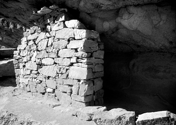
Another group of tombs was excavated (following robbery) in a rock shelter near Ma‘ale Shaḥarut. In one tomb, the front wall was well built and preserved to its full height of 2.8 m. The tomb contained a few human bones, a broken red-burnished jug dated to the Early Bronze Age I, fragments of flax fabric, one small fragment of sheep’s wool, and botanical remains, including domesticated barley and wheat. A similar but poorly preserved tomb contained a well-built silo, faience and seashell beads, and a decorated bone bead. Three other tombs in the rock shelter are semi-circular. Two of them contained the remains of flagstone roofs overlying wooden beams. Radiometric dates from the beams yielded dates around 2000 BCE (calibrated). Tombs in rock shelters were recorded at additional sites in the ‘Uvda Valley and at several locations in the Negev.
The archaeological remains discussed here represent part of a broader cultural scenario and a complete sequence of settlement from the sixth to the third millennium BCE. During this time, a continuous development took place in agriculture and copper production, and the number of cult sites greatly increased. Around 2300 BCE changes in life style occurred, with the beginning of the Early Bronze Age IV. In the ‘Uvda Valley, square rooms were abandoned in favor of circular rooms, indications of permanent settlement disappeared, and the number of agricultural tools decreased. Most probably, subsistence emphasis shifted toward herding and mobility. Paleoclimatic research demonstrates that abrupt global climatic change brought about these cultural changes. Nonetheless, many habitation and burial sites in the Negev indicate that human presence in the desert did not cease.
THE MIDDLE BRONZE AGE. The southern limit of settlement in the Middle Bronze Age appears to have been the Beersheba Valley. No Middle Bronze Age II sites have been identified in the Negev Highlands or in Sinai. In the Eilat region, however, several sites have yielded finds from this period. Pottery sherds of a straight-walled cooking pot, dated to the Middle Bronze Age II, were found in the open-air sanctuary of ‘Uvda and on an adjacent threshing floor. At the Eilat burial site, one interment outside a tomb was accompanied by similar sherds. The major site of the period is a large copper mine with smelting installations on a hill near Be’er Ora, which yielded four 14C dates, all around 1750 BCE (calibrated). These sites indicate that the desert was not abandoned during this period and more contemporary remains may be identified in the future.
THE LATE BRONZE AND IRON AGES. No sites have been dated to the Late Bronze and Iron Ages in the desert areas of the Negev Highlands south of the Beersheba Valley; while in Sinai, sites have been recorded only in the Mediterranean coastal area. In the Eilat region, however, various activities took place, clustering around copper production centers. Evidence for copper mining and smelting are mainly known from the Timna‘ Valley, but also from Naḥal ‘Amram, Naḥal Roded, and Naḥal Reḥav‘am. Copper production peaked under Egyptian control, from the reign of Seti I to that of Ramses V (c. 1300–1150 BCE), based on inscribed artifacts from the Timna‘ sanctuary. Nevertheless, 14C dates and finds indicate mining and smelting by local populations before and after the Egyptian presence, throughout the second and first millennia BCE.
An important site of this period is the casemate fortress of Yotvata, guarding the nearby water source and the road along the Arabah. Pottery from the fortress (excavated by Z. Meshel) consists of vessels similar to the types found in Timna‘ Valley, including a fragment of a large, painted Midianite bowl. However, some jars are Edomite, dated to the eighth–seventh centuries BCE. An interesting find is a fallen maṣṣeba in the fortress gate.
In the ‘Uvda Valley, pottery sherds of the Late Bronze–Early Iron Age were found on several threshing floors, in cultivated fields, and in 40 tent camps. In addition, the remains of a “four-room” building (9 by 11 m) were recorded at the mouth of Naḥal Yethro, containing the same pottery types as in the Timna‘ Valley. Probes (by U. Avner) confirm the building’s date. It seems that a fairly large agro-pastoral population lived in the valley in this period, while the “four-room” building served as an administrative center. Most probably, portions of the cereal yields were transferred from ‘Uvda to the Timna‘ Valley (half a day’s walk) and to other copper mining locations for consumption by miners, smiths, and others. Pottery sherds of the period were also collected in several tent camps along the Eilat-‘Uvda road. Radiometric dates (14C and TL) from the Har Shaḥmon desert-kite indicate its reuse around 1500 BCE.
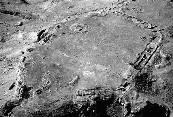
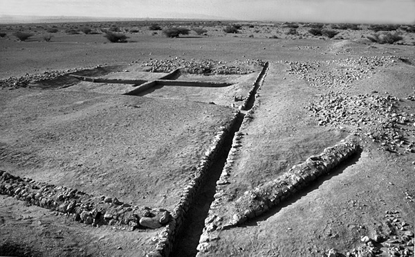
The most notable Iron Age site in the region is Tell el-Kheleifeh, 0.5 km east of the Jordanian border and 0.5 km north of the Red Sea shore. N. Glueck, who excavated the site from 1938 to 1940, identified two main architectural units, said to be dated to the periods of Solomon and Jehoshaphat (tenth and ninth centuries BCE). One is a casemate fortress (45 by 45 m) with a central four-room building; the other is a larger and more massive fortification (75 by 67 m) with a fortified gate on the south. G. D. Pratico, who analyzed the site’s pottery, found no evidence for occupation earlier than the eighth century BCE. Recent excavation at the tell (by the late M. L. Mussell in 2002) has provided new information on the architecture and stratigraphy of the site. The earliest identified remains now are two mastaba tombs in the north (one excavated by N. Glueck), probably dated to the thirteenth–twelfth centuries BCE. The central four-room building is now believed to be contemporary with the large fortification, dated to the seventh century BCE, when the settlement expanded outside the site’s walls. Since the large fortification clearly contains Assyrian architectural elements, specifically from the time of Sargon II, this massive element can be attributed to the Edomite Kingdom, which was under Assyrian domination. The casemate fortress was built later, probably around 550 BCE, perhaps by the Babylonians as a military and trading post, when King Nabonidus settled at Tayma in northern Hejaz, and when his rock-cut stela was carved at Sela‘ in northern Edom. Attic pottery and Aramaic and Phoenician ostraca indicate the continued occupation of the fortress during the Persian period and attest to uninterrupted commerce between South Arabia and the Mediterranean countries.
Late Bronze–Early Iron Age pottery sherds of the Timna‘ types were also found on Pharaoh’s Island south of Taba. Most are surface finds made by B. Rothenberg, but some Negebite sherds were encountered during excavation by A. Flinder and E. Linder in casemates of the large fortification surrounding the island’s shoreline. The date of this large fortification, which also protects the harbor, is as yet unclear. Nevertheless, the possibility of substantial occupation of the island and use of its harbor during this period should be considered.
THE HELLENISTIC, ROMAN, AND BYZANTINE PERIODS. Remains of the Nabatean port town of Aila were uncovered in several excavation areas in ‘Aqaba by T. Parker, below the Roman-Byzantine town. They accord well with the references to Aila as a town by Strabo in the first century BCE and by Pliny in the first century CE. In the second century CE, however, Ptolemy described Aila as a village. At the end of the third century CE, Aila grew considerably in importance when the Roman Tenth Legion was moved there from Jerusalem as part of Diocletian’s reform. A large legion camp was built and the existing village once more developed into a port city and a trading station for goods traveling between the Indian Ocean and the Mediterranean. The excavation of Aila (by T. Parker) revealed parts of a town which covered at least 50 a., surrounded by a defensive wall with square towers. Artifacts from the Far and Middle East, Africa, Arabia, the Levant, and Europe emphasize the widespread commerce that passed through the town. In the late third century CE a church was built, one of the earliest discovered to date in the Near East, which, surprisingly, survived Diocletian’s persecutions against the Christians. The importance of Aila as a Christian center is also known from Byzantine and Early Islamic written sources.
A Nabatean and Roman fortress has been excavated (by R. Cohen and Y. Israel) at Ḥorvat Dafit in the Arabah, 15 km north of Eilat. The fortress is rectangular, c. 24 by 18 m, and consists of 13 rooms surrounding a central courtyard, with an additional outer courtyard, 60 by 40 m. Three phases were distinguished: a first-century CE Nabatean phase, a second- to third-century CE Roman phase, and a late third- to early fourth-century CE Late Roman tower measuring 6 by 5 m. The fortress was built next to the junction of two trade routes, one running along the western side of the Arabah and the other from the Edomite mountains of Jordan, across the Arabah towards Be’er Ora, and westward to Darb Ghaza.
The Yotvata oasis (Osia/Costia, ‘Ein Ghadian) served as an important Nabatean and Roman center. Remains of Nabatean farmhouses are known there and public buildings were erected near the spring. The largest is stone-built, c. 32 by 19 m; a test excavation in the building by Y. Porath revealed a series of basement rooms. Its rich collection of pottery was dominated by Nabatean and some Hellenistic sherds from the second century BCE to the second century CE. The building seems to be the best candidate for the Temple of Diana, represented in the Peutinger Map. A large irrigation system was built during this period, consisting of 11 open pools, 15–40 m across, which reached the high water-table 2–4 m below the surface, and channels that conveyed water to the cultivated fields. The dimensions of these fields are unknown due to later developments (see below). In the late third century CE, during the reign of Diocletian, a Late Roman fortress was constructed northwest of the spring. It is c. 40 by 40 m, with four corner-towers and a gate on the eastern side. In 1957 the fortress was bisected by the Eilat–Ashkelon oil pipeline, which also cut through the adjacent bathhouse. In 1974–1975, probes were excavated in both structures by Z. Meshel, who identified two Roman-Byzantine layers separated by a destruction level in the fortress. He suggested that the fortress was built by Diocletian, destroyed in the earthquake of 363 CE, rebuilt, and destroyed again during the war of Mauia against the Byzantine regime (c. 380 CE). In 1985, a monumental inscription on stone was discovered near the gate, confirming the construction of the fortress by Diocletian. Excavations of the fortress in 2003 and 2004 by J. Magness, G. Davies, and U. Avner produced a different stratigraphy and history. The lower level is obviously Late Roman-early Byzantine, while the upper is actually Early Islamic (see below).
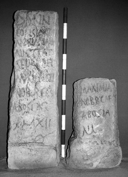
Connected to the Yotvata oasis, three groups of Late Roman milestones, aligned north–south, were discovered in 1994 near Kibbutz Yahel. Each group contained 8–12 complete and broken stones, each bearing Latin inscriptions mentioning emperors from Diocletian to Licinius (293–324 CE). All inscriptions refer to Osia as the “road head” (via caput), from which mileage was counted. On one stone of the middle group, the mileage number XII is preserved, representing the exact distance to the Yotvata fortress. The status of Yotvata on the western side of the Arabah attests to its having served as a regional via caput.
In the ‘Uvda Valley, a vast Nabatean settlement complex has been surveyed by U. Avner. One element consists of over 120 tent camps, 104 of which are concentrated on the eastern side of the valley. Other elements include five circular structures and one public building. The tent camps are 50–200 m long, containing the remains of 10–30 circular tent bases, 3–5 m in diameter. Pottery sherds and other finds indicate occupation of the camps mainly from the second century BCE to the sixth century CE, and during earlier and later periods as well. The circular structures are 10–15 m across and up to 1.6 m high, and yielded surface finds including Nabatean pottery and grinding stones. One structure excavated by R. Cohen did not produce any finds. Also excavated by R. Cohen was the public building (first mentioned by A. Musil in 1902), consisting of two halls, 10.5 by 6.5 and 9 by 5 m. The first contains a row of four square pillars and probably served as an assembly hall. The second contains two long benches to support storage jars. The amount of stone debris inside and outside the building indicates that it originally had two stories. Most of the pottery from the building is dated to the second–third centuries CE, but some is earlier and some later.
Nabatean pottery was also found on most threshing floors of the ‘Uvda Valley (see above), in the cultivated fields, and in the corrals. The Nabatean population of the valley apparently subsisted mainly on agriculture and animal husbandry. The public building implies a socio-economic organization that persisted long after the end of the Nabatean kingdom in 106 CE.
Tent camps, similar to those of ‘Uvda, are found all over the Eilat region, mainly near grazing areas and copper mines. Since Nabatean pottery has been found in copper mines (in the Timna‘ Valley, Naḥal ‘Amram, and others) and in smelting camps (e.g., Be’er Ora), it may be inferred that this population was engaged in copper production. Another type of tent camp was identified, consisting of a row of stone-built, square tent bases, with rounded corners. Sixteen such sites have been recorded to date in the region, with up to 11 tent bases in one site, all built along ancient roads. Their uniform appearance, architecture, and locations imply that they served as military posts guarding the roads to assure the security of commerce. The pottery sherds collected cover a span from the first century BCE to the fourth century CE. Hence, the tent camps appear to have continued in use by Nabateans after the end of their kingdom.
In an excavation by U. Avner of an open sanctuary near Har Shani, undecorated Nabatean pottery was found in a large ash pit, dated by two 14C dates to the sixth century CE. This is one of several indications that the Nabatean population continued to live in the area throughout the Late Roman and Byzantine periods and perhaps into the Early Islamic period.
THE EARLY ISLAMIC PERIOD. Excavations of the Nabatean-Roman-Byzantine town of Aila (by T. Parker) demonstrated continuation of settlement during the Umayyad and Abbasid periods, extending beyond the Byzantine city walls. In addition, a large fortified quarter was built southeast of the town (excavated by D. Whitcomb). It measures 145 by 170 m and is surrounded by a defensive wall preserved to a height of 4.5 m, with four vaulted gates and 24 towers. The inner space has an orthogonal system of streets, with public buildings, architectural monuments (e.g., a tetrapylon), habitation buildings, and shops. The largest building, c. 30 by 50 m, served as a mosque, a madrasa, and a courthouse. Surprisingly, the miḥrab is oriented southwest, an orientation unparalleled in any other ancient mosque. Ancient Arab sources mention several famous teachers who preached in this building during the Umayyad-Abbasid periods. The fortified quarter was first established during the Umayyad period, continued to develop under the Abbasid Caliphate, and became a dense habitation quarter in Fatimid times (see also Jordan, in this volume).
A vast settlement developed in the Eilat region during this period. While a survey of the southeastern Arabah (by A. Smith) yielded only one site besides Aila, the western side of the Arabah is rich in sites of a variety of types: a series of villages, agricultural farms, fortresses, copper mines and smelting camps, gold production sites, and stone quarries.
A chain of six villages was built along the southern Arabah. Three are within the borders of Israel, at Be’er Ora, in Naḥal Sheḥoret, and near Kibbutz Eilot. Three others are located near the gulf shore, in Wadi Taba, Wadi Tweiba, and Wadi Merakh. The largest village was that near Kibbutz Eilot, which originally contained over 30 buildings, most with 3–5 rooms and a courtyard. Three buildings were partially excavated, first in 1971 by R. Cohen. Larger salvage excavations took place prior to the expansion of the Eilat industrial area, in 1989 by Y. Rapuano, and in 1993 by R. Avner. In the village of Be’er Ora, four buildings were excavated in 1999–2002 by Y. Israel, as was a camp northeast of the village. In the latter, a small open-air mosque was uncovered, c. 2 by 2.5 m, with a semi-circular miḥrab on the southern side. In the villages of Wadi Tweiba and Wadi Taba, 22 and 26 buildings respectively were recorded and measured, and a comparatively large building (c. 19 by 21 m) in Wadi Tweiba was partially excavated by R. Avner, consisting of seven rooms, a hall, and a central courtyard. The architecture of all the villages is quite uniform, indicating the involvement of a central (Umayyad) regime. The excavated finds reflect a mixed economy including agriculture, animal husbandry, copper production, seashell ornament manufacture, and possibly other industries.
Two agricultural complexes in the southern Arabah were based on underground qanat water systems, consisting of tunnels and shafts at c. 10 m intervals. At Yotvata, this system replaced the open Nabatean-Byzantine pools. The main system is 4.5 km long, aligned north–south, paralleled in part by an additional tunnel, with several tributary tunnels joining from the west. Another system, c. 2 km long, was built in Naḥal Argaman south of Yotvata. One shaft excavated in 1955 by M. Evenari was found lined with stone masonry. Close to the cultivated fields, which in this period probably covered 1,000 a., open channels were built to distribute water to the plots. The outlines of these are today marked by lines of vegetation.
One of the three fortresses at Yotvata was first identified by Y. Aharoni as Roman-Byzantine, however, excavations by Z. Meshel in 1975 proved it was Early Islamic. It is built of plastered mud-brick walls, 35 by 35 m, with rows of rooms surrounding a square central courtyard. A broad gate was built on the southern side, and a stone staircase in the courtyard led up to the roof or to a second floor. Several buildings were attached to the outer walls and a plastered bathhouse pool was found 100 m to the east. Finds included Umayyad and Abbasid pottery, ostraca fragments, a document written on a camel scapula bone, and a gold coin of al-Mahdi (780 CE). In addition to this fortress, the renewed excavation in the Late Roman fortress (see above) showed that it was rebuilt and occupied during the Early Islamic period. This layer is characterized by well-built, straight mud-brick walls parallel to the main Roman walls.
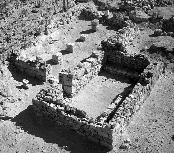
The Evrona Farm was constructed on barren, previously uncultivated land. The qanat system consists of two parallel tunnels with visible surface remains extending for 600 m. An additional section of 500 m was detected by an incomplete ground-penetrating radar survey (U. Basson), but the full length of the system is still unknown. Another branch, 400 m long, joins the main line from the west. Excavations by Y. Porath and U. Avner uncovered several elements: an 18 m section of the eastern tunnel, segments of stone-lined and plastered roofed water channels, a reservoir 17.5 by 13.5 m, and three buildings. The main building is 26 by 29 m, consisting of a central courtyard surrounded by rooms constructed of stone bases with a mud-brick superstructure. The building went through several expansions and changes; one room was converted into a mosque, with a shallow, rectangular niche in the southern wall serving as a miḥrab, oriented towards Mecca. The miḥrab is markedly different and most probably earlier than the semi-circular ones built in mosques after 710 CE.
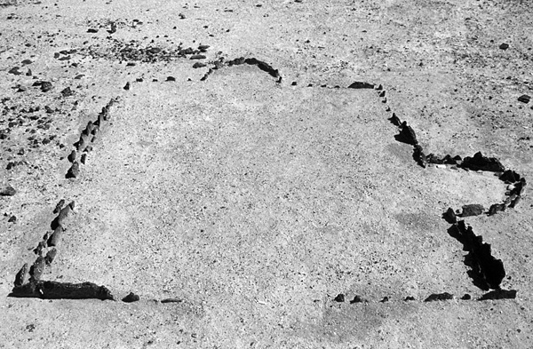
The cultivated field was leveled, cleared of rocks, and surrounded by a stone and mud-brick wall; the western side was protected from flash floods by a rampart. Lines of crisscrossed irrigation channels are still visible in an aerial photograph. At present, only 0.6 a. are preserved, the rest having been washed away by floods, but segments of the protective rampart preserved 1.5 km to the south indicate that the original size of the field was 750 a. or more.
Finds from the excavations, mainly from the central building, include Umayyad and Abbasid pottery, steatite vessels, Umayyad coins, and an ostracon of an administrative document written in old Arabic script. Crop remains include numerous date, olive, and peach pits, almond shells, carob seeds, wheat, and barley.
Copper was mined on a large scale in the Eilat region during the Early Islamic period. Mines are found in Naḥal Ẓfunot, Naḥal Reḥav‘am, and in Jebel Meraḥ (across the Egyptian border), while the largest are located in Naḥal ‘Amram. One of them (surveyed by L. Willies) consists of galleries and chambers totaling 3 km in length. Six smelting camps of the period were identified, characterized by heaps of slag “cakes,” resulting from tapping technology. The largest camp, located near Be’er Ora, contained c. 5,000 tons of slag, representing the production of 300–500 tons of copper. Three furnaces were excavated here by B. Rothenberg. The Naḥal ‘Amram mines and the smelting camp of Be’er Ora were first operated during the Nabatean period (based on collected pottery). They were also in use during the Mameluke period (based on 14C dates), but their main period of activity was in the Early Islamic period (based on both pottery and 14C dates).
Two religious structures were also excavated in the Be’er Ora smelting camp. One is rectangular, 6.4 by 5.7 m, and marked by slag slabs set vertically into the ground, with two semi-circular niches on the east and south. In 1969, B. Rothenberg excavated probes in the structure and suggested it was a symbolic church. Following an additional excavation in 1992 (by M. Sharon, U. Avner, and D. Nachlieli), it was suggested that the structure was initially an open mosque with a niche on the eastern side, indicating the original, eastern qibla (prayer orientation) of incipient Islam. The southern niche, the miḥrab, oriented toward Mecca, would have been added as a result of ‘Abd al-Malik’s reform at the very end of the seventh century CE. Today, this interpretation faces difficulties for two main reasons. Studies of early mosques in Jordan (by R. Schick) demonstrate that the semi-circular miḥrab first appeared later, in the early eighth century CE, and therefore, the eastern niche at Be’er Ora cannot represent an early, eastward-facing miḥrab. Second, the silt layer, in which the slag slabs were inserted, was dated by five 14C dates from the seventh to eleventh centuries CE, which means a late date for the entire structure. Thus, it seems that the structure served both Islamic and Christian workers for prayer, a possibility supported by ample Arab written sources. The other structure is smaller, 4 by 3.5 m, with a triad of slag slabs set vertically on the eastern side, in the same manner as maṣṣebot, and a single slag slab set on the southern side. Two 14C dates from thin ash layers were of the early tenth and late thirteenth centuries CE.
In the Timna‘ Valley, no evidence of Early Islamic copper mining has been discovered, however, the typical slag “cakes” are found in several second millennium BCE smelting camps. One furnace excavated by B. Rothenberg in site 2 was dated to the Early Islamic period by 14C tests.
Two gold production sites are known to date in the Eilat mountains, one in Wadi Tawaḥin and the other 2 km farther north. The former was first discovered by F. Frank in 1933 and was interpreted as a factory for production of barite (BaSO4). In 1988–1990 a geological survey by A. Gilat, M. Shirav, R. Bogoch, and L. Halicz, and an excavation by U. Avner and D. Nahlieli, revealed that it was a gold production site. It consists of 17 sub-sites along some 800 m of the wadi, with the remains of at least 15 buildings, 8 stone installations, 23 tent bases, a small cemetery, and a diorite-stone quarry for the manufacture of millstones. On the surface, 32 lower millstones were found, fragments of lower and upper millstones, 45 stone anvils, and dozens of hammer stones of various types and sizes. Gold, up to 9 PPM (9 g per ton), was detected in the valley by many chemical analyses, sampled mainly from the alluvial terraces.
In building XI, two lower millstones were initially visible and two more were uncovered during the excavation. In three adjacent installations, pairs of stone anvils were found, two different types in each. A fine white-pink powder found around the millstones and the anvils contained 20–29 PPM gold dust. Based on the remains, which have parallels in northern Hejaz and in the eastern desert of Egypt, the following scenario of gold production is offered. Quartz gravel bearing gold was dug out and sifted from the alluvial terraces along the wadi, crushed on anvils by means of hammer stones and milled into a fine powder on the millstones. No indication of the refining process was found at the site, but this was described by al-Hamadani in the tenth century CE. The powder was mixed with water in V-shaped wooden troughs and rotated repeatedly. The most concentrated material was then mixed with mercury, which either consumed or floated the contaminants, leaving only the gold. This was sifted and roasted until only the purified gold dust remained. Due to the need for water, this process most probably took place on the gulf shore, 5 km from the site. Based on pottery and 14C dates, the site was exploited during the eighth–tenth centuries CE.
After visiting Wadi Tawaḥin, F. Frank also discovered a large limestone quarry in Naḥal Roded, popularly known today as the “Lost City.” The site covers an area of 400 by 150 m and contains dwelling rooms for the workers with alleys between them, built from the stone debitage. Several crosses and two pigeons are incised and painted on the walls of one structure. In 1975, Z. Meshel excavated probes at the site, dating it to the Byzantine period, however it appears that the vast majority of the pottery is Early Islamic and the stone was most probably cut for construction of the fortified quarter of Aila.
The Early Islamic period settlement came to an end when two intense earthquakes struck the area, in 1068 and 1071 CE. When the Crusaders arrived in 1115, Aila was only a village and the hinterland sites were abandoned.
THE CRUSADER AND MAMELUKE PERIODS. Although events in the area during the twelfth century CE were recorded by Arab and French writers, no Crusader remains have been identified to date in the Eilat region. Mameluke activity is known from the smelting camp of Be’er Ora and from copper mines of Naḥal ‘Amram and the Timna‘ Valley; in the latter two, stone buildings were erected next to mining areas. Intensive activity took place along the Darb al-Ḥajj, the Muslim pilgrimage road to Mecca. Sections of the road itself are preserved today between the Netafim pass on the Egyptian border and Eilat, including ‘Aqabat Aila (the Aila ascent). Some sections were cut into the rock, with large curbstones laid along them; others were carefully marked by smaller curbstones; some were later paved with stone. A bridge was built across Naḥal Shlomo (Wadi Masri). Several camps were built along the road between Ras en-Naqb and Naḥal Shlomo; they contain well-built circular bases for tents, well-constructed buildings, and simple wind shelters. Several fragments of Mameluke inscriptions were found in the camps, while two complete ones are now lost. One was an inscription of Qansawh al-Ghuri (c. 1500 CE), found by L. Woolley and T. E. Lawrence near the bridge; the other, of Hassan Nassar and Muhammad Qalawun (1355 CE), was found by B. Rothenberg at Ras en-Naqb. The Ḥajj road served caravans from Spain, North Africa, and Egypt. Another road led the pilgrims from the northeastern parts of the Islamic empire, through Damascus, and both roads joined at Aila (‘Aqaba).
Excavations on Pharoah Island (Jazirat Fara‘un), south of Taba, by A. Goren (unpublished) yielded ample artifacts dated to the late Ayyubid and early Mameluke periods. These included some 1,500 textile fragments, many of them dyed, 1,400 basketry and cordage fragments, pottery, metal fragments, food remains, and dozens of paper fragments and Mameluke letters. One coin of Amalric may attest to a Crusader presence on the island, and a coin of Baibars serves as one of the indications for the construction of the fortress on the island’s hills during the Mameluke period. The finds indicate that Pharoah Island served as a military position and an international entrepot.
In 1516 the area came under Ottoman control. The Ḥajj caravans and maintenance of the road continued and a garrison held the Mameluke-Ottoman fortress of Aila. The rest of the area was practically dominated by the Bedouin population.
UZI AVNER
Color Plates
Introduction
The Eilat region is arbitrarily defined as the southern tip of modern Israel, from the Shizafon junction in the north to Eilat in the south. The area is hyper-arid, with an annual average rainfall of only 28 mm, an annual potential evaporation rate of 4,000 mm, and summer mid-day temperatures reaching over 40 degrees C. As a result, perennial water sources are rare, the Saharo-Arabian vegetation is restricted to the wadi beds, and the carrying capacity for animal and man is low. The landscape varies and changes abruptly, with mountains up to 892 m above sea level, broad valleys (‘Uvda, Sayarim, and Se‘ifim), the deep Arabah, and the shores of the Gulf of ‘Aqaba. The lithology is also rich and variegated, with igneous and metamorphic rocks, sandstone, and limestone.
Given these environmental conditions, the site density and settlement pattern of the area is surprising. Ancient sites have been recorded in the region since 1861, but more detailed study began in the early twentieth century with the surveys of A. Musil, F. Frank, and N. Glueck, followed by the survey of B. Rothenberg during the 1960s. Further surveys have been conducted since 1978, mainly in preparation for the redeployment of the Israel Defense Forces from Sinai and prior to various development projects. To date, only c. 7 percent of the area has been covered by a detailed archaeological survey, and c. 1,500 ancient sites have been recorded in an area of 1,200 sq km. These sites represent a continuous sequence of settlement over the past 10,000 years, in contrast to a pattern of alternating periods of settlement and abandonment as revealed in the Negev Highlands and in Sinai. The main factors that influenced the region’s history were the copper and other mineral resources, the ancient international roads that crossed the area, and its geopolitical and strategic position. These resulted in a settlement density that defies the environmental conditions.