
EXCAVATIONS WITHIN THE ANCIENT CITY
1. THE CITY OF DAVID VISITORS’ CENTER
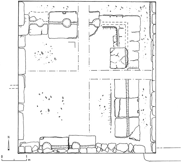
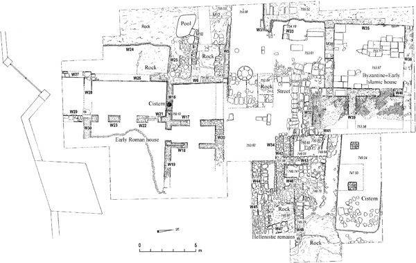
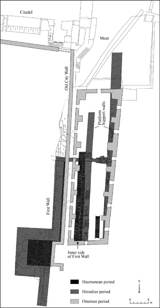
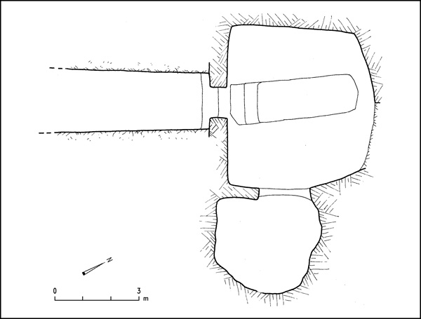
In 2005, excavations were conducted in the area of the visitors’ center on the northern part of the southeastern hill of ancient Jerusalem, identified with the biblical City of David. The excavations were directed by E. Mazar, on behalf of the Shalem Center and the Hebrew University of Jerusalem. The area had largely been excavated in 1923–1925 by J. G. Duncan and R. A. S. Macalister. It is located several meters northwest of the Stepped Stone Structure uncovered on the northeastern slope of the hill (Shiloh’s area G).
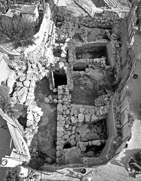
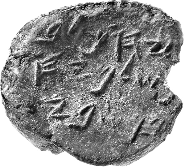
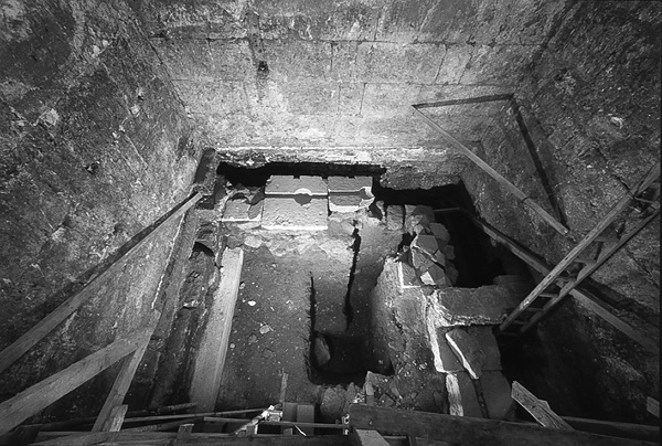
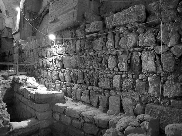
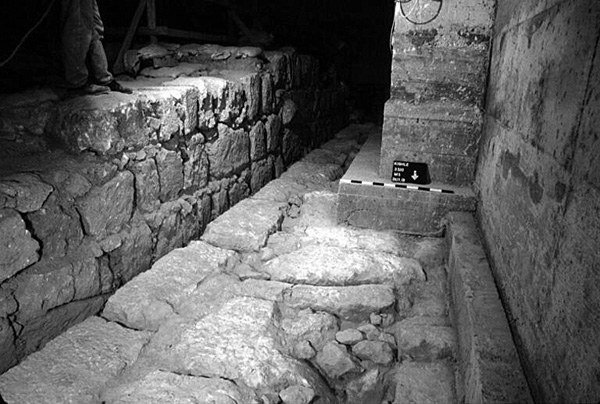
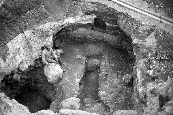
In the Middle Bronze Age, an open flat area was created in the area by the quarrying of bedrock and the depositing of fills of crushed limestone. Above this surface was an earth accumulation containing Middle Bronze Age, Late Bronze Age, and Iron Age I sherds. At an early stage in the Iron Age IIA (the tenth century BCE), a structure built of very large stones, referred to as the Large Stone Structure, was erected in this location. Its massive walls, 2.0–5.0 m wide, consist of particularly large untrimmed stones, and extend over the entire excavation area and even beyond it. The Stepped Stone Structure and Large Stone Structure appear to constitute a single architectural unit, the former built as a support system for the latter. In the opinion of E. Mazar, this construction was overseen by King David, having been erected outside the city wall and the citadel at the high northern end of the City of David, perhaps the biblical Citadel of Zion. The ashlars and Proto-Aeolic capital found by K. Kenyon in adjacent collapses to the east (her square A/XVIII) probably originated in this building. In one room in the northeastern part of the Large Stone Structure was found evidence for two secondary construction phases dated to a subsequent phase in the Iron Age IIA. A bulla bearing Paleo-Hebrew script, reading “Belonging to Yehuchal, son of Shelemiyahu, son of Shovi” was found in the excavations. An individual by this name held an important position during the reign of King Zedekiah, as mentioned in Jeremiah 37:3 and 38:1. The building remained in use until the end of the Iron Age.
A few remains from later periods were found in the excavations. From the Herodian period are plastered pools and a mikveh dug into building remains of the Iron Age and incorporating large stones from a previous construction. From the Byzantine period was uncovered a room paved in white mosaic, part of a house with a peristyle courtyard largely exposed by Macalister and Duncan and referred to by them as the House of Eusebius. The latest of the remains found in the excavation area is a pit that contained Abbasid (tenth-century
EILAT MAZAR
2. THE GIHON SPRING AND EASTERN SLOPE OF THE CITY OF DAVID
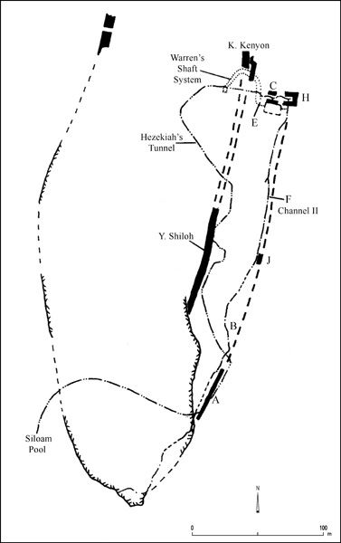
Renewed excavations took place in the area of the Gihon Spring and the lower Kidron Valley, on the eastern slope of the southeastern hill of ancient Jerusalem. The excavations were conducted in 1995–2004 by R. Reich and E. Shukron on behalf of the Israel Antiquities Authority. Some of the new excavation areas adjoined ones previously excavated. Others were in areas that had not been explored.
CHALCOLITHIC PERIOD AND EARLY BRONZE AGE FINDS. The earliest pottery sherds were found in area B, which adjoins Y. Shiloh’s areas B and D1. In the rock crevices under the Iron Age II houses were several handfuls of Chalcolithic period and Early Bronze Age I pottery sherds. Pottery of the Early Bronze Age I was also found inside the southern cave of the Warren’s Shaft complex, indicating that it served as a dwelling during that period.
MIDDLE BRONZE AGE II REMAINS. The main excavation area lay south and west of the Gihon Spring (area C). This area had never been excavated.
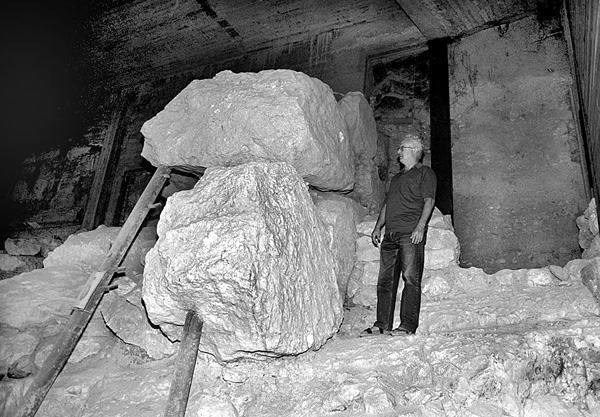
The Spring Tower. The recent excavations exposed a monumental, rectangular-shaped structure built around the spring to protect it. This has been named the Spring Tower. Its southern wall was exposed in its entirety. The tower’s external dimensions are 17 by 16 m, with a room c. 10 by 5 m in its interior. The eastern wall of the tower rests on the Kidron Valley bed. Remains of its eastern and western faces indicate walls c. 7 m thick. The tower abuts a rock-cut step on the west. Similar to the Pool Tower exposed further to the west, the Spring Tower incorporates large boulders with average dimensions of 1.5 by 1.2 by 1 m, and an average weight of 3–4 tons. A 3.2-m-long stone was exposed in the inner face of its western wall. This is the largest construction known in Jerusalem prior to the Herodian masonry of the first century BCE. Although these boulders are quite rough, having simply been dislodged from the rock terraces of the hill, they are set in courses to form straight vertical faces.
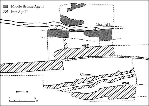
Channel II. As a separate technical phase preceding the construction of the Spring Tower, channel II, which carries the spring water southward, was cut into the eastern slope of the Kidron Valley. The first segment of channel II was partly uncovered by C. Schick in 1886 and 1890. Other scholars who excavated parts of it or reexamined known segments were M. Parker (1909–1911), R. Weill (1913–1914), and Y. Shiloh (1978–1985). From 1995 to 2001, R. Reich and E. Shukron exposed three other portions of the channel. The first is its entire northern segment, extending from the spring for a distance of 130 m to the south (area F; the first roughly 65 m of this segment had been previously examined by Parker). The second is a point 190 m south of the spring where the channel becomes a quarried tunnel; excavations ensued from this point northward for a distance of 13 m. The third is a 32-m-long tunnel segment of the channel, excavated c. 280 m south of the spring (area A).
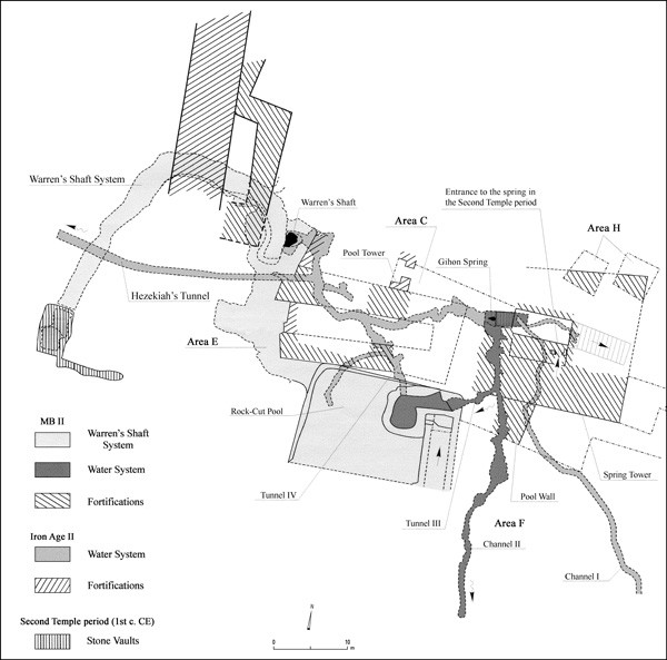
The depth of the channel varies according to the level of the rock surface. In some places it is as much as 5 m deep. Since the southern wall of the Spring Tower is built over the covered channel, the channel is most probably contemporary with the Middle Bronze Age II water system. Previously, the channel, which is elsewhere referred to as the Siloam Tunnel, had been regarded as separate from the other waterworks of the City of David. As a result of the findings of the new excavations, the excavators now consider the northern part of channel II—that extending 190 m southward from the spring—to have been an integral part of the Warren’s Shaft system, created to feed the Rock-Cut Pool. The entire water system, including channel II, is thus dated to the Middle Bronze Age II. Excavation at the point of transition from the covered channel to the tunneled channel revealed that originally the covered channel turned sharply to the east at this point while the tunnel appears to be a later prolongation of the channel dating to the late Iron Age II.
The Rock-Cut Pool. Southwest of the Gihon Spring is an extremely large pool cut into the hard mizzi
The Pool Tower. Abutting the northern side of the pool is another monumental construction. It has two thick parallel walls constructed of huge boulders, leaving a narrow space between them. The eastern edges of these walls were later discovered inside the caves at the southern end of the Warren’s Shaft system. Middle Bronze II pottery was retrieved above and under the floor in this space. Another floor which contained such pottery was located at the junction of the Warren’s Shaft system and the northwestern corner of the pool. Additional Middle Bronze II pottery, a scarab, and a scarab impression on a storage jar sherd were found associated with the thick walls and the rock surface upon which the walls rest.
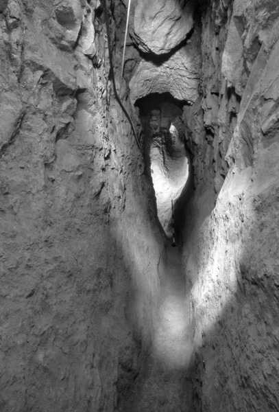
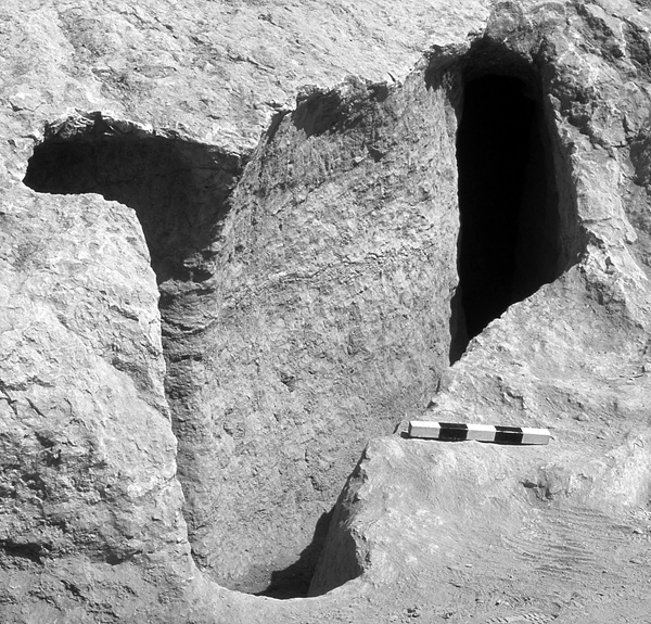
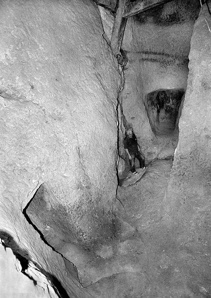
The Warren’s Shaft System. These findings prompted a reexamination of the Warren’s Shaft system, which was discovered by C. Warren (1867), excavated by M. Parker and L. Vincent (1909–1911), and reexamined by Y. Shiloh (1978–1985). The renewed excavations and examination of the system (area E) took place in the two caves at its southern and lower end: the southern cave, which connects the system to the Rock-Cut Pool; and the northern cave, which is above Warren’s Shaft. The rocky floor of the southern cave and a small niche within it produced Early Bronze I pottery of the type already discovered by Parker and Vincent, which attests that these originally were Early Bronze Age dwelling caves. A crushed limestone floor was exposed at a higher level; Middle Bronze Age II pottery was retrieved from above and below the floor. A roughly 0.5-m-thick layer of stonecutters’ waste consisting exclusively of hard mizzi rock was encountered overlying the layer with Middle Bronze Age II pottery. It contained three oil lamps of the eighth century BCE.

Bedrock in this area is clearly divided into two distinct rock formations—an upper layer of soft meleke resting above a lower, hard mizzi layer. It had previously been commonly held that the Warren’s Shaft system was created when an existing, long and winding natural cavity in the bedrock was enlarged. According to this theory, the tunnel was cut in a single operation through both upper and lower rock formations to reach the vertical natural cavity located at its end. The renewed excavations and subsequent study by Reich and Shukron have led to a new theory regarding the system, which holds that the entire system was cut in two phases rather than one. In the original phase, the tunnel was cut exclusively into the upper, softer rock layer; the hard rock layer below served as the tunnel floor. This tunnel reaches the southern cave and emerges at the Rock-Cut Pool. It dates to the Middle Bronze Age II, together with the Spring Tower, Pool Tower, Rock-Cut Pool, and channel II. In this phase, the vertical Warren’s Shaft, a natural dissolution chimney (as demonstrated by D. Gil’s geological examination), had not yet been encountered, as it does not reach the top of the hard stone formation. It was thus inaccessible and played no part in the original system. In the second phase, which dates to the eighth century BCE, the tunnel was deepened for unknown reasons, penetrating the hard rock layer below. It was then that the natural shaft was first discovered. This deepening also hindered free access to the Rock-Cut Pool. The water supply to the city does not appear to have been hindered at this point, as it had come to largely depend on Hezekiah’s Tunnel, which was also cut in this period.
No pottery sherds of the Late Bronze Age or the Iron Age I were encountered in the areas excavated near the spring (areas C, E, H). This may be relevant to the debate on the character of Jerusalem during these periods, though it must be added that no sherds from the Persian, Early Hellenistic, Byzantine, and Early Islamic periods have been found near the spring either.
IRON AGE II REMAINS. Area C. In several places, the monumental towers and the Rock-Cut Pool were covered with debris containing eighth-century BCE pottery. Repairs made with smaller stones were observed in some places, such as on the southern wall of the Spring Tower. It seems that the Warren’s Shaft system of the Middle Bronze II was accessible and continued in its original use into the late Iron Age. During this period the openings of the two caves at the eastern edge of the Warren’s Shaft system were blocked with a wall of small stones. Outside one of these walls and abutting the northern face of the Pool Tower was a room, and near the blocked opening of the northern cave was a floor containing two groups of dried-mud loom weights typical of the Iron Age II, as well as charred wood. This evidence suggests that during the late Iron Age II the passages connecting the Rock-Cut Pool and horizontal tunnel were blocked and the inner parts of the Warren’s Shaft system, as well as the area outside of it, were used as dwellings.
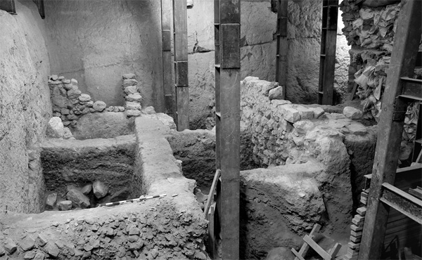
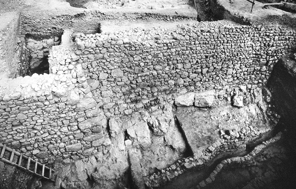
Channel I, originally discovered by E. Masterman in 1901, was recleared at the bottom of the present-day fountain house standing over the spring. It runs a winding southward course. It should be dated to the Iron Age II, as established by another segment of it exposed in areas A and J. Its function remains unclear. At the easternmost point of area C, close to the lowest level of the Kidron Valley, a c. 2-m-wide segment of the city wall, constructed of small stones and preserved to a height of at least 6 m, was encountered. Pottery extracted from the earth abutting its eastern face dates its latest use to the eighth century BCE; its foundation trench was not reached during excavations.
Area J. The city wall revealed in area C probably joins the 2-m-wide wall uncovered in area J (wall 501), preserved to a height of over 5 m. The wall is built of small fieldstones and is founded on bedrock. A segment c. 35 m long was traced in the area, including a sizeable offset constructed of large stones. The pottery from the earth deposit over the wall, as well as that abutting its western side, dates to the eighth century BCE. Two similar walls were revealed running parallel to this wall, one several meters to its east and the other a similar distance to its west. A segment of channel I, clearly dated here to the eighth century BCE, was exposed between the central and eastern walls, at a lower level than channel II. The eastern wall was founded very close to the bed of the Kidron Valley.
These constructions seem to reflect the addition of a modestly sized area, c. 1.5 a. at the most, to the city in the eighth century BCE. It likely accommodated the natural growth of Jerusalem. While the city experienced a considerable westward expansion in the eighth century, as evidenced by the N. Avigad excavations in the Jewish Quarter, this eastward fortified expansion may have been earlier. It is perhaps identifiable with the area referred to in the Bible as “between the walls” (Is. 22:11; Jer. 39:4, 52:7).
Area A. Excavations along the Kidron Valley bed, c. 200–250 m south of the spring, revealed the eastern face of a long wall constructed of small fieldstones and founded on bedrock. Its precise thickness could not be established, but it clearly is a southern continuation of the eighth-century BCE city wall exposed in area J. Along the eastern, extramural face of this wall ran a rock-cut channel, several cover stones from which survived. According to its location in relation to the wall and to its bottom levels, it appears to be part of channel I. In this spot, as in area J, the channel was dated on the basis of pottery to the eighth century BCE.
Area B. Excavations in area B, an extension of Y. Shiloh’s areas B and D1, revealed the remains of three private houses of the eighth century BCE. The houses are built upon a rock terrace, their western parts hewn into bedrock, their eastern parts raised upon retaining walls. In addition to pottery, concentrations of dried-mud loom weights typical of the period were retrieved. Other private houses had been revealed in this area during excavations by Shiloh, who argued that they were part of an extra-mural quarter, located below the city wall that he exposed at mid-slope. However, as the houses are contemporary with the city wall segments recently exposed by Reich and Shukron at the foot of the slope, they should be understood as always having been intra-mural. The houses excavated by both expeditions are oriented along a north–south axis, indicating a planned quarter.
PERSIAN PERIOD FINDS. No pottery of the Persian or Early Hellenistic periods was found in the vicinity of the spring. In area A, c. 240 m south of the spring, some earthen deposits, dumped from the eastern slope of the City of David to the Kidron Valley, contained Persian period pottery including several jar handles with yhd seal impressions.
THE HERODIAN PERIOD CITY DUMP AND OTHER REMAINS. Each of the areas excavated on the eastern slope of the southeastern hill contained an extremely thick (8–10 m) deposit of loose earth, rubble, large amounts of broken pottery, stone vessels, animal bones, and other finds. This accumulation of debris covers the entire length and width of the slope, extending northward to the southeastern corner of the Temple Mount. There were no walls associated with the debris. The artifacts recovered from it date mainly to the first centuries BCE and CE, up to the year 66 CE; no coins of the First Jewish Revolt were found.
The accumulation had been previously encountered and described by all past excavators of the eastern slope of the southeastern hill, including Warren, Schick, Parker, Macalister, Kenyon, and Shiloh. It should be identified as the city dump of the Herodian period. Containing at least 200,000 cu m of material, it seems to have been the result of an organized and continuous effort to deposit waste material in this area of the city, which had previously served as a city dump in the Iron Age and Persian periods. As this dumping activity was potentially hazardous to the spring and might have blocked access to it, some unsuccessful, simple terrace walls were constructed close to the spring to prevent the garbage from sliding down the slope. Once this proved ineffective, a barrel-shaped stone vault was built above the spring; the vault still survives as the inner part of the fountain house. Its first-century CE date is attested by pottery covering its extrados.
In the late Second Temple period, the space within the Spring Tower was refurbished as a fountain house. Surviving from this structure are its doorway, built of well-cut ashlars, and the remains of several stone steps descending to the spring. The approach to the spring and its protection would have been necessary measures given the specific cultic uses of the spring water in the temple.
A concentration of several scores of intact cooking pots, in several layers, was discovered in area A, east of the Iron Age II wall. It appears to be one of several such concentrations already known from other locations around the city’s perimeter. The vessels are of the types prevailing in the late second–first centuries BCE. Several isolated cooking pots were also found in area J.
LATE ROMAN AND BYZANTINE REMAINS. Considerable quantities of Late Roman period pottery sherds were found in areas H and C in the vicinity of the spring. The pottery predominantly includes storage jars and deep kraters with flaring rims. Roof tiles, one bearing a seal impression of the Tenth Roman Legion, were also recovered. These finds were deposited between several thin layers (c. 20 cm each) of fine-grained silt or clay. Remains of an earthen dam incorporating several boulders taken from the adjacent Middle Bronze Age II Spring Tower were found in area C. It extended eastward across the Kidron Valley from the Spring Tower. This dam held back rainwater and silt, perhaps for agricultural purposes or for obtaining clay for pottery production. The level of the uppermost silt layer is higher than the apex of the vault above the spring, indicating that access to the spring was blocked during this period. It was not reopened until the Mameluke period.
No Byzantine or Early Islamic pottery was found in the areas excavated near the spring, as access to the spring was blocked in the Late Roman period and activity had moved to the Pool of Siloam at the southern end of the hill. A small excavation on the southern side of the hill, near the Meyuhas House (area D), exposed part of an ancient quarry. Several coins found in this spot indicate that the quarry dates to no later than the late Byzantine period.
MAMELUKE PERIOD REMAINS. Mameluke period (c. fourteenth-century
RONNY REICH, ELI SHUKRON
3. THE POOL OF SILOAM
In 2004, the remains of a large stepped pool were found on the eastern side of Birkat
Construction of the first phase of the pool is securely dated to the mid-first century BCE on the basis of several coins embedded in the plaster. The second phase dates to the first century CE. Considerable amounts of pottery sherds and 12 coins of the First Jewish Revolt date the abandonment of the pool to the year 70 CE, followed by a process of rapid silting. The pool should thus be identified with the late Second Temple period Pool of Siloam, which appears in historical sources (Jn. 9:7). The Byzantine period Pool of Siloam was constructed further to the north, near the outlet of Hezekiah’s Tunnel.
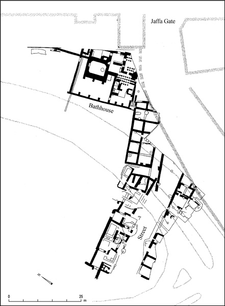
4. THE GIV‘ATI PARKING LOT
An excavation was begun in 2003 in the Tyropoeon Valley, to the southeast of the Dung Gate, under the direction of E. Shukron and R. Reich and on behalf of the Israel Antiquities Authority. The site lies west of areas excavated by R. A. S. Macalister and J. G. Duncan in 1923–1925, and north of areas excavated by J. W. Crowfoot and G. M. Fitzgerald in 1927.
A small amount of late Iron Age II pottery was encountered in the excavations. The earliest architectural remains, however, date to the late Second Temple period. These include a partially preserved stone vault, which abuts an earlier, as yet undated wall built of large stones; the lower part of a stepped, plastered mikveh; and remains of a floor and walls dated to the second century BCE.
Two main phases dated to the Byzantine period were identified. Constructed in the earlier of the two were long east–west walls with deep foundations. Beaten earth or plain tessellated floors were associated with them. A typical Byzantine period cistern supported by arches was constructed between the main walls and plastered with a mixture containing worn pottery sherds. During the later phase, some of the walls were severed on the east to create space for a stone-paved alley. No traces of destruction were found and the area appears to have been abandoned at the end of this phase.
The Early Islamic period stratum was encountered only in the eastern part of the excavated area. It included walls incorporating building stones from previous strata. An extraordinary find from this stratum is a small marble fragment with the remains of a Hebrew inscription mentioning bar ya‘[aqov], “son of Jacob.” The find supports the identification of this part of Jerusalem as a neighborhood inhabited by Jews during this period, as attested in historical sources. The very thick upper layer (c. 4–5 m) encountered in the excavation area was devoid of construction remains. Its deposition began in medieval times, when the area was abandoned.
5. THE DUNG GATE AREA
Remains of the Secondary (Eastern) Cardo were uncovered on the western edges of an excavation area located within the present-day Old City walls just west of Dung Gate, below the escarpment at the eastern side of the Jewish Quarter. The excavation was conducted by R. Reich, Y. Billig, and Y. Baruch on behalf of the Israel Antiquities Authority. Small segments of this street had previously been excavated by C. Warren (1867), C. N. Johns (1930s), and M. Ben-Dov (1980). Some of the street’s features—a drain under the paving in the middle of the street, the laying of the thick flagstones diagonal to the street’s axis, and the shape of the adjacent column bases—differ considerably from those of the Cardo, which was exposed in the Jewish Quarter. It appears to have been paved during the Late Roman period and remained in use through the Byzantine period. In the Early Islamic period, Umayyad palace III was erected along its eastern side. The southern continuation of this street outside the present-day Old City wall was excavated by M. Ben-Dov.
Considerable portions of the Umayyad palaces were first exposed by the B. Mazar expedition. R. Reich, Y. Billig, and Y. Baruch have extended the excavation of palace III (as referred to by the B. Mazar expedition), which lies southwest of the Temple Mount, next to the Dung Gate. A large part of the southern side of palace III was exposed, as was its western wall, which abuts the Secondary Cardo. It turned out to be a far larger edifice than the Mazar expedition realized, measuring 79 by 75 m. From a western gate opening onto the Secondary Cardo, one enters a wide, paved corridor bisecting the western wing of the building and leading to the inner courtyard. Entrances from this corridor lead to the north and south. The southwestern part of the building (c. 27 by 35 m) was also cleared in the excavations. It contained four rows of five large rectangular piers that apparently supported groin vaults. Part of the stylobate of the colonnades that stood around the inner courtyard were encountered north of and parallel to the southern wing of the palace.
Four long, narrow spaces were excavated in the southeastern quarter. Two wider spaces in this area of the palace had previously been excavated by the B. Mazar expedition (1968–1978). Its foundations reach a considerable depth. (The W. Davidson Visitors’ Center was constructed in these spaces.) Between the thick, c. 2.5-m-wide walls, the excavation descended only 6–9 m below the floor level of the main palace, a small part of which had been exposed by B. Mazar. Bedrock was found, by boring, to lie considerably deeper. The spaces between the exposed walls in this area, which are at the foundation level of the building, were filled with carefully laid beds of earth and gravel. This bedding raised the level of the terrain, creating broad, horizontal spaces for the floors of this and the adjacent large buildings, all erected on a naturally sloping area. The earth fills contain fragments of various artifacts and coins, the latest dating to the late Byzantine and Early Islamic periods.
The uppermost stratum over the entire area northwest of Dung Gate comprised a residential zone of small houses constructed of thin walls of fieldstone. In the houses were many small, rectangular vats lined with high-quality hydraulic plaster. The small finds, particularly the large amount of pottery found within the houses, are characteristic of the Mameluke period. Installations related to an unknown craft were also present.
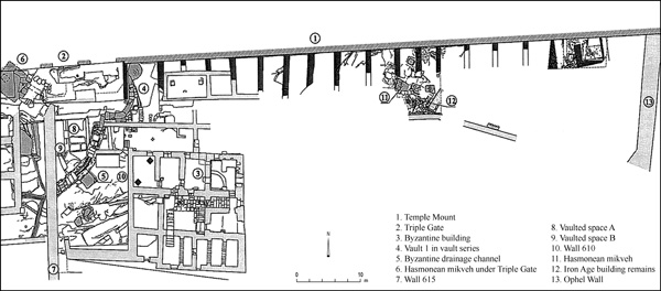
6. THE HULDAH GATES AREA
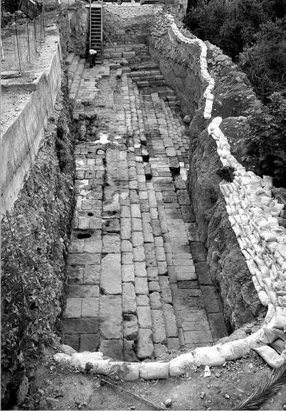
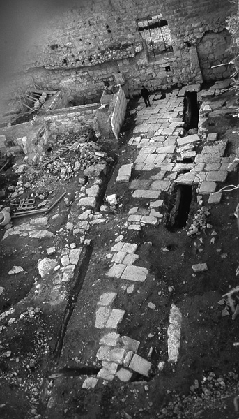
During a tourism development project in the Huldah Gates area, along the southern wall of the Temple Mount, some probes were made by Y. Baruch and R. Reich in 1997–1999 on behalf of the Israel Antiquities Authority. The greater part of this area had been exposed by the B. Mazar expedition. The principal findings in the vicinity of the Triple Gate predate Herod’s enlargement of the Temple Mount. The entrance chamber to the large mikveh underlying the gate was exposed; the rock-cut steps descending into the mikveh were found to have a rock-cut partition down the middle of the steps. Next to the mikveh, a staircase ascends from southwest to northeast; it was partly rock-cut and partly constructed of flagstones.
The excavations reexamined the rock-cut vaults and spaces south of the Triple Gate, upon which the monumental Herodian staircase ascended to the gate. Several stone stair treads and part of a handrail from this staircase were found in secondary use in a nearby Byzantine period building excavated by B. Mazar. The dismantling of a small segment of the easternmost wall of Umayyad palace V yielded several spolia from the Herodian Royal Stoa. These include large column bases and drums, c. 1.0 m in diameter, and a large cornice decorated with rosettes and swastikas.
A small probe was sunk at the southern wall of the Temple Mount, c. 10 m west of the southeastern corner of the enclosure. Some wall fragments, floors, and pottery sherds dated to the late Iron Age II were uncovered, as were a few walls and a mikveh shown to have been damaged when the massive Herodian southern wall of the Temple Mount was constructed.
RONNY REICH
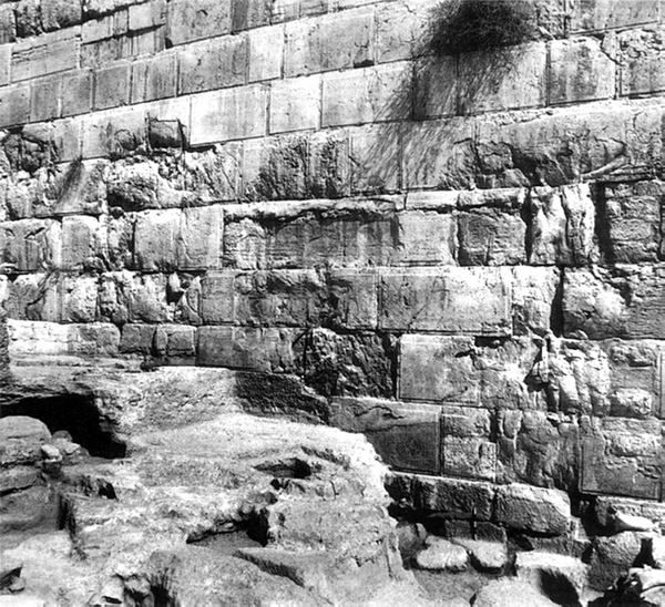
7. THE ROBINSON’S ARCH AREA
In 1994–1996, excavations were resumed in the Robinson’s Arch area, the first since the conclusion of the large-scale excavations in this area directed by B. Mazar. The renewed excavations were directed by R. Reich and Y. Billig, on behalf of the Israel Antiquities Authority.
The main architectural remains exposed west of the southwestern corner of the Temple Mount, which had been partially exposed by C. Wilson (1865), C. Warren (1867), and B. Mazar, consist of a 70-m-long segment of the paved Herodian street and the façade of the pier of Robinson’s Arch. The street runs along the western wall of the Temple Mount. It is paved with large, well-cut stone slabs of various sizes, the largest 3.20 m long, laid in no apparent pattern. The stone slabs are 25–40 cm thick. All the stones were found intact and in situ, except in one spot where the impact of the collapse of Robinson’s Arch severely damaged the street. The width of the street between two raised curbs is c. 8.5 m.
A date for the construction of the street was established in the excavations. A probe under one of the flagstones of the street revealed several coins, the latest of which dates to Pontius Pilate (26–36 CE; an additional coin from 67 CE seems to be intrusive). It seems that, although the street was planned as part of Herod’s building program on the Temple Mount, it was paved only in the last generation before the destruction of Jerusalem in 70 CE. This also accounts for the unweathered state of the street’s flagstones.
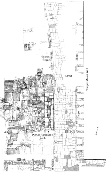
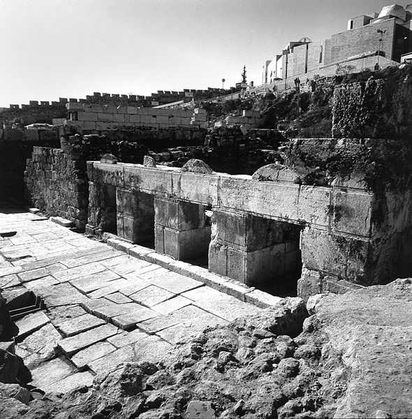
The street does not abut the western wall of the Temple Mount, but runs parallel to it at a distance of c. 3 m, leaving a space in which a row of small chambers was constructed. These chambers, 21 of which were identified, have uniform measurements of c. 3 by 3 m. They opened onto the street, and most probably served as shops, though they were found almost completely devoid of artifacts. Similar chambers were situated on the western side of the street, four of which were located in the pier of Robinson’s Arch; these were excavated by B. Mazar. The street apparently served as the main commercial thoroughfare in the city.
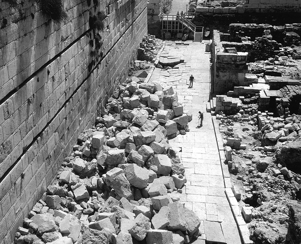
The street’s pavement was found covered with a thin (3–5-cm-thick) layer of debris containing pottery sherds, animal bones, and some 130 coins, having accumulated once the street was no longer cleaned and maintained. The latest coin is of the fourth year of the First Jewish Revolt against Rome (69
The dismantling of the eastern wall of Umayyad palace IV, adjacent to the southwestern corner of the Temple Mount, revealed that it incorporated parts of a Roman building, most probably a latrine. Parts of this latrine had been exposed by the B. Mazar expedition. A dozen flat stones of the presumed latrine bear carved decorations and inscriptions, allowing for their identification as spolia originally used as seats of a theater or some other public assembly hall. These stones were then incorporated into Umayyad palace IV. There is no evidence for the date of construction of the theater or its location, though it must have been in close proximity. It may have been the theater said to have been built by Herod, or the one constructed for the Roman city of Aelia Capitolina.
An intact, inscribed milestone bearing the names of Vespasian and Titus, as well as that of the Tenth Roman Legion, was found in secondary use in Umayyad palace II, south of the Temple Mount. The name of the legate was completely erased. The Romans fashioned the milestone from one of the rounded handrail stones from the monumental staircase that led over Robinson’s Arch. This provides evidence that the handrail, and perhaps the entire arch, was destroyed no later than 79 CE. An identical inscription, albeit fragmentary, was discovered in this area by the B. Mazar expedition.
A small cemetery exposed along the western wall of the Temple Mount appears to have been in use in medieval times. The B. Mazar expedition encountered its earliest burials, which date to no later than 1099 CE. Now more than 30 additional burials have been revealed. The diversity of burial practices in this cemetery may suggest various ethnic groups, interred over a considerable length of time. A Hebrew inscription citing Isaiah 66:14 was discovered by B. Mazar on one of the stones of the western wall. Mazar dated it to the mid-fourth century CE, the days of Julian the Apostate. However, it may now be understood as having been directly related to the cemetery, and should thus be dated to around the eleventh century CE.
RONNY REICH, YAAKOV BILLIG
8. THE AREA TO THE EAST OF THE TEMPLE MOUNT
Only a few small-scale excavations have been conducted in the area immediately to the east of the Temple Mount. In 1869, C. Warren found remnants of a solid wall in one of several shafts he excavated east of the Golden Gate. In 1890, W. M. F. Petrie noted a rock-cut staircase ascending from the Kidron Valley toward the Lions’ Gate. In 1935, R. W. Hamilton excavated an area south of the junction of the road from the Lion’s Gate and the Jericho road, and discovered Byzantine tombs. In 1995, R. Reich and E. Shukron excavated on behalf of the Israel Antiquities Authority near the Greek Orthodox Church of St. Stephanos, focusing on two separate excavations areas: area A, c. 50 m due east of the Golden Gate; and area B, at the turn of the Ophel road as it leads east toward the junction with the Jericho road.
Although the earliest finds discovered consist of late Iron Age II pottery sherds in mixed fills, the earliest architectural remains revealed are simple dwellings dated to the Herodian period, specifically the first century CE, or perhaps even the late first century BCE. These houses appear to incorporate architectural elements and to have contained finds similar to those evidenced in contemporaneous Jerusalem residences, such as those of the Upper City, excavated in the Jewish and Armenian Quarters in the Old City and on Mount Zion. The houses had basements quarried in bedrock, covered with barrel-shaped stone vaults. Niches cut into the rock walls served as cupboards. The walls were occasionally plastered; in some cases the plaster was painted. Of the roughly 25 Second Temple period coins, all date to the first century CE, save for one Hasmonean coin. These findings may indicate that the eastern city wall, which has not yet been found, should be sought slightly to the east of this excavation area.
A flight of six roughly quarried steps, c. 3 m wide, ascend from the direction of the Gethsemane area northwest towards the Lion’s Gate. Later tomb shafts sever the steps. Indirect evidence suggests a Byzantine date for the staircase, apparently part of the staircase discovered in this area in 1890 by Petrie.
Approximately 30 tombs of the large Byzantine cemetery that extended along the eastern side of the city were encountered. They appear to have been concentrated along the route that connected the city with the Christian holy places on the Mount of Olives. The tombs were cut close to one another, resulting in occasional encroachments into previous tombs. Six Byzantine tombstones inscribed in Greek were found in secondary use as flagstones in a courtyard of an above structure. Excavations were carried out within only one of the tombs of the cemetery. It is a rock-cut burial cave accessed by a quarried shaft covered with stone slabs. Opposite the entrance and cut into its rock wall are several elongated burial troughs separated by low partitions. Several glass objects were found in the troughs.
Thick layers of grayish-brown earth, rubble, and debris were found overlying all of the Second Temple period and Byzantine remains. Among the debris were bricks, tiles, and pipes of the types used in bathhouse construction, indicating that a Byzantine bathhouse was located nearby. The entire area is also covered with a layer of black debris containing sherds from the Mameluke period and later.
RONNY REICH, ELI SHUKRON
9. THE GETHSEMANE FLOOD DIVERSION FACILITY
A flood diversion facility was unearthed in 1998 by J. Seligman and A. Re’em on behalf of the Israel Antiquities Authority just to the north of the Church of the Tomb of the Virgin Mary in the Kidron Valley. For centuries the church has endured floodwaters in winter, a problem which also, as it seems, beleaguered the church in the Crusader period. In that period, a vaulted structure, 32.90 m long and 5.90 m wide, was erected across the bottom of the Kidron Valley. It was founded in part on bedrock and in part on the alluvial soil accumulated at the bottom of the valley. Placed close to the apex of the inner side of the vault, which reached a height of at least 4 m, were 20 shafts, descending from the ground surface. The shaft openings were constructed of ashlars, some of which bear tooling marks characteristic of the Crusader period. Floodwaters poured through these shafts into the installation, which—on account of its well-plastered floor sloping toward the middle—directed the floodwaters to the center of the installation and then westward via a channel to an opening. This would have diverted the floodwaters around the church and then back into the Kidron Valley to its south.
10. BEIT ELIYAHU
A series of Mameluke period vaults supporting public structures was discovered in the Western Wall Tunnels. These vaults extend westwards, and one of the western vaults was found along the western side of ha-Gai Street (under Beit Eliyahu) by R. Abu Riya in 1991, north of the ha-Gai Street tunnel. The vaults are now sunken below the street level, only their tops protruding above this level. They reach a height of 6.20 m. The excavated vault, measuring 19.5 by 5.6 m, functioned as a pottery workshop. These structures were also in use in the Ottoman period; the floor level of the excavated vault was c. 2.5 m higher during this period. The excavated vault continued in use in various functions into the eighteenth and nineteenth centuries.
DAN BAHAT
11. THE WESTERN WALL TUNNELS
Excavations have been conducted since 2000 beneath the Makhkama building, north of the prayer plaza at the western wall of the Temple Mount. The excavations have been directed by D. Bahat, on behalf of Bar-Ilan University. A group of vaulted rooms located in the foundations of the Makhkama building were cleared. At their core is a three-story building dated to the Crusader period on the basis of its architectural features and masonry dressing. Additions along its eastern and southern sides were constructed during the Ayyubid period. The Makhkama building was constructed over the entire complex in the Mameluke period.
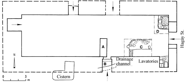
Excavations reached a considerable depth below the white mosaic pavement of a room (no. 554) in the lower story of the Crusader building—a room abutting the so-called Herodian room to the south. Remains of earlier constructions belonging to several periods were uncovered. The earliest consist of small segments of floors from the end of the First Temple period (the eighth to early sixth centuries BCE), to which a wall consisting of several masonry courses laid as headers should perhaps also be attributed. The lower portion of a built and plastered mikveh with a wide flight of stairs descending from west to east was uncovered. The mikveh is assigned to the Hasmonean period (the early to mid-first century BCE); it was blocked with earth fills during the Herodian period, which raised the ground surface in this area by approximately 4 m.
A deep, plastered drainage channel was constructed in this area during the Herodian period (end of the first century BCE). The channel extends along the northern, eastern, and southern walls of the Crusader room. It is a branch of the drainage system constructed in the Tyropoeon Valley, passing beneath the street constructed in Herod’s time along the western wall of the Temple Mount, and conveying water eastward.
A public latrine from the Late Roman period (second–third centuries
12. THE STREET OF THE CHAIN
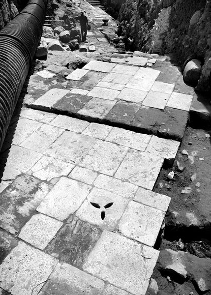
In the early 1990s, a number of limited excavations were conducted by the Israel Antiquities Authority along the eastern side of the Street of the Chain (ha-Shalshelet St.) and in the plaza that separates the street from the Gate of the Chain, in the western wall of the Temple Mount. At a depth of approximately 1–2 m beneath the present surface of the Street of the Chain were found remains of the pavement of an early west–east street leading toward the Temple Mount. It consisted of large carefully laid square stones, 0.3–0.4 m thick, the largest measuring 2 by 1 m.
The westernmost portion of this pavement was excavated by R. Abu Riya at the junction of the Street of the Chain and the staircase descending to el-Wad Street. Two of the pavers bore a row of widthwise grooves. Found in the bedding of the pavement were a few sherds dating to the Late Roman period, apparently the second century CE. On the southern side of this exposed segment of the pavement is a water channel in which Late Roman period pottery was also found.
An additional segment of the pavement was revealed by L. Gershuny in an area abutting the eastern edge of Abu Riya’s excavation area. Beneath this segment was found the apex of one vault in the line of vaults extending westward from Wilson’s Arch. The pottery found beneath the pavement in this spot dates to the first century CE. The vault and the pavement above it thus appear to date to the Second Temple period.
E. Kogan-Zehavi revealed another segment of the pavement at the easternmost end of the Street of the Chain, at the entrance to the plaza in front of the Gate of the Chain. Beneath the pavement were found the tops of vaults. Kogan-Zehavi dates this segment to the Roman period; repairs to its southern part were dated to the Byzantine–Early Islamic period.
In L. Gershuny’s excavations in the plaza in front of the Gate of the Chain was found a stone surface that covers the top of Wilson’s Arch, which abuts the western wall of the Temple Mount. A 10.5-by-6-m segment of a staircase that ascends from west to east was uncovered in E. Kogan-Zehavi’s excavation at the western edge of the plaza in front of the Gate of the Chain. The construction consists of stones of various sizes and is constructed upon Wilson’s Arch. In the southern portion of the paved segment is the square foundation of a now missing column. A staircase ascending from west to east is located in this spot. It consists of two narrow steps (0.4 m wide) and one broad step (2.0 m wide), all 0.2 m high. The style of construction is similar to that of the Herodian period staircase at the entrance to the Huldah Gates. It is clearly part of an ancient staircase that rose from the eastern edge of the ancient Street of the Chain to the gate leading onto the Temple Mount. The excavator dates it to the Herodian period.
During the Early Islamic period, the staircase was narrowed on its northern side by the construction of a long curbstone and on its southern side by a long wall that served as a curbstone. The wall was built along the line of the column base of the previous period. South of the square column base was found the top of a vault constructed during the Umayyad period, north of Wilson’s Arch.
13. OHEL YIẒḤAQ
Excavations by the Israel Antiquities Authority in the Ohel
A segment of pavement of the Secondary Cardo dating to the Byzantine period was uncovered. The flagstones were laid diagonal to the axis of the street, which runs from north to south along the Tyropoeon Valley. Some of the paving stones with carved grooves were laid in other directions, indicating a repair. Additional segments of this street have been found to the north, along the line of present-day el-Wad Street, and to the south, west of the Dung Gate (see above). At the end of the Byzantine period or beginning of the Early Islamic period a building was erected flanking the street from the east; its entrance from the street was blocked in a later phase. At some point in the Early Islamic period a wall was constructed upon the pavement of the street, narrowing it. In the Crusader period, part of a room and a pool uncovered on the eastern side of the street were built. The room opened onto the street, and was apparently a shop or workshop; at some later stage, no later than the fourteenth century CE, the entrance to the room was blocked. South of this structure were found remains of another room with a stone floor and a blocked opening.
A bathhouse from the Mameluke period was found covering the entire excavation area. The building was preserved almost in its entirety, including its western façade, with its entrance flanked by stone benches. The bathhouse included a changing room, an octagonal hot room, small rooms to the west and east of the hot room, warm dry rooms at the center of the building, and an additional room on the eastern side of the building, with a dome decorated in molded plaster. The bathhouse heating system consisted of channels and pipes. This network was connected to a furnace room shared by an adjacent Mameluke period bathhouse referred to as Hammam el-‘Ain.
14. THE SOUTHEASTERN SLOPE OF MOUNT ZION
During 2005–2006, an excavation was conducted on behalf of the Israel Antiquities Authority by Z. Greenhut just above the meeting point of the Central and Kidron Valleys, a short distance to the west of the Pool of Siloam. The excavation area is bordered by a terraced quarried cliff that rises 13 m above its surroundings, with remains of a series of rock-hewn rooms arranged in three stories to the full height of the cliff. Little remains of the outer, stone-built walls of the rooms, but the plan of the structure of which they are apart can be reconstructed. Leveled rock surfaces served as the floors of the various rooms in this structure. The remains were found covered with earth dumps containing mixed pottery sherds dated to the end of the First Temple (eighth to early sixth centuries BCE), Second Temple (first centuries BCE and
Only stepped floors remain of the upper story of the structure. At least three rooms belong to the middle story. The rock cliff served as their western side and provides evidence that the rooms were vaulted or roofed with wooden beams. From the lower story, two rooms were entirely exposed and another two only partially. A dressed, framed opening located in the northern room leads to a natural cavity, apparently a storage area. There was evidence in another room of a white stucco paneled decoration. On the western side of the room, a niche that served as a cupboard was cut with an arched ceiling and covered with white plaster. At the sides of the niche are evenly spaced grooves that supported wooden shelves. Another room leads via a narrow, rock-cut, L-shaped staircase to the basement. In the northeastern corner of the structure were a plastered ritual bath (mikveh) next to a plastered reservoir (otzar).
The remains exposed attest to the existence of a terraced architectural complex that was erected during the Second Temple period (first centuries BCE–CE) at the bottom of the southeastern slope of the southwestern hill, opposite the Pool of Siloam. It illustrates the intensive settlement and high standard of housing in this part of Jerusalem at the end of the Second Temple period.
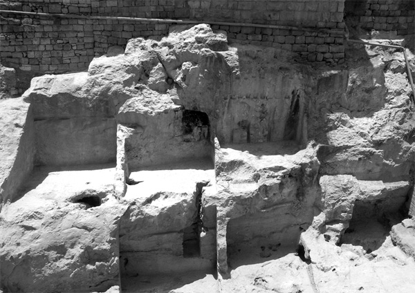
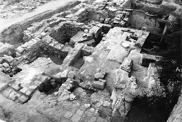
15. THE CHURCH OF ST. PETER IN GALLICANTU
The excavations in the Church of St. Peter in Gallicantu, on the eastern slope of Mount Zion, were conducted from 1992 to 2000. The excavations were carried out by the Instituto Español Bíblico y Arqueológico under the direction of F. Díez, and in some of the excavation seasons, jointly with I. Prieto and J. Campos. Areas B, E, F, and G were excavated in the vicinity of the church. Remains dating from the end of the Hellenistic period to the Early Islamic period were encountered. In general, the remains were found in an extremely poor state of preservation due to extensive robbery of building stones, beginning mainly at the end of the Early Islamic period.
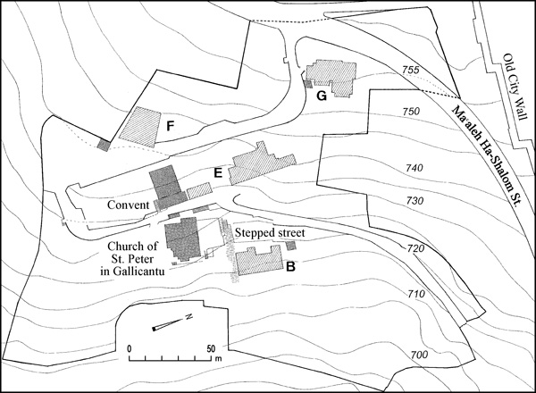
A mikveh and five rock-cut cisterns from the Second Temple period were found in area B; two of the cisterns were reused in the Byzantine period. Part of a stone-paved Byzantine street with a rock-cut channel under its paving stones was also excavated in this area. It extends from north to south, toward the stepped street uncovered by J. Germer-Durand, which ascends from the City of David to Mount Zion.
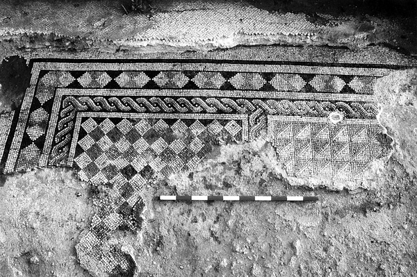
Exposed in area E were a cistern, pool, and the remains of a building with thick walls, all dated to the Second Temple period. Byzantine period remains in the area include two rooms of a building, one paved in a geometric mosaic consisting of squares and hexagons, the other in white mosaic. There is also a very well-constructed Byzantine channel, descending from north to south, preserved only in the northern end of the excavated area. A short section of an Islamic, probably Mameluke, pipe aqueduct was uncovered; it was constructed within the low-level aqueduct of the Second Temple period. Because area E was very disturbed, the remains of two fragments of walls, 1.80 and 2.00 m thick, respectively, could not be dated. One is oriented east–west and should probably be attributed to the pre-Herodian period. The other is oriented southwest–northeast. These walls display different types of construction and do not belong to the same structure.
First Temple period (eighth–early sixth-century BCE) remains of a wall were uncovered in area F. Byzantine period remains include portions of walls and a mosaic floor with multicolored geometric designs. A unique find is a pottery jug containing a hoard of Byzantine gold coins of the sixth–seventh centuries CE. Also apparently dated to this period are the remains of another building, including portions of walls, white mosaic floors, a pavement of stone slabs, and probably a courtyard or square in which the capstone of a cistern was found in situ. In one of the rooms of this structure were found small pools and channels, apparently suggestive of an industrial installation.
Uncovered in area G were the remains of a mansion of the first century CE. It includes an inner courtyard surrounded by rooms with plastered floors and painted, stuccoed walls. Retrieved from inside the building were collapsed stones and various Second Temple period artifacts that attest to its destruction in 70 CE. On the eastern side of this excavation area, portions of additional Second Temple period buildings were uncovered, including the remains of Late Hellenistic period walls constructed on bedrock and a large rectangular cistern with internal pillars that had supported a now-collapsed vault. The cistern was filled with debris including abundant sherds dating to the end of the Second Temple period. A Byzantine period structure that remained in use through the Early Islamic period was also uncovered. Three of its rooms had mosaic pavements, those of the two smaller rooms bearing colored geometric decorations and small crosses. In the larger room, the mosaic was replaced in a later phase by paving stones.
16. THE ḤURVAH SYNAGOGUE COMPOUND
Excavations in the
The earliest remains were portions of walls and gravelly earth fills of the Iron Age II (eighth–early sixth centuries BCE) uncovered on the northeastern side of the excavation area. At the center of the area was a square installation (1.2 by 1.2 m, 1 m deep) cut into bedrock.
Fragmentary remains of two construction phases dated to the late Second Temple period were found in the center of the excavation area. To the early phase, which is dated to the first century BCE, belongs a small, stepped, quarried mikveh. Part of the ceiling of the mikveh is cut into bedrock. It was intentionally blocked with earth and stones during the later phase, in the first century CE, when a building was constructed over it. Parts of two rooms and two mikvehs of the building were exposed. A rock-cut threshold of a doorway separates the two rooms. The eastern part of the earth floor of the western room lay upon a quarried bedrock surface, its western part over the blocked mikveh of the early building phase. The earth floor of the eastern room was laid upon an earth fill over shallow quarrying in the bedrock. Upon the floors of these rooms were fallen squared building stones and accumulations of earth, burnt beams, and sherds of partially restorable vessels. The remains of two poorly preserved mikvehs were discovered south and west of the rooms, but separated from them by later construction. All of these remains are part of a Herodian period residential structure dated to the first century CE. The finds indicate the destruction of the building by fire during the Roman conquest of Jerusalem in 70 CE, much like the evidence from the more impressive conflagration remains left in the Burnt House, also uncovered in the Jewish Quarter.
Remains of two segments of a stone pavement of the Byzantine period, totaling 10 m long and 3.7 m wide, were found on the southwestern part of the excavation area. The pavement is part of a sixth-century CE paved street that ascended from the Cardo eastward, toward the area today located at the center of the Jewish Quarter. It is identical in its details to that of the Cardo, which passes several meters west of the excavation area. The pavement rests directly upon a rock-cut surface between two quarried walls, which remain standing up to 1 m in places. It slopes slightly upward from west to east and consists of rows of large slabs of hard limestone, carefully trimmed and fitted, but very worn and cracked from extensive use. Along the northern side of the pavement is a massive wall (1.5 m wide) constructed on the quarried rock wall; it was built of roughly trimmed stones preserved in several places to six to eight courses. At the center of the exposed wall was a gap, evidence of an opening onto the street. Only a small portion of the wall on the opposite side of the street remained.
Part of a room from the Early Islamic period was found at the eastern edge of the excavation area. The western wall of the room is both quarried in bedrock and built of stone. The room has a simple white mosaic floor, the southern part of which was laid upon a quarried rock surface; the northern portion, where the bedrock is lower, was laid upon an earth fill. Portions of two jars dated to the eighth–ninth century CE were found buried upside-down beneath the floor in this part of the room.
During the Mameluke period, the paved Byzantine street went out of use and deposits of earth and stones reaching a depth of 2 m accumulated upon it. The eastern edge of the revealed segment of the street was destroyed during this period with the construction of a vaulted cistern. A square installation was uncovered north of the wall that bounded the street to the north. Quarried into the bedrock to a depth of 1 m, the installation was accessed by a narrow staircase leading down into it. Numerous finds dated to the twelfth–thirteenth centuries were retrieved from the earth fills upon the street and in the installation.
17. THE KISHLEH BUILDING
In 2000–2001, excavations were conducted by A. Re’em, on behalf of the Israel Antiquities Authority, within the Kishleh building, which is located just to the south of the Jerusalem Citadel. A sequence of archaeological remains from the Iron Age II to the Ayyubid period was uncovered in the foundations of the building.
Remains of walls and floors dated to the eighth to early sixth centuries BCE were found. The principal of these is a buttressed north–south wall, 15 m of which was uncovered. The wall is constructed of large, partially trimmed stones and was preserved to a height of 2.5–3.0 m; its width was not established. The nature of the wall’s construction, dimensions, and location at the western edge of the southwestern hill of ancient Jerusalem suggest that it is another part of the city wall that surrounded the hill during the First Temple period, remains of which have been found to the north in the Citadel and to the south in the Armenian Garden and on Mount Zion.
A 5-m-wide wall was found at the western edge of the excavation area. Its inner face is constructed of well-dressed stones with margins and a pronounced rough boss. Its outer face lies beneath the Ottoman Old City wall. It is another part of the First Wall of the Hasmonean period, portions of which have been exposed to the north in the Citadel and to the south along the western side of the southwestern hill.
Two parallel walls running north–south along the entire length of the excavation area were uncovered, part of the platform on which Herod’s palace was constructed. The western wall is 1.8 m wide, preserved to a height of 4 m; the eastern is 3 m wide, preserved to a height of 7 m. The walls rest upon bedrock and are constructed of a combination of stones of various types, including ones in secondary use. The space between the walls is filled with leveled, compressed layers of earth. Abutting the eastern wall is a drainage channel covered with stone slabs that extends below the fortification line and to its west. Similar remains were encountered to the north, in the Citadel, and to the south, in the area of the Armenian Garden.
Portions of a twelfth–thirteenth-century CE wall incorporated into the Old City wall, and eight industrial pools of varying sizes and depths were also uncovered.
HILLEL GEVA
18. THE MAMILLAH AREA
The Mamillah area is located along the western side of the Old City wall, outside Jaffa Gate. It was first explored in 1887 by C. Schick, who reported the discovery of a solid wall running parallel to the Old City wall. In 1927 and 1935, the Mandatory Department of Antiquities excavated several Iron Age II tombs, later published by R. Amiran. In 1984, H. Goldfus exposed a small segment of C. Schick’s wall close to Jaffa Gate. Excavations were also conducted to the north of Jaffa Gate by A. Maeir (1989). The large-scale excavations in the Mamillah area were conducted by R. Reich and E. Shukron on behalf of the Israel Antiquities Authority in 1989–1995.
IRON AGE II TOMBS. The earliest remains in this area belong to a late Iron Age II (eighth to early sixth century BCE) cemetery. Most tombs were damaged by later Late Roman and Byzantine quarrying operations. Roughly ten were found to contain burial goods; some of these tombs were preserved in their entirety. The cemetery is clearly associated with the quarter newly founded in the eighth century BCE on the southwestern hill of the city.
Several of the tombs (nos. 5
Two of the late Iron Age tombs were reused in the period following the destruction of Iron Age Jerusalem. An assemblage of pottery vessels of the sixth century BCE, similar to that found in the tomb at Ketef Hinnom, was found in tomb 5. An assemblage of mid-fifth century BCE artifacts, including some cosmetic implements and an imported black Attic amphoriskos, was found in tomb 19. These finds show that a relatively small community remained in Jerusalem or in close proximity to it after the destruction and exile of 586 BCE.
HELLENISTIC PERIOD TOMBS. Several tombs of a type new to Jerusalem were excavated. The entrance to the tombs is via a vertical, rectangular shaft. At the bottom of the shafts are rock-cut loculi (kokhim). Such shaft tombs have one, two, or four loculi. A few artifacts are indicative of the second century BCE. This type of tomb appears to mark the first appearance of the loculi, which would become so common in Jerusalem burial caves of the first centuries BCE and CE.
LATE ROMAN DEBRIS. The area was covered with quarries from which medium-sized blocks of stone were extracted. These are difficult to date, but, since they cut through the Iron Age tombs, they clearly postdate the Iron Age. In addition, a large amount of debris covering the area contained broken roof tiles and bricks bearing the impressed insignia of the Tenth Roman Legion, which was garrisoned in the city.
A BYZANTINE PERIOD EXTRA-MURAL QUARTER. The most intensive activity in this area took place during the Byzantine and Early Islamic periods. It is assumed to have been extra-mural in those periods, as small segments of the contemporaneous city wall have been uncovered in the Citadel. The location of the Byzantine western city gate of Jerusalem can be inferred from the discovery of an extra-mural street leading to it in the excavation area, c. 20 m south of Jaffa Gate. This street was flanked on both sides by elongated blocks of buildings constructed on terraces descending outward from the center of the city. The buildings were divided into uniform units containing a variety of installations; they may have been shops. The buildings on the northern side of the street, facing south, had a roofed gallery shading the sidewalk; those on the southern side of the street would have enjoyed natural shade.
The excavations by A. Maeir exposed another street leading northwest from Jaffa Gate, with an elongated building flanking it to the east. The rooms of the building were used as shops. The small finds they yielded suggest that pilgrims purchased merchandise in them. These finds include a marble slab with an Armenian inscription, a miniature pottery flask originating in Asia Minor, and a small cruciform bronze pendant with a wood inlay. Further to the west was another elongated building which might have served as lodging for pilgrims. Mosaic floors there bore Greek versions of Psalms 95:6 and 118:6–7.
The ruins of a bathhouse are located directly below the Ottoman Jaffa Gate and the Ayyubid city wall. The location of this establishment in the public area near the gate, the street, and the shops was carefully chosen. It is also situated near and slightly lower than the adjacent aqueduct that entered the city nearby. The aqueduct likely supplied water to the bathhouse.
The remains of this aqueduct, constructed to carry water from Birkat Mamillah (700 m west of Jaffa Gate) to Birkat Hammam el-Batraq (the so-called Hezekiah’s Pool, within the Old City near Jaffa Gate) was partially exposed along Mamillah Street by A. Maeir, R. Reich, and E. Shukron, and later by Y. Billig and E. Assaf. The aqueduct is a 0.7-m-deep and 0.4-m-wide channel resting on a low wall. It entered the city roughly 50 m northwest of Jaffa Gate. Open areas were left on either side of it. It was in use from the Byzantine period to the end of the nineteenth century. No conclusive evidence for a Roman aqueduct has yet been found in this area.
A BYZANTINE PERIOD CRYPT. A cemetery situated roughly 100 m west of Jaffa Gate contained simple inhumations, distinct from the many built or rock-cut tombs of this period encountered around the city, particularly on its eastern side. Exceptional is tomb 10, a natural burial cave from the Byzantine period that contained an extremely large quantity of human bones piled in apparent disarray. A simple chapel stood in front of it. The tiny apse is adorned with a wall painting representing the Annunciation, only the angel of which has survived. The mosaic floor bears a Greek inscription in tabula ansata: “for the salvation and succor of those whose names only the Lord knows.” The few artifacts found among the bones were several cross-pendants of stone and bronze, indicating that the interred individuals were Christian. The latest of the c. 130 coins found in the crypt is a gold coin minted under Phocas (602–610
AN AYYUBID FORTIFICATION. The latest architectural feature discovered in this area is a fortification line located parallel to the Old City wall, roughly 6.25 m to its west. Approximately 110 m of the wall has been exposed, extending northwest of the Jaffa Gate. Part of this segment survives as masonry courses, while farther to the north only the lower, rock-cut foundation has survived. The width of this wall could be established in only one spot, where it measures c. 3.20 m. Next to Jaffa Gate the wall was largely constructed upon the remains of the Byzantine period bathhouse. At the northwestern edge of the excavated segment of the wall, the slightly inclined, rock-hewn base of a protruding tower, up to 3.3 m high, was exposed. At the point where the wall and tower meet, a rock-cut staircase descends from the tower to the rock surface just outside of it. The staircase probably led to a small postern, which has not survived.
The builders of the wall appear to have reused stones from various sources in its construction. The large stone collapse found along the line of the wall included some dressed stones, stones with mason marks, and stones bearing traces of a polychrome wall painting, probably from a destroyed Crusader church. One piece depicts the head of a young Madonna wearing a head shawl, clearly indicating that the builders of the wall utilized building materials salvaged from a nearby Crusader church in constructing their fortifications.
The stratigraphic positioning of the wall over a Byzantine bathhouse and below the foundations of the Ottoman Jaffa Gate, the thirteenth–fourteenth century pottery found in the earthen layer that covers the stone collapse, the reuse of Crusader masonry in the wall, and a coin of al-Malik al-Kamil Nasir ad-Din al-Ma’ali Muhammad (1211–1237
RONNY REICH
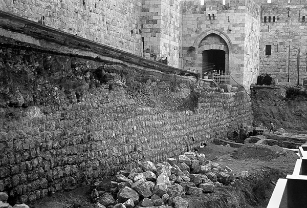
19. THE HEROD’S GATE AREA
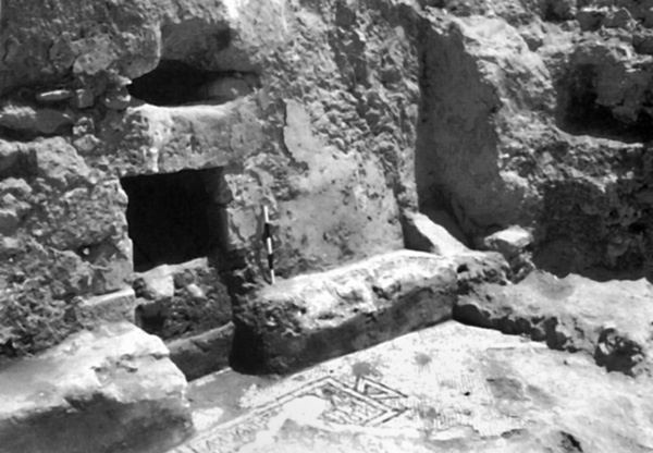
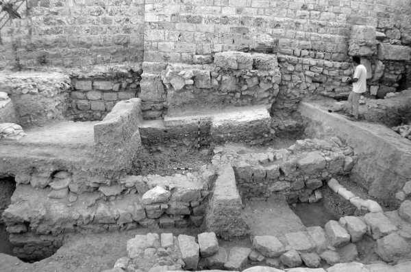
Excavations in the area of Herod’s Gate were conducted in the years 1998, 2001, and 2004–2005 by Y. Baruch, G. Avni, and G. Parnos, on behalf of the Israel Antiquities Authority. The excavated area totals 600 sq m, and is situated adjacent to the northeastern corner of the Old City of Jerusalem and within the city wall, c. 120 m east of Herod’s Gate. Since the beginning of the Ottoman period, this area had been an open field known as Burj el-Laqlaq (the Storks’ Tower), after the northwestern tower of the Old City wall. In photographs and maps of the nineteenth and twentieth centuries, the area within the walls east of Herod’s Gate appears mainly as agricultural plots.
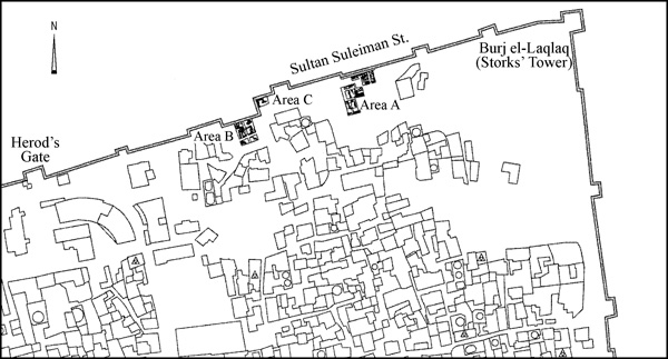
The excavations, which reached bedrock in most places, indicate that the bedrock in this area gently slopes from east to west toward a wadi bed known in the Second Temple period as the Bezetha Valley, which begins west of the Rockefeller Museum and descends to the Kidron Valley north of the Temple Mount. It appears that the wadi filled with debris over the years, a result of building activities. The excavations were conducted in three areas—A, B, and C—all abutting the Old City wall. Several settlement strata were distinguished, dating from the First Temple period (Iron Age II) to the end of the Ottoman period.
FIRST TEMPLE AND HELLENISTIC PERIOD FINDS. The finds from the First Temple period (eighth–sixth centuries BCE) were encountered in area A. They include pottery, such as a jar handle bearing a lamelekh seal impression of the single-wing type. No architectural remains were uncovered. The finds appear to be related to activity outside the walls of Jerusalem at the end of that period, evidenced generally by quarries, rock-cut burial caves, and pottery. Retrieved together with the Iron Age pottery were Hellenistic period finds, including two seal-impressed Rhodian jar handles and a number of Hasmonean period coins. Layers from this period covered an area of ashlar quarries extending northward.
LATE SECOND TEMPLE PERIOD BUILDINGS. Most of the late Second Temple period remains were found in area A. They include stone walls preserved up to 1.50 m in height, apparently related to the expansion of Jerusalem beyond the line of the First and Second Walls and the construction of the “new city” in this vicinity, referred to by Josephus (War V, 142–162). The buildings exposed in area A were built upon stone terraces. On the uppermost terrace was exposed the outer face of a 6-m-long wall segment (wall 1062) belonging to a building erected upon the earlier stone quarries. The wall is constructed of carefully trimmed stones laid as headers and stretchers.
In the western part of area A, upon the lower stone terrace, was exposed a portion of a structure (building 1000) with massive walls (c. 1 m thick) constructed of large stones, roughly trimmed on their outer face. This building appears to extend northward beyond the line of the later walls constructed over it. Within the building were found a thick layer (c. 1.8 m) of pottery sherds and whole vessels. Two trenches excavated within this fill yielded hundreds of sherds of a variety of vessels, primarily cooking pots and thin bowls, dated to the end of the Second Temple period. An inscription in black ink in typical Second Temple period Hebrew script reading smq’ was found on one of the jar sherds, apparently indicating the contents of the container, perhaps a type of red wine. Sherds of stone vessels typical of the period and several coins of the first century CE were also found. Many of the cooking vessel sherds had small holes pierced in their sides. Perforated cooking pots are known from other excavations in Jerusalem, such as at the City of David, near the Temple Mount, and in the Jewish Quarter. One theory for this phenomenon is that the hole disqualified the vessel as a container, thus dissolving it of its ritual impurity if it had been exposed to some defiling element, as written in the Mishnah (Kelim 2, 3). Earth fills and floors containing more sherds of the same period were associated with the walls of this building.
LATE ROMAN PERIOD FINDS. This area of the city appears to have been abandoned following the Roman conquest in 70 CE. In area A, layers with a few sherds dated to the Late Roman period were found upon the walls of building 1000. On the eastern terrace in this area, a typical second–third century CE cooking pot containing remains of ash and animal bones was found inside a pit lined with flat stones, which had severed a Second Temple period wall (wall 1062). Also found in this pit were earth fills containing copious amounts of Roman sherds and roof tiles bearing stamps of the Tenth Roman Legion.
THE “ROMAN–BYZANTINE” CITY WALL. In area B, a segment of the so-called Roman–Byzantine city wall was found directly below the Old City wall. The segment of wall exposed is constructed of square, smoothed ashlars. Some of these are typical Herodian building stones in secondary use. Nine courses of this portion of the wall have been preserved, reaching a height of c. 5 m. The seven lower courses were constructed as receding courses, giving the inner face of the wall a stepped appearance. The earth fills associated with the line of the wall slope southward. They appear to be intentional fills deposited in two different periods: the first at the time of the construction of the wall, as it contained third–fifth century CE pottery; and the second in the second half of the sixth century CE.
Area A was excavated down to the base of the Old City wall, but no remains of the city wall encountered in area B were encountered. Nor is there any indication of the wall from this point up to the northeastern corner of the Old City wall. This probably indicates that the Roman–Byzantine city wall of Jerusalem did not extend to the northeastern corner of the Old City, but turned southward at a sharp angle and extended along the Bezetha Valley before joining up with what is now the eastern line of the Old City wall at some point along the eastern wall of the Temple Mount.
The wall discovered in area B remained in use throughout the Byzantine period. In area A, an earth fill, floors, and segments of poorly constructed walls of an unclear plan were associated with the line of the city wall. Fills containing considerable quantities of white tesserae and tesserae production waste attest to this having been a production site for mosaic tiles.
AN EARLY ISLAMIC PERIOD FORTIFICATION AND QUARTER. The principal Early Islamic period remains were exposed in area A, where a massive wall was revealed directly beneath and along the course of the Old City wall. It is built of roughly shaped stones and is of entirely different construction than the Roman–Byzantine wall found in area B. Additional segments of the wall were exposed in area C. Also exposed in area C were carefully carved, profiled masonry stones—perhaps part of a gate that once stood in this area—among a stone collapse. The pottery found within this collapse, like that of the earth fill associated with segments of the wall found in area A, is dated to the end of the Early Islamic period (tenth–eleventh centuries
Uncovered south of this wall were fragmentary walls of buildings, apparently part of a dense residential quarter showing no evidence of advance planning. The walls are simple constructions of small stones bonded with clay. The floors are of tamped chalk. These remains date from the end of the Byzantine period and remained in use, with modifications, at least until the eleventh century CE.
CRUSADER AND AYYUBID PERIOD FORTIFICATIONS. Based upon detailed historical descriptions of the Crusader conquest, it was in this area of the city that the Crusaders broke through the walls of Jerusalem on July 15, 1099. Actual evidence for the line of the city wall of Jerusalem during the Middle Ages was found in the excavation next to the Old City wall in areas A and C. The abovementioned Early Islamic period wall was buttressed by a fortification preserved as a row of piers. Another wall was found to extend 25 m from the remains of the massive piers southward. Earth fills containing numerous iron arrowheads were associated with the remains of the wall with piers. A survey in the vicinity of the site, carried out during the excavation, revealed another wall, perpendicular to the line of the Old City wall, some 20 m east of area A. Its visible length upon the surface was 11 m, its width 2.8 m, and its preservation height 2 m above the surface. Another wall with similar characteristics and also clearly related to the line of the Old City wall was surveyed at a distance of c. 10 m from area B. Associated with it on the east is a building with a roofing system of pointed arches resting upon ashlar piers. The piers bear diagonal stonecutting marks typical of the Middle Ages. The remains noted appear to constitute part of a single fortification system, the precise nature of which has not yet been established.
MAMELUKE PERIOD BUILDINGS. The findings in area B suggest that the city wall of the Early Islamic and medieval periods was in a poor state by the Mameluke period, perhaps even partly in ruins. Some of its stones were probably utilized to construct the private dwellings built adjacent to and abutting the city wall. Historical sources, such as the description by Mujir ad-Din (1495) and Mameluke period maps, show that much of the walls of Jerusalem were derelict under Mameluke rule. Only upon the reconstruction of the city wall at the beginning of the Ottoman period did this area once again become a fortified part of the city.
Remains of private construction of the Mameluke period were uncovered in the excavation. In area A, a building whose walls rest upon those of Early Islamic and Second Temple period buildings was partly uncovered. It was mostly constructed of stones in secondary use. In its southern wall was a doorway that led to an open area. Two phases were found in its floor; the bottom floor was of coarsely crushed chalk, the upper floor of plaster painted bright red. The building was severed during the Mameluke period by a broad trench and deep pits sunk to bedrock. The trench was filled with deposits containing abundant finds dated to the Mameluke period.
Another building was excavated in area B, next to the line of the Old City wall. Its walls were constructed of stones in secondary use, consisting both of typical Herodian masonry and stones taken from the Roman–Byzantine city wall. An unroofed courtyard was constructed north of the building; at its center was a deep cistern. Beneath the house was a room with a vaulted roof supported by ashlar corner piers, probably the ground floor of the structure, but possibly the remains of an earlier building.
THE OLD CITY WALL AND OTHER REMAINS. The Old City wall was constructed during the reign of Sultan Suleiman the Magnificent in 1535–1538. A broad trench was dug prior to construction, apparently along many portions of the earlier fortification line. As a result, the Mameluke building in area B was destroyed. The fill in the trench included large amounts of stone cutting debris, undoubtedly related to the construction of the wall itself. South of the wall were exposed the remains of Mameluke and perhaps earlier buildings, which were used during the Ottoman period. Among the numerous artifacts found in these buildings were coffee cups and clay pipes.
YUVAL BARUCH, GIDEON AVNI, GIORA PARNOS
20. THE CHURCH OF THE HOLY SEPULCHER
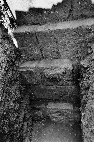
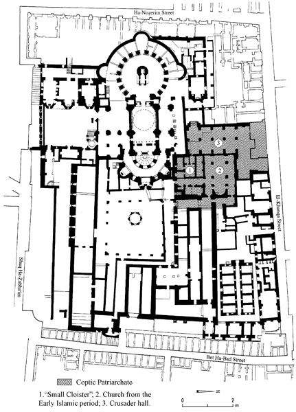
An excavation was conducted in 1997 by G. Avni and J. Seligman, on behalf of the Israel Antiquities Authority, within the confines of the Coptic Patriarchate in the Church of the Holy Sepulcher. Three structures incorporated into a Crusader (twelfth-century) monastery were revealed. One was already known from previous probes in the church as the Small Cloister—a small courtyard surrounded by a colonnade, as was customary in Europe in the Middle Ages. Its architectural character suggests that it was part of the monastery complex, perhaps used by Augustine monks who served at the church. Another structure excavated is a large hall (c. 31 by 13 m), datable by its building style to the Crusader period. It includes ten bays, and was described in previous surveys as a hospital within the monastery complex. Some of the bays were used as garbage pits for the shops along the adjacent
21. THE NORTHWESTERN CORNER OF THE OLD CITY
In 1999–2000, segments of fortification remains of various periods were found in the northwestern corner of the Old City during excavations under the direction of S. Weksler-Bdolah, on behalf of the Israel Antiquities Authority. The remains can be quite well associated with the fortifications uncovered in the area in the nineteenth and twentieth centuries both inside and outside the Old City walls. The excavations were conducted in a small area (8.00 by 3.00 m), but are nevertheless instructive on the city’s fortification sequence over its various periods.
The earliest stratum revealed dates from the Byzantine period; only a floor with a drainage conduit survives from it. Other structures of this period located here were severed by the Ayyubid tower (see below), so that it is impossible to ascertain the nature of the Byzantine buildings in this spot. In light of the finds from the adjacent Knight’s Palace Hotel, it can be established that this area of the Old City was also enclosed within the so-called Roman–Byzantine city wall, which did not, as it has been suggested, follow a course farther to the east. The stratum above the Byzantine remains can be chronologically associated with the lowest course of the city wall (from the ninth century CE and slightly later), which was revealed under the Old City wall in this area. Subsequently, the entire area was covered in earth fills, leading to the conclusion that it was not resettled until the Crusader period. (It is recalled that found nearby was a massive tower, datable to the Fatimid period, perhaps the Tancred Tower mentioned in documents from the Crusader period.)
The next stratum consists of an Ayyubid tower (twelfth or beginning of thirteenth century
Additional remains adjoining the tower—including a stone bench along its eastern side and another structure built perpendicular to the city wall and utilizing the tower as one of its walls—represent a later phase within the same period. After these structures were destroyed, the area was covered in earth fills, which abut the upper portion of the Ayyubid tower. It seems that the stratum consisting of these fills can be associated with the Mameluke period, during which no more fortifications were added in this area. This conclusion finds support in the ceramic finds unearthed during the excavation. The uppermost stratum uncovered is the Ottoman wall, which was built directly on the tower and adjoining wall.
22. THE KNIGHT’S PALACE HOTEL
In 1996, excavations were conducted by J. Seligman on behalf of the Israel Antiquities Authority in a few small areas alongside the modern Knight’s Palace Hotel, located in the northwestern corner of the Old City and adjacent to the Old City wall. This area was settled in the Byzantine period, but aside from ceramic finds, nothing remains of this occupational phase. The bulk of the findings date to the Middle Ages. Under the modern building was revealed a broad wall, constructed of large stones exhibiting a drafting typical of the twelfth and thirteenth centuries. The wall is probably the thirteenth-century city wall, the course of which in this area differs from that of the Old City wall, as had been already ascertained during excavations to the north in
DAN BAHAT
THE NECROPOLIS OF THE SECOND TEMPLE PERIOD
Over 35 rock-cut tombs have been exposed over the past decade in archaeological excavations of the necropolis of Jerusalem. In most cases, these discoveries were the result of land development projects or clandestine looting activities. Some of the major findings are described below.
TOMBS ON THE WESTERN SLOPES OF MOUNT SCOPUS
In 1991, S. Weksler-Bdolah of the Israel Antiquities Authority excavated four adjacent burial caves (A–D) and rock-cut installations on the western slopes of Mount Scopus.
CAVE A. Cave A has an unusual plan, consisting of a large burial hall with a high, slightly arched ceiling. A standing pit was hewn in the center of the hall. A plaster-covered U-shaped “table” or ledge encircled approximately half the circumference of the cave. This ledge, raised c. 70 cm from the floor and located c. 40 cm from the walls of the hall, is unparalleled in the architecture of Jerusalem tombs. The floor and walls of the hall were plastered, and probably also painted. The northern wall, partially reinforced with building stones, has two loculi (kokhim). Nine loculi, a small arcosolium, and a collection niche were cut in the three other walls of the hall. In a later phase, alterations were made in the plan of the hall. The ledge was extended to meet the four walls of the hall, and its surface was widened; these additions were not plastered. The two loculus openings in the northern wall were sealed.
A total of nine ossuaries were found, some of them ornate. The name Yehosef son of Yehonatan was inscribed in Hebrew on one ossuary, the name Elisha inscribed in Paleo-Hebrew on another. Skeletal remains, pottery vessels, a small piriform glass bottle, and fragments of a stone bowl were recovered.
CAVE B. The entrance to cave B was hewn into the wall of a plastered, bell-shaped water cistern after it had gone out of use. It descends into the central burial chamber, from which two smaller chambers were accessed. In the center of each chamber is a standing pit surrounded by ledges. The quarrying of cave B cut into the two northern loculi of cave A, the original openings of which were then sealed. Four decorated ossuaries were discovered in the cave; two bore names in Greek. Skeletal remains and fragmentary pottery were also recovered.
CAVE C. The entrance to cave C was cut in the western wall of a defunct mikveh. It was found sealed with a large stone, which had been buttressed by another stone placed outside of it. The opening descends into the burial chamber, in the center of which a standing pit surrounded by ledges was quarried. Three loculi were cut into the northern wall of the chamber. A passage in the western wall leads to an interior chamber, which was used as an ossuary repository. Eleven ossuaries were found in the cave, some bearing ornament, along with skeletal remains of 58 individuals and an assemblage of pottery vessels, lamps, and glass bottles.
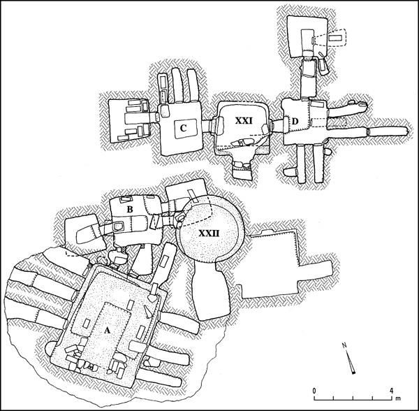
CAVE D. The mikveh from which cave C was accessed was also the entrance point for cave D. That cave’s opening had been cut into the eastern wall of the mikveh; it also was found sealed with a large stone. In its first burial chamber is a standing pit surrounded by ledges. Four loculi were cut into two of the walls; there were collection niches in three of the walls of these loculi. A lower loculus was hewn in the eastern wall of the standing pit. A loculus in the northern wall of the chamber had been converted into a passage to an additional chamber, in the center of which was a standing pit surrounded by ledges. A lower loculus located in the wall of the standing pit contained a decorated ossuary bearing the name Shalom written in charcoal in Hebrew letters. Three ossuaries, pottery vessels, and the skeletal remains of 10 individuals were found in the cave.
SUMMARY. The cluster of burial caves on the western slopes of Mount Scopus reflects two periods of use. In the earlier period, which is dated to the first century BCE, the water cistern, mikveh, and cave A were hewn into the bedrock and plastered. In the later period, dated to the first century CE to the destruction of 70 CE, the water cistern and mikveh went out of use and were converted into vestibules for burial caves. Cave A also underwent changes. During this later period, burial in the caves was according to the prevailing custom of primary burial followed by the ossilegium.
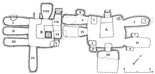
TOMBS IN THE REḤAVIA NEIGHBORHOOD
Two adjacent rock-cut burial caves were uncovered on Gaza Street in the
The entrance to the southern cave (B) is on its western side. It descends to the burial chamber with its irregular standing pit surrounded by ledges. Four loculi were hewn in two of the walls, one of which had a collection pit quarried in the floor. The two lower loculi, one of them squat and wide, were hewn in the lower part of the northern wall, beneath an arcosolium. A collection niche was hewn in a corner of the northern wall; a short loculus was cut in the western wall of the standing pit. Two ossuaries were found in the cave. The finds include wheel-made, knife-pared lamps and fragments of ceramic vessels indicating that the cave was in use in the first centuries BCE and CE.
TOMBS IN THE AREA OF AKELDAMA, LOWER HINNOM VALLEY
The burial complex in the area of Akeldama was opened and plundered by antiquities looters in 1998. It was subsequently documented by B. Zissu, S. Gibson, and J. Tabor in 1998 and again in 2000, following further looting. The complex contains two burial chambers hewn at different levels. The upper burial chamber (A) has nine loculi and two collection niches cut into its walls. A broad loculus in the northern wall of chamber A, east of the entrance, was converted into a passageway to the lower burial chamber (B). Six loculi and a small square room were carved in the walls of this chamber.
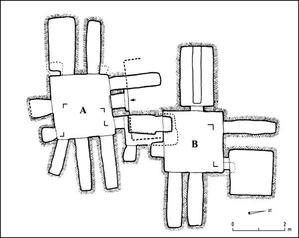
The loculus near the northwestern corner of chamber B is set high in the wall of the cave, close to the ceiling, as the tomb cutters attempted to avoid a broad natural fissure in the bedrock by positioning the loculus above it. This unusual location, together with the sealing of the loculus with a close-fitting stone slab and mortar, created a protected environment that facilitated preservation of organic material. The loculus contained a few skeletal remains and hair belonging to a male individual. DNA tests carried out by C. Greenblatt indicate that the individual suffered from leprosy but died of acute tuberculosis. Also preserved were large pieces of cloth, probably remains of a shroud. Examination by K. Vernon and O. Shamir revealed two types of fabric, not interwoven: a high-quality wool of simple weave and a fabric of vegetal origin, presumably linen. Radiocarbon tests of these remains, conducted by D. Donohue, have provided a date in the first half of the first century CE. In addition, fragments of some 25 ossuaries, some of them ornate, were recovered from the cave, including a large decorated ossuary of hard limestone. The names Maria, Shimon son of Shulai, and Phineas were inscribed in Hebrew and Greek letters on three of the ossuaries.
A burial complex was discovered in March 2005 during illegal excavation activity on the slopes of the Kidron Valley, above the area where it merges with the Hinnom Valley. This complex was documented by Y. Baruch, A. Ganor, and B. Zissu on behalf of the Israel Antiquities Authority in March 2005. The entrance into the burial complex was hewn into the western wall of a low cliff; it was closed with a hinged stone door that opened inward, as attested by the socket hewn in the lintel. The opening descends into burial room 1, with its eight loculi and one collection pit cut into three of its walls. In the center of its western wall is an arched opening leading into room 2, which includes two arcosolia with flat bottoms and ten loculi; the arcosolia were hewn into the upper half of the walls, the loculi underneath. A loculus located in the center of the northern wall of the room was left unfinished, presumably when the quarrymen became aware of a natural fissure in the bedrock. The fissure was carefully sealed with mortar and covered with white and gray plaster. The southern loculus in the eastern wall was widened, and a stepped passage was hewn in the floor, which descends to lower room 3. Two arcosolia and a square niche were quarried in its walls, one in each wall. Each arcosolium contained a burial trough, which was most probably closed with horizontal stone slabs, laid on the meticulously hewn grooves. Each of the burial troughs had a rounded headrest at its eastern end. A vertical shaft was cut in the floor of the southern loculus of the western wall of room 2, converting it into a passage to room 4; an arched, short passage cut at the bottom of the shaft leads to the room. Three of the walls in room 4 were fitted with an arcosolium, hewn into the bottoms of which were burial troughs with rounded headrests.
The cave contained human bones and few finds, due to extensive looting. Ossuary fragments and a few pottery sherds indicate that the original use of the cave was during the first century CE. Some fragments of glass candlestick-type bottles point to a secondary use during the Late Roman period.
Each of the troughs was apparently sealed with horizontal stone slabs, which were laid on grooves, carefully hewn around the long edges of each trough, and sealed with mortar. Unfortunately none of the slabs were found, but their existence is suggested by the Hebrew letters aleph to waw, marked in charcoal or incised in the plaster on the wall. The letters were probably meant to indicate the order of placement of the cover slabs. Interestingly, similar letters, aleph to zayin, were marked on stone slabs which covered a burial trough in an arcosolium in chamber D of Akeldama cave I, documented in 1989 by G. Avni and Z. Greenhut.
TOMBS IN THE ARNONA NEIGHBORHOOD
Two burial caves were exposed in the Arnona neighborhood in the southern area of the modern city. One was discovered in 1992 during work on Beth Ha‘aravah Street; it was examined by Z. Greenhut and G. Solimany on behalf of the Israel Antiquities Authority. A standing pit surrounded by ledges was hewn in the center of its burial chamber, and nine loculi were cut in three of the walls of the chamber, three in each wall. Two ossuaries, skeletal remains, and a candlestick-type glass bottle were found in the cave. The finds indicate that the cave was used during the first and second centuries CE, apparently up to the Second Jewish Revolt. This cave joins a group of some 20 known caves in the city’s vicinity that contain finds from the period between the First and Second Jewish Revolts.
In 1993, Y. Billig excavated a burial cave located near the abovementioned cave. It consists of a burial chamber with a standing pit surrounded by ledges. Six loculi were cut into three of its walls, two in each wall; each loculus was found sealed with a slab. A short loculus and a collection niche were cut in the southwestern corner of the chamber. Ten ossuaries and the lid of an additional ossuary were found in the cave. Three of the ossuaries were decorated; three others were inscribed, one with a warning against the reuse of the ossuary by comparing it to a sacrifice (korban)—forbidden due to its holiness. The warning was written twice, once in Aramaic and once in Hebrew. The pottery assemblage and a prutah from 17 CE attest to the continuous use of the burial cave from the end of the second century BCE to the first century CE.
THE TOMBS OF BENE ḤEZIR AND ZECHARIAH
The well-known burial complex of the Tombs of Bene
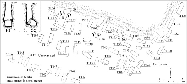
Avigad originally reconstructed the nefesh, which is mentioned in the Bene
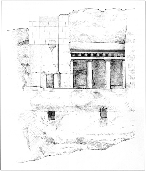
THE CAVE OF THE LITTLE SANHEDRIN
The burial complex popularly known as the Cave of the Little Sanhedrin is located c. 50 m west of the Cave of Simon the Just, in the northern cliff of the upper Kidron Valley. The complex, which underwent later alterations, had never been thoroughly explored. At some point, probably in 1902, the site was cleared of accumulated soil. B. Zissu and A. Kloner undertook a detailed survey of the cave in 1998.
The complex consists of two branches sharing a common vestibule and fronted by a courtyard. Each branch consists of a central chamber flanked by three side chambers, accessed via high openings. The complex has a total of 9 chambers, 19 arcosolia, and 9 loculi. The location of the loculi and their relation to the arcosolia imply that they were a latter addition to the complex. On the basis of the architecture of the complex, and the similarity of its features to burial caves in the Sanhedria neighborhood, it is possible to date the initial use of the cave to the first century CE.
THE SHAFT-TOMB CEMETERY AT BEIT ṢAFAFA
Fifty shaft tombs were revealed in 1996 during the construction of a new road on a broad terrace on the southern slope of
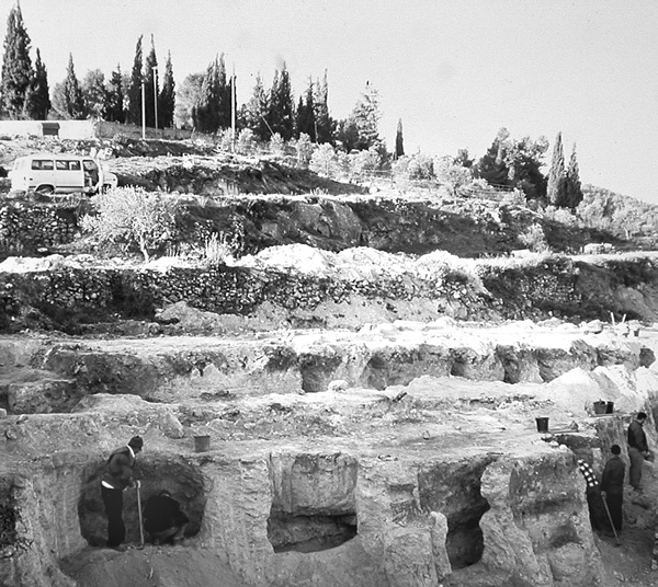
A defunct water reservoir was detected approximately 30 m east of the cemetery. The original opening in its ceiling had been sealed with a large stone slab. Considerable amounts of pottery sherds dating from the first centuries BCE and CE, together with fragmentary skeletal remains, were deposited on the floor of the reservoir.
Shaft burials from the Second Temple period are rare in Jerusalem. The cemetery at Beit
AMOS KLONER, BOAZ ZISSU
EXCAVATIONS IN THE VICINITY OF THE ANCIENT CITY
STONE-VESSEL PRODUCTION CAVES ON MOUNT SCOPUS
A stone-vessel production cave complex is located on the northern slope of an eastern promontory extending from the Mount Scopus and Mount of Olives ridges. It was accidentally discovered during construction of the tunnel on the Ma‘ale Adummim–Jerusalem road. A preliminary excavation season, conducted in 1999 by D. Amit, J. Seligman, and I. Zilberbod of the Israel Antiquities Authority, exposed the man-made cave complex, used as a quarry and a production workshop for the stone vessels well known from many sites dating to the end of the Second Temple period. Similar caves have been studied by Y. Magen and S. Gibson in the vicinity of the nearby village of
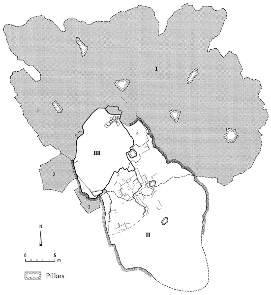
The underground complex was hewn into a limestone layer of the Senonian geological period. This layer was specifically chosen due to the softness of the stone in relation to that on the surface, and its suitability as a raw material for the manufacture of stone vessels. The complex included an ovoid entrance courtyard, 13 by 8 m, sunk 5 m into the bedrock. Two caves extended from this courtyard. Cave I, carved into the side of the entrance courtyard, slopes slightly downward at first, then forms a level, fan-shaped space. The radius of the fan grew with the progression of the quarrying, which reached a distance of 30 m from the courtyard and covered an area of 4,000 sq m. Close to the cave opening, the ceiling rose to a height of 4 m, but then sloped down toward the back of the cave, decreasing to 2 m at its rear. Due to the immense size of the space formed, the softness of the stone, and the natural cracks in the bedrock, rock pillars were left at even intervals to support the ceiling, dividing the cave into a series of large halls. Close to the opening, four relatively small chambers (1–4) were shaped from the rock. The finds from these indicate that they functioned as production workshops for stone vessels made from the raw material quarried in the inner parts of the cave. Cave II, at a higher level and extending southeast of the courtyard, was shaped like an elongated ovoid measuring 24 by 17 m with an area of c. 1,000 sq m. It too had rock pillars left to support the ceiling.
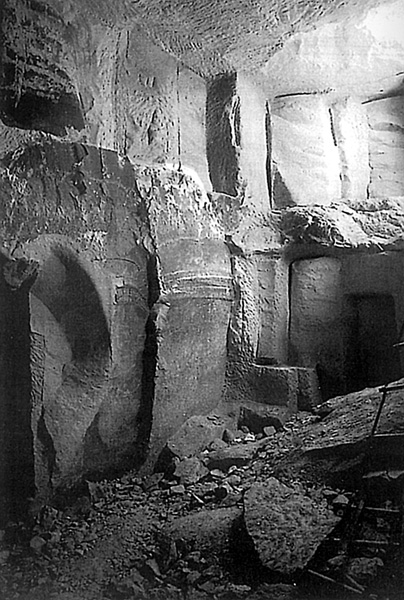
Rectangular stone blocks measuring on average 1.5 by 0.7 m were quarried from the walls, floors, and ceilings of the caves, first by cutting grooves around the required block, then prying the stone from the bedrock by metal wedges hit with hammers. This process left distinctive grooves and ridges on all the surfaces of the caves. The quarrying produced large quantities of chips that remained in piles inside the caves. For illumination, small horizontal notches were incised in the walls and flat stones were inserted to form tiny ledges upon which oil lamps were placed. Many of these improvised lamp ledges were found exposed, and telltale soot marks were discerned on the ceiling, both above the ledges and at numerous other locations.
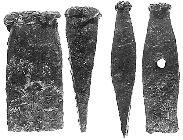
Thousands of wasters and stone cylinder cores of stone vessels were discarded at various stages of production, accumulating into huge heaps close to the openings from the entrance courtyard. They are evidence for the manufacture of tens of thousands of vessels on site. No complete vessels were found in the caves. These would have been taken for sale, presumably in the markets of nearby Jerusalem and its environs. Stone vessels were in demand due to the increased observance among Jews during this period of the ritual purity laws, according to which stone vessels, unlike the more commonly used pottery vessels, were deemed impervious to ritual impurity.
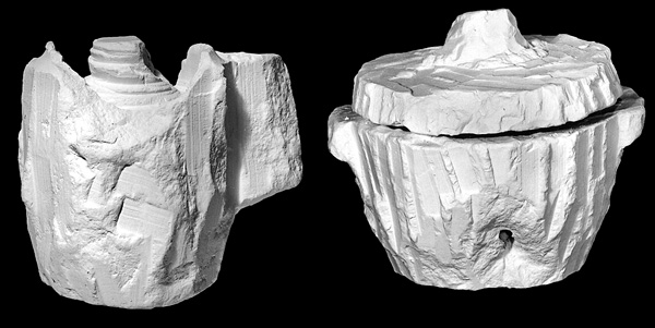
The vessel types produced in the caves included mugs (the so-called “measuring cups”) of various sizes, with one or two lug handles; and basins with rounded corners and ledge handles on the rim. Both these vessel types were chiseled from stone blocks. Also manufactured in the caves were fine table vessels and bowls of various shapes and sizes that faithfully copy ceramic forms, as well as large lathe-turned jars (kalals). Most of the vessel wasters in the caves were from the large, lathe-turned vessels. Marks on the cores from smaller vessels show that a smaller lathe was used as well. Iron pieces that were probably part of these lathes were retrieved in the excavation. Also found were fragments of unfinished ossuaries, the first evidence of a manufacturing site for such items.
The ceramics recovered from the excavation date almost exclusively to the first century CE, and consist mostly of jars and cooking pots left behind by the laborers, as well as a small number of juglets and so-called Herodian lamps. Four coins were also discovered, one from the period of the Procurator Antonius Felix and three from the First Jewish Revolt, two from the second year (67–68
THE MONASTERY OF THEODORUS AND CYRIAKOS ON MOUNT SCOPUS
An extensive salvage excavation of a large architectural complex was conducted by D. Amit, J. Seligman, and I. Zilberbod of the Israel Antiquities Authority in 1999 and 2000, following its discovery during the laying of a new road on the eastern slope of Mount Scopus. The site, covering an area of slightly more than 1 a., was part of a monastery and hostel for pilgrims and travelers passing on the Jericho–Jerusalem road during the Byzantine and Early Islamic periods. The complex was located 1.6 Roman miles from Jerusalem’s Damascus Gate, and 200 m south of the Ras Tumeim hill, which has been identified with the biblical site of Bahurim. This identification, alluded to as Baorin in the late sixth-century CE description by the Piacenza Pilgrim (Antoninus Placentinus), is strengthened by the identification of Iron Age remains on the hill. It is possible that this name came to include the nearby monastery in the Byzantine period. The complex is made up of a central courtyard (unit C); a church and associated structures (unit B); stables, storage areas, and agricultural installations (units D and E); a western wing and assembly hall (units G and H); a bathhouse (unit F); water collecting installations (unit A); and tombs.
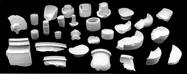
The large rectangular courtyard (unit C; 13 by 27 m) at the center of the complex is surrounded by the monks’ living quarters, visitor lodgings, the ecclesiastical center, and service areas for the animals. Entrance to the courtyard is through two corridors, one in its northwestern and the other in its southeastern corner. Under the courtyard’s paving is an intricate network of water channels that led to the site’s main water cistern (III), cut under the southern part of the courtyard.
The church and associated buildings (unit B) cover the northern part of the complex. The foundations and floor of the church have partially survived. Based on the foundations of its side walls, the original length of the church is estimated to have been c. 20 m. Limited patches of a fine polychrome geometric mosaic remain on the church floor, together with a large section of the mortar bedding of the mosaic. Parallel to the church to the north was a hall with a plastered water installation, possibly a baptismal font in the northwestern corner. West of the church and the northern hall was a courtyard, perhaps an atrium, with a simple tessellated floor and a rectangular water cistern (II) underneath. South of the courtyard and church was an elongated hall with five cist graves (T1–T5), possibly those of the monastery’s founders or clergy.
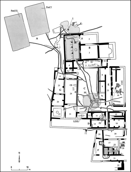
Another wing of the monastery (unit E) is built on a slope to the east of the courtyard. It appears to have been originally two stories high. Its ground floor contained two stables and a room with a circular paved area, possibly the remains of a now missing agricultural installation. The second story could have contained the living quarters of the monks or the visiting pilgrims and wayfarers.
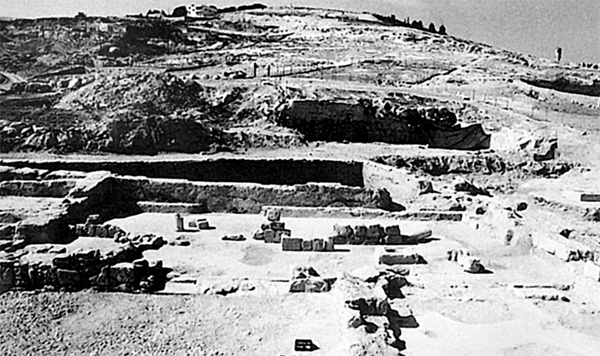
To the courtyard’s west were two parallel rows of rooms from two different phases. The western row (unit G) included an entry hall and two rooms. The main hall was paved in a polychrome mosaic boasting a floral medallion in its center. Inside the medallion is a Greek dedicatory inscription of eight lines, reading: “In the days of Theodorus, the priest and abbot (hegumen), and the monk Cyriakos this work was done.” A rectangular marble table found in the hall joins the inscription as evidence that the space served as a reception hall or a refectory.
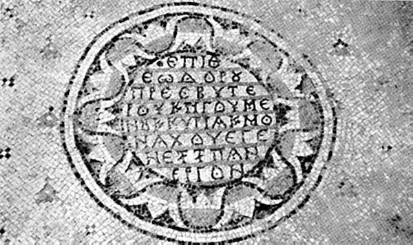
One third of the built-up area of the site is occupied by the southern wing (unit D), which consists of a series of rooms, some cut into bedrock. A rectangular hall, mostly cut into bedrock, had a hewn manger on its northern wall, showing the room to have been a stable. At a later stage, a poorly preserved bathhouse (unit F) was added south of the southern wing. Its remains include an apodyterium paved in a polychrome mosaic, and the hypocaust of its caldarium.
The monastery complex is marked by an extremely sophisticated water supply system (unit A). The system includes two huge open-air pools to the northwest, four underground cisterns, and an extensive network of channels exceeding 350 m in length within the excavated area alone. Sluice gates, of which only the slits on either side of the channels survived, controlled the flow of water between the pools and cisterns and directed the water from the monastery to the fields and orchards in the valley to the east.
The ceramics discovered at the site were mainly dated to the Byzantine (sixth–seventh centuries) and Early Islamic periods (seventh to beginning of ninth centuries
The finds and mosaic inscription are clear indications that the remains are of a large monastic complex and hostel. It would have been the last stop for pilgrims traveling on the Jericho–Jerusalem road. A segment of this road was exposed southeast of the complex, probably the point at which the road leading to the monastery branched off from the main road. The pottery, glass vessels, coins, and other artifacts uncovered in the various parts of the complex date primarily to the Byzantine and Early Islamic periods. More specifically, the central courtyard and surrounding buildings are dated by the ceramic and numismatic finds to the sixth century CE. It is clear that the bathhouse is a later addition to the southern wing of the monastery; it is dated by its finds to the Early Islamic period. The western extention of the monastery should also be assigned to this period, based on the paleographic analysis of the inscription, which indicates that the mosaic was laid no earlier than the end of the seventh to the eighth centuries CE. It is perhaps surprising that a site of this scale, so close to Jerusalem, has not been identified with any known monastery of the Byzantine period. Based on the names memorialized on the mosaic inscription, it has been provisionally named the Monastery of Theodorus and Cyriakos. The site was destroyed and abandoned in the Abbasid period, at the end of the eighth or beginning of ninth century CE.
DAVID AMIT, JON SELIGMAN, IRINA ZILBERBOD
THE JERUSALEM INTERNATIONAL CONVENTION CENTER
The site at the Jerusalem International Convention Center (Binyanei ha-Uma) is located c. 2.4 km west of the Old City of Jerusalem, just south of the ancient road leading from the Coastal Plain to Jerusalem’s Jaffa Gate. The Arab village of Sheikh Badr was located at the site until 1948. M. Avi-Yonah conducted two salvage excavations at the site in 1949 and 1968. Finds included remnants of hewn installations, pits, and pools of various sizes dated to the Herodian period. A large quantity of roof tiles and bricks bearing stamps of the Tenth Legion led Avi-Yonah to suggest that a Roman brick manufacturing kiln existed at the site. Also found were the remains of a church and monastery of the Byzantine period. A dedicatory inscription to St. George was found on the mosaic floor of a chapel immediately to the south of the monastery, prompting Avi-Yonah to identify the site as the St. George Extra-muros Monastery.
In 1967, an additional area was excavated farther to the south, on the site of what is now the Crowne Plaza Hotel. More Herodian period installations were discovered there, including two oval pottery kilns, kiln waste, an area for preparing and refining clay, quantities of prepared clay, and a deep cistern. This area was later covered by a thick fill, upon which large whitish mortaria bearing stamps of the Tenth Legion were found. In addition, the excavators unearthed a number of rubbish pits and other installations dated to the Byzantine period.
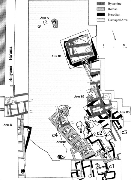
Renewed excavations were conducted at the site in 1992 by H. Goldfus and B. Arubas on behalf of the Israel Antiquities Authority. The excavation area covered nearly the entire parking lot to the east of the Convention Center. Disturbance by modern infrastructure and construction works left the remains in a fragmentary state and made it impossible to locate the church excavated by Avi-Yonah. The architectural remains belong to three main periods: (1) the Early Roman period, from the end of the Hasmonean period to the Herodian period, or the first century BCE to 70 CE; (2) the Roman period, from 70 CE to the end of the third century CE; and (3) the Byzantine period, from the fifth to the seventh centuries CE. The excavation also produced a number of random small finds dated to the Iron Age and the Persian, Abbasid, and Mameluke periods.
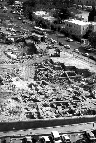
THE EARLY ROMAN PERIOD REMAINS AND KILNWORKS. A settlement existed at the site of the Convention Center at the end of the First Temple period as well as during the Persian and Hellenistic periods. Although the remnants from these periods are insufficient for determining the nature of the site, or the reason for its establishment, it may be assumed that these were closely linked to its strategic location on the main road to Jerusalem. The settlement would develop into a Jewish village that produced everyday cooking utensils for the Jerusalem area in the Early Roman or late Second Temple period.
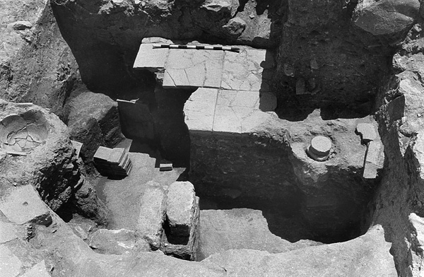
The remains from this period include agricultural and industrial installations (area A), plastered cisterns, a number of stepped pools (including some ritual baths), oval potters’ kilns and kiln waste, a few stone vessels typical of the latter part of the Second Temple period (areas B2 and B4), and a group of buildings with massive walls, separated by a narrow alley (area B3). The system of cisterns and adjoining channels (area B1) was fed by an open reservoir (15 by 15 m) typical of this period, with a corner staircase and 2-m-thick walls. The site appears to have contained one of the major pottery production installations in the Jerusalem area from the mid-first century BCE until the Roman destruction of Jerusalem
The complex went through several discernible stages of pottery production. At first it specialized in the production of high-necked cooking pots. The variety of vessels then increased gradually, and came to include cooking pots and jugs with a triangular rim, kraters with a triangular rim and a carinated shoulder (in imitation of contemporary Pompeian bronze kraters), and small round stands, among others. It may well be that the establishment of this production center, as well as the simultaneous appearance of stone and glass vessel production facilities and the increase in the number of ritual baths in Jerusalem and other Jewish sites in the region, are to be attributed to the stricter interpretation of ritual impurity laws at the time, which resulted in an increased demand for locally produced vessels for domestic use. The earliest coins from the period in question found at the site are Seleucid issues. Hasmonean, Herodian, and Nabatean coins were found as well, as were coins minted by the Roman procurators and coins of the second year of the First Jewish Revolt against the Romans (67
THE KILNWORKS OF THE TENTH ROMAN LEGION. Most of the remains from the Roman period are associated with the presence of the Tenth Legion at the site. The legion participated in quelling the First Jewish Revolt and was subsequently stationed in the Jerusalem area. Most of the excavated area (B2–B4) housed a legionary production center for building materials and pottery vessels. Both represent foreign technological, typological, and stylistic standards characteristic of finds in Rome and western Europe. The site was likely chosen by the legion due to its preexisting infrastructure for the manufacture of pottery, its relative proximity to Jerusalem, and its location next to the main road leading to and from the city, which would have facilitated transportation and distribution. The industrial complex is thus far one of a kind in the eastern Roman Empire, although many such complexes have been found in the context of the presence of a Roman legion in the West, from the Danube to Britain.
The legion used the open reservoir from the previous stage, adding a reinforcement wall on the inside, a corner staircase, and feeder channels. To the west of this production center and on the edge of the excavated area (area D), a long massive north–south wall with a 3.5-m-wide entrance was unearthed. The northern part of the wall is adjacent to the disconnected remains of a row of rooms, perhaps vestiges of a camp (castrum) for the unit stationed at the site or for the operators of the production center. The facility was divided into four functional subparts: an area for refining the clay (C1), a unit for producing wheel-made pottery (C2), an area where the clay products were dried (C3), and a series of kilns (C4).
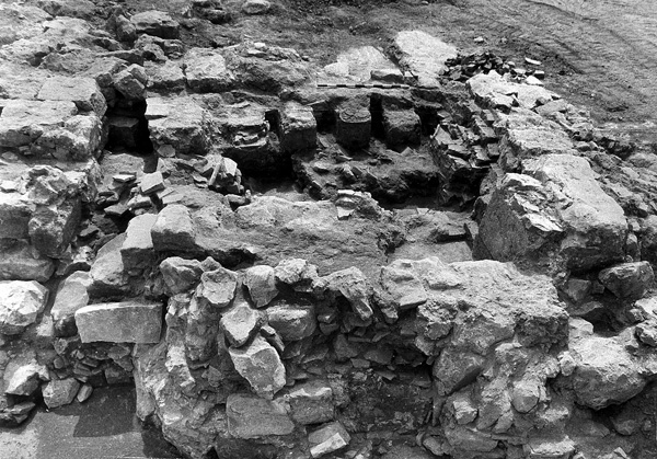
Two major construction stages can be identified. First, a continuous row of at least five uniform kilns (K1–K5) oriented along a southeast–northwest axis was constructed of mud bricks. The kilns’ stoke-holes were on their eastern sides. Most of the kilns were rectangular, c. 3 by 3.5 m; kiln K4 was originally round, c. 3 m in diameter, but was later given a rectangular form when the kilns were renovated. At some point, kilns of a different type and array were added, perhaps marking the end of use of the old kilns. A preliminary analysis of the distribution of Tenth Legion stamp impressions may help date these two stages in the operation of the kilns. In the first row of kilns, the stamp impressions are generally round and contain the name of the legion abbreviated as LEGXF and the legion’s symbols, the wild boar and the galley; this type of stamp is thought to have been in use between 70–130 CE. In the area of the later group of kilns, the stamp impressions are generally of the type with the legion’s name appearing as LXF, along with its title, ANTONINIANA; this type is usually dated to no later than the beginning of the third century CE. The small number of Roman coins unearthed points to a continuous presence at the site from the end of the First Jewish Revolt to the reign of Antoninus Pius.
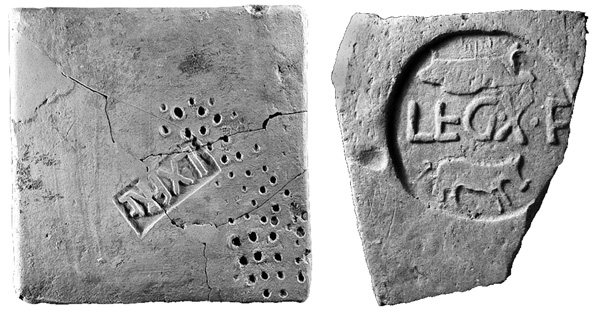
The main focus of production was on roof tiles and bricks used in the construction of bathhouse heating systems. Two common types of roof tiles were found: trapezoidal flat tiles (tegulae) with an average length of 54 cm; and rounded, elongated (c. 50-cm-long) curved tiles (imbrices), used for covering the lines of contact between adjacent tegulae. Individual specimens of tile types were also found, including a triangular roof tile, probably of a kind used in corners; a tile with a round, ridged opening in the middle, through which probably a pipe or a chimney was passed; and one end tile (antefix) molded into a human face in relief. Other materials produced on site include cylindrical clay water-pipe segments, of the type found in situ in the Jerusalem Citadel; square clay pipe segments (tubuli) for bathhouses, of the kind found in situ in the baths at Ramat
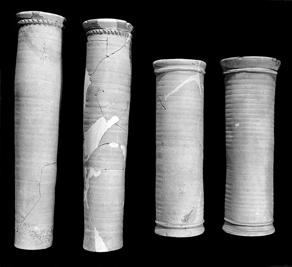
In addition to tiles and bricks, various pottery vessels were also produced at the site, including mortaria, cooking pots, pans, as well as delicate, occasionally decorated, serving dishes. Petrographic analysis of the finds showed that a number of vessel types, which had previously been encountered in the Land of Israel only as imported vessels from central and western Europe, were manufactured from local clay at this site. Among these types are pans of the orlo bifido type, red-slipped Pompeian vessels, and vessels decorated in relief, with or without slip. Two small stamp impressions found on clay vessels merit particular mention; one depicts a rosette, the other bears the acronym of the Tenth Roman Legion, LXF.
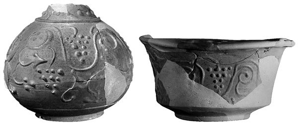
As stated, many roof tiles and bricks with the stamp impressions of the Tenth Legion have been found during excavations inside the Old City of Jerusalem and in its immediate vicinity, in particular on the southwestern hill and near the Temple Mount enclosure. These artifacts are often the only indication of construction activity inside Aelia Capitolina. They have also been found in excavations conducted at sites around Jerusalem, such as el-‘Azariya, Ramat
LATER REMAINS. Although the upper stratum of the site had been extensively excavated, as well as damaged by the extensive construction works there, the renewed excavations did succeed in unearthing the disconnected remains of a number of walls, some parallel and others perpendicular to each other, between which a stone-built subterranean tomb (area B2) was found. A corridor with steps descends from the surface on its eastern side to a hewn entrance leading into a narrow chamber. The chamber’s ceiling is built of stone slabs, with two arches on its northern side. The tomb had been broken into in the past, but Byzantine lamps and coins were found during excavations, as were Mameluke pottery and coins. On the western side of the site, very close to the Convention Center building (area D), a row of rooms paved in mosaic was unearthed, entered from a courtyard to the north. Finished marble slabs were found in one of the rooms. The area of the water reservoir (area B1) underwent major modifications in the Byzantine period. Massive new walls and constructions divided the preexisting reservoir into a number of pools and heavily plastered, vaulted cisterns. The cisterns served as underground reservoirs at the time, beneath a built-up area. They were fed by a system of channels from the west.
Fragments of architectural elements characteristic of churches were also found, such as shafts, capitals, bases, and a chancel screen. All of these should perhaps be associated with the basilica and chapel to the south, as well as the other rooms discovered by Avi-Yonah in 1949. Coins dating from the end of the fourth to the seventh centuries CE were retrieved. It would thus appear that throughout the Byzantine period there was a large monastic complex at the site. Its area was at least 70 by 50 m. Given its proximity to the main highway from Jerusalem, it may have served as a pilgrim hostel. The dedicatory inscription on the chapel’s mosaic floor reads “May the Lord, God of St. George, remember the donor.”
No significant Early Islamic period finds were found in the excavation. A single Umayyad coin and a number of Mafjar ware vessels were retrieved from the bottom of the reservoir.
BENNY ARUBAS, HAIM GOLDFUS
MOUNT ḤOẒEVIM
A farmstead of the Crusader period at Mount
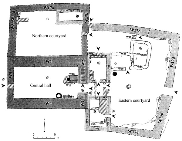
THE RAMOT FOREST
A watchtower, apparently from the Crusader period, was excavated in 1996 by A. Onn, on behalf of the Israel Antiquities Authority, in an area of agricultural terraces in the Ramot forest, in the northwestern part of the modern city of Jerusalem. The tower survives to a height of several meters, primarily due to its thick walls (1.75 m on average). Its entrance is also preserved (1.2 by 0.6 m); the lintel is one long stone. Within the structure is a staircase leading to its roof. It appears as though the tower was used in guarding over the adjacent agricultural fields.
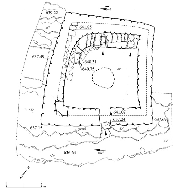
KHIRBET EL-BURJ
A Crusader village, Khirbet el-Burj (Ramot 06), was excavated on behalf of the Israel Antiquities Authority by A. Onn and Y. Rapuano in 1992 and by A. Boas and Y. Arbel in 1994. The village is located in the Ramot neighborhood, in the northern part of the modern city of Jerusalem. It was built in the twelfth century CE. It has a main street crossing the length of the village, a typical feature of European villages. Excavated at the end of this street at Khirbet el-Burj was a complete structure with two rooms, one of which faces the street. The village appears to have been resettled by Muslims after the fall of the Crusader kingdom at the end of the twelfth century.
DAN BAHAT
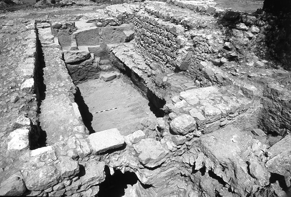
THE KATHISMA CHURCH
The Kathisma Church is located c. 350 m north of the Mar Elias monastery, its remains extending alongside the modern Jerusalem–Bethlehem road. In the nineteenth century, a large water reservoir referred to as Bir Kadismu was recorded at the site by C. R. Conder and H. H. Kitchener. This reservoir, according to E. H. Palmer, was mentioned in a late legend which tells of the star of Bethlehem that guided the three Magi who came to pay homage to the infant Jesus (Mt. 2). The accounts of the cistern and the legend appearing in writings of pilgrims were studied by T. Tobler. In 1888, von Riess identified Bir Kadismu with the Kathisma monastery and church (Kathisma meaning “seat” in Greek), which are mentioned in a number of historical sources from the sixth century onward. According to Christian sources, the monastery and church were built on the site identified in the proto-gospel of James (17:2–3) with the spot where Mary stopped to rest in the middle of her journey to Bethlehem to give birth to Jesus. The church was erected on the site to memorialize this holy place.
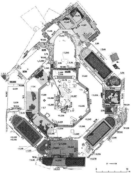
In 1951, A. M. Schneider alternatively identified the Kathisma with a site on the Ramat
The Kathisma is said to have been built c. 456 by the widow Ikalea and dedicated to Mary Theotokos (“mother of God”). In the days of Anastasius (498–518), a stone altar behind Jesus’ tomb in the Church of the Holy Sepulcher in Jerusalem was used in the celebration of the Eucharist. The altar had been constructed from stone cut from the rock on which Mary rested on the road to Bethlehem. The imperial minister Praepositus Urbikios cut a piece of stone off the rock but failed in his attempts to transfer the altar to Constantinople. The Piacenza Pilgrim, who visited the site c. 570, relates that miraculous water issued from the rock, the water having been used for eulogiai (“blessings”). The last pilgrim to describe the site was Abbot Daniel (1107/08), who identified the ruins of the church as commemorating the spot where Mary had a vision while traveling to Bethlehem (proto-gospel of James 17:2–3). According to his testimony, the stones of the defunct church had been looted by residents of nearby villages.
The Kathisma is mentioned in the Armenian lectionary and the Georgian calendar. From these sources and others, it has generally been accepted that the Kathisma was the earliest church in Jerusalem dedicated to Mary. The original feast day for Mary at the Kathisma was turned into the celebration of her Assumption, which was observed at her tomb in Gethsemane. According to B. Capelle, a feast day was added at the Kathisma in December to commemorate the extensive renovations (or the “refoundation”) of the church, which, in his opinion, took place c. 500.
Following damage to ancient ruins, three salvage excavations were conducted at the site by the Israel Antiquities Authority, under the direction of R. Avner (1993, 1997, 2000) and in cooperation with Greek Orthodox Patriarchate (the owners of the land) and the University of Athens (G. Lavas and I. Rosidis). The aim of the excavations was to fully expose the church, which had been examined in earlier excavations, in order to preserve, restore, and develop the site for tourism. There are plans for the construction next to the site of a modern chapel for pilgrims.
THE CHURCH BUILDING. The church, which was uncovered on the northern side of the site, is an octagonal structure, measuring 41 m long from west to east and 38 m wide from north to south. Its walls were poorly preserved, its plan fully ascertainable only by tracing the stones of the in-situ doorsills and the edges of the mosaic floors or their plaster bedding. The plan consists of three concentric octagons and a main apse oriented to the east, terminating in a three-sided projection.
The inner octagon is the main area of the church, built around its focal point—the holy rock, which projects c. 15 cm above the surrounding floor. Eight corner pillars separate it from an ambulatory, which is encased by the outer octagon, referred to as the “large octagon,” divided into rooms. On the western, northern, and southern sides of the large octagon are rectangular entrance halls with exterior doorways. The eastern side of the large octagon served as the presbytery. A rectangular chapel with an apse facing east is located in each of the diagonals of the large octagon. In the other four corners are pentagonal rooms connecting the chapels and the adjoining rectangular rooms of the church. Seven doorways provided passage between the large octagon and the ambulatory. The doorways were situated in the middle of the walls between the ambulatory and the large octagon.
This large edifice would was built to accommodate numerous pilgrims, its passageways allowing for the movement of considerable numbers of visitors. The structure may well have served as an architectural model for the Theotokos Church built by Zeno (c. 484) on Mount Gerizim. It would have been the only octagonal structure in existence in the Jerusalem area at the time of the construction of the Dome of the Rock, and was perhaps, as such, a source of inspiration for it.
Twenty-one soundings were conducted in nearly every part of the church, with the exception of the rooms in which the mosaic pavements were preserved in their entirety. Three superimposed mosaic floors were identified, each from a distinct phase in the history of the church. Alterations were also made to the church interior and to its eastern side, but did not change its octagonal plan.
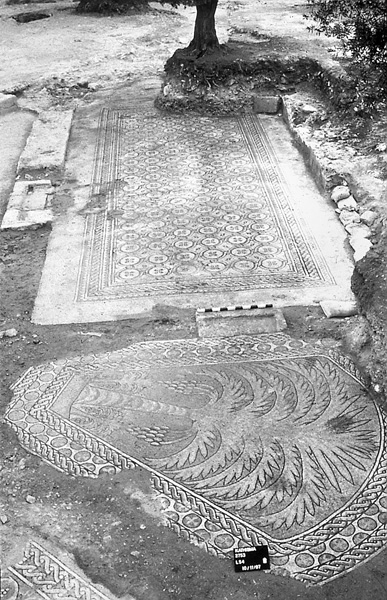
The First Phase. The original phase is dated to the middle of the fifth century, on the basis of historical sources, numismatic evidence, architectural fragments, and a comparative trigonometric study of other octagonal churches in Palestine. (This date, incidentally, does not correspond to that indicated by the study of the pottery retrieved from the church.) In this earliest phase, the main area was enclosed and separated from the ambulatory by the eight pillars mentioned above, six of which were found in situ. The apse also is attributed to this phase; beneath it a coin of the fourth–fifth centuries was retrieved. The foundations of the apse consisted of an aggregate of cement mixed with small fieldstones, apparently poured in one mass during the construction of the two presbytery walls shared by the apse and the two eastern chapels.
The chapels also belong to the original plan of the church. Because the mosaic pavements in the southern chapels were preserved in their entirety (to a level corresponding to the third phase), probes were sunk in the northern chapels only. The partial floor in the northeastern chapel is known to belong to the second phase, since it is flush with an early threshold in W106 between the chapel and the ambulatory. In the third phase the threshold was raised and a mosaic floor (L58) was laid in the ambulatory above the second-phase floor there (L343). Three soundings were conducted beneath the extant floor of the northeastern chapel, all three exposing the bedding of an earlier floor about 10 cm below the floor of the second phase. In all cases the bedding followed the outline of the walls. Another trial excavation was carried out in the northwestern chapel, under the floor adjoining the threshold of the doorway in W4. There, too, the bedding of an earlier floor followed the line of W4.
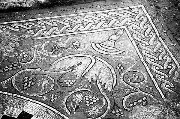
The Second Phase. The second phase is dated on the basis of numismatic evidence to the first half or the middle of the sixth century. The pottery, on the other hand, suggests a date ranging from the second half of the sixth to the beginning of the eighth centuries. In this phase, the presbytery was extended to the west into the ambulatory by means of two parallel walls, and stairs were built between the walls leading up to the presbytery. These constructions incorporated capitals and column bases apparently from the church’s original phase. Mosaic pavements were laid above the original floors and the large pillars separating the central area and the ambulatory were replaced by stylobates and a series of corner pillars. This new supporting system was narrower than the original, indicating that extensive structural renovations had taken place. The original roof of the central area, probably a wooden dome, may have been replaced as well. The reasons for the extensive renovations in the second phase are unknown. They may represent the abovementioned “refoundation,” suggested by B. Capelle to have occurred c. 500.
Also ascribable to the second phase is a ceramic conduit discovered under the bedding of the floor of this phase. Its starting point is unknown. It was found near the doorway between the ambulatory and the northeastern chapel, having crossed the ambulatory to reach the northeastern pillar, then continuing westward to the rock in the middle of the church, and emptying into a cupmark on the eastern side of the rock. Judging from its gradient, the conduit apparently conveyed water to the rock. It may have been part of an installation for holy water, the water having become sanctified when it came into contact with the rock (Piacenza Pilgrim, 28). In the eastern corner of the northeastern side of the ambulatory, beneath the mosaic floor bedding of the second phase, a subterranean chamber was uncovered. Architectural fragments of the first phase were buried within the chamber. It apparently served as a favissa. Stylistic considerations place these capital fragments within the fifth century.
The Third Phase. The third phase is dated based on coins, pottery, and mosaic style to the first half or the middle of the eighth century. The numismatic evidence indicates that the site apparently remained in use through the tenth century. In this phase, new mosaic floors were laid in most parts of the church, with the exception of the two northern chapels and the rooms in between them. On the southern side of the ambulatory the southern doorway of the large octagon was blocked and a niche facing to the south was added. The niche is identified as a
Another significant renovation was carried out in the eastern part of the church. The apse was demolished to its foundations and a structure was built above it. The largest room of this structure, L87, was carpeted in the most outstanding mosaic of the complex. It is composed of pearl medallions filled with floral motifs, reflecting clear Sassanian influences. One of the medallions is inhabited by a Sassanian crown set among floral designs. Other impressive mosaic pavements were found in the area of the southeastern corner, in L73 and L54. Both show affinities to the wall mosaics of the Dome of the Rock.
THE ARCHITECTURAL REMAINS OUTSIDE THE CHURCH. Mosaic floors and walls uncovered northeast and south of the church are attributed to a monastery. The size of this monastery, at more than 2.5 a., is indicated by the remains of two walls enclosing the site. Abutting the western, northern, and southern sides of the church were architectural complexes consisting of a large rectangular or square courtyard surrounded by three or four rectangular areas. The rooms immediately outside of the church may have served as exterior (exo-narthex) entrance halls; they belong to the second phase, as is evidenced by a sixth-century coin uncovered under a mosaic pavement on the western side of the church. In a probe made near a stylobate in the southern part of the courtyard north of the church, an earlier plastered floor was found below the stylobate foundation. Beneath the floor was a fourth–fifth-century coin similar to ones uncovered in the church under the floors of the first phase. Numerous cisterns and water installations were uncovered in the excavations. A plastered oval installation uncovered in the southern part of the site may have served as a baptismal font for infant baptisms.
An inscription was revealed in the mosaic pavement of a room (L292) southwest of the church. The inscription, which is adorned with a cross, was deciphered and dated by L. Di Segni to the ninth century, pointing to a Christian presence at the site in this period, even after part of the church had been converted to a mosque. An unusual mosaic pavement composed of alternating rows of triangular black and white tesserae was found in another room. Its stratigraphic context points to a ninth-century date.
RINA AVNER
GIV‘AT HA-MATOS
The site of Giv‘at ha-Matos (Khirbet Tabaliya) is situated on a hill, c. 500 m southeast of the Mar Elias monastery. Because the Jerusalem–Bethlehem road runs along the foot of the hill, various historical traditions are connected with the site, and it is also mentioned by pilgrims to Jerusalem. In the sixteenth century, the pilgrim Zvallardo, traveling from Jerusalem to the Mar Elias monastery, recorded seeing ruined towers on the road. H. Petermann noted a ruined tower opposite Mar Elias in 1865. Khirbet Tabaliya also appears in C. Schick and I. Benzinger’s 1896 list of sites, and the round tower at the site is marked on the map attached to their list. A survey of the site was carried out in 1981 by R. Frankel on behalf of the Department of Antiquities, now the Israel Antiquities Authority.
In 1991, excavations were conducted at Giv‘at ha-Matos by E. Kogan-Zehavi on behalf of the Israel Antiquities Authority. Six areas were opened in the northeastern sector of the site. The earliest finds on the mound were Iron Age sherds uncovered in the vicinity of a burial cave in area B. A cist tomb from the Early Roman period was also found in this area, as were the remains of a building from the Mameluke period. Building remains from the Early Roman period were uncovered in areas C and F. A quarry was found in area D. The remains of a large Byzantine period structure, which continued in use during the Mameluke period, were exposed in area G. Of special interest was the discovery in area E of the round tower (phase B) that sealed a subterranean complex (phase A), which served as the dwelling of an anchorite ascetic in the Byzantine period. The body of the ascetic was found in chains and lying in the inner chamber of the underground complex.
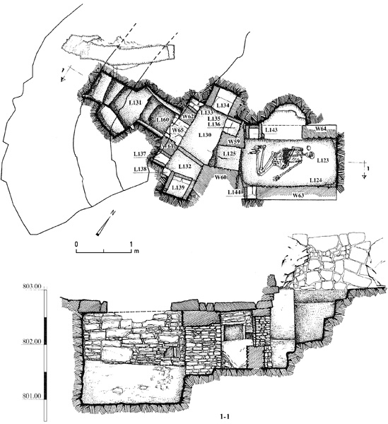
THE DWELLING OF AN ANCHORITE ASCETIC MONK. The underground complex consisted of a staircase and two chambers connected by a corridor. The lowest step of the staircase, oriented west–east, was deeper than the others (0.4 m), allowing a person to stand in front of the doorway of the complex. The doorway, built of roughly dressed stones (0.6 by 0.4 m), was covered with a thin layer of ashes, which had also penetrated the interior. The entrance led into an irregularly shaped chamber (1.2 by 0.6 m, 0.5 m high) which had eight rectangular niches, two in each of the four walls. The niches, which were not uniform in size, were lined on all four sides with flat stone slabs. Aside from a layer of ashes in some of them, the niches were empty.
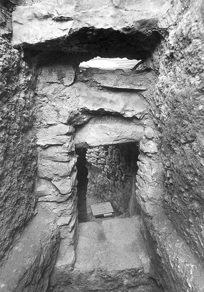
The corridor leading into the inner chamber measured 2.1 long by 1.05 m wide and was built of stone walls and a roof lined with rectangular stone slabs. It ended in a square-shaped doorway (0.47 by 0.45 m). The inner chamber, oriented northeast–southwest, was rectangular in plan and had a vaulted roof. Its floor was 0.5 m lower than the floors of the outer chamber and the corridor connecting them. Its northern and southern walls were faced with well-fitted ashlars (0.5 m above floor level). Near the entrance to the chamber, two niches were set opposite each other into the northern and southern walls. The northern niche contained an intact ceramic cup. The stone walls supporting the vaulted roof were built of roughly dressed rectangular slabs held together with light gray plaster. The top of the vault and most of the northern wall had collapsed and their debris lay on the floor of the chamber. A square cavity was cut into the upper part of the eastern wall and next to it a lamp mounted on an iron hook hung from the ceiling. Into the socket of the lamp, made of bronze wire, was inserted a glass lamp, fragments of which were found scattered on the floor.
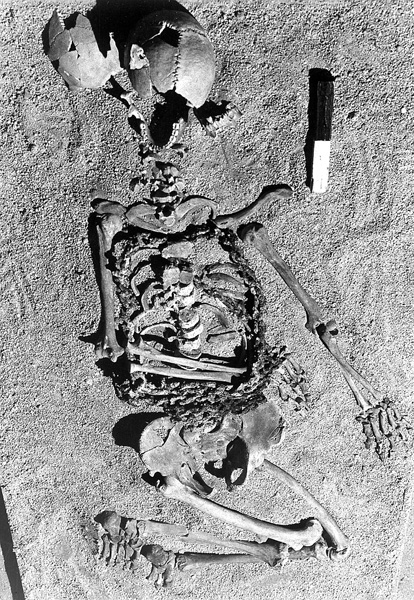
The skeleton, bound in iron chains, was found lying on its back on the floor of the inner chamber. The head faced northeast, the legs were folded, the left hand was bent and lay on the stomach or behind the back, and the right hand extended along the side of the body. The skull was found crushed, probably from the impact of the collapse of the vault and the northern wall. The skeleton belongs to a male aged 24–26, 1.6 m tall. The iron chain consisted of square links, 50 mm long. The chain was about 6 m long and weighed about 6 kg. The links were connected in such a way that they formed a “flat” chain, so as not to put undue pressure on the individual who wore them. The chain was composed of three sections and had the form of a vest. Two of the sections crossed over the back and the stomach and the third was wound four times around the pelvis area. This enabled the wearer to remove the chain when necessary. The chains that crossed the back and stomach were welded to the chain surrounding the pelvis. Next to the body were an iron knife, an iron cylinder, a fragment of an unidentified iron object, an iron belt buckle, and a pair of horseshoes. Also recovered were a jug, a small ceramic bowl dating to the sixth–eighth centuries CE, and a lamp and a glass object that have been ascribed to the Byzantine or Umayyad period.
Complexes similar to this dwelling of an anchorite ascetic monk have been found at
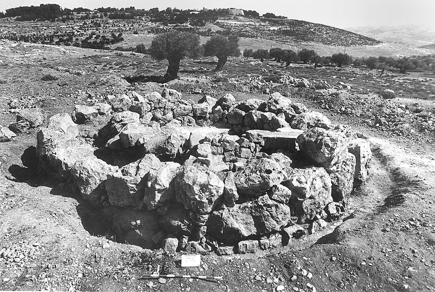
THE ROUND TOWER. Two phases were distinguished in the round structure built above the subterranean complex. In the first phase (B1), the structure (9.4 m in diameter) consisted of two concentric walls, about 1 m apart, which followed the line of the underground complex and were preserved to a height of three courses. They were constructed of large boulders. The spaces between them on the northern side were reinforced with earth and small stones; the southern side was left empty and served as a passageway to the underground complex. The building was constructed on rock that had been leveled for this purpose, around the edge of which was dug a drainage channel. The building’s entrance was on the southwestern side and consisted of two large ashlar jambs and a doorsill with a socket and a groove for attaching a door. Inside the building were two built doorways; one in the east led into the inner round space of the building and the other in the north led through a passageway to the underground complex. In the open space a floor of white lime covered the eastern side of the underground complex and the vaulted roof of the inner chamber.

The date of this building could not be established. On the lime floor lay the base of a glass vessel from the twelfth–thirteenth centuries. A 14C test of material taken from the entrance to the underground complex, which was blocked by a deposit of earth and ashes, provided a date of 1264–1385 CE. This may represent the terminus ante quem of this phase.
In the second phase (B2), the underground complex was not in use and alterations were made to the round structure, which now served as a watchtower. In the south, a staircase leading to a second story and blocking access to the underground complex was added. A 14C test revealed that the later changes in the round structure were made in the Ottoman period, between the years 1517 and 1658 CE.
Commemorative towers have been found above the graves of ascetics in Syria, and the round tower at Giv‘at ha-Matos may also have been built to honor an ascetic monk. At a later stage, apparently in the Ottoman period, it served as a watchtower.
ELENA KOGAN-ZEHAVI
General
The City of David, General
The City of David, Excavations by K. M. Kenyon
The City of David, The Eastern Slope
The Dung Gate Area
The Temple and Temple Mount
The Haram el-Sharif
The Huldah Gates Area
The Robinson’s Arch Area
The Area to the East of the Temple Mount
The Gethsemane Area
Beit Eliyahu
The Street of the Chain
The Jewish Quarter
The Church of St. Peter in Gallicantu
The Mamillah Area
The Herod’s Gate Area
The Church of the Holy Sepulcher
The Knight’s Palace Hotel
The Muristan
The Necropolis
Stone-Vessel Production Caves on Mount Scopus
The Monastery of Theodorus and Cyriakos on Mount Scopus
The Jerusalem International Convention Center
Mount Ḥozevim
The Ramot Forest
Khirbet el-Burj
The Kathisma Church
Giv‘at ha-Matos
EXCAVATIONS WITHIN THE ANCIENT CITY
1. THE CITY OF DAVID VISITORS’ CENTER
In 2005, excavations were conducted in the area of the visitors’ center on the northern part of the southeastern hill of ancient Jerusalem, identified with the biblical City of David. The excavations were directed by E. Mazar, on behalf of the Shalem Center and the Hebrew University of Jerusalem. The area had largely been excavated in 1923–1925 by J. G. Duncan and R. A. S. Macalister. It is located several meters northwest of the Stepped Stone Structure uncovered on the northeastern slope of the hill (Shiloh’s area G).