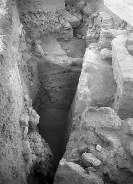
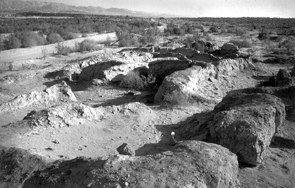
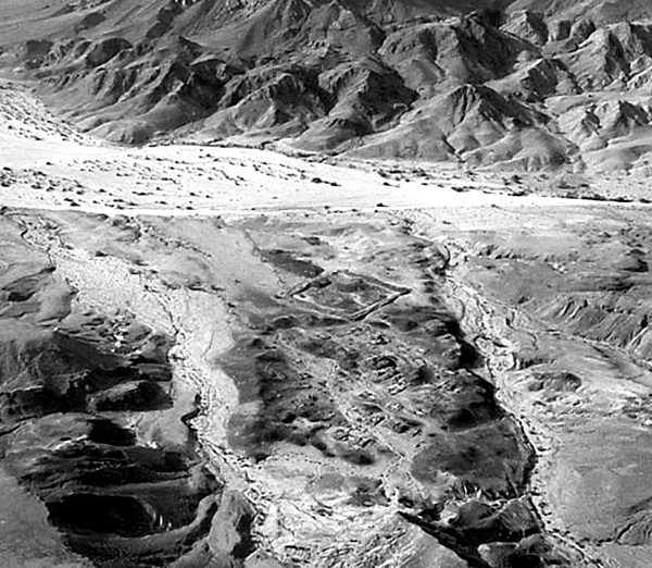
Tell Abu el-Kharaz, “the mound of the father of the beads,” is one of the most important Bronze and Iron Age sites in the central Jordan Valley. It is situated in the Gilead region, just north of Wadi Yabis, about 4 km east of the Jordan River and 6 km south of Pella. It measures 25 a. at its base and 3.7 a. at its flat summit. The finds from its various settlement periods reflect wealthy societies with far-reaching contacts. It may be identified with biblical Jabesh-gilead, which is cited frequently in relation to events connected with the battles of Kings Saul and David against the Philistines and Ammonites. Following a survey, excavations at Tell Abu el-Kharaz began in 1989 under the direction of P. M. Fischer of the University of Gothenburg, Sweden. Ten seasons have been conducted up to 2005.
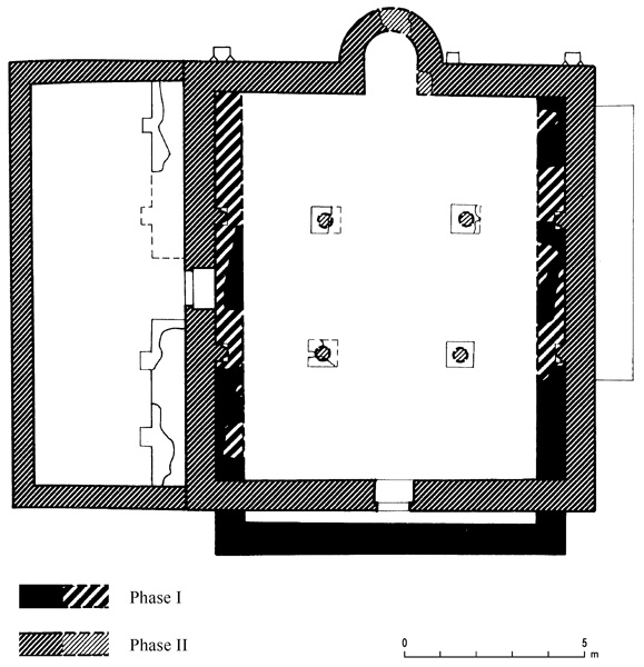
The oldest phases with architecture (phases I–III) date to the Early Bronze Age IB–II, or c. 3200–2900 BCE, as indicated by radiocarbon tests. The city was surrounded by a massive city wall of stone with superstructures of mud bricks and wood. It suffered from a number of earthquakes, repeatedly being destroyed and rebuilt. Well-preserved domestic buildings with complete pottery assemblages, copper weapons and tools, and jewelry were found. Rare organic finds include the remains of a wooden loom with the loom weights in situ, and a basket of organic fibers filled with grain. Other finds are Egyptian from the Predynastic Naqada IIlb/c cultural sphere, exemplified by cylindrical jars and mace heads. Metallic ware (formerly known as “Abydos ware”) was imported from southern Lebanon, according to petrography.
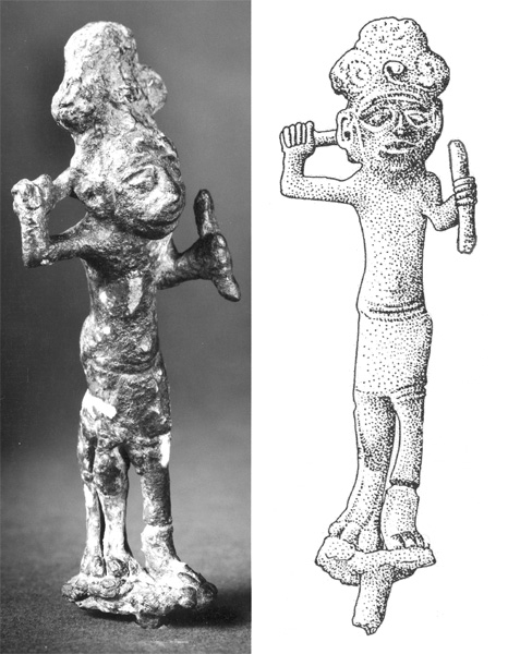
After a break of approximately 1,200 years, the next occupation, which includes phases IV/1–2 (Middle Bronze Age III) and phases V–VIII (Late Bronze Age) lasted from the seventeenth century to c. 1300 BCE, according to a series of radiocarbon dates. The city was protected by a casemate city wall. There is evidence of at least four destructions with conflagrations—after phases IV/1, IV/2, V, and VII—and possibly another after phase VIII. Numerous domestic buildings, a central bakery, and a small temple (phase VII) were found. Pottery includes chocolate-on-white ware and imported Cypriot wares of white slip I and II and base-ring I and II; small finds include a unique bronze figurine of a cat-faced smiting god with one leonine leg, jewelry, weapons, and a stamp seal of calcite depicting a tree and ibexes.
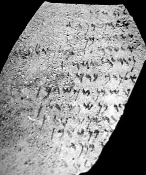
The Iron Age I remains are scanty, but substantial architecture is known from the Iron Age II, including a defensive system with towers and domestic buildings. A large square building on the summit is built of ashlars covered in white plaster. It contains an ostracon with a graffito. Small finds include pottery from Cyprus; a carved bone handle with two sphinxes; a red-painted terracotta of a smiling young male with a beard; decorated cosmetic palettes of stone; jewelry of metal, stone, and faience; and a Naukratis scarab of blue faience.
* Since the completion of Vols. 1–4, the common transliteration of several Arabic site names in Jordan has changed, including geographical terms forming parts of those names (e.g., tell, jebel, and khirbeh to tall, jabal, and khirbah, respectively). Spellings utilized in Vols. 1–4 have been maintained for consistency’s sake. E.S.
SAḤEM
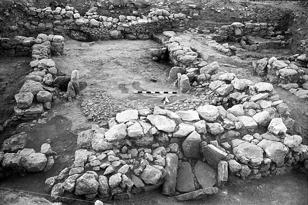
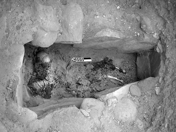
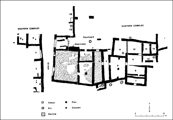
The village of Saḥem in northern Jordan lies close to the Yarmuk River, approximately 22 km northwest of Irbid, overlooking Lake Tiberias and the Golan Heights. In 1992, building activities exposed a rock-cut, L-shaped tomb rich in finds, c. 34.5 sq m in size; it was excavated in the same year. Skeletal remains were scanty and in an extremely poor state, making it impossible to estimate the number of individuals or conduct osteological investigations of any value.
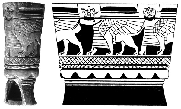
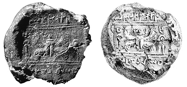
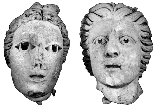
The burial gifts, more than 200 in number, included 78 ceramic vessels. “Mycenean” pottery was restricted to 21 locally produced imitations. Other objects were beads, pendants, buttons, one female stone figurine, and three clay figurines—two female humans of the “Astarte-type” with Hathor curls, and one bull. The jewelry, in gold, silver, and bronze, consisted of earrings, rings with scarabs, bracelets, and anklets. Numerous bronze weapons were retrieved, including daggers, one of them gilded; common knives; one “recurved knife,” with an animal hoof of possible Egyptian provenance; and arrowheads. Other bronze objects are a bowl, a chain, and tweezers. The rich hoard also included five scarabs, made of composite, steatite, carnelian, and rock crystal. One of the blue composite scarabs, bearing the rare coronation ceremony of the Pharaoh, had a gold setting mounted on a bronze ring with a silver wire.
The tomb seems to have been in use for two to three centuries, roughly from the end of the fifteenth century to the beginning of the twelfth century BCE, according to the pottery. The scarabs belonged to the Eighteenth and Nineteenth Dynasties, except for one heirloom scarab of the late Twelfth–early Thirteenth Dynasty. The inhabitants of Saḥem, who belonged to a specialized, prosperous, agricultural society, clearly had far-reaching contacts and could afford to purchase valuable, imported objects.
PETER M. FISCHER
ZIRA‘A, TELL
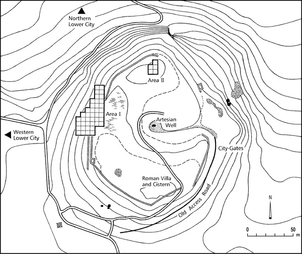
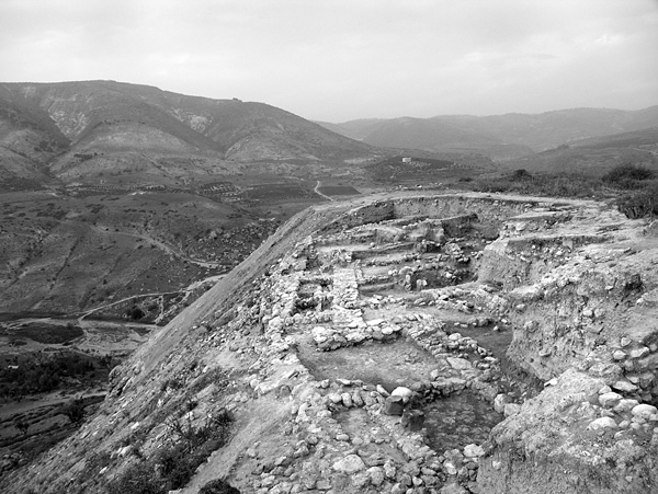
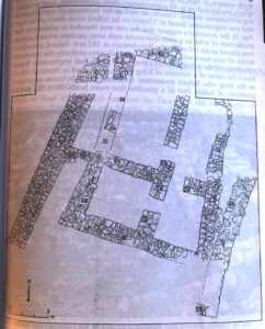
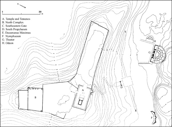
Tell Zira‘a is a large hill some 4.5 km southwest of the ancient Decapolis city of Gadara in northern Jordan. It is situated at the confluence of Wadi ‘Arab and its tributary, Wadi ez-Zaḥar. The tell rises about 25 m above the surrounding area, its settlements having been built on top of a natural limestone hill with a base roughly 240 m in diameter. The plateau of the tell measures 160 m in diameter. Its archaeological deposits are 9–12 m thick. An artesian well is located in its center.
The site’s importance stems from its strategic position along an ancient and highly important trade route. The ascent from 290 m below sea level in the Jordan Valley to c. 560 above sea level in the Irbid–Ramtha area and the hills west of Bait Ras can be made relatively easily via Wadi ‘Arab. The wadi was thus an ideal route, having connected the Jordan Valley trade routes with Transjordan, Damascus, and Mesopotamia. During the Iron Age, Tell Zira‘a belonged to the so-called “villages of Jair” (Num. 32:39–42; Dt. 3:13–15; Jos. 13:29–31; Jg. 10:3–5; 1 Kg. 4:13; 1 Chr. 2:21–23), along with Ramoth in Gilead and Camon. They are located in northern Gilead, between the mountains of ‘Ajlun and the Yarmouk River.
In 1885, G. Schumacher surveyed Wadi ‘Arab and mentioned Tell Zira‘a. N. Glueck visited Tell Zira‘a in 1942. In March 1978, a two-day archaeological salvage excavation was initiated by the Department of Antiquities of Jordan during the Wadi ‘Arab dam project. This was followed in September 1983 by a brief archaeological survey in Wadi ‘Arab supervised by J. W. Hanbury-Tenison. In August 2001, a survey on Tell Zira‘a and its surroundings was conducted by the Biblical-Archaeological Institute of Wuppertal, directed by D. Vieweger; in September 2003, he began the first excavation campaign. Since 2004, there have been two campaigns a year in a cooperative project of the Biblical-Archaeological Institute of Wuppertal and the German Protestant Institute of Archaeology in ‘Amman; in 2006, the German Protestant Institute of Archaeology in Jerusalem joined the cooperative. The project is headed by D. Vieweger and J. Häser, as part of the Gadara Region Project, an interdisciplinary study of the regional history of Gadara also conducted by the authors.
The western slope of the tell was determined to be a promising site for the rapid exposure of the stratigraphy of the tell. Accordingly, area I was opened on that slope in 2003 and enlarged to 825 sq m in three subsequent campaigns. In most of the area excavated, a depth of 4 m out of the 12 m of archaeological deposits has been reached.
The survey of the tell showed a high concentration of Early Bronze Age pottery in area I. During excavations, however, only the outer layer of a massive Early Bronze Age fortification wall could be excavated in the step trench beyond the Late Bronze Age city wall. The same part of area I yielded the remains of two Middle Bronze Age strata with residential buildings, at 2 m below the Late Bronze Age casemate wall. In the Late Bronze Age (fourteenth–thirteenth centuries BCE), at least two settlements existed on the tell, only the later of which has as of yet been exposed.
This Late Bronze Age city, with its strong fortifications, massive architecture, high percentage (5 percent) of imported pottery from Cyprus and Greece, and other noteworthy finds suggests that it was the center of a Late Bronze Age city-state. The most remarkable building of the stratum is the massive casemate wall, which fortified the settlement on the northwest flank. Three drainage channels from the residential area—originally covered with flat stone slabs—end in one of the casemates. At this point, the water flowed into a semicircular basin from where it drained into a deep, almost circular shaft built with undressed stones. A large tower was uncovered south of the casemate wall. Its southern room was divided by a small wall with two column bases. Found within it was a sizeable stone worked on its base and tapered at the top, perhaps a maṣṣeba. This find and the special layout point to a small gate sanctuary.
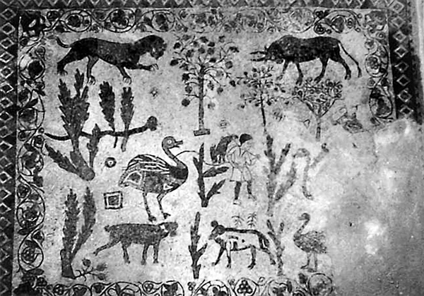
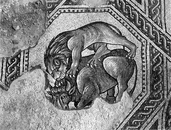
South of the tower, a 2.75-m-wide gate was discovered, leading to the lower cities north and west of the tell. To the south, the city gate was bordered by a room with a remarkable bell-shaped pit, surrounded by a paved floor and covered with a round, carefully hewn stone, 1 m in diameter. A painted pottery jar was discovered in the vicinity. The painting shows an animal scene with two lions with upraised manes, a bull, a flock of smaller animals, a scorpion, as well as coiled and uncoiled snakes together with a human figure with a lyre. There are also remains of Late Bronze Age residential buildings of remarkable size and quality; the thickness of the walls warrants the assumption that the houses originally had a second story. Originating from the Late Bronze Age stratum are one of two excavated faience cylinder seals (of the Mitannian “Common Style,” fourteenth/thirteenth century BCE), which was discovered in a stone-lined pit.
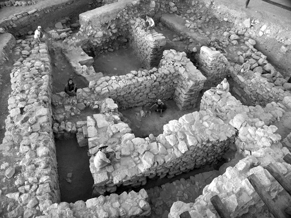
The Iron Age I (twelfth–eleventh century BCE) settlement reflects a clear cultural change. Fortification of the settlement could not be demonstrated. The inhabitants of the early Iron Age did not create their own settlement pattern, but incorporated the wall remains of their Late Bronze Age predecessors into their own, distinctive architecture. They dug several large pits for grain storage, built small walls for stables with some installations, joining simple huts to older walls. An exceptionally large oven made of mud was found in the center of the area. Also uncovered was one particularly large building, its entrance paved with stones.
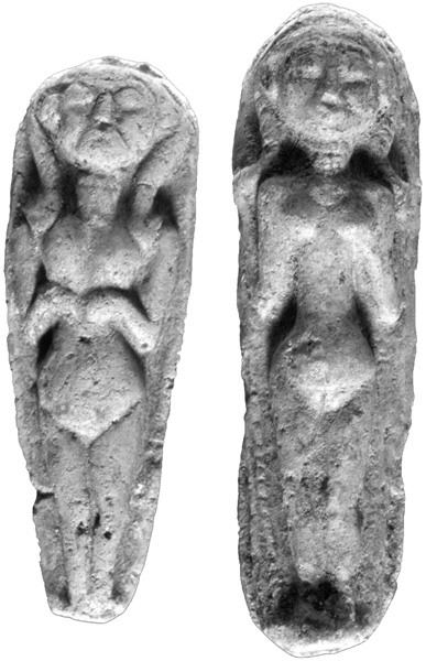
The architecture of the Iron Age IIA/B stratum (tenth–eighth centuries BCE) indicates that the tell’s population had increased and that its settlement was urban in character. Densely built structures were surrounded by a city wall. In several instances, double walls separate residential units. Multiple building phases are distinguishable. Of the earlier Iron Age II phase, three houses and a public area have been exposed. One of these houses had a workshop area comprised of four longitudinal rooms or courtyards. They yielded a metal furnace with a crucible still in situ, a well-constructed fireplace, a working platform, and six tabuns. Close to a paved courtyard and another room with three high column bases made of fieldstones, a large storage vessel and a maṣṣeba in situ were excavated. An interesting find from this stratum is a terracotta figurine depicting the goddess Astarte with a Hathor wig. Its frontal view shows the face of a woman, while its profile is of a lioness.
The houses were clearly rearranged in the later phase of the Iron Age II, though the city wall remained unchanged. At least four houses of this phase have so far been identified. A small, seated bronze figurine (7.5 cm high) with a gold appliqué, depicting the god El in blessing position, was found beneath an Iron Age wall above a burnt layer.
The area was uninhabited during the Hellenistic–Early Roman periods (fourth century BCE–first century ce). It was predominantly utilized for waste disposal facilities. Three large pits were also dug and carefully lined with stones for the storage of grain. The Roman–Byzantine period (second–seventh century ce), the uppermost stratum in area I, witnessed the construction of five houses in the area. A stone-paved street following the contour line of the slope divided the buildings into western and eastern sections. Habitation of the site in the Islamic period was limited to the area around the well and on the southeastern plateau.
DIETER VIEWEGER
THE EARLY PERIODS IN CENTRAL JORDAN
ABU THAWWAB, JEBEL
Jebel Abu Thawwab is c. 2 km east–northeast of er-Rumman on either side of the ‘Amman–Jerash highway, near the southern edge of Wadi Zarqa. It was discovered in 1983 by E. Gillet and C. Gillet, and excavated by Z. Kafafi in 1984–1985 in a few soundings. Limited excavations took place on both sides of the highway, revealing remains of the Pottery Neolithic period and the Early Bronze Age I. Very few Yarmukian sites were known in Jordan at the time the site was discovered. Fragments of stone walls were found from this period, but no coherent plan could be suggested for any buildings; pottery with a herringbone decoration and flint tools were frequent. Although bulldozers destroyed much of the Early Bronze Age I remains, stone walls formed rooms with plaster floors, pits, and cup holes. Most of the pottery of this period bears painted red crisscross lines, though gray-burnished and red-slipped wares were also found.
‘AIN GHAZAL
Five seasons of excavation at ‘Ain Ghazal (see Vol. 1, pp. 46–48) were conducted in 1993–1996 and 1998 by G. O. Rollefson and Z. Kafafi. Several phases of Pre-Pottery Neolithic B and C were found. In the east field, two temples, each with a two-room plan, seem to have originally been single-roomed and were later subdivided. In one of these, a line of standing stones (c. 60–70 cm high) in the center stood next to a platform enclosed by a line of stones and a hearth surrounded by seven stones. In the other, three pairs of standing stones supported a raised altar. In the north field, there was also a small circular cultic building with plaster floors and sub-floor channels, in addition to several apsidal rectangular structures that appear to have served some ritual purpose. Near the circular cultic structure was also a domestic two-story building consisting of at least 11 rooms on the ground floor.
Recent Yarmukian finds include a rectangular house with three rooms of equal size. East of the house, and dating to a somewhat earlier phase, was a “kitchen” with a stone platform, lined with stones set on edge. Inside were a storage jar, two grinding stones, and a hearth. A walled stepped street (dating at least to the Pre-Pottery Neolithic C and possibly the Late Pre-Pottery Neolithic B), with two gateways probably leading into courtyards, remained in use during the Yarmukian period as well. The courtyards suggest that housing density had decreased. A long, thick wall called “the Great Wall” passed through the excavated area. Down slope from the three-room house was the rectangular house, built on top of a circular one. The latest phase is represented by an ephemeral, tent-like, circular structure that may have been used as a dwelling by pastoral nomads; it is unlikely to have been an animal enclosure.
BALU‘
Balu‘ is located on the southern lip of Wadi Mujib near the modern town of Smakiya, approximately 5 km east of Jebel Shihan. It is the largest Iron Age site between Wadi Mujib and Wadi Ḥasa, and contains architectural remains from the Bronze and Iron Ages. Some suggest that the site should be identified with biblical Ar (Isaiah 15:1). A large Mameluke village called Shihan by medieval travelers was located in the southwestern portion of the site. In 1930, a large (c. 1.3-m-high) basalt stela with an Egyptian artistic scene—perhaps a “Moabite” king flanked by Egyptian deities—was found at the site by R. Head, leading J. Crowfoot to make small soundings at the site in 1933. From 1986, small-scale excavations have been conducted for several seasons, directed by U. Worschech and F. Ninow. The presence of massive piles of large basalt stones that must be cleared is a major problem for excavation.
Most of the remains on the surface date from the second half of the Iron Age II. Even the large qaṣr or palace, still preserved to a height of several meters, may be from the Iron Age. The site of this period was surrounded by a casemate wall, still preserved with some of the corbelled ceilings in the first floor rooms. A large courtyard building constructed along this wall may have been associated with the Assyrian or Babylonian presence in the area. The excavated rooms of this building, which still stand c. 1.7 m high with lintels still intact over the doorways, include a kitchen, a reception hall, and possibly a shrine room, complete with a female figurine and a small standing stone. Three other standing stones by the western wall of the house, along with broken animal figurines and burnt bones, suggest a ceremonial context. Pithoi and kraters were found in the casemate immediately north of the building. In a farmhouse to the west of the qaṣr, a pillar-type figurine holding a disk was found.
DUREIJAT
Dureijat is located 2.8 km southwest of Tell el-‘Umeiri, on a high hill with an excellent view of the Medeba (Madaba) Plain to the south, including Tell Jawa to the east, Jalul to the south, and el-‘Al to the west. It was first visited by G. Fohrer and then by the survey team of the Heshbon Expedition. The Madaba Plains Project excavated it as part of their hinterland investigations. The site includes a rectangular fortress or fortified farmstead with associated storage caves and cisterns. The pattern of an Iron Age IIC fortress or fortified farmstead reused during the Hellenistic period is found in many rural sites in the hills south of ‘Amman, such as Rujm Salim and Rujm Miryam, also excavated by the Madaba Plains Project.
Although no architecture, surfaces, or earth layers could be dated exclusively to the late Iron Age II or Persian period, the presence of such pottery on the surface, in fills, and in isolated pockets in bedrock suggests that the site was initially occupied during this period. Most of the walls of the fortress probably date to this period. The outer walls were 2.5 m thick and made of very large, partially hewn chert boulders ranging from 1.1 to 2 m in size. Because of its strategic location, it is possible that the site functioned as a military fortress or fortified farmstead.
Extensive remodeling to the fortress took place in the Hellenistic period, including the lowering of floors into the bedrock. The pottery on the bedrock surfaces was Hellenistic, during which time several of the inner walls and a room in the northeastern corner appear to have been added. A later phase from the same period included several Hellenistic lamps, cooking pots, and other Late Hellenistic ceramic forms. The site probably functioned as a fortified farmstead in this period.
GHASSUL, TULEILAT EL-
Excavation of Ghassul (see Vol. 2, pp. 506–511) was renewed in the 1990s with three seasons conducted by a team from Sydney University (Australia) led by S. Bourke. The work consisted of several small soundings on some of the hillocks that make up the site. All remains date from the Chalcolithic period, but analysis of the finds is only in a preliminary stage. The limited nature of the soundings meant that large areas of coherent architecture were not uncovered. Rather, multiple phases (sometimes up to 10) of partial houses and courtyards with pits and silos were discerned. Aside from the usual tools and ceramics at the site, another small fragment of a painted wall fresco was found.
HESHBON
Renewed excavations took place at Heshbon (see Vol. 2, pp. 626–630) under the direction of Ø. LaBianca and B. Walker in 1997, 1998, and 2001. The primary interest of the excavations, part of the Madaba Plains Project, is to clarify the Islamic occupation of the site. A few small soundings reexamined alleged earlier architecture. More of the early Iron Age I trench-pit was excavated in area D to the east of the previous excavations, confirming the date of the fill. No new data was revealed to interpret the enigmatic construction understood by some as a small moat. A very minor reevaluation of the stratigraphy in area C confirmed that Iron Age IIC walls were indeed present, as reported earlier. The Hellenistic date of the acropolis fortification wall, determined on the southern side of the fortress by soundings in the 1970s, was confirmed by two soundings on its northern and eastern sides. In the process, a faintly inscribed Thamudic inscription was discovered, engraved onto one of the large stones near the northeastern corner.
IKTANU
Iktanu is located c. 10 km northeast of the Dead Sea and c. 100 m below sea level on the southern side of Wadi Ḥisban. It spreads over two hills and overlooks the southern Jordan Valley. S. Merrill first mentioned it in 1876. Limited excavations by K. Prag took place between 1987 and 1992. The primary period of occupation was the Early Bronze Age IV (the Middle Bronze Age I), with a more limited settlement during the Iron Age II. A preliminary survey discerned up to 30 Early Bronze Age IV houses on the surface. There were two Early Bronze Age IV phases on the southern hill. Both phases, comprising an area of 628.5 sq m, included a single courtyard and workrooms stretching between two perimeter walls. Remains from three kilns and a pit containing potters’ tools suggest an industrial function of the building. A silo was found that contained a burial. Early Bronze Age IV pottery was found in both phases. Much of the Early Bronze Age IV building cut into eroded Early Bronze Age I sediment. The northern hill also contained eroded Early Bronze Age I debris. A small rectangular fort dated from the Iron Age IIC, with a possible casemate wall, stood on the northern hill. It was constructed of well-hewn boulders and measured 42.35 sq m. Associated small-scale excavations at nearby Tell Ḥammam (c. 3 km north of Iktanu) turned up Early Bronze Age III domestic remains.
JALUL, TELL
Tell Jalul is located 5 km east of Medeba (Madaba) and, along with that site, was one of the central sites of the Medeba Plain. It is also one of the largest mound sites south of ‘Amman, with a massive lower city stretching to the east of a smaller upper city, or acropolis, now a modern cemetery. Its ancient name is unknown. Since 1992, four seasons of excavation have taken place at the site, directed by R. Younker and D. Merling and under the auspices of the Madaba Plains Project. Most of the finds date from the Iron Age II, although the excavators have also found pottery from all periods of the Bronze Age and from the Iron Age I. The site may have been large, but buildings were spread out.
Excavations in field B at the eastern edge of the site uncovered an entryway and monumental approach road paved with flagstones. Two phases were clearly visible on the road, the later some 50 cm above the earlier, and both dating to the Iron Age II. There was a clear end to the approach road, but most of the gateway seems to have disappeared.
Excavations in field A on the northern side of the lower city uncovered no signs of a city wall, only masses of wind-blown earth. Surprisingly, the even slopes of the site do not appear to have formed outside a fortification wall. Excavations uncovered the first tripartite-pillared building found in Jordan, dated to the Iron Age IIC and displaying the standard features of this type of structure. Excavations beneath it produced several meters of wind-blown soil layers deposited during the Iron Age II in steeply sloping layers.
Field C, located in the center of the site, just east of the acropolis, produced a well-preserved pillared house with three long rooms dating to the Iron Age IIC or Persian period. Its floor was of bedrock. The pottery in the house was identical to that found at other Ammonite sites, such as Heshbon and ‘Umeiri. Other finds, such as figurines and a seal, are also best interpreted as Ammonite. Below the floor was a collapsed cave with several burials, contemporaneous with the house. Other wall fragments were found in field D to the south. A large depression in the southeastern part of the site, probably a water shaft, has not yet been excavated.
JAWA, TELL
Tell Jawa is located just south of ‘Amman on the left side of the ‘Amman–Medeba (Madaba) Highway, approximately 2 km north of Yaduda. It is one of the southernmost hills overlooking the Medeba Plain. Both Jalul and ‘Umeiri are visible from its summit. Excavations began in 1989 as part of the hinterland excavations of the Madaba Plains Project, directed by R. Younker and M. Daviau. Daviau directed five subsequent seasons from 1991 to 1995. Because of its prominence and proximity to the highway, many early explorers visited the site, from A. Musil in 1901 to N. Glueck in 1933. The mound’s oval top is c. 5 a. in size, surrounded by modern housing. Some researchers have suggested that the site should be identified with Mefa‘at, mentioned in literary sources. But most researchers now agree that Mefa‘at is Umm er-Rasas. There is no present consensus on the identification of the site with locations mentioned in literary sources. Remains from various periods were found, including the Iron Age I, the Iron Age II, and the late Byzantine–Early Islamic periods.
Two stone walls and a destruction layer of the Iron Age I were unearthed, but most of the Iron Age remains belong to the Iron Age IIB. A casemate wall surrounds the site in fields A, B, and E. Small fragments of houses and rooms abut the inner casemate wall, sometimes providing access into the casemates through doorways, often with jambs made of well-hewn stones. In field A, near the southwestern corner of the site, building 102 contained at least four long rooms, one of which was subdivided into three smaller rooms. Large slabs of plaster were scattered on the floor of one room. In field B, to the west, was open court 211, where broken basalt tools were refashioned. A drain with plaster lining ran from the court to the city wall. On the southern side of the site was a terrace with a gate building providing indirect access. A flanking bastion protected the entrance.
The structures along the casemate wall were examined in field E, near the northwestern corner of the site. Uncovered was a large housing complex surrounding a cistern. Nine rooms of the buildings were cleared, some sub-divided. No clear alleys or streets could be associated with the entrances to these buildings, but 16 doorways connected the rooms. A large number of domestic artifacts were found on the surfaces. Near the entrance from room 305 into room 315 was a small oven made from a cooking pot broken at the carination, turned upside down, and held in place by clay. Smashed pottery and eight unfired clay loom weights were found on the surface of room 305. The first meter of one of the walls of room 314 (W3027) was made in the quoin and pier technique, with solid or segmented columns (piers) supporting a cobble fill. Above this construction, large stretchers tied the wall together. It is not known what construction technique was utilized higher on the wall.
In field C-East, the remains of a possible gate of the Iron Age IIC, oriented north–south, were excavated on the terrace along the southern wall, north of the Iron Age IIB tower. Two chambers were found on the western side of the structure, but its eastern side was located under a modern cemetery and therefore not excavated. A roadway runs between the two projected halves. The casemate wall resumes at the northeastern corner of the gate.
On the terrace west of the gate, in field C-West, was a complete domestic building from the end of the Iron Age (building 800). With walls preserved seven and eight courses high, it is the best-preserved house from Ammonite territory so far excavated. It is rectangular in plan (18 by 14 m), slightly larger than most similar structures. One unique feature of the house is the presence of two stairways, one on the west and one on the east. The floors produced domestic finds, such as grinding stones, loom weights, spindle whorls, bins, and ovens. Less usual finds include a tridacna shell, a seal with the image of a horse, and an ostracon. These finds, along with the relatively high percentage of fine pottery (16 percent), perhaps suggest that the occupants were of high status.
LEHUN, KHIRBET EL-
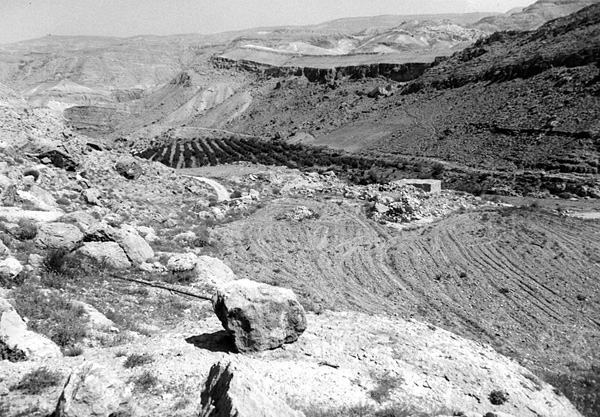
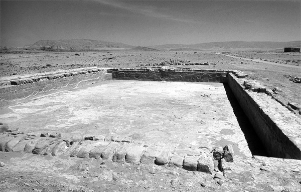
Khirbet el-Lehun is located above the cliffs of Wadi Mujib, 7 km east of Dibon, just off the road to Umm er-Rasas. It consists of a very large series of multi-period sub-sites divided by a shallow wadi, as different sectors of the site were occupied at different periods. The Classical and Islamic settlements are in the northern areas, while the Early Bronze Age and Iron Age occupants preferred the southern areas directly overlooking Wadi Mujib. R. E. Brünnow and A. von Domaszewski first mentioned the site in 1904, when they reported on their journey through Moab. Several other surveyors had visited the site prior to 1977, when a Belgian team directed by D. Homès-Fredericq began archaeological surveys and excavations, which lasted until 2000. The site has not yet been identified with an ancient toponym.
G. O. Rollefson and G. Funkhauser conducted a survey of the entire area of the site covering all periods and found a significant number of Paleolithic flint tools. There were also a few limited finds of Neolithic flints, as well as Chalcolithic pottery with mat impressions. Excavations in 1982 exposed an Early Bronze Age I tomb that contained over 100 ceramic vessels, including large hole-mouth jars with ledge handles, jugs, cups, and miniature bowls. Some of the jars contained seal impressions. The assemblage is similar to that found at Bab edh-Dhra‘ from this period. Nearby is a large (c. 15 a.) Early Bronze Age settlement, excavated from 1998 to 2000. The fortification wall, c. 5.5 m thick, encircled the site, except on the southern side, where the cliffs of Wadi Mujib provided necessary protection. The gate was most likely in the northwestern area. The houses were rectangular and a few streets were discovered as well. Reservoirs and cisterns provided water supply.
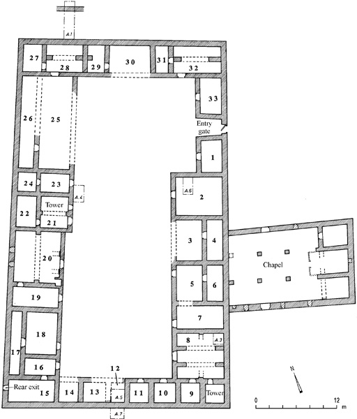
The early Iron Age I remains, sometimes labeled Late Bronze or “Transition Late Bronze/Iron Age” by the excavator, seem to relate more to the Iron Age I than to the Late Bronze Age. Spreading over an area of approximately 4 a. on a prominent spur in the southwestern portion of the site, these remains were excavated between 1986 and 1997. Long stretches of a fortification system consisting of two parallel walls have been uncovered; a few cross walls recall a casemate system. One house, the “Pillar House,” was a four-room house containing pillars to support the roof or an upper story. It was preserved to a height of 1.6 m and was situated along the western perimeter wall. A faience scarab seal was found in one of the rooms and contained a faulty spelling of Amun-Re. Other houses were found farther north along the western perimeter wall. The finds were domestic in nature and included a finely decorated cosmetic palette.
The southern portion of the early Iron Age I site contained an Iron Age II fortress. It was a courtyard structure, c. 35 by 43 m in size, that reused the earlier Iron Age I walls. Its perimeter wall was c. 1.3 m wide; four towers were built inside the corners of the wall. The surface of the courtyard, c. 20 by 30 m, was of plastered bedrock. The main entrance in the center of the northern wall was 1.5 m wide; a small postern was on the eastern side. A system of casemates was constructed along the northern, southern, and western sides. The finds—kilns, grain silos, ovens, and clay slag—represent peacetime use of the casemates. Some of the rooms inside the fortress contained pillars to support the roof. The presence of huge storage jars, cooking pots, bowls, and jugs reflects domestic activities. One item, imported from Egypt, was a New Year’s flask, made of light green glazed faience.
MEDEBA (MADABA)
The mound of ancient Medeba is in the heart of the modern city of the same name, just south of the church with the famous mosaic map (see Vol. 3, pp. 992–1001; and below, The Classical Period and The Islamic Period, in this entry). Excavations on the mound site, directed by T. Harrison, began in 1996, following a site survey in 1993. An exposed cut was examined on the southeastern slopes (field A), but the primary area of excavation was in a large open area on the western slope (field B). Early Bronze Age I/II pottery and two distinct architectural phases were found in a small sounding in field A, immediately above bedrock. Above these remains were garbage deposits containing pottery dated to the ninth and eighth centuries BCE. It appears that this area was outside the limits of settlement. In field B, a c. 6-m-wide city wall was found, more than 4 m in height in places. Such a substantial fortification implies an important settlement during the Iron Age II, but excavations have so far exposed only small expanses of living floors and walls from this period. On top of the fortification and other remains were reconstructed walls and floors from the Late Hellenistic and Early Roman/Nabatean periods.
MUDEIBI‘, KHIRBET EL-
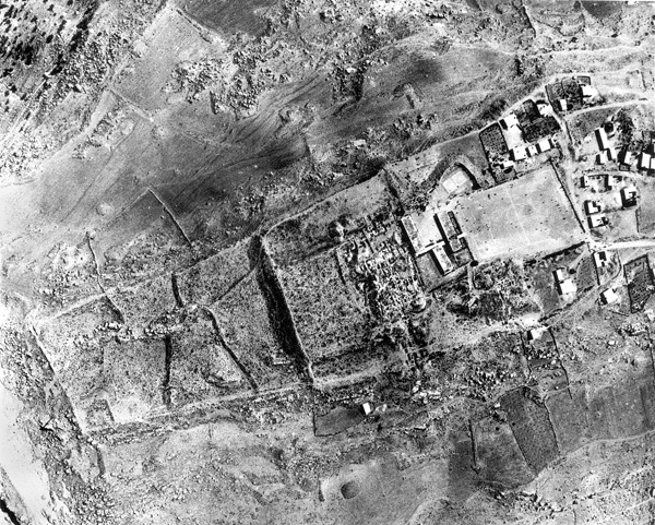
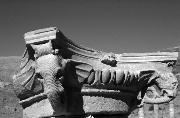
Khirbet el-Mudeibi‘ is located in the southeastern portion of the Karak plateau, on the southeastern rim of the Fajj el-‘Useikir, a geological graben extending from the desert to the vicinity of Karak, which was used as a major thoroughfare in antiquity, connecting the Desert Highway to the King’s Highway. The site has been classified as a fortress since N. Glueck’s survey in the 1930s and is well known as the site of several Proto-Aeolic or volute capitals. The Karak Resources Project, directed by G. Mattingly, has conducted three seasons of excavations in 1997, 1999, and 2001. The team has found three primary periods of occupation at the fortress, which measures c. 88 by 83 m, dating to the Iron Age II and the Byzantine and Islamic periods. The ancient name for the site is unknown, but it was most likely a royal Moabite site in the Iron Age II, its chief architectural period.
The eastern gate, where the volute capitals were located, was excavated as field B. It is one of the most monumental gates discovered so far in Iron Age Jordan. It is a four-chamber gate, 19.7 m wide and 14.5 m deep, with a passage 4.1 m wide; its chambers measure 6.7 by 3.5 m. One of the massive lintel stones was found in situ. The huge ashlars of fossiliferous limestone—some over 3 m long—are a contrast to the basalt stones of the perimeter wall and towers. A total of three complete and two fragmentary volute capitals were found in the gate area. Very little pottery was recovered from the floor of the gate, in spite of a fiery destruction, and the pottery’s date has not yet been firmly established. However, radiocarbon dates on burned cypress beams from the gate passageway yielded a date of c. 750/760 BCE. The excavator prefers a date slightly nearer the end of the eighth century for the construction of the gate. Various factors suggest that it may have never been completed before its destruction.
In fields A, C, and D, along the northern interior of the perimeter wall and inside the northwestern corner of the fortress, were fragments of Iron Age II structures, possibly domestic houses. A coherent plan is not yet ascertainable. They contained much more pottery than the gate area.
MUDEINA EL- ‘ALIYA, KHIRBET EL-
Khirbet el-Mudeina el-‘Aliya is a 5.5-a. site located on a triangular spur of the eastern Karak plateau, overlooking Wadi Mujib, c. 19 km northeast of Karak. Approach is reasonable only from the west, as the spur—some 250 m above the wadi bottom—drops precipitously to the north, east, and south. There are several nearby springs in Wadi Nukheila, a tributary of the Mujib, a natural water supply supplemented by on-site cisterns. At least six sites in the region are named Mudeina, and early explorers seem to have confused them. The one who actually visited the site seems to have been N. Glueck in 1933, but he may have conflated the features of more than one Mudeina. A project of architectural mapping and small-scale excavations, directed by B. Routledge, has conducted four seasons of work (1994, 1996, 1998, and 2000). The ancient name of the site is not known.
The well-preserved ruins of this single-period site are clearly visible on the surface. Several architectural phases were noticeable even prior to excavation. The ceramic assemblage, it seems, is limited to the end of the eleventh century BCE. The general depth of the remains ranges from 30 cm in open areas to 1.5 m within the fortifications. Walls are preserved up to 2.3 m.
The most prominent remains are those of the fortification system. Approaching the site from the west along an ancient roadway, one is met by a moat (35 m long, 19 m wide, and 5 m deep) and the ruins of a tower along its eastern side. The road leads past the moat and toward a possible gate structure, still unexcavated. The site is surrounded by a casemate wall that is still visible on the surface for most of its length. Most of the houses inside the site are attached to this perimeter wall. The central area of the site contains no structures and must have been a large open plaza or court, which the excavator calls “a ringed enclosure.” The 35–45 houses surrounding the site are constructed in plans that seem to be local variants of the typical four- and three-room houses known elsewhere. One is referred to as the “L-plan” house; it is a three-room structure, a second broad room having been added at the front. Monolithic pillars and lintel roofs were basic elements of this domestic architecture. Many of the lintels, the largest of which is c. 2 m long, remain intact. Finds on the floors of the houses were very sparse.
MUDEINA EL-MU‘ARRAJA, KHIRBET EL-
Khirbet el-Mudeina el-Mu‘arraja, located on the eastern edge of the Karak plateau, 6 km east–northeast of Smakiya, is a sister site of Khirbet el-Mudeina el-‘Aliya, c. 4.5 km to the south. The site measures c. 170 by 80 m and is situated on a towering triangular spur jutting into Wadi Mujib from the north. Its ancient name is unknown. A. Musil probably visited this site in 1897, but he refers to it simply as Mdeineh. Due to the similarities between the sites, N. Glueck may have confused some of the features of this site with those of Mudeina el-‘Aliya. E. Olávarri conducted small-scale excavations in 1976 and 1982 for the Misión Español.
The north–south oriented site closely resembles Mudeina el-‘Aliya. The ceramic assemblages of the two sites are also similar. A dry moat was dug across the narrow land bridge connecting the site to the plateau. A tower on the northern side of the moat protected access to the nearby gate on the southeastern side. The gate was simply a passage through the casemate wall, which then turned north. The excavator interpreted several of the casemate structures around the gate as towers. Most of the casemate wall can be traced along the perimeter of the site. The remains of many houses attached to the casemate wall are visible on the surface, but Olavarri excavated only one of them near the gate. Many standing monolithic columns can be seen on the surface and are present in the excavated house. There were very few small finds.
MUDEINA ETH-THAMAD, KHIRBET EL-
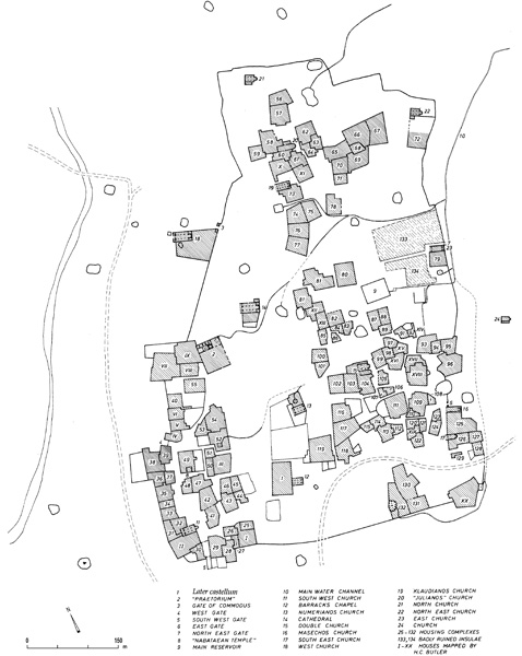
The oval site of Khirbet el-Mudeina eth-Thamad, 140 by 80 m, dominates a wide and verdant sweep of Wadi Thamad, the easternmost tributary of Wadi Wala, southeast of Medeba and northeast of Dibon. It sits in a wide basin, with watchtowers strategically placed on the hillsides surrounding it. One unique aspect is the terraced belt surrounding the western, southern, and eastern sides of the site, suggesting a moat or double-wall defensive system. A large pit at the northwestern corner may be a water shaft or simply a depression caused by a collapsed cave. A large mound of debris that seems to have been sifted through in ancient times lies to the northeast. N. Glueck visited the site in 1933 and 1938. P. M. M. Daviau is presently directing an excavation project in Wadi Thamad, which has worked at the site in 1996–1999 and 2001. The ancient name of the site is unknown.
Excavations have uncovered Iron Age II remains at the top of the site and Nabatean ruins to the north of the mound. Most of the excavations on the mound have taken place at or near its northeastern corner. The remains appear to represent essentially two strata, dated to the Iron Age IIB–C. The ceramic corpus is similar to other Moabite sites, such as Dibon. Since the dating of Moabite pottery is as yet relatively unclear, the dating of the site is based more on paleographic conclusions than on ceramic data.
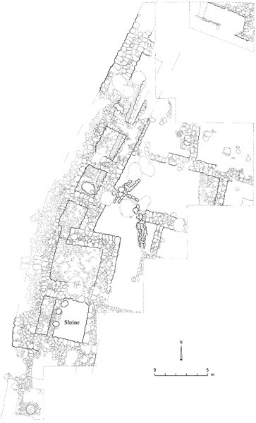
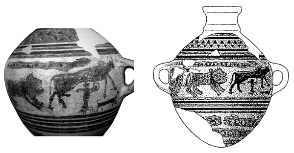
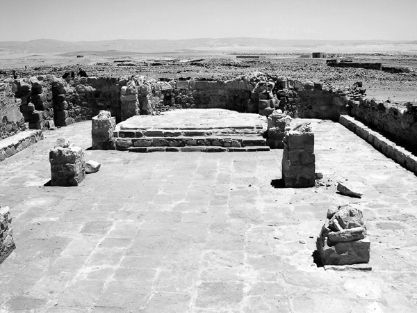
The six-chamber gate (c. 15 by 15 m) is the most striking feature of the fortification system. It is located at the northeastern corner of the site and preserved to almost 2 m in height. Remains of its wooden doors were discovered in the burnt destruction debris. Stone benches lined each side of the gate passage, while a drain ran under the passage and thresholds. The chambers contained loom weights and large stone basins fallen from the upper story, where a textile industry probably operated. One of the basins was inscribed with a crude drawing of looms, a donkey, and a palm tree. A solid stone tower stood outside the eastern half of the gate. Along the northern face of the tower were a bench and two standing stones. Considerable evidence for a military attack was found in the destruction debris of the gate. Associated with the gate was a casemate wall, excavated along the upper eastern edge of the site, apparently having surrounded the site. A plastered sloping rampart was constructed between the wall and a small rock-cut moat halfway down the mound.
Immediately to the south of the gate was a small sanctuary with benches along its walls. The room’s interior dimensions are 5.5 by 5.5 m. It produced clear evidence of cultic activity, including a flat-lying stone slab probably used as a presentation altar and three limestone altars, averaging c. 0.90 m in height. One of the altars had a drain and seems to have been used for libations; another had carbon remains from burnt offerings; the third was a slim, elaborate altar incised with an inscription in Moabite script, reading: “The incense altar that Elishama made for YSP, the daughter of ‘WT.” Other finds include lamps, female figurines, and beads.
A tripartite building south of the sanctuary contained three long rooms separated by two rows of segmented pillars. Stone vats stood in the space between the pillars. The presence of loom weights, an ivory spindle, and a bone weaving-spatula led the excavator to suggest that the building was used for the manufacture of textiles. In the middle of the building was a small stone incense altar with an incised decoration. The altar originally stood on the second story.
The excavation project in Wadi Thamad has also revealed a small wayside sanctuary c. 4 km from the site. Many figurines and parts of anthropomorphic statues were discovered. The sanctuary was contained within a perimeter wall.
NIMRIN, TELL
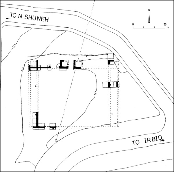
Tell Nimrin is located in South Shunah, just east of the junction of the main Salt–South Shunah highway, which cuts through the northern slope of the mound, and the Jordan Valley road. Many explorers and surveyors have visited the site, which is generally identified as Beth-Nimrah, mentioned in Numbers 32. Salvage excavations were conducted over four seasons, between 1989 and 1995, by the Tell Nimrin Project, directed by J. Flanagan, D. McCreery, and K. Yassine. They uncovered Bronze and Iron Age (including Persian) remains in limited exposure, making interpretation of the finds difficult. Remains of other periods, including the Roman, Byzantine, Early Islamic, and Middle Islamic periods, were also found. Excavations were conducted mostly in the northern and western sectors of the site.
Middle Bronze Age remains, deep and probably very extensive, were uncovered along the northern face of the site, by the highway. The earliest inhabitants occupied the site near the dawn of the Middle Bronze Age, c. 2000 BCE (stratum IA). This settlement seems to have been unfortified and consisted mostly of domestic buildings. In stratum IB, near the end of the Middle Bronze Age, a massive mud-brick perimeter wall on a stone foundation was constructed over the earlier houses; it was likely abutted by a rampart. Foundation walls to support a platform, on top of which buildings were constructed, were revealed on the northern side of the site, within the perimeter wall. New architectural features appear in stratum IC. No destruction layer is evident.
Five distinct Iron Age layers were isolated on top of the site, immediately above the Middle Bronze Age walls. They include ceramic assemblages and wall fragments from the tenth to sixth centuries BCE. The excavators attribute two phases of architecture to stratum II, dated to the tenth century, including stone walls and plaster floors. After a destruction layer, the ninth-century settlement of stratum IIIA was constructed, characterized by brick walls and a cobble surface. Several pits of stratum IIIB were later dug into these remains. A destruction layer suggests that this period ended in violence in the mid-eighth century. Extensive remains from stratum IIIC include walls, surfaces, and at least nine ovens, all seemingly dated to the eighth century. The destruction layer produced a unique krater, finely decorated with animals molded in bas-relief. Stratum IIID dates from the late eighth and early seventh centuries. A large corpus of pottery, but no architecture, from the seventh and sixth centuries indicates that the site continued to be inhabited until the end of the Iron Age.
Although most of the Persian layers were removed in modern military construction, two fragmentary phases of occupation were found in the northwestern area. Abundant pottery, ten ostraca, and one seal impression with two names most likely date to the fourth century. All ostraca contain a single name, six of which are identical: ‘ahab. Most of the other names contain the theophoric element yhw or yh.
NUMEIRA
Numeira, located 13 km south of Bab edh-Dhra‘, immediately to the east of the East Dead Sea Highway, is only c. 2.5 a. in size. The site was constructed on an alluvial fan with a perennial stream to its north. Four seasons of excavations, from 1977 to 1983, were conducted at the site by the Expedition to the Dead Sea Plain in Jordan, directed by W. Rast and R. T. Schaub and supervised by M. D. Coogan. Some salvage excavations were conducted along the west wall of the site by M. Waheeb of the Department of Antiquities of Jordan.
A field to the east of the site may have produced Early Bronze Age IB or Chalcolithic finds. The vast majority of finds is from the Early Bronze Age III, well preserved by a fiery destruction. Evidence for a pre-fortification phase was uncovered beneath the perimeter wall and under some of the house walls. Other contemporaneous dwellings were found near and beneath the east tower. Much of the fortification wall, constructed of small, rounded sandstone boulders, is clearly visible on the surface on the southern and eastern sides of the site. On the northern, it has been eroded away by the wadi. Standing to a height of 3 m, the wall was clearly constructed in several phases.
Walls inside the perimeter wall in the center of the site belong to dwellings with 17 rooms, roughly rectangular in plan. Many rooms were visible on the surface and could be easily mapped. Narrow alleys separate blocks of houses, with some buildings sharing common walls. The doors of the rooms seem to have been blocked prior to the abandonment of the site. Stone-lined pits and a unique, large clay storage container were found. The destruction preserved many finds, including wooden roofing beams, a sickle blade and part of its wooden haft, grapes complete with their skins and stems, barley grains inside bins and jars, and three male human skeletons trapped by falling walls. In room 9, more than 100 restorable vessels were found. Although the excavators have suggested that the destruction of the site was caused by an earthquake, the blocked walls and absence of finds on the floors and in the storage areas suggest many of the inhabitants had already departed prior to the devastation.
RABBATH-AMMON
Most of the work conducted on the citadel at Rabbath-Ammon since 1992 has been restoration work (see Vol. 4, pp. 1243–1251; and below, The Classical Period and The Islamic Period, in this entry). The presence of a Proto-Ionic—or Proto-Aeolian or volute—capital fragment used secondarily in a Byzantine wall near the center of the southern fortification wall has not been well publicized, although it was known for quite some time. During restoration activities on the wall in 1999 or 2000, the fragment was moved to a storeroom of the Department of Antiquities of Jordan.
The Department of Antiquities has excavated many other sites in the environs of Rabbath-Ammon, such as several round and square or rectangular towers and farmsteads, including two named Rujm el-Malfuf, one named Khildi, and others, most of which have pottery from the late Iron Age II or Persian period and the Hellenistic to Roman periods.
ṢAFUT, TELL
Tell Ṣafut is a major mound, 4.43 a. in size with a small oval summit, located on the ‘Amman–Jerash highway, 1.5 km north of Suweilah. It commands the approaches to ‘Amman from the Baq‘ah Valley, 300 m below the site. A modern highway has cut the southern slope of the mound. The site was first reported by S. Merrill in 1868, then noted in many subsequent surveys. Excavations by an international team directed by D. Wimmer have been conducted over 10 seasons since 1982. Some suggest that the site may be identified as Nobah, mentioned in Judges 8:11, but very few scholars maintain this connection today. Its modern name derives from that of a nearby village.
When the highway was constructed, bulldozers uncovered a white feature on the southern slope, identified as a rampart dated to the Middle Bronze Age, both assumptions apparently unsupported by evidence. Indeed, the excavator has suggested that the feature was part of natural bedrock. Architectural evidence for Middle Bronze Age remains has not been found, although a few sherds dating to the Middle Bronze Age IIB were retrieved in 2001.
In the Late Bronze Age, however, a substantial perimeter wall founded on bedrock encircled the site. Pottery from that period was recovered on either side of the wall. Within the settlement were uncovered the fragmentary remains of a building thought to have been a sanctuary, based on its artifacts, including a ceramic chalice and a bronze figurine of a seated, smiling deity. Traces of the gold foil that originally covered the figurine still adhere to its extended arms, one hand open, the other closed. In addition, large quantities of barley were found in the destruction debris of the structure.
Meager Iron Age I finds include several collared pithoi, but no architecture. The settlement of the Iron Age IIC and Persian period, on the other hand, was the largest at the site, perhaps as much as 10 times the size of the Late Bronze Age settlement. A casemate perimeter wall was located on the southern edge of the site, battered by a stone rampart with an earth fill. Two phases of fragmentary houses, some preserved several courses high, were uncovered near the northern edge of the site. Among the small finds is a Neo-Babylonian stamp seal depicting a worshipper standing in front of a fire altar.
SAḤAB, TELL
Today Tell Saḥab is located in a southeastern suburb of ‘Amman, approximately 12 km from the Rabbath-Ammon citadel. Its ancient mound covers an area of 125 a., situated in the transitional zone between the desert and the Transjordanian highlands. Its ancient name is unknown. R. E. Brünnow and A. von Domaszewski first surveyed the site in 1900. W. F. Albright (1929), G. L. Harding (1948), and R. Dajani (1970) excavated several tombs. M. Ibrahim directed five seasons of excavations between 1972 and 1980. The excavations were conducted in relatively small areas—open spaces of the modern town that have subsequently been built over. The site contains six main periods of settlement, extending from the Neolithic period to the Iron Age II.
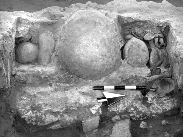
The late Neolithic and early Chalcolithic period settlement was the largest in terms of area. One domestic unit contained several rooms surrounding a courtyard. Storage features such as bins and silos or pits were abundant, some reaching 4 m in diameter, suggesting that agriculture was abundant. The presence of several caves with living surfaces contemporary to the houses suggests dimorphic lifestyles.
The site may have been used seasonally in the Early Bronze Age I, when ephemeral walls were built. Two of the earlier caves were reused in the Early Bronze Age II–III. Otherwise, only pottery in secondary deposits reflects settlement at the site in the Early Bronze Age. The earlier caves were again reused, as burial places, in the Middle Bronze Age II. A small part of a fortress with a rampart was excavated near the center of the site. In another area, the excavators discovered a very large wall that could not be associated with the fortress.
Although nearly 75 m of the perimeter wall of the Late Bronze Age town were uncovered in the western part of the settlement, very little comes from within the mound itself. Parts of a large public building from this period were uncovered south of the main settlement. The building consisted of a long wall (17 m) connected to a small room, possibly a tower. The settlement seems to have been in existence throughout the period, judging by the ceramic assemblage. Among the ceramic finds is a fifteenth-century Egyptian seal impression on a jar handle. A rich tomb from the end of this period was excavated by R. Dajani.
The Iron Age I settlement seems to have been larger than that of the Late Bronze Age, at least on the west and north. The Late Bronze Age town wall was reused for housing, and most of the excavation areas produced largely fragmentary domestic remains. However, two houses have plans that are almost complete; one contained large numbers of collared pithoi dating to the second half of the Iron Age I. Some pithoi bear seal impressions or thumb prints on the rims. The Late Bronze Age tomb excavated by R. Dajani remained in use in the Iron Age I. Another tomb, similarly dated, was found by M. Ibrahim in 1972.
The Iron Age II settlement seems to have been smaller, but better planned than the Iron Age I town. Parts of its perimeter wall were found in at least two areas. The most impressive structure was an extensive building complex, probably an industrial or commercial facility, with rectangular rooms and solid stone pillars. The finds include a large corpus of loom weights, stone weights, and a diverse group of tools and vessels made of limestone and basalt, used primarily for grinding.
SIFIYYA
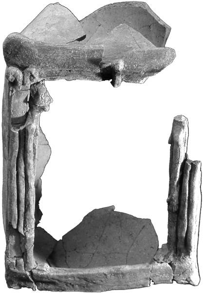
Sifiyya rests near the bottom of Wadi Mujib, on the spur of a ridge immediately east of the King’s Highway. In 1994, extensive remains of a major Neolithic site were discovered during construction. Excavations ensued in the same year; they were conducted by the Department of Archaeology at Mu‘ta University, under the direction of H. M. Mahasneh. Although surface artifacts have been found over an area of 29.5 a., the excavators estimate the site was actually roughly 5 a. in size. The flint assemblage of the site dates it to the late Pre-Pottery Neolithic B period, c. 6500–6000 BCE. Several stone building complexes have been excavated, with some walls still standing to 2 m in height. At least one complete doorframe is preserved, 0.5 m high, with stones still atop the lintel. The walls and floors of the buildings were plastered and painted red.
‘UMEIRI, TELL EL-
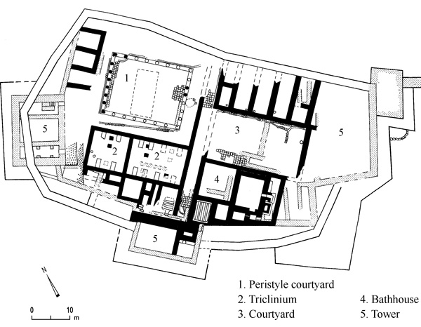
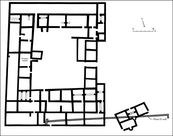
The imposing Tell el-‘Umeiri is located immediately west of the airport highway, approximately 8 km south of the Seventh (Zahran) Circle at the exit to the ‘Amman National Park. The site is mentioned by C. Warren in 1869, but N. Glueck seems to have missed it, probably because it was hidden in the hills off the main roads until 1984. The Heshbon Expedition Regional Survey rediscovered it in 1976. The Madaba Plains Project has conducted nine seasons of large-scale excavations at the site, beginning in 1984. They were directed by L. Geraty during the first two seasons, and subsequently by L. Herr and D. Clark, with L. Geraty as a consultant. Tell el-‘Umeiri is the most extensively excavated Bronze and Iron Age site in Jordan. (A survey by H. J. Franken prior to the construction of the present airport highway reported scattered Chalcolithic flints and pottery in the valley to the east of the site.) It contains over 20 strata of settlements. Redford has suggested identifying the site with Abel Keramim, mentioned in Judges 11:33, but no archaeological evidence confirms this identification. The origin of the present name is unknown.
THE BRONZE AGE. The Early Bronze Age settlement was the largest at the site, extending down all slopes. At no point, however, was it fortified. Early Bronze Age I pottery was found in field D, the primary Early Bronze Age field on the southern slope, but the most significant find from the beginning of the Early Bronze Age is the dolmen in field K on the lower southeastern slope. Covered by later Early Bronze Age debris from the settlement above and lacking a capstone, its well-preserved contents included secondary burials of at least 20 individuals. There were also 20 complete ceramic vessels, as well as beads, flint tools, and a few mace heads. Up to six plastered and pebbled surfaces surrounded the dolmen, incorporating bedrock in a series of stepped terraces. A broad, flat-lying stone was placed on one surface and jars were embedded in others. The dolmen must have been used for ceremonial activities over a long period.
Early Bronze Age II–III domestic architecture appeared primarily in field D, but also in field C, on the northern slope. Several phases of building and rebuilding were discovered. A house complex found virtually complete was constructed during the last phase, toward the end of the Early Bronze Age III. It included a cobbled courtyard and bins, perhaps to keep flocks. Next to its courtyard were a storage room, which contained 30 ceramic vessels; and a kitchen, with a hearth embedded in a bench or counter. A narrow alleyway separated the house from another to its west. On the other side of another alleyway, running along the northern side of the house, was a terrace wall that supported a house at a higher level.
The transition to the Early Bronze Age IV (the Middle Bronze Age I) saw a significant abatement in architecture. Parts of two eroded one-room houses, 4 m apart, contained a central pillar and mortars embedded in the floors. The remains were so close to the surface that only sub-topsoil could be associated with them. However, these layers yielded Early Bronze Age IV pottery, leading the excavators to attribute the walls to that period. The site seems to have been abandoned during most of the Early Bronze Age IV, although a cemetery that contained shaft tombs with burials and Early Bronze Age IV pottery was revealed on the other side of the highway, to the east. Another cemetery with shaft tombs and Early Bronze Age IV pottery was located c. 3 km to the south.
Although a few pottery sherds appear to date to the Middle Bronze Age IIA, no clear architectural remains are found again until the end of the Middle Bronze Age IIB (the Middle Bronze Age IIC). The inhabitants fortified the site at the western connection to a ridge, digging a dry moat through the ridge to an approximate depth of 5 m then constructing a 10-m-high earthen rampart from the eastern edge of the moat. Although the remains of a tower have been found at the northwestern corner of the site, no evidence of a wall on top of the rampart has been located. Only fragments of walls from various buildings have been found, some constructed of cyclopean stones, others of bricks with stone foundations. A plastered pool was uncovered in the corner of one room. Middle Bronze Age IIB surfaces contained a high proportion of chipped limestone, giving them a white hue. On the southeastern slope a rock-cut cave-tomb with parts of 17 burials was excavated. Several of the Early Bronze Age IV shaft tombs mentioned above were put to reuse toward the end of the Middle Bronze Age II.
The Late Bronze Age settlement seems to have made use of the Middle Bronze Age fortification system. There is little evidence for Late Bronze Age I remains, but the Middle Bronze Age II settlement may have continued into that period. Late Bronze Age II wall fragments have been found at several locations, but only in the northwestern corner are the finds coherent enough to be described in detail. In that area the remains of at least four rooms of a palatial building, surrounded by its own perimeter wall, are preserved to a height of over 3 m. The small boulders in the walls are often cut to look like bricks. The floors have so far been completely bereft of finds, but the pottery within the collapsed bricks of the second story walls dates from the Late Bronze Age IIA and B, and includes a few Mycenean and Cypriot sherds.
—–
THE IRON AGE. During the transition to the Iron Age there was a short-lived settlement at the site, destroyed in an earthquake. Its remains are seen in the fill debris of the next major occupational phase. The earthquake seems to have occurred around 1200 BCE. It is evidenced by the collapse of a huge slab of bedrock beneath the Middle Bronze Age II rampart, causing the rapid erosion of the rampart. Virtually all the north–south Late Bronze Age walls at the site were significantly damaged as well, reduced to rubble or shaken so that rows of walls lean in different directions. The seismic wave thus seems to have traveled west to east, or vice-versa.
The destruction resulted in a massive rebuilding of the settlement, the remains of which are among the best-preserved Iron Age I architecture in the Holy Land. The builders removed all but 1 m of eroded debris from the moat. They then constructed a huge retaining wall on the eastern side of the moat and laid a new rampart, 1.5 m higher than the earlier one. The rampart ascended to a new perimeter wall founded on top of the Middle Bronze Age II rampart and incorporating the Middle Bronze Age II tower at the northwestern corner. The city gate may have been located where the perimeter wall curves into the site and is paralleled by a second wall to the south, leaving an opening 3–4 m wide.
Dwellings were constructed, or reconstructed, inside the perimeter wall. Two of these, buildings A and B, have thus far been completely excavated. Building B was a typical four-room house with an added front courtyard. There is abundant evidence that it stood two stories high: the stone walls were preserved to a height of 1.5 m, and the space between them was filled with collapsed bricks from the second story. The preserved finds reflect the way of life of its inhabitants. They include piles of barley complete with insect parasites, shanks of large mammals, over 70 collared pithoi (all from the broadroom and some still containing barley), a hearth, grinding implements, a roof roller, and an alabaster vessel. Six bronze weapons suggest that the destruction was caused by a military attack. Indeed, the burnt bones of four male humans, probably defenders, were found in the broadroom, suggesting that they were killed while still on the roof. They were burned in the ensuing fire, their bones spread about when the building collapsed.
The second house, building A, is just to the south of building B. It was probably made of four rooms as well, but not in the usual four-room plan. A courtyard may have stood to its east. Its three wide broadrooms are positioned side by side. The easternmost was domestic in function, with a hearth, grinding tools, and two bins associated with a dirt floor. Three pillars separated that room from a smaller, narrower broadroom paved with flagstones, in which a rectangular standing stone approximately 1 m high leans against the room’s western wall. A similar stone lay in front of it, perhaps functioning as a presentation altar. A chalice was the only sign of cultic activity in the associated debris. The third broadroom, next to the perimeter wall, contained a small stepped platform with a plastered top. This could have functioned as a presentation altar or as a platform for a ladder to the second floor. Also in the room were five or six collared pithoi. Just south of the room with the standing stone, a small alcove contained another standing stone, leaning against the back wall, and seven others, lying parallel on the floor. It is clear that this building was used for both domestic and ceremonial activities. It was destroyed at the same time as building B. Signs of this destruction were found at other locations on the site at well.
To the east of building B was a huge stone-lined pit, c. 2 m wide and at least 7 m long. It was probably a refuse pit for buildings A and B, as well as for other buildings in the area. The pit was filled with sediment rich in bones, numbering over 25,000, as well as broken objects and cooking pots. The bones were mostly from meat-producing animal quarters. Sheep and goat bones were the most copious, but there were also gazelle, pig, cattle, lion, bear, and Nile perch bones.
The late twelfth and eleventh centuries saw an apparent reduction in settlement intensity following the huge destruction of the early Iron Age I settlement. Buildings were constructed on top of the two earlier houses, including a storehouse with 18 collared pithoi, vessels that clearly developed typologically from those beneath the destruction. There was also a small square room with two pillars; it had been filled completely with fine ash. The most interesting remains were found in field H near the southwestern corner of the site, very near the postulated gate of the earlier stratum, which may have been reused during this period. Massive stones seem to have formed pillars and walls of an open courtyard that contained numerous cultic items, such as multiple model shrines and figurines. Five large flat boulders lying in a row appear to have been a focal point of the courtyard. There was a series of cobble and plaster floors, the lowest containing late Iron Age I pottery and the upper floors yielding pottery of the Iron Age IIA. Signs of a conflagration lay over half the upper floor, especially around the five flat boulders in the north. Sherds from pithoi and storage jars were also found directly on the floor. Earlier cultic courtyards may lie beneath. The Iron Age II floors of the cultic courtyard are the best-preserved features of that period, the settlement of which was apparently not significant. Iron Age II pottery and a few architectural fragments have been found.
The most prosperous period at the site was the Iron Age IIC and Persian period. Paleography, iconography, ceramic typology, and other indicators all suggest that intensive reoccupation began during the first half of the sixth century. In light of a hinterland survey conducted by the excavators, which has located up to 40 contemporary rural, agricultural, wine-producing settlements around ‘Umeiri; as well as the existence of over 80 seals and seal impressions found at ‘Umeiri so far (albeit some dated to the Iron Age I), the excavators suggest that the site was founded to administer the production of wine as a state-sponsored cash crop, perhaps when Ammon was placed under tribute by the Babylonians in 582 BCE. Indeed, a massive series of structures with walls over 1 m thick were probably the basement structures of the administrative center. One of the seal impressions found bears the name of a minister of King Baalis, mentioned in Jeremiah 40:14 as the king who helped assassinate Gedeliah, the Babylonian-appointed governor of Judah. Part of a possible four-room house from this period was discovered in the eastern part of the site, in field F; and other fragments of domestic buildings were found in field L at the southern edge of the top of the mound.
The administrative complex was used without interruption into the early Persian period. Four seal impressions on jar handles record the names of the province of Ammon and of the provincial treasurer or governor. Likewise, the ceramic assemblage from the Iron Age IIC continued into the Persian period with little or no interruption. The assemblage included slipped and burnished bowls mixed with Attic sherds. Most remarkable in this Ammonite assemblage are the many varieties of black-burnished bowls and some very thin-walled, fine pottery. Human and animal figurines were frequent in this period as well.
THE LATER PERIODS. Later wall fragments from domestic buildings were constructed over the ruins of the administrative complex, suggesting that at some point during the Persian period the settlement became primarily domestic. Three or four rooms of an Early Hellenistic period building, probably an isolated rural agricultural settlement, reused late Iron Age II or Persian period walls in field L. On the floors were tools for food production, as well as pottery, including lamps, jars, jugs, bowls, and plates. Remarkable were the large numbers of complete handmade juglets, very similar to Iron Age II wheel-made forms. Hellenistic pits were found at other locations. At the base of the southeastern slope of the mound was found a tomb with a Greek inscription naming the entombed.
Limited agricultural settlements from later periods were located at various spots. An Early Roman Jewish villa probably existed at the northwestern corner of the site, its remains consisting solely of a plastered and stepped mikveh. A Byzantine agricultural settlement was located at the eastern crown of the site, while Early Islamic pottery was found everywhere, deposited during the fertilization of agricultural fields. A few Middle and Late Islamic sherds were retrieved from topsoil.
LARRY G. HERR
THE EARLY PERIODS IN SOUTHERN JORDAN
INTRODUCTION
South of Wadi Ḥasa, which runs into the Dead Sea, the topography of Transjordan from west to east consists of Wadi Arabah, the Edomite or southern Transjordanian plateau, and the Arabian desert. Wadi Arabah, part of the Great Rift Valley system, extends for 163 km from the Dead Sea to the Gulf of ‘Aqaba, and changes in altitude from c. 400 m below sea level at the Dead Sea to 200 m above sea level near Gharandal, and eventually to sea level at ‘Aqaba. On the east, the Edomite plateau rises to an average of 1,500 m above sea level, with a maximum elevation of 1,727 m near Ṭayyiba. South of Ras en-Naqb, the topography suddenly drops by almost 600 m, sloping towards the Ḥisma–el-Quweira Depression at the western end of Wadi Ḥisma.
Geologically, this area is a mixture of Pre-Cambrian, Cambrian, and Cretaceous rocks, mostly granite, sandstone, and limestone, with overlying Pleistocene lacustrine, fluvial and aeolian sediments, and basalt flows. Temperatures range from below zero to 25 degrees Celsius in winter, and 40 or 50 degrees in summer. The present average rainfall is about 40–50 mm annually at ‘Aqaba, rising to 200–300 mm at the Dead Sea. There is sufficient rainfall for dry-farming in years of average rainfall. The main crops are barley, lentil, and chickpea, with some wheat. Olives, grapes, apples, and citrus are also cultivated. The natural vegetation of the plateau is mixed grassland, with some surviving oak and juniper.
EXPLORATION
Since 1990, there have been several surveys of the region, some systematic and some period-specific. Systematic surveys have covered the southern Ghawr and northeast Arabah, and the area between Bozrah and Jurf ed-Darawish (B. MacDonald); Wadi Feinan (G. W. Barker); Wadis Fidan, Ghuweib, and Jariya (T. E. Levy and R. B. Adams); Wadis Dana and Feinan (G. Findlater); the area around Jebel Harun in Petra (the Finnish Jabal Harun Project); and southeast Arabah (A. M. Smith). Period-specific surveys and soundings have elucidated the early prehistory of Wadi Ḥasa (G. Clark, N. R. Coinman, D. Olszewski); the prehistory of the Ḥisma and the southern Arabah (D. O. Henry); the Early Bronze Age, the Iron Age, and Roman sites in Wadi Ḥasa (P. Bienkowski); the Iron Age to Byzantine site of Fifa (N. Lapp); and Iron Age to Islamic sites in the Petra area (M. Lindner).
Excavations have been carried out, since 1990, at the Neolithic sites of Ba‘ja, Dhra‘, and ‘Ein el-Jammam; and at Chalcolithic sites near ‘Aqaba. M. L. Mussell reexcavated the Iron Age/Persian site at Tell el-Kheleifeh, originally excavated in the 1930s by N. Glueck. The archaeology of the Feinan region and its copper mining sites is discussed separately below.
THE PALEOLITHIC AND EPIPALEOLITHIC PERIODS
Survey and excavation in Wadi Ḥasa, concentrating on the early prehistoric periods, began in 1984 with the Wadi Ḥasa Paleolithic Project (G. Clark); and developed with the Wadi Ḥasa North Bank Survey in 1992; and later, with the Eastern Ḥasa Late Pleistocene Project (N. Coinman and D. Olszewski). The model for human use of this area in early prehistory proposed by these researchers is a diverse array of mobility strategies reflecting human adaptation to the changing lake and marsh systems that characterized this region. Middle Paleolithic sites in Wadi Ḥasa are the ‘Ein Dufla rock-shelter, with 20 small hearths and two pits reflecting fairly intensive occupation; and Wadi Ḥasa 621, an open site on the ancient shoreline of the Pleistocene Lake Ḥasa, probably a relatively ephemeral campsite. Upper Paleolithic sites are the early Ahmarian Ṭor Ṣadaf rock-shelter and the open site of Tha‘lab el-Buḥeira. The late Ahmarian has been identified at the multi-component rock-shelter site of Yutil el-Ḥasa (late Ahmarian, early Epipaleolithic/Madamaghan, and late Epipaleolithic/early Natufian), and the large open site of ‘Ein el-Buḥeira. The early Epipaleolithic is found at Ṭor Ṣaghir, a small rock-shelter, and at Ṭor eṭ-Ṭariq, a series of occupations overlain by later Neolithic deposits in an open-air site on the shore of the Pleistocene lake. The late Epipaleolithic (early Natufian) is found at Ṭabaqa, an open-air site situated on a terrace overlooking the confluence of Wadi Ahmar and Wadi Ḥasa, probably to be identified as a base camp occupied on a seasonal basis for the exploitation of cereal grasses; a possible associated task site is the nearby Wadi Ḥasa 1021.
Survey and excavations by D. O. Henry at over 100 prehistoric sites in Wadi Ḥisma and Wadi Arabah represent all periods from the Lower Paleolithic to the Chalcolithic. Henry’s model proposes a pattern, persisting from the Middle Paleolithic to the Chalcolithic, of a transhumant cycle, a seasonal movement between different elevations, in which larger groups regularly revisited residential camps for short periods, then dispersed for longer periods into ephemeral camps. An alternative might be variable degrees of mobility at different elevations due to different resource bases. Transhumance was briefly abandoned during the Natufian period, with the emergence of sedentary foraging. Features such as hearths, groundstone items, and structures characterize long-term camp sites.
At Wadi Qalkha (J401), a surface assemblage of the Lower Paleolithic (Late Acheulean) was found, consisting of only 59 artifacts, hand axes, and Levallois flakes.
Several sites in the Wadi Ḥisma area have Levantine Mousterian (Middle Paleolithic) horizons. All are clustered in the Jebel Qalkha area at lower elevations, except for the high-elevation site of Ṭor Sabiha. All but one (J447, an open site) are associated with caves, rock-shelters, or shallow overhanging cliffs. Only two of the sites, Ṭor Faraj C (J430) and Ṭor Sabiha C, have been investigated in detail. Levallois points and tools on blades dominate the assemblages. Ṭor Faraj is a large rock-shelter at the lower edge of the piedmont, with unlined hearths, perhaps a winter camp with seasonal water available. Ṭor Sabiha is a small shallow cave at the upper edge of the piedmont, which may have served as a warm season camp, with year-round availability of water in the form of springs on the plateau. J603, an open site, and J604, a rock-shelter, are lower elevation sites in the wadis leading to Wadi Arabah.
Of the Upper Paleolithic (Levantine Aurignacian (?) and Ahmarian), six sites are located on terraces of rock-shelters situated along the steep walls of canyons in the Jebel Qalkha area, and two in Wadi Gharandal leading towards Wadi Arabah. The assemblages are dominated by end-scrapers and burins. More extensive work at Ṭor Hamar (J431) revealed a deep deposit with Levantine Mousterian, Upper Paleolithic (Early Ahmarian), and Epipaleolithic horizons.
The Epipaleolithic (Qalkhan, Kebaran, Hamran, Natufian, Mushabian/Madamaghan—each distinguished by characteristic microburin production of bladelets) sites are located in both open and sheltered settings in the lowlands and piedmont, some with hearths, pestles and mortars, and possible petroglyphs.
THE NEOLITHIC PERIOD
Dhra‘ is located east of the Early Bronze Age site of Bab edh-Dhra‘, at the southeastern end of the Dead Sea. Dhra‘ was first sounded by C.-M. Bennett in 1979, and excavated on a small scale in 1994 by I. Kuijt and H. Mahasneh. Since 2001, there have been ongoing excavations at the site by W. Finlayson, I. Kuijt, and others. It is the only apparently sedentary village from the Pre-Pottery Neolithic A known outside of the Mediterranean woodland. Occupied in both the early and late phases of the period, it was a relatively large village (6,500 sq m), with outstanding preservation of oval and circular stone and mud structures, ground and chipped stone, and faunal and macro-botanical remains. One well-preserved distinctive structure has a number of upright stones with notches in their tops, arranged in lines, suggesting that they supported wooden beams. Other potential Pre-Pottery Neolithic A features are associated stone and mud structures and plaster-lined pits and refuse areas. Later Pottery Neolithic features include the remains of two structures, two large pits, a large reused stone bin, and the remains of three small plaster-lined pits.
‘Ein el-Jammam is a medium-sized farming village from the late Pre-Pottery Neolithic B–C and Pottery Neolithic with well-preserved walls standing to 3 m in height, situated near Ras en-Naqb. It was excavated in 1995–1996. The late Pre-Pottery Neolithic B buildings used free-standing pillars that were placed in the center of rooms or as pilasters; one room also had small niches in the wall, one with the remains of a goat skull, and a sub-floor burial. The Pre-Pottery Neolithic C architecture was similar, but used limestone cobbles for the floors. The Pottery Neolithic occupation adopted a curvilinear floor plan with well-constructed walls.
Ba‘ja is a late Pre-Pottery Neolithic B site north of Petra, excavated in 1997, with rectangular and polygonal rooms around courtyard-like open spaces. There appear to be no open spaces between structures; connections between rooms were through wall openings or large central rooms or courtyards, or via the rooftops. One structure has two stories. Where the topography dictated it, the ground plan of the smaller rooms became curvilinear or polygonal.
D. O. Henry’s work in Wadi Ḥisma and Wadi Arabah incorporated two Neolithic sites. Jebel Queisa (J24), situated on the terrace of a rock-shelter, has a Neolithic horizon underlying a Chalcolithic deposit. Its ephemeral occupation and lack of permanent water source suggest it was a hunting camp or vantage post. J608, a Late Neolithic rock-shelter in Wadi Nukheila, which leads to Wadi Arabah, has stone-lined fire pits, querns, and grinding slabs.
THE CHALCOLITHIC PERIOD AND EARLY BRONZE AGE
Tell Ḥujeirat el-Ghuzlan, Wadi Yutum B, and Tell el-Magaṣṣ have been surveyed and excavated by the University of Jordan and the Deutsches Archäologisches Institut since 1998, with the objective of investigating the Chalcolithic period and the Early Bronze Age in the area of the southern Jordanian port of ‘Aqaba. The site of Tell Ḥujeirat el-Ghuzlan is located on the northern edge of the modern town in the middle of the Wadi Yutum fan, close to the contemporary site of Tell el-Magaṣṣ. In addition, geoarchaeological drillings were carried out near the present shore of the Gulf of ‘Aqaba at Tell el-Kheleifeh, indicating that the coastline was farther to the north, at least from the sixth to the second millennia BCE. The settlements were small village communities in a region of very low rainfall, which, together with the topographical features, limited the extent of agriculture and animal husbandry.
Wadi Yutum B was probably a temporary camp for a mobile group, abandoned after a very short time. Excavations at Tell el-Magaṣṣ uncovered c. 150 sq m of a four-phase agricultural/industrial settlement, characterized by houses with a central courtyard and multiple, tightly packed clusters of associated small rooms, storage bins, and work areas.
The architecture of Ḥujeirat el-Ghuzlan is characterized by a planned layout of several large buildings, most constructed with mud-brick walls. The northern part of the excavated area consists of a storage building incorporating several smaller and larger compartments and built with at least two stories. Concentrations of various categories of small finds (e.g., spindle whorls, crucibles and molds, copper artifacts, fan-scrapers) and botanical material (e.g., grain and flax) are probably indicative of activities that were carried out in different parts of the settlement, such as storage measures, domestic activities, metallurgy, and textile production. Pieces of copper ore and crucibles with traces of copper slag and clay molds, as well as ceramic firing pits at Magaṣṣ, indicate that extensive local copper metallurgy was practiced at Magaṣṣ and Ḥujeirat el-Ghuzlan from as early as the fourth millennium BCE.
The pattern of sites revealed in this region suggests that in the Chalcolithic period there was permanent mixed farming and small industrial settlement in a hinterland dominated by semi-permanent pastoral camps. D. O. Henry’s work to the north of ‘Aqaba, in Wadi Ḥisma and Wadi Arabah, found Chalcolithic (Timnian) sheltered and open sites in the lowlands and the piedmont, reflecting both ephemeral camps and long-term camps, the latter found only in the piedmont, with curvilinear stone-walled structures, corrals, querns, and pottery.
THE IRON AGE AND PERSIAN PERIOD
Present evidence indicates a settlement gap south of Wadi Ḥasa from the end of the Early Bronze Age to Iron Age II. Although evidence of surface surveys in Wadi Ḥasa had suggested occupation in the Late Bronze Age and Iron Age I, soundings at esh-Shorabat and Khirbet Dubab revealed no pottery of those periods, and reexamination of the original survey pottery showed that it had been wrongly identified. Only the Feinan region is consistently producing radiocarbon dates for southern Transjordan spanning the end of the Late Bronze Age, Iron Age I, and Iron Age II (see below).
Fifa is located in the southern Ghawr. N. Lapp attempted to date the town wall in 1990–1991 by a sounding near its southeastern corner. The Roman and Byzantine occupation (probably to be identified with Praesidion/Praesidium, a military police post on a road) seemed to be more concentrated to the west, where there are remains of a tower. The soundings concluded that the wall was built during the Iron Age II, probably in the seventh century BCE.
A rock relief measuring 6 sq m was discovered on a vertical cliff at Sela, northwest of Bozrah. It depicts a standing figure of a Mesopotamian king, identified as Nabonidus, last king of Babylon (555–539 BCE). The figure is wearing a conical crown, holding a long staff in his left hand, and adorned with three divine symbols—a moon disk, winged disk, and sun or star disk—and an illegible cuneiform inscription. The figure is possibly linked to Nabonidus’ expedition through Edom towards Teima in Arabia in his third or fourth regnal year.
Research towards the final report of C.-M. Bennett’s excavations (1971–1980) has drastically altered the understanding of Bozrah’s stratigraphy, architecture, and chronology. Following an initial phase of poorly elucidated architecture and what may be the earliest perimeter wall, two phases of the area A “temple” and the area C “palace” were built on stone and earth platforms, similar to the podium supporting the palace-forts and residency at Lachish. The building in area A consisted of two wings, both including what appear to be storage rooms surrounding a courtyard; the second wing was possibly a storage and administrative annex to the “temple” proper. Between the perimeter wall and the area A “temple” was a series of rectangular houses or rooms in area B, with evidence of storage and cooking suggesting domestic use. The area northeast of the perimeter wall was utilized by an underground cave complex of uncertain function. The stratigraphy of the perimeter wall in area B reveals constant change, perhaps reflecting a series of responses to problems of defense and access. There was a sequence of walls, which, in the final stage, resembled a casemate system, since the new perimeter wall was built against house walls of the previous stage.
The Bozrah pottery dates from the late eighth century to c. 300/200 BCE. The precise end-date is uncertain: Attic imports indicate that the final “Iron Age” stage continued into the fourth century BCE, but five Hellenistic black-slipped sherds, one of them stratified, would date the end of that stage to the third century BCE. The local late Iron Age II pottery forms at Bozrah therefore appear to continue virtually unchanged to the end of the Persian period and perhaps into the Early Hellenistic period, with the probable addition of some new forms but no discernible break between the periods, as now appears to be the case elsewhere in Transjordan.
Es-Sadah, Ba‘ja III, Khirbet el-Mu‘allaq, Jebel el-Quṣeir, Kutl II and III, and Draj I and III are a group of “mountaintop” sites in the vicinity of Petra, surveyed by M. Lindner et al. These sites can be divided into two groups: one of unfortified settlements with large rectangular buildings and long corridor-like rooms (like Umm el-Biyara) or a conglomeration of smaller buildings; and another of two possible fortresses (Khirbet el-Mu‘allaq and Draj III) on mountaintops of difficult access located within rich arable lands. They are likely to date to the late Iron Age II, although some have Roman and Byzantine remains as well, and, since the sites are unexcavated, the precise attribution of the remains is uncertain. They have yielded Iron Age II pottery typical of southern Jordan, although in general, painted pottery is very rare on these sites. The presence or absence of painted pottery on Iron Age II sites in southern Jordan was previously considered by some to have chronological significance, but variation due to site location is now the preferred explanation, since the sites with little or no painted pottery are all situated on plateaus of high mountains in the Petra region.
Renewed excavations by M. L. Mussell began in 1999 at Tell el-Kheleifeh (see Vol. 3, pp. 867–870). Remapping corrected the grid of N. Glueck’s published plans, and some key areas of the mound were reexcavated to investigate his phasing. The project also investigated the existence of earlier and/or extramural settlements. The major structure excavated by Glueck has been variously described as a four-room building, a granary, a smelter, or the headquarters of the fortress. Reexcavation showed that the walls are constructed of fired bricks, not mud bricks burnt in the later destruction of the building. The distinctive green remnants of copper smelting described by Glueck may in fact be evidence of over-firing of the bricks when the structure burned. The rooms all had deep foundations, suggesting subterranean rooms, although it is possible that these rooms were filled in to strengthen the structure. Work on the fortification system revealed extensive trenching and cutting by Glueck; in particular, the northern inset/offset is cut before it meets the casemate wall. The insets themselves were cut by Glueck. East of the settlement, a hearth lying on the external glacis was identified, and mud-brick walls which may be part of this extramural settlement were detected to the south, suggesting that the site is much larger than Glueck thought.
THE FEINAN REGION
INTRODUCTION
The term Feinan refers to the area around Wadi Feinan, which drains into the eastern part of Wadi Arabah c. 50 km south of the Dead Sea and c. 50 km north of Petra. Wadi Feinan is formed of three merged tributaries—Ghuweir, Sheiqar, and Dana—and its westernmost portion, which drains into the Arabah, is called Wadi Fidan. The wadi is mostly a low, broad basin, 100–200 m above sea level, with the upper wadis to the east and southeast rising to over 1,100 m. It is a dry desert climate, with a mean monthly rainfall of 17 mm, falling to 0–0.1 mm in June–September. In the upper reaches of the wadi, juniper and oak trees grow on the lower slopes, while to the west, the sandy edges of the wadi are home to acacia and tamarisk.
Before the Rift Valley was formed, about 30 million years ago, when the Arabian plate started to move northwards in relation to the African plate, Feinan was part of the sedimentary copper deposit of Timna‘-Feinan-Eilat-Abu Khusheiba, which is now divided by Wadi Arabah. The movement of the rift has been about 107 km so far, exactly the present distance between Feinan and Timna‘. Together, they form the largest copper production area in the southern Levant.
The Feinan area has been settled more or less continuously since the Paleolithic period, with intensive exploitation of the copper sources from the beginning of the Early Bronze Age in the mid- to late fourth millennium BCE; the latest smelting site so far discovered dates from the late Ayyubid–early Mameluke period. Surveys and excavations have investigated copper mines, smelting sites, settlements, cemeteries, hydrological and field systems, and Byzantine churches. The huge mound at the center of the area, Khirbet Feinan, has not been excavated: its visible stone ruins, including a large central rectangular structure, other buildings, and streets, appear to date to the Roman–Byzantine periods.
Feinan is mentioned twice in the Bible, as one of the tribes of Edom (Pinon, Gen. 36:41) and as a road station probably in Wadi Arabah (Punon/Pinon, Num. 33:42–43). It is possible that pwnw in the inscriptions of Ramesses II in the thirteenth century BCE, referring to a region inhabited by Shasu nomads, should be identified with Feinan. In the Roman–Byzantine periods, the area was called Phaino. Eusebius (The Martyrs of Palestine) describes the harsh conditions in the mines of Phaino/Feinan in about 300 CE, where Christians, slaves, and criminals were sent to work. In the Byzantine period, Feinan became the seat of a bishopric under the metropolitan city of Petra within Palaestina Tertia. Its latest known bishop is recorded on a building inscription dated to 587–588 CE.
EXPLORATION
The first western scholar to relocate the ruins of Feinan and associate them with Pinon and Phaino was M. Lagrange in 1897. A. Musil made the first detailed description of Feinan and its vicinity, following his visit in 1898. In the 1930s, F. Frank and N. Glueck discovered ancient copper-smelting sites north of Wadi Feinan. Geologists and engineers (H. D. Kind, T. D. Raikes) working in the Feinan and Wadi Arabah area in the 1960s and 1970s described ancient mining sites. The Feinan area was included in the wider surveys of G. King and B. MacDonald. Since 1983, the Deutsches Bergbau-Museum, Bochum, has studied ancient copper mining, ore exploitation, and metallurgical technology in Feinan, discovering more than 250 ancient mines. They have traced the development of copper metallurgy at Feinan from the use of copper ores for beads in the Pre-Pottery Neolithic period, through the first intensive use in the Early Bronze Age, to industrial-scale mining and smelting of the Iron Age and Roman–Byzantine periods. A. Hauptmann has calculated approximately 200,000 tons of copper slag (producing a yield of 20,000 tons of copper) in the Feinan district, dating to the Iron Age and Roman–Byzantine periods alone. Their work has managed to distinguish Feinan copper from deposits elsewhere, based on lead isotope ratios, although it is still difficult to distinguish between Feinan and Timna‘ copper. Restricted excavations at Barqa el-Ḥetiye and Khirbet en-Nuḥas were carried out in 1990 (V. Fritz).
A new phase of survey and excavation by the Council for British Research in the Levant began in the mid-1990s. It comprised several multi-disciplinary projects. Their combined aims were to explore long-term land use, human adaptations, and social change; and to integrate geomorphological, paleoecological, archaeological, and hydrological studies to construct a model of landscape and human development for the past 10,000 years in Wadi Feinan. A regional survey of early prehistoric sites (B. Finlayson and S. Mithen) found a wide range of open sites and rock-shelter occupation dated to the Middle Paleolithic and Neolithic periods. There are indications that floodwater farming began in Wadi Feinan already in the Chalcolithic period or in the Early Bronze Age, perhaps using a complex of circular catchments, cairns, and terrace walls, although the principal use of the field system was in the Nabatean and Roman periods, when it is thought that the entire agricultural landscape was managed as a single integrated system. A substantial Iron Age site (Wadi Feinan 424) at the center of the region was associated with a field system of boulder-built walls. The independent Jabal Ḥamrat Fidan Project (T. E. Levy, R. B. Adams, and M. Najjar) has been studying the role of copper ore procurement and early metallurgy and its social context in Wadi Fidan from the Neolithic period to the Iron Age. In 2002, the project renewed excavations at the Iron Age copper-working site of Khirbet en-Nuḥas. For later periods, palynology shows that Roman–Byzantine agriculture and mining greatly impacted the Feinan landscape in terms of deforestation; and geochemistry indicates that Roman–Byzantine mining severely polluted the landscape. Industrial pollution had already begun on a small scale in the Early Bronze Age, increased significantly in the Iron Age and the Nabatean period, and intensified dramatically in the Roman period. Its effects are still apparent in the modern ecology of the area.
THE NEOLITHIC PERIOD
Wadi Feinan 16 is a Pre-Pottery Neolithic A site on a knoll above the confluence of Wadis Ghuweir and Feinan, dated to 10,200–9,400 radiocarbon years bp. The site is particularly well preserved, since it was not overlain by a later Pre-Pottery Neolithic B settlement. Excavations exposed two types of structures: one of crude boulder construction, the other with more carefully constructed orthostat walls. The crude structures have stratified deposits from which a well-preserved faunal assemblage (dominated by wild goat) and plant remains (including wild cabbage and probably barley) have been recovered, as were a range of artifacts. There are many graves, including both primary and secondary human burials.
Ghuweir I is a 2.5-a. site situated at the mouth of Wadi Feinan. It is the largest site from the Pre-Pottery Neolithic B period in the Feinan region. It has been excavated since 1993, initially by the Deutsches Bergbau-Museum and then by A. Simmons and M. Najjar. It is subdivided into two natural terraces: the Neolithic site is on the upper terrace, while the lower terrace is covered by Roman water installations. The state of preservation of the Pre-Pottery Neolithic B architecture is excellent, with some walls still standing to more than 3 m in height. The rooms of the earliest levels have beaten earth floors, while those of the second phase have plastered floors and walls. The houses seem to have been two-story buildings, with the ground floor used for storage and the first floor for living. These residential units were modified in each subsequent phase from initial large houses (10 by 10 m), to smaller rooms (5 by 5 m), to very small storage spaces (1 by 1.5 m). One large sub-rectangular room (4 by 4 m) had niches in two of its walls, and plaster on its floor, walls, and bench. Nine calibrated radiocarbon dates place the occupation from the end of the ninth to the first half of the eighth millennium BCE.
Wadi Fidan Site A lies at the mouth of the wadi, and at the extreme western end of the Feinan drainage system, where it empties into the broad plain of Wadi Arabah. It was surveyed by T. D. Raikes, the Deutsches Bergbau-Museum Survey, and B. MacDonald, and sounded by R. B. Adams. The soundings revealed well-preserved stone architecture, many walls still standing to c. 2 m in height. The stone-built architecture is typical of the late Pre-Pottery Neolithic period. The primary structure excavated had a well-preserved plaster floor, evidence of red-painted plaster walls, and a stone-built oven set against one wall. The site was dated by means of both flint typology (Byblos points) and radiocarbon dating (c. 7575–6700 BCE), indicating a date within the Pre-Pottery Neolithic B period. Following the 1998 survey of Wadi Fidan by T. E. Levy and R. B. Adams, the site was redesignated Wadi Fidan 1. Extensive horizontal excavations in 1999 revealed several phases of occupation, linking the prior excavations to an early phase of the site. In total, four clusters of rooms were found, associated with an assemblage of over 60 animal figurines. There was evidence for on-site production of beads made from local Feinan malachite ores, and the earliest evidence of copper smelting in what may have been an accidental burning of one part of the village.
Wadi Fidan Site C, located 1 km upstream from Wadi Fidan Site A, lies on the south bank of the wadi, opposite the site of the Early Bronze Age I cemetery (Wadi Fidan 4). It consists of steep hills with the remains of terraced housing. A small trial excavation by R. B. Adams on a lower terrace adjoining a tributary to Wadi Fidan revealed excellent preservation of both architectural and occupational remains, and well-preserved in-situ deposits of fauna and flora, all dating to the Pre-Pottery Neolithic B period. The trench produced a series of terraced structures, with well-built stone walls, earthen floors, and bin installations. Large samples of grinding stones, hammerstones, and lithics were found.
Tell Wadi Feinan is a Pottery Neolithic site, 2.5 km west of Khirbet Feinan, excavated in 1988 and 1990 as part of the Deutsches Bergbau-Museum project, directed by M. Najjar. Remains from several occupational phases form a small mound, with simple rectangular mud-brick and pisé buildings on stone foundations, associated with storage pits. Radiocarbon testing shows that the phases extended from the mid-sixth to the mid-fifth millennia BCE, with an early pre-metallurgy Chalcolithic phase, overlain by Roman–Byzantine pottery. The Pottery Neolithic ceramic assemblage cannot be ascribed to a particular tradition with certainty, but it may be a variant of the Wadi Rabah tradition.
THE CHALCOLITHIC PERIOD
Work by T. E. Levy and R. B. Adams at the site of Wadi Fidan 51 in the Feinan district points to an early Chalcolithic occupation with no evidence of on-site metallurgy. To date, no Chalcolithic sites from the “classic” Beersheba cultural horizon, so intimately linked to the beginnings of Levantine metal production, have come to light in Feinan.
THE EARLY BRONZE AGE
Wadi Feinan 100 is an occupation site from the Early Bronze Age I–II, partially investigated by K. Wright et al. The low mound exhibits a very dense distribution—over 27 a.—of ceramics, lithics, basalt vessels and some slag, rectilinear stone structures, courtyards, outdoor activity areas with pits, fire installations, and ephemeral walls. These remains suggest domestic activities, including evidence of metalworking. A few artifacts indicate traces of occupation in the Neolithic and Chalcolithic periods and Early Bronze Age III–IV; a small number of Nabatean, Roman, and Byzantine wheel-made ceramics were also present.
Immediately to the south of Wadi Feinan 100 lies one of the many cemetery sites, Wadi Feinan 101. It is situated on low hills south of the main wadi bed, and consists of more than 100 tombs and other structures. Most of the tombs are marked by low circular cairns about 5 m in diameter. Other structures include an apsidal building with a petroglyph of an ibex on one of its walls. The cemetery seems to date from the Chalcolithic period or Early Bronze Age.
Wadi Fidan 4 is an extensive Early Bronze Age I village site on an isolated plateau on the southern side of Wadi Fidan, with evidence of a community-based specialization in copper mining and smelting, as well as bead production. The site was first excavated by R. B. Adams and H. Genz in 1993, in association with the Deutsches Bergbau-Museum project, and reexcavated from 1997 by T. E. Levy and R. B. Adams. It is a small nucleated village complex consisting of a series of rectilinear mud-brick and pisé buildings, “streets,” and courtyards. Spatial data suggests concentration of metallurgical and bead production areas throughout the site. The finds include some of the earliest examples of copper-smelting crucibles, suggesting that during this period, copper production was still carried out on a limited, non-intensive scale, alongside bead production. The specialized metal-working activities appear to be located in discrete parts of the site, which is so far the earliest metal production village in the Feinan area.
Excavated by R. B. Adams in 1990 and 1992 and by T. E. Levy and Adams in 1999–2000, Khirbet Ḥamrat Ifdan is the largest Early Bronze Age II–III metal production site in the ancient Near East, yielding an extremely well-preserved corpus of metal production tools and installations, including over 700 clay casting molds, copper tools, crucible fragments, prills, and lumps of copper. Evidence for the casting of peculiar crescent-shaped ingots at this site link the Early Bronze Age III–IV copper production on this site to numerous sites throughout the northern Negev, such as ‘En Ziq, Be’er Resisim, and Yeroḥam, and may well suggest trading networks with Old Kingdom Egypt and developed urban sites of the southern Levant and beyond. The site is situated on a naturally defended plateau about 25 m above the wadi channel, and the pristine nature of preservation may be due to a wall collapse, a result of earthquake activity at the end of the Early Bronze Age III, which sealed the structures. More than 80 rooms, courtyards, and other spaces were excavated. The primary melting and casting of metal took place in the largest (southern) courtyard, and metal products were then moved to other rooms for final production activities such as hammering, grinding, and polishing. Regional surveys showed that during the Early Bronze Age III, Khirbet Ḥamrat Ifdan was linked to a network of small hamlets, agricultural installations, cemeteries, and other sites. It was reused in the Early Bronze Age IV, Iron Age, Byzantine, and Islamic periods.
A site in the western Feinan region, Barqa el-Ḥetiye was first excavated by V. Fritz and M. Flender in 1990 as part of the Deutsches Bergbau-Museum project. Two structures were found, one dating to the Early Bronze Age II–III and the other to the Iron Age. The Early Bronze Age II structure was a broadroom-type building, further divided into three rooms by dividing walls to the right and left of the main entrance. Further excavation by Flender in 1993 clarified several aspects of the early excavations, and, combined with subsequent cleaning and excavations by R. B. Adams in 1998, suggests that the site may have served a cultic function. The Iron Age structure was a four-room building with a central courtyard, radiocarbon-dated to the ninth century BCE (905–835 BCE calibrated). So-called Midianite ware (or Qureiyah painted ware) was found within the Iron Age structure; the associated radiocarbon date indicates that this ware, once thought to be restricted to the Iron Age I, continued into the Iron Age II.
THE IRON AGE
The enigmatic funerary complex at Wadi Fidan 40 was first investigated by R. B. Adams in 1989 and 1990, but the few graves excavated provided only human remains, no material culture, and inconclusive radiocarbon dating. The cemetery was subsequently excavated in detail by T. E. Levy and R. B. Adams (1997) and the 62 cist graves excavated yielded human remains of 87 individuals. It is estimated that the whole cemetery contained a minimum of 3,500 graves. The aceramic nature of the cemetery and other finds suggest the possibility of a semi-nomadic population; the most common artifacts recovered were beads, wooden bowls, and metal jewelry. A radiocarbon date indicates an Iron Age date in the tenth–ninth centuries BCE, making this cemetery the earliest Iron Age site excavated so far south of the Dead Sea in Jordan.
One of the largest pre-industrial copper-working sites in the Near East, Khirbet en-Nuḥas is c. 25 a. in size and situated in the upper eastern reaches of Wadi Ghuweib, on a large terrace on the south bank of the wadi. V. Fritz excavated one Iron Age structure (1990), essentially a single longroom, radiocarbon-dated to the ninth century BCE, but associated with about 30 other structures, as well as mines, slag heaps, and smelting installations. Ongoing work by T. E. Levy, R. B. Adams, and M. Najjar since 2002 has uncovered workshop areas with pottery probably dating to the ninth–seventh centuries BCE.
PIOTR BIENKOWSKI
THE CLASSICAL PERIOD
ABILA
Since 1980, surveys and excavations at Abila (see Vol. 1, pp. 1–3) have been conducted by the Covenant Theological Seminary, St. Louis, Missouri, under the direction of W. H. Mare. The finds include a Roman bath-nymphaeum, an extensive underground aqueduct system, and five churches.
An inscription found in one of the water tunnels of Umm el-‘Amad mentions a bishop in Abila at 568 CE. The prominent sixth-century triapsidal basilica, located on the tell, may have been the cathedral for the bishop of this city. The basilica has a finely laid opus sectile pavement, while patches of mosaic were found along its atrium. In the surface debris just outside the northern wall of the basilica, a life-size marble statue of Artemis was discovered. This find supports the excavator’s assumption that the massive limestone foundations of an earlier building seen below the basalt walls of the church are of a Roman temple.
G. Schumacher was the first to suggest, in 1888, that the saddle depression on the site was the location of a Roman theater. He reported encountering a few theater seats, but these had disappeared by N. Glueck’s survey in 1942. Byzantine and Umayyad rebuilding into the hillside cavea of the theater apparently removed much of it. During the Roman period, there was a limestone-paved street running in front of the theater. A church was later constructed on the same spot using the stones of the theater, and a basalt road was laid in front of the church and over the Roman pavement. To the north of the cavea and adjoining the northern side of the Byzantine street, the excavators found a 12-by-12-m plaza with a mosaic pavement. This was bordered on the east and north by secondary walls composed of reused basalt column drums and Ionic capitals. The mosaic floor was laid around two column bases, indicating that prior to the laying of the mosaic, there had already been a row of columns supporting some kind of superstructure at the site.
To the north of the theater were found ruins of a bath-nymphaeum complex that includes several vaults, one of which is roofed by a dome. The vaults were probably used as large settling or distribution tanks, which collected water through two sluice openings discernable below the ruins from the large, underground Umm el-‘Amad aqueduct. Also uncovered were a pool or a cistern and a section of a well-laid opus sectile floor. Further to the north, near the Roman bridge, another basilica was uncovered. On its marble-revetted western wall are five entrances, one for each of the five aisles. This Byzantine basilica, cruciform in plan, is c. 32 m wide (including the side apses) and c. 26 m long. A central opening made in the south wall of the apse suggests that it had been used as a mosque in the Islamic period (see below, The Islamic Period, in this entry).
Located at the crest of Umm el-‘Amad is a seventh-century basilica with two rows of 12 columns flanking the central nave. Most of the column bases were found in situ on their stylobate. The black basalt and white limestone columns are erected in an alternating pattern. The floor of the nave is in opus sectile, while simple geometric mosaic floors were revealed in the side rooms, narthex, and porch.
Beginning in 1982, extensive excavations have been conducted in the tombs along Wadi Quailibah at Abila. Sixty-four burial sites were excavated and studied. The tombs usually include a central chamber with radiate loculi or arcosolia, often plastered over and painted. Many of the paintings portray the deceased. The paintings were studied by the French scholars C. Vigert-Guigue and A. Barbet, who dated them to the period between the second half of the second century and the beginning of the fourth century CE. Interestingly, there are no traces of Christian elements in the decorative programs of the tombs. One Roman period tomb (H-60) has interior walls bearing reliefs of lions and winged sphinxes.
AILA/AYLA
The modern city of ‘Aqaba encompasses the sites of both Roman Aila and Early Islamic Ayla. R. Burton visited and noted the remains of the Nabatean and Roman port in 1878, but the city was only excavated between 1994 and 2002, under the direction of S. T. Parker of North Carolina State University.
Aila was founded by the Nabateans in the first century BCE as a major international port on the Red Sea, just over 2 km southeast of Tell el-Kheleifeh (identified as the biblical Ezion-Geber). The excavations have expanded the list of known imports and exports to include fine ware pottery, wine, oil, glass, metals, and various kinds of stone. When the Romans annexed Nabataea in 106 CE, Aila became the terminus of the Via Nova Trajana, the highway linking Syria with the Red Sea, completed in 111–114 CE. During the late third century, the Tenth Roman Legion was transferred from Jerusalem to Aila and remained there, presumably, into the fifth century. In the early Byzantine period, the principal focus of Aila shifted again, another 500 m southward, and a fortification wall with interval towers was built in the late fourth or early fifth century. The wall appears to have been built hurriedly and rather haphazardly, perhaps as a response to the threat posed by the revolt of Mavia, the major Saracen incursion reported in 410 CE, or some other crisis during this period. It seems to have gone out of use by the sixth century, when domestic structures were erected against its northern face. Apparently no garrison was stationed at Aila by the early seventh century, as suggested by Aila’s peaceful submission to Muslim forces in 630 CE. Islamic Ayla, founded c. 650 CE, was revealed in excavations further to the southeast (see below, The Islamic Period, in this entry).
The excavations exposed a Nabatean–Late Roman mud-brick domestic complex with a substantial Nabatean pottery industry and a cemetery to the south. The complex was abandoned in the third century, and used in the fourth century for the interment of human burials. The corpses were laid into simple pits cut into wind-blown sand among the abandoned mud-brick structural remains.
A particularly interesting discovery at the site is a mud-brick structure (c. 25 by 16 m) built on stone foundations with arched doorways, and a plan suggestive of a basilica with a central nave flanked by side aisles. The walls were coated with particularly fine white and painted plaster. During the fourth century, stone floors and stone stairs were added to the narthex. The excavators have identified the structure as a church based on its design, its eastward orientation with a rectangular apse on its eastern end, glass oil lamp fragments retrieved from within it, and an associated cemetery just to its west. An offering table found intact near the entrance to the building adds further credence to this claim. Probes along its main walls have indicated a construction date c. 300 CE, which, according to the excavator, makes this the oldest known structure built specifically as a church. Its location on the periphery of the Roman Empire may have secured the church at Aila from the fate of most other early churches that were destroyed during the Great Persecution. The building met a catastrophic end, perhaps in the earthquake of May 19, 363 CE. It was then quickly filled by wind-blown sand, preserving the walls to a height of up to 4 m.
DHARIḤ, KHIRBET EDH-
Khirbet edh-Dhariḥ, located in Wadi Laaban along the ancient King’s Highway in Jordan, 97 km north of Petra and 6 km south of the Nabatean sanctuary of Khirbet et-Tannur, has been excavated since 1984 by Z. al-Muheisen and F. Villeneuve on behalf of Yarmouk University and the Institut Français d’archéologie du Proche-Orient. The excavations have exposed the impressive remains of a Nabatean sanctuary and a nearby village.
During the first half of the first century CE, a temenos of modest dimensions with an irregular enclosure wall was erected. It housed a small (probably 15-sq-m) temple, with three gates leading to it from the south. In addition, there was a small off-center altar to the west of the temple. Early in the second century CE, the small sanctuary was mostly destroyed, and incorporated within a much larger temple. The work on the temenos enclosure walls continued until 150 CE at least, but it has not yet been established whether this enlargement took place before or after the Roman annexation of Arabia in 106 CE.
The sanctuary included two courtyards, an unusual feature that may attest to a segregation of worshippers. The main entrance on the south is a narrow gate leading into the south paved court, oblong in shape and flanked on the west and east by rows of large cultic triclinia. The access to the northern court was through a wider gate. The gate led to a roofed porch, from which two flights of steps descended to the paved, nearly square courtyard. A gateway to the east may have served as an exit for the pilgrims or as a passageway to the large building located to the east of the sanctuary. The temple itself includes an open-air vestibule to the south facing an interior façade, 15 m high; two protruding pedestals, right and left of the door, each possibly bearing a feline; two large windows high in the façade; and a pediment with a semi-circular tympanum. Its relief decorations are lavish. The frieze contains alternating figures of the zodiac and winged victories, while the poorly preserved decoration of the tympanum may be reconstructed as Zeus and Tyche. The main gate leads to the temple cella, where a square cultic platform, built over two crypts, is surrounded by a corridor and four small rooms. Baetyls were placed on a square platform (7 by 7 m), surmounted on three sides by a baldachin with a richly decorated entablature. According to the excavators, the corridor and four small rooms were roofed, while the sloping pavement—apparently for draining rainwater—suggests that the platform and cella were left unroofed.
The village is located east and southeast of the sanctuary, on a higher level. It consists of small houses and at least four olive-oil presses. The house closest to the sanctuary is the largest; it has an interior paved courtyard, reception rooms, and a bath. A baetyl was found in the courtyard facing the entrance to the sanctuary.
The cemetery, located further to the east, consists of a large series of individual pits, shaft tombs, and one monumental tomb that was built shortly after 110 CE and remained in use until 363 CE. The underground part of the latter tomb housed six shafts of five tombs each, built above the sarcophagus of the first interment. Some golden objects from the tomb attest to the wealth of the deceased. The excavators have suggested that the larger house and the monumental tomb both belong to a unique leading family residing at the site, perhaps the family of Natir’el, the head of the Laaban Spring, who dedicated a monument at the sanctuary of Khirbet et-Tannur in 8/7 BCE.
The entire site, including the sanctuary, was severely damaged by the earthquake of 363 CE and immediately abandoned. During the sixth century CE, a Christian community settled within the perimeter of the ruined ancient pagan sanctuary; the village itself was never resettled. The new residents made extensive use of the Nabatean and Roman stones and reused part of the temple as a small church. The site continued to be occupied until the Abbasid period.
GADARA
The Decapolis city of Gadara in northern Jordan is situated on a spur above the Yarmuk Valley opposite the Golan Heights. Its name derives from the Semitic word for stronghold. The town was referred to as Umm Qeis during the Middle Ages, the name deriving from the ancient Arabic mkes, meaning a border station.
Archaeological surveys indicate that Gadara was occupied as early as the seventh century BCE. The Seleucid ruler Antiochus III conquered it in 218 BCE, and in the early first century BCE its city wall was destroyed during the Maccabean invasion. But the damage was repaired and the city returned to Seleucid hands. Pompey took the city in 64 BCE and added it to the Decapolis. Rome rewarded King Herod with rule over Gadara in appreciation of Herod’s efforts to weaken Nabatean control over the region’s trade routes. The city reached its peak in the second century CE and became the home and birthplace of many writers and philosophers, prompting Meleagros to compare it with Athens. Strabo notes that visitors to the nearby hot springs of Ḥammat Gader, located on the northern bank of the Yarmuk Valley, relaxed in Gadara after bathing. Economic problems became evident in the third century CE, with the abandonment of certain building activities. In Byzantine times, the city was the seat of a bishop; a few churches were built. It declined in the sixth century, and in 636 CE, a decisive military clash between Byzantine Christians and Arab Muslims took place not far from it. Nevertheless, widespread destruction in the city was caused only later, by the earthquake of 748/749 CE.
Excavations at Gadara were mainly carried out by the German Protestant Institute in ‘Amman, under U. Wagner-Lux, T. Weber, and S. Kerner; and the German Archaeological Institute, under A. Hoffmann.
During the earliest phase of settlement, the acropolis was defended by only four massive but unconnected towers of well-laid masonry. Later, in the second century BCE, the first city wall included the acropolis and a terrace to its north, where a Doric tetrastyle temple dedicated to Zeus was built. The Late Roman city wall ran much further west and north. The city had a long east–west street (decumanus maximus) crossed by shorter streets. The two circular towers of the western city gate—only their foundations preserved—flank the decumanus, while 400 m to the west are the remains of a triple arched gateway, which marked the extension of the city boundary in the latter half of the second or early third century CE, built together with the hippodrome. A nymphaeum is also located on the decumanus.
There are two theaters in Gadara, and a third located at the nearby hot springs of Ḥammat Gader. The largest is the north theater, but the best preserved is the west theater, built of black basalt stone and dating to the first and second centuries CE. Next to the west theater is a paved and colonnaded terrace, supported on the west by vaulted structures used as shops in Roman times. During the Byzantine period, an octagonal basalt church with a limestone-paved atrium was built on the terrace. The roof is supported by Corinthian capitals, taken from an earlier temple. Remains of a basilical church were exposed between the octagonal church and the west theater.
A residential area lies to the east of the west theater. Today, it is covered by the remains of an Ottoman village, built of masonry taken mostly from ancient buildings. The houses were decorated with geometric wall paintings and molded plaster.
Water was supplied to the city by two large aqueducts—primarily subterranean tunnels—conveying water from several springs to its east, among which were ‘Ein Gadara, and ‘Ein et-Trab, the latter located some 12 km away from the site. Several structures for water distribution have been found inside the city, diverting the water to the bath complex, nymphaeum, and dwellings.
GERASA
Several expeditions have worked in Gerasa (Jerash; see Vol. 2, pp. 470–479) during the last decades, mainly continuing to expose partially excavated monuments and refining chronological issues. In 1996, a new team began excavation on the higher part of the sanctuary of Zeus, under the direction of J. P. Braun and on behalf of the Institut Français d’archéologie du Proche-Orient. The nearby southern theater was surveyed in 1994–1996 by a team from the University of Melbourne. Extensive computer technology has been used by the survey in creating hypothetical reconstructions of the theater, aided by its excellent state of preservation and extensive epigraphic documentation.
In 1994, new excavations began on the trapezoidal square in the Temple of Artemis, under the direction of an Italian team headed by R. Parapetti. The excavation revealed an imposing Roman foundation platform, the date of which is suggested by inscriptions to have been during the magistracy of Attidius Cornelianus, who was governor in Arabia between 148 and 151 CE. The Roman square was transformed into a Christian religious complex apparently in the third and fourth quarters of the sixth century.
A research project on the Cathedral, initiated in 1993 by B. Brenk of the University of Basel, demonstrated that the structure could not be earlier than 378 CE, and may well date to the fifth century. The excavations also confirmed the existence of a pagan temple at the site, built on a podium with an eastern staircase flanked by antae. It was probably typologically similar to the nearby Temple of Artemis, but considerably smaller and probably some decades earlier.
In 2000, a British expedition headed by I. Kehrberg and J. Manley began work along the city wall of Gerasa. It is well preserved and extends for about 3.5 km, with five known gates and over 101 square towers. C. H. Kraeling had suggested a late first-century CE date for the wall, while J. Seigne had argued in favor of a late third- or early fourth-century date. The new excavations securely dated the wall to the early second century CE. The Roman foundation trench clearly cuts into layers containing a pottery kiln waste dump dating from the beginning of the second century CE and a tomb from the late second or early first century BCE with a large quantity of ritual pottery vessels and a gold pectoral. The excavation also showed that the wall collapsed during the late Byzantine period, probably the result of an earthquake.
In 2000, The Gerasa Antique Water-Supply Program began working at the site. One of their most interesting finds was a sixth-century, water-powered sawmill in the courtyard of the Temple of Artemis. In the fifth century CE, the temple had ceased to serve as a place of worship and was converted into a stone quarry for the construction of Byzantine monuments.
HARUN, JEBEL
Jebel Harun, located c. 5 km southwest of Petra, is the place of burial of Aaron, the brother of Moses according to Jewish, Christian, and Muslim traditions. The peak of the mountain is now occupied by a 14th-century shrine with a cenotaph believed to contain Aaron’s remains. Nearby, on a wide plateau, are the ruins of an extensive architectural complex. In 1997, a research project directed by J. Frösén and sponsored by the University of Helsinki and the Academy of Finland began an investigation of the site to determine whether these ruins are the remains of the Aaron monastery mentioned in one of the papyri found at the Petra Church.
The excavations yielded the remains of a basilical church with several phases marked by major modifications of the interior (see below, The Islamic Period, in this entry). Original column supports were first replaced by freestanding pillars and then by north–south arches. Also exposed was a large room in the northern part of the complex, perhaps part of a pilgrims’ hostel. The area in the southwestern corner of the complex initially contained a channel and a large basin, perhaps for wine or oil production. Later, the area was used for the disposal of refuse. Remains from earlier periods, including several Nabatean–Roman dwellings, were revealed in the close vicinity.
ḤUMEIMA
Ḥumeima (Auara in Greek, Hauarra in Latin) was a desert caravan station in southern Jordan. According to Ouranios’ Arabika, it was founded by the Nabatean King Aretas III in the 80s BCE. Occupation at the site continued through the Roman, Byzantine, and Early Islamic periods (see below, The Islamic Period, in this entry). According to early Arabic historians, c. 687/688 Ali ibn Abd-Allah ibn al-Abbas purchased the town and built there a qaṣr and a mosque. It was in this town that the Abbasids would plot their 749 CE revolt against the Umayyad dynasty. After the success of their conspiracy and the shift of the caliphate to Baghdad, the site was abandoned.
A survey at the site was conducted by D. Graf in 1979. In 1986–1989, the aqueduct was surveyed and probed by J. P. Oleson on behalf of the University of Victoria. Oleson conducted excavations at the site beginning in 1991.
A rectangular fort was exposed at the site. It is surrounded by circuit walls with projecting towers and has an interior network of streets, a parade ground, and a principia and praetorium paved in colorful mosaics. The dig has shown that the fort was built very soon after Trajan’s annexation of the Nabatean kingdom and is therefore the earliest large Roman fort known in Jordan. A decline in activity occurred at the fort in the later third century CE, and it was abandoned early in the fifth century.
An open field adjacent to a cistern on the southern edge of the settlement yielded enormous amounts of first-century CE Nabatean pottery and contemporary coins, which suggest a campground for caravans or seasonal inhabitants. South of the Roman fort, the remains of several houses were recovered, belonging to the vicus and built above earlier Nabatean structures. One of the houses (E125) is a multi-roomed structure from the late second century CE, built of mud-brick walls with stone arch roof supports. Large fragments of painted frescoes were found; they depict mythological, human, and animal figures. A shrine built over the structure contained a column representing the Nabatean god Dushara, dedications to Jupiter Ammon and Serapis, as well as unique geometric frescoes. The Latin inscription on the altar to Jupiter Ammon indicates that the soldiers stationed at the nearby fort belonged to the Third Roman Legion (Cyrenaica), one of the two legions involved in the conquest of the Nabatean kingdom.
Water was brought to the city in a covered aqueduct from two natural springs, ‘Ein el-Qana and ‘Ein el-Jammam, 27 km to the north. The water was then stored in a number of cisterns from the Nabatean period scattered around the city. In the northeastern corner of the city are two shallow, wide, open-air pools, with a step in all four corners and a stone walkway around the outer edge. The larger pool measures c. 27 by 17 m and is 1.5 m deep (688 cu m). The pools were fed by the water brought into the city; according to the excavator, they appear to be swimming pools.
The largest and best-preserved church at the site is a triapsidal basilica with a fine marble chancel screen and five undisturbed burials. A small, monoapsidal chapel with painted plaster walls, marble fittings, and glass lamps was partially excavated on the western slope overlooking the site. Two extensive Early Islamic habitations had been built into and on top of two additional large, monoapsidal churches; and a late Ottoman house near the center of the site concealed the remains of yet another large, monoapsidal church. At least two of the churches were abandoned after the arrival of Islam in the mid-seventh century, later to be destroyed by fire. Three of them were divided by walls and reoccupied as habitations in the Early Islamic period.
KALLIRRHOE
The ancient thermal springs of Kallirrhoe (“beautiful/good spring” in Greek) are identified with ‘Ein ez-Zara, which is situated on the northeast shore of the Dead Sea, immediately south of the mouth of Wadi Zarqa Ma‘in. The springs were praised by ancient historians for their sweetness and therapeutic properties. Josephus describes the visit of King Herod the Great to the springs, just before his death in 4 BCE. The springs are also mentioned by Pliny and Ptolemy. In 1807, U. J. Seetzen reached the oasis and was the first to suggest its identification with ancient Kallirrhoe. Other scholars—H. B. Tristram, H. Donner, H. Schult, and A. Strobel—later recorded archaeological remains near the shore. The discovery of the Medeba map confirmed the identification of the site. On the mosaic, three pool-like buildings or springhouses and two palm trees are shown under the legend THERMA KALLIROES near the Dead Sea, between two large watercourses representing Wadi Mujib and Wadi Zarqa Ma‘in.
In 1985–1986 and 1989, excavations were conducted at the site by the German Protestant Institute for Archaeology, under the direction of A. Strobel, S. Wimmer, and C. Clamer. The earliest occupation uncovered dates from the end of the first century BCE to the end of the first century CE. A palatial building complex reminiscent of the Hasmonean and Herodian palaces on the western side of the Dead Sea was unearthed. Discovered nearby were a number of edifices that seem to have been private country homes or larger farmsteads from the Early Roman period. The most extensive ruins are situated on the shore. They include a small place of anchorage for boats traveling between Jericho and Machaerus and colonnaded halls with steps leading up to possible bath establishments and other buildings farther away from shore.
After a gap of about 300 years, Kallirrhoe was partly resettled in the early Byzantine period. Although architectural remains of this period were poorly preserved, numismatic and ceramic finds securely date this occupation to the second half of the fourth and the fifth centuries.
KHARRAR, WADI
A survey followed by an excavation was conducted in 1997 by M. Waheeb on behalf of the Department of Antiquities of Jordan at the baptism site of el-Maghtas on the Jordan River. Twenty-one sites were located, mainly the remains of churches and water installations. One includes the ruins of a church adjacent to the east bank of the Jordan River, with fine colored mosaic floors and Corinthian capitals, dating to the Byzantine and Umayyad periods. Further to its east is a monastery complex, situated near Tell el-Kharrar and a natural spring. One of the mosaic floors in the complex contained an inscription mentioning Rotoruis as the head of the monastery. Two natural caves in the vicinity were transformed into hermit grottos and monk cells.
The excavator proposes identifying the site as the place where Jesus was baptized by John. His suggestion is supported by its location near an ancient road and historical sources relating that the baptism site was on the eastern side of the Jordan. The pilgrim from Bordeaux (333 ce) and Theodosius (530 ce) have stated that the place of baptism had some connection with Tell el-Kharrar, from which Elijah was taken up to heaven; they located it on the eastern side of the Jordan. John Moschas of the seventh century mentions that Saphsaphas (poplar trees), the Byzantine name for the baptism site, was located near Wadi Kharrar, and says that the patriarch Elias of Jerusalem (464–518 ce) had built a church and monastery there.
MACHAERUS
The Early Roman fortress of Machaerus is situated on an isolated mountain (Qal‘at el-Mishnaqa) at the end of a ridge between Wadi Zarqa Ma‘in to the north and Wadi Mujib (Arnon) to the south. The name of the ancient site has been preserved in the modern name Mukawer, given to the ruins of the Roman–Byzantine village located north of the fortress. The site was one of the strongholds in the defenses of the Jewish state in the eastern province of Perea, on the south border with the Nabateans. It was first chosen by Alexander Janneus to house a fortress that was later demolished by Gabinius (57 BCE). Aristobulus and his son Alexander sought refuge among the ruins, and King Herod the Great rebuilt the fortress. Upon the death of Herod, his son Herod Antipas inherited it, and John the Baptist was thrown into prison and put to death at the site during Antipas’ reign. On the death of King Agrippa I (44 ce), the fortress came under the direct administration of the Roman praefect for Judea. At the outbreak of the Jewish Revolt (66 ce), the Roman garrison abandoned the fortress and it fell into the hands of the rebels, who held it until 72 CE, at which point Lucilius Bassus besieged and destroyed it. Byzantine sources mention only the village of Machaberos.
The name Mukawer was first recorded by U. Seetzen in 1807. In 1936, G. Ricciotti identified the rock heap at the northwestern base of the fortress as the siege ramp. In 1973, A. Strobel surveyed and mapped the Roman siege works. The first excavation was conducted by J. Vardaman in 1968. In 1978–1981, work was resumed by the Studium Biblicum Franciscanum, directed by V. Corbo. Later excavations in 1992–1993 were directed by the Ministry of Tourism and Antiquities of Jordan.
Josephus distinguishes between the upper city on top of the mountain and the lower city on the steep northern slope, a distinction affirmed by the excavations. The earliest phase of construction on the summit has been attributed to the Hasmoneans. It includes remains of three defense towers on the southeast, a curtain wall to the east, and some foundational walls below the Herodian baths. The Herodian palace included two main wings separated by a paved corridor stretching from south to north. The eastern wing consisted of a central paved courtyard with a small bathhouse to the south and elongated rooms to the north; the western wing, a triclinium to the south and a peristyle courtyard to the north. Column bases, column drums, capitals, and cornice fragments of the Ionic and Doric orders have been found at the bottom of the cistern. A polygonal defensive wall was built on the perimeter of the upper city, possibly during the First Jewish Revolt. Other remains of rebel occupation at the site have been found inside the palace, such as two ovens on the mosaic floor of the apodyterium. The site was reached from the plateau to the east by a bridge, 15 m high, which also supported an aqueduct that conveyed rainwater to the cisterns hewn in the northern slope of the mountain. Another aqueduct supplied water to cisterns on a lower level.
Excavations in the village of Mukawer have unearthed three Byzantine churches built in the sixth century. The central church was paved with mosaic at the time of Bishop Malechios (603 ce).
MEDEBA (MADABA)
The large-scale excavations of the 1970s and 1980s at Medeba (see Vol. 3, pp. 992–1001; and see above and below, The Early Periods in Central Jordan and The Islamic Period, in this entry) resulted in the urgent need for conservation. A multi-faceted joint project, conceived by the Ministry of Tourism of Jordan and the United States Agency for International Development, set out to develop an archaeological park in the city. Several excavations in various areas were conducted as part of this project. One such excavation, conducted under the direction of M. Piccirillo in 1991–1992, took place in the vicinity of the Roman street, including in the church of the Virgin Mary and the adjacent Hippolytus Hall. In 1992 and early 1993, excavations on the street and in the Church of the Prophet Elias were directed by C. Lenzen. Excavations in several ancient cisterns in the vicinity of the park were conducted by G. Bisheh and P. Bikai.
These excavations have exposed approximately 43 m of the Roman street, showing that it was narrowed on the south and north in the late fifth or early sixth century to create space for the Church of the Prophet Elias and other structures. East of the excavated part of the street, the Burnt Palace was cleared, demonstrating that it was part of an extensive mid-seventh-century complex (the “eastern structure”) consisting of several structures and secondary streets. It contained partial mosaic pavements with representations of Autumn, Tyche, a bull, and a lion. The structure is contemporary with a parallel complex to the west, the “western structure,” fitted with an intricate drainage system. Both were destroyed by the mid-eighth century earthquake.
The Tall Madaba Archaeological Project was launched in 1995 under the direction of T. P. Harrison from the University of Toronto. It is responsible for the excavation of the west acropolis of the site. The dig uncovered a stratified sequence spanning four main layers dated to the Iron Age IIB, the Late Hellenistic period, the Early Roman/Nabatean period, and the early Ottoman period.
PELLA
Since 1979, the University of Sydney has conducted more then 20 seasons of excavations at Pella (see Vol. 3, pp. 1174–1180; and below, The Islamic Period, in this entry), under the direction of J. B. Hennessy and (since 1992) S. J. Bourke. The excavations have so far revealed remains from various periods ranging from the Neolithic period to late Umayyad times.
The Cathedral, also known as the Civil Complex Church, was partially excavated in 1979–1985 by a team from Wooster College in Ohio, under the direction of R. H. Smith. In 1994, the University of Sydney team renewed excavations within it, in order to completely expose the structure and partially reconstruct it. The Cathedral cella was covered by extensive earthquake destruction debris in 748/749 CE. Below the debris, a red and white tiled pavement was exposed along the entire northern aisle, while an elaborate mosaic pavement was encountered in the southern. All dated material is consistent with a sixth-century CE construction date for the church, and a final destruction at the very end of the Umayyad period. North of the Cathedral, remains of Umayyad stables, probably for camels, were exposed. This suits the understanding that in the Umayyad period the area was used as a caravanserai.
Excavations below the eastern slopes of the main mound exposed a large rectangular room, perhaps a warehouse or a shop, dating to the fourth century CE. After the destruction of this room, a new structure with a cobbled reinforced doorway was built over it. Several hundred small bronze coins have been found in and around the structure. Late Byzantine houses were exposed nearby.
PETRA
Several expeditions have been active at Petra (see Vol. 4, pp. 1181–1193) over the last decade, exposing previously unexcavated or partially excavated monuments and conducting surveys in the vicinity of the site. The focus of these excavations has not been on the rock-cut tomb façades for which Petra is famous, but on the lesser-known religious, commercial, and administrative heart of the city, its freestanding monuments, and its domestic areas. The three churches revealed in the city significantly increase our knowledge of Petra during the Byzantine era. Nonetheless, new excavations near several tombs have led to significant discoveries, such as earlier tombs below the Khazneh and a peristyle courtyard in front of the Tomb of the Soldier.
THE SMALL TEMPLE. The Small Temple is located south of the colonnaded street, between the Qaṣr Bint Far‘un to the west and the Great Temple to the east. Excavations began in 2000, under the supervision of S. K. Reid from Brown University. The overall dimensions of the complex are c. 75.6 by 31.1 m. It includes a main structure with a paved portico to its north; further to the north are remains of a stairway and an unexcavated lower courtyard. The main square structure, c. 13.5 m on each side, was apparently constructed during the first century CE. It has an open floor plan, with platforms added in a second phase against the eastern, western, and southern walls. Two basins were added to its southwestern part even later. During the latest phase of use, marble revetment was affixed to the inner walls. An upper register of drill holes in the walls corresponds with holes on the backs of almost 200 marble cornice fragments found at the site. Also found were 469 fragments of Latin and Greek inscribed marble, some reused as part of the revetment; the inscriptions date from the reigns of Trajan to Elagabalus. The most important and largest fragment is of a dedicatory inscription, probably of a statue erected to Trajan during the latter half of his reign. The excavator suggests that the Romans used this temple as an imperial cult building, dedicated to the worship of the emperor and his family.
QAṢRBINT FAR‘UN. The Qaṣr Bint Far‘un, located west of the temenos gateway, was the subject of excavations, studies, and restoration in the 1970s and 1980s. New excavations led by F. Renel of the Institut Français d’archéologie du Proche-Orient have been carried out in the precinct since 1999. The great sacrificial altar has been shown to have undergone several transformations in Roman times. The cavity opened at its top was connected to a system of channels and drains on and under the pavement of the courtyard. A monumental curved exedra on the western wall of the compound enclosure was also examined and appears to include a high central platform flanked by projecting columns. It was adorned with statues, some larger than life-size, probably intended to honor the imperial family, as indicated by inscriptions recovered in the excavation, naming Marcus Aurelius and Lucius Verus, co-rulers in 161–169 CE. In later Roman times, the exedra was destroyed and leveled, and a dwelling was built over its remains, which itself was destroyed in the fifth century CE. On the eastern side, behind the temenos enclosure, an extensive Nabatean building was partially excavated; it opens onto the sacred court through a monumental gate notable for its huge monolithic threshold. German surveyors in the early twentieth century interpreted this complex as a dwelling for priests.
THE GREAT TEMPLE. The largest compound in Petra, located south of the colonnaded street and southeast of the temenos gate, has been excavated since 1993 by M. S. Joukowsky, under the sponsorship of Brown University and the Department of Antiquities of Jordan. The complex (136 by 55 m) lies on a northeast–southwest axis and consists of a lower and upper temenos connected by three stairways.
The lower temenos, built on an artificial terrace, measures c. 62 by 55 m. An altar may have stood at its center, although nothing remains of one. The terrace was paved in large, hexagonal sandstone tiles. It was accessed from the colonnaded street via 30 steps, which postdate the paving of the street (c. 76 ce). The excavator has suggested that the stairway and the three parallel east–west walls at the northernmost part of the lower temenos formed a sort of propylaeum. The east and west colonnades were built on top of a vaulted cryptoporticus and lead into apsidal exedrae. Unique Ionic capitals, with Asian elephant heads in place of the usual volutes, topped the 156 columns of the lower temenos.
The upper temenos is a vast area (74 by 55 m) that includes a forecourt, a central structure, and a U-shaped peripheral strip. It is hewn in bedrock on the east and south, and built on top of a substructure in other places. South of the main structure is a paved passageway where the relief of a deity was carved into bedrock. Exposed in the western part of this passageway were an anteroom, a chapel with a niche for a sacred object, and the so-called baroque room. The latter room, dated to the first century CE, contained a considerable amount of painted and gilded plaster that had fallen from the ceiling and walls.
The main structure itself, measuring 42.5 by 35.5 m, has a rectangular columnar core with heart-shaped columns at the southern corners and Nabatean–Corinthian capitals; and an outer peripheral wall decorated with painted stucco resembling Pompeii’s Second Style three-dimensional wall paintings. The excavator has suggested that the structure served as a temple, although others, such as J. Seigne, have argued that it was a reception hall, part of the royal complex of the Nabatean king. According to the excavator, the columnar core of the temple and the peripheral wall were built at the same time. At the northern ends of the peripheral wall were antae with relief sculptures of the goddess Tyche–Fortuna. In between the antae stood four tall columns (1.5 m in diameter).
In a later phase, the temple underwent significant changes, and its interior was converted into a small, unroofed, semicircular theater (odeon). Inter-columnar walls were constructed and fitted with arched doorways, creating lateral walkways that provided access to the structure. The cavea was located on top of vaulted cellars. A room measuring 8.52 by 3.32 m was erected in its rear part, on the central axis on top of one of these cellars. According to the reconstructed plan of the excavator, the cavea extended over this room and contained a total of 640 seats.
The excavator suggests that the temple was constructed during the reigns of either King Malichus I (62–30 BCE) or Obodas III (30–9 BCE), after the building of a vast subterranean canalization system, as well as a rock-cut cistern with a volume of 390,000 liters, on the eastern part of the upper temenos. The drainage system has been documented from the rear of the temple to the colonnaded street. The alterations to the temple and lower temenos probably took place during the second half of the first century or the beginning of the second century CE. The collapse of the temple columns can be dated to the earthquake on May 19, 363 CE. Parts of the temple may have remained in use until the fifth century CE.
THE GARDEN AND POOL COMPLEX. In 1998, an archaeological investigation headed by L. A. Bedal from the University of Pennsylvania was carried out in a large, open terrace overlooking the colonnaded street and adjoining the Great Temple complex. It had been interpreted as a marketplace during a survey expedition in the early twentieth century by W. von Bachmann, T. Wiegand, and C. Watzinger. But the excavations revealed the remains of an open-air pool overlooking a substantial garden terrace erected early in the first century CE. The rectangular pool (43 by 23 m, 2.5 m deep) is built of massive ashlar walls. At its center is an island-pavilion with broad doorways on all sides and four interior columns to support the roof. Numerous fragments of marble sculpture and painted stucco provide an indication of its ornamentation. During the first phase of use, the pavilion was isolated, and only a wooden bridge could connect it with one of the pool walls. During a later phase of use, a stone bridge connected the pavilion with the northern wall of the pool, and doubled as an aqueduct feeding the irrigation system for the spacious garden (65 by 53 m) on the adjoining terrace. A geophysical survey using ground-penetrating radar detected evidence for a large underground cistern in the southeastern area of the terrace. Evidently, the Nabatean engineers devised a system of channels, cisterns, and dams that transported water in sufficient quantities to satisfy not only the fundamental needs of the urban population, but also supply a variety of ornamental and recreational facilities, including waterfalls, nymphaea, baths, and this extravagant pool and garden.
RESIDENTIAL AREAS. Several Nabatean dwellings have been excavated in recent years in Petra and its immediate surroundings. The Swiss-Liechtenstein excavations, headed by R. Stucky in 1988–2001, and later by B. Kolb, on behalf of Basel University, worked in three areas on ez-Zantur—the highest point of the rocky spur to the south of the colonnaded street. They have exposed a vast first-century CE mansion (in area EZIV), c. 45 by 40 m, and smaller dwellings from the late first century BCE to the fifth century CE. The mansion includes three main functional areas: the central and southern reception areas and luxury rooms, an eastern servants’ wing, and a western wing of private rooms with two staircases leading to more rooms on the second floor. A sacrificial altar stood in front of the lavishly decorated façade of the mansion. There is a somewhat axial arrangement to its paved entrance court, tripartite unit with another courtyard, and two exedrae. Passage to the other parts of the building was via the corridors encircling this axis. From the northern exedra, one could enter a large room (4 by 5 m) with wall paintings depicting pilasters supporting an entablature, above which stuccoed dwarf columns stand on Attic bases. Together, the two zones of the painting resemble the so-called palace tomb façades in Petra. Flanking the southern exedra were a reception room with an opus sectile floor and the triclinium, both decorated with elaborate stuccowork. The size of the mansion, its luxuriousness, and its meticulous design suggest that it may have served as a palace of the Nabatean kings or their families.
The ceramic finds date the earliest phase of the mansion to the years following 20 CE. A second construction phase occurred sometime in the early decades of the second century CE as a result of structural earthquake damage. In this phase, the owners also installed a private Roman-type bathhouse in the western corner of the building. The mansion went out of use with the earthquake of 363 CE.
WATER SUPPLY. The Siq of Petra was excavated down to its Roman period pavement by the Petra National Trust in 1996–1999, under the supervision of T. S. Akasheh of the Department of Antiquities of Jordan, in order to ensure the safe passage of visitors and protect the Siq’s monuments from flash floods. Although the Government of Jordan had already reopened an ancient Nabatean tunnel in the side wadi of Wadi Mudhlim during the 1960s, thus diverting water away from the Siq, flashfloods of unprecedented intensity in 1994 and 1996 indicated that there was still the threat that the Siq could be inundated. A field survey documented some 36 dams and cisterns, many channels, and more than 400 wadi barriers and terraces, which diverted floodwater from the Siq in antiquity and enabled agriculture to thrive in the area.
CHURCHES.Petra was severely affected by the great earthquake of 363 CE, after which most of its large public buildings were abandoned. The only church in Petra known with certainty until recent years was the Urn Tomb, which was converted into a church in 446 CE, giving the impression that the Byzantine period inhabitants of Petra were so few and poor that they could not even build a proper church. This view has been radically changed due to the work of the American Center of Oriental Research, headed by P. M. Bikai and directed in the field by Z. T. Fiema, R. Schick, and K. ‘Amr. Three Byzantine churches have been excavated and a cache of Byzantine papyri discovered.
The three churches are located on a slope to the north of the main street of the city. In earlier periods, the lower parts of the slope were used for dwellings, the upper areas seemingly by the military. Located on a ridge at the top of the slope is the Ridge Church, the earliest of the three churches; south of it is the Blue Chapel complex, perhaps the residence of the bishop of Petra; and farther south is the Petra Church, with an adjoining baptistery.
The Ridge Church. Not long after the earthquake of 363 CE, an apse and two rectangular side rooms were added to an existing building, creating what is now called the Ridge Church. A large cistern is situated beneath the nave, fed by channels that drained water from the roof. The church had a plain stone floor in the nave and aisles. During the sixth century, a simple mosaic was laid on the altar platform and the altar was surrounded by a marble chancel screen.
The Blue Chapel. On the slope above the Petra Church, a large building that may have originally been used as a military barracks was converted by the mid-fifth century into a Christian complex. Among the buildings is the Blue Chapel, named after the four Egyptian blue granite columns that were reused in it. Although its architectural elements were scavenged from a variety of earlier monuments, it still reflects an effort to maintain a cohesive decorative program of white limestone and blue granite or sandstone elements. It is rather small in size and difficult to access, indicating that it was not meant for large public gatherings. The existence of the base of a bishop’s throne behind the altar suggests that the portico with second-story rooms to the west of the chapel may have been the residence of the bishop. During the sixth century, a mosaic was laid on the altar platform and a marble latticework pulpit was added, as were a marble chancel screen and a reliquary set in a niche in the central apse.
The Petra Church. By the mid-fifth century, the substantial increase in the Christian population of Petra necessitated the construction of a major ecclesiastical complex. It contained the so-called Petra Church, which was probably the cathedral of Petra; a baptismal complex; and the residence of the bishop. When it was built, the church had a single apse with a flat altar area; it was flanked by two rectangular rooms. During the sixth century, the rooms were converted into additional apses, the altar was raised, and marble chancel screens were installed. The nave of the church was first paved with sandstone tiles, later replaced by an elaborate opus sectile floor. The southern aisle was carpeted in an elaborate mosaic, at the center of which are personifications of the four seasons, Wisdom, Earth, and the Ocean, as well as two fishermen and a vase with birds. During the course of renovations, a mosaic showing deer and ostriches was installed in the eastern end of the aisle. Wall mosaics were also installed, fragments of which show human figures against a golden background in a style reminiscent of St. Catherine’s Church in Sinai. A group of papyri in Greek documenting a variety of transactions by an extended family were deposited during the sixth century in a room adjacent to the church. (The latest certain date among the papyri is 593/594 ce.) A Finnish team of conservators and papyrologists, under the direction of J. Frösén of the University of Helsinki, was invited to ensure the conservation and preservation of the papyri, and, in collaboration with University of Michigan papyrologists, continues to work toward their publication. From the papyri, it can be deduced that the church was dedicated to the “Blessed and All-Holy Lady, the most Glorious Mother of God and Ever-Virgin Mary.” In the early seventh century, the church was damaged by fire that carbonized the papyri, which resulted in their preservation. The excavators suggest that the three churches were abandoned during that period as a result of the declining population of Petra.
A three-room baptismal complex is well preserved to the west of the church. The central room contained a cruciform font under a canopy supported by four columns. In the course of the sixth century, the open area between the church and the baptistery became a formal atrium with a two-story portico surrounding it and a cistern at its center.
RABBATH-AMMON
Excavations on the citadel at Rabbath-Ammon (see Vol. 4, pp. 1243–1251; and see above and below, The Early Periods in Central Jordan and The Islamic Period, in this entry) were conducted in 1990–1993 under the combined auspices of the American Center of Oriental Research in ‘Amman (ACOR) and the Department of Antiquities of Jordan. The principal directors of the excavations were M. Najjar and K. W. Russell. The excavations validated the restoration of the temple as a hexastyle structure, an issue that had been debated for many decades. Nevertheless, the discovery of portico elements only around the eastern façade and to its east suggests that the peristyle remained unfinished and the final structure had a T-shaped floor plan. The finds from the constructive fill of the temple portico accord with the construction date deduced from the dedicatory inscription on its architrave in the term of Publius Julius Geminius Marcianus in Provincia Arabia (161–166 ce). Coins dated to the reigns of Elagabalus (218–222 ce) and Severus Alexander (222–235 ce) were found on the south portico floor, under collapsed roof tiles and a tumble of stones. It was therefore suggested by the excavators that Elagabalus’ religious policy resulted in the neglect and eventual destruction of the temenos.
The nymphaeum at Rabbath-Ammon was excavated in 1991–1993 by M. Waheeb on behalf of the Department of Antiquities of Jordan. The excavations have shown that during the first century CE a series of vaults was built on the sloping bedrock below the structure, while a reconstruction took place late in the second century. The nymphaeum was built in the form of a half octagon with large apsidal recesses, each flanked by two tiers of shell niches housing limestone statues, fragments of which were retrieved at the dig. Two partially preserved columns in front of the nymphaeum wall, pieces of roof tiles, and a Corinthian capital indicate that a roofed Corinthian colonnade ran parallel to it. During the Late Roman period, a large paved basin was placed in the northwestern part of the structure. A Byzantine layer without architectural features was found over the Roman floor. New walls were constructed in the Umayyad period, altering the function of the structure.
RAM, ER-
The Nabatean site of er-Ram (see Vol. 4, pp. 1255–1257) in southern Jordan is associated with an important trade station mentioned by Pliny, and with Aramaua, a settlement included in a list of cities in Arabia compiled by the geographer Ptolemy. The site has also been linked with Iram, the “many-columned city” mentioned in the Koran (Sura 89:7). The temple at the site was discovered and excavated by G. Horsfield in the 1930s, then later by D. Kirkbride in 1959. In 1962, the Department of Antiquities of Jordan cleared the dwelling complexes around the temple. No publications have resulted from these undertakings and the site has since suffered rapid deterioration and even major damage by an earthquake in 1995. Consequently, the Institut Français d’archéologie du Proche-Orient at ‘Amman, under the direction of L. Tholbecq, began clearing the site and recording its main visible features in 1996. At the same time, B. Reeves and D. Dudley of the University of Victoria excavated a major bath complex and a villa to the east of the temple.
The site apparently began as a meeting place for several nomadic tribes. A sanctuary dedicated to Lat was constructed at the site by a member of one of these tribes, as evidenced by a Thamudic inscription on a stone reused in the foundation of the Nabatean temple. A wall found in Kirkbride’s excavation below the central chapel of the Nabatean temple could be part of this earlier sanctuary.
The Nabatean temple was built around the late first century BCE to early first century CE. A rectangular podium (12.1 by 13.9 by 1 m) was erected to support a central sanctuary (3.2 by 2.7 m), surrounded by 14 columns topped by Nabatean capitals. The naos opened to the east. The inner faces of its walls were decorated with painted stucco. The flooring of the podium in front of the naos was composed of hexagonal sandstone pavers. In a later phase, dated to sometime in the first century CE, the temple was enclosed on its sides and rear by a wall, perhaps as part of a reworking of its roofing. A rectangular platform (5.3 by 3.5 m) abutting the northeastern part of the façade was added after this phase; it supported one or more baetyls. Early in the second century CE, several rooms were added along its side and rear walls. A Latin dedication of an altar indicates that the temple was still in use in the first half of the third century. The date of its abandonment remains unknown.
The villa, located east of the temple, is part of a larger building complex. It includes two rectangular structures and two paved courtyards or rooms. Fragments of decorative plaster, many molded and some painted in black and gold, were found in all of the rooms. Also of interest are a significant number of seashells, probably the remains of haute cuisine. The most significant find recovered from the villa was a small bronze statuette of Venus, which may represent the deity Allat.
The bathhouse, built together with the villa, is located in the southeastern part of the eastern complex. The construction of the hypocaust under the caldarium using stone pilae suggests that the bath was constructed before the area was annexed by the Romans in 106 CE, a date supported by the high concentration of first-century BCE and first-century CE ceramics. A corridor leads from the caldarium to a room with a circular interior and a square exterior, and no hypocaust below its floor. The frigidarium was also exposed, with a large rectangular basin in its center.
Recent probes in the western complex, originally cleared in 1962, have shown that it is contemporary with the latest building phase of the temple. Nevertheless, there is evidence of earlier structures below, coeval with the first phase of the temple. The layers contained evidence of domestic activities.
South of the temple, two very long walls, already sketched in the 1930s, are associated with the aqueducts that came from ‘Ein esh-Shallalah, commonly known as “Lawrence’s Spring,” higher up on Ram Mountain, and ‘Ein Abu Rumeileh, located 340 m to the west of the eastern complex and c. 70 m above it. One aqueduct carried water down to two built cisterns, while a second descended the temple hillside toward the eastern complex and its bathhouse.
UMM EL-JIMAL
Umm el-Jimal is a rural town in northeastern Jordan, constructed on the edge of a basalt flow extending from Jebel el-Druze. The site is remarkably well preserved, with over 150 buildings standing, some up to their third story. A small village under Nabatean and Roman influences existed at the site from the first to third centuries CE. A castellum was built circa 300 CE, replaced late in the fourth century by barracks, much smaller in size. In the fifth and sixth centuries, the imperial military presence at the site diminished, and the town prospered, witness to the construction of 15 churches. During the last decades of the sixth century, the site suffered the twin ravages of plague and Persian invasions. The Umayyad conquest brought centralized authority to the site, and it was inhabited without interruption until its abandonment following the earthquake of 748/749 CE (see below, The Islamic Period, in this entry). It was only resettled by the Druze in 1910–1935.
The ancient name of the site is unknown. H. C. Butler suggested the name Thantia from the Peutinger Map. H. MacAdam has proposed Surattha, mentioned in Ptolemy’s Geography. Umm el-Jimal became known to travelers in the nineteenth century, but the first major work was carried out and the first site map produced by the Princeton University Expedition to Southern Syria in 1905 and 1909, directed by H. C. Butler. In 1956, G. U. S. Corbett excavated the Julianos Church. A long-term project of investigation was conducted at the site between 1972 and 1995, by B. de Vries on behalf of Calvin College, Michigan.
The small Nabatean village is located 200 m to the east of the later town. The excavations exposed three domestic structures and a roadway. The relative simplicity of the architecture and the small overall size of the settlement are indicative of a rural village.
Umm el-Jimal was a military station on the fortified frontier defensive system constructed by Diocletian and Constantine; the castellum at the site dates from this period. It is 100 by 100 m in size and surrounded by a wall with offset towers and staircase-platforms that may have served as bases for ballistae. The principia and aedes with a built base for the standards were found on the main axis. The gradual transformation from military post to civilian town was completed in the early fifth century, when the castellum was converted into a marketplace. Barracks erected inside the now constructed town walls served as a bivouac for the diminished garrison. In the sixth century, a church and extensive domestic complex were built in the southeastern part of the old castellum, while the robbed-out northern half lay in ruins.
Monumental underground tombs are located in the vicinity of the site. Their doors open into central chambers, from which multi-tiered burial vaults radiate. In addition, numerous tombstones, inscribed with the names and ages of the deceased, have been found in secondary use as corbels and stairway treads in the Byzantine town. A large number of simple cist tombs were also exposed in close proximity to the site.
In the gently sloping valley in which the site is built, numerous terrace walls, dams, and channels were surveyed, indicating intensive agricultural activity. Two huge reservoirs (c. 40 by 20 m each) were also encountered. The western one is of intriguing construction, consisting of a massive oval clay dike resting directly on the bed of the wadi. Both reservoirs, built in the Early Roman period, remained in use to the end of the late Byzantine period.
Fifteen churches were exposed at the site. The Numerianos Church has an adjoining cloister and a flagstone court to the west. A synthronon was apparently added in a remodeling of the church in the early Umayyad period. Sometime later in the Umayyad period, a wall was built separating the apse from the nave and the structure ceased to function as a church. The Double Church shows no evidence of Umayyad use or reuse. It had a series of three well-constructed plaster floors, the last of which was well preserved and painted red. The chancel screen wall contained a reused Safaitic inscription. The excavation at the Julianos Church yielded several inscriptions and a thumiasterion originating from a pagan temple and reused at the church.
The dwellings exposed at the site are mostly modest in size and consist of an open courtyard, several small rooms, and occasionally stables. In some cases, rooms are preserved to ceiling level, with the corbelled roof supported on a central arch. Some ceilings are over 5 m high.
ORIT PELEG
THE ISLAMIC PERIOD
Jordan and Israel, together with the West Bank, Lebanon, and Syria, once composed what historians call Bilad el-Sham—Greater Syria. These modern entities shared a common political and cultural background during most of the Islamic period. Jordan’s Islamic archaeology has long been represented by the Umayyad quṣur (sing. qaṣr) and related structures found within its borders, as well as by the renowned Crusader–Mameluke fortifications at Karak, Shawbak, and ‘Ajlun. K. A. C. Creswell, in his monumental work originally published between 1932 and 1940, drew attention to important sites such as Quṣeir ‘Amra, Qaṣr Burqu‘, Qaṣr Kharana, el-Muwaqqar, Ḥammam el-Ṣarakh, Qaṣr el-Ḥallabat, ‘Amman, el-Qasṭal, Mshatta, Qaṣr el-Ṭuba, Qaṣr Bayir and others, some of them explored as early as the late nineteenth century. Nevertheless, systematic archaeological work in Jordan developed mainly after the Second World War, particularly after the 1980s.
ABILA
Ongoing excavations at Abila (see Vol. 1, pp. 1–3; and above, The Classical Period, in this entry) have further exposed Early Islamic activity at the site. Apart from a large Umayyad building erected at the theater’s cavea (area B), Umayyad and Abbasid layers were also found at the basilica on the tell (area A), at the bath/nymphaeum complex (area C), and at the second basilica (area E). In addition, excavations at the decumanus to the north of area E indicate that it was maintained throughout the Abbasid period.
ABU SARBUṬ, TELL
Tell Abu Sarbuṭ in the Jordan Valley was excavated between 1988 and 1990 by H. E. LaGro, M. L. Steiner, and H. de Haas of the Netherlands Institute for the Near East. The Islamic activity at the site was mainly detected on the western part of the mound, where several phases with stone foundations and remnants of mud-brick walls, floors, and courtyard layers were found under the top layer. The pottery assemblages abounded with pottery from the Ayyubid and Mameluke periods, mainly sugar pots, handmade geometric-painted sherds, glazed wares, cooking pots, and common red and white wares. Of particular interest are the remains exposed in squares K and L, related to a rather large building, whose foundations are made of several courses of well-dressed stone, topped by mud brick. Apparently the building played a role in the sugar industry and, based on the large amounts of sugar pots recovered, may have been used for storage.
AYLA/AILA
The excavations of the Islamic city of Ayla (‘Aqaba) took place between 1986 and 1995, under the auspices of the Oriental Institute of the University of Chicago and the Department of Antiquities of Jordan, directed by D. Whitcomb. The excavations revealed the remains of one of the few surviving examples of an early Islamic miṣr (military camp), attributed to ‘Uthman b. ‘Affan (644–656 ce). Ayla, completely concealed under sand dunes until 1986, consisted of a walled city (165 by 140 m) with towers and four gates (named by the excavator): Bab el-Miṣr (the Egyptian Gate), Bab el-Baḥr (the Sea Gate), Bab el-Hijaz (the Hijaz Gate), and Bab el-Sham (the Syrian Gate). As in typical Classical period city planning, two main arteries crossed the city, dividing it into four quadrants. A central pavilion, later to become a merchant’s residence, marked the central crossing. The best-preserved gate is no doubt the Egyptian Gate, of which not only the two flanking towers are preserved, but also the remains of a monumental inscription crowning the 3-m-wide gate. This inscription consisted of the Koranic verse Ayat el-kursi (the Throne Verse, Koran 2:255), written in Kufic style and dated accordingly to the eighth century. Most of this early layout was modified during the 450 years of Ayla’s existence, from the early Abbasid period, when the main streets were narrowed and building functions altered, to the arrival of the Crusaders in 1116.
In 1991, following the construction plans of the Ayla Orientation Center, R. Greyb, on behalf of the Department of Antiquities of Jordan, conducted a superficial clearance of the area near the northeastern or Syrian Gate (area F). For the most part he encountered modern debris, prompting the Oriental Institute to expand the excavations at the spot in 1992. Whitcomb’s excavations investigated three rooms flanking the gate, rooms A–C; the connection between one of these rooms, room A, and the adjacent tower 7; two courtyards abutting the rooms; and Syrian Street. The lowest floor levels found in these rooms were associated with the foundation of the city wall and yielded pottery assemblages datable to 650–750 CE.
A highlight of the 1992 excavations was the discovery of a hoard of 32 dinars unearthed on Syrian Street near the gate. Most of the coins seem to have been minted in Sijilmasa, a southern Moroccan town on the edge of the Sahara, during the reign of the Umayyad caliph of Spain, Hisham II (976–1013 ce). Three coins were standard issues of the Fatimid dynasty (the latest dating to al-Hakim’s reign, 997–1010 ce) minted in North Africa.
A second season of excavations in 1992 focused on two different sections of the city. The goal was to clear the Egyptian street, which had probably collapsed during the earthquake of 1068 CE, and reveal the city wall facing the beach, as well as its corner tower. Excavations of Egyptian Street made it clear that it had been much wider in the Umayyad period than during the Abbasid and Fatimid periods, when small shops were added and large residences flanked the street. In fact, considerable remains of one of these residences, dated to the early Abbasid period (750–850 ce), were uncovered on the northern side of the street. Its chief characteristic was the use of alternating courses of black basalt and white limestone; the soft limestone had a number of scratched graffiti, including several “stars of Solomon.” The excavations also revealed small streets emanating from the main street.
The clearing of the city wall revealed a few interesting post-Umayyad features. First, some changes were made to the corner tower, tower 22, following the earthquake of 749 CE, which affected the upper portion of the walls. Second, the intermediate semi-circular tower 21 was rebuilt as a square structure, divided by a brick partition wall into two smaller cells. This conversion parallels that of tower 19 to the east of the Sea Gate, excavated in 1989. Large storage jars with impressed decorations were found in these rebuilt towers, which by then served a commercial rather than a defensive function.
The outline of the congregational mosque, to the northeast of the central pavilion and encroaching onto Syrian Street, was first identified in 1987 and called “the large enclosure.” The function of the building was then still unclear, although Whitcomb had already suggested identifying it as Ayla’s mosque, based on its size and location. This identification was finally confirmed by his excavations in 1993. He was also able to date the surviving mosque to the early Abbasid period. It consists of a broadhouse, c. 50 by 28 m, with galleries surrounding an open court. The southwestern side was deeper, composed of two rows of piers. Excavations of its back wall revealed one miḥrab, to which was related a semi-circular buttress protruding from the outside. Its orientation to the southwest is incorrect; the qibla in this region is to the south. The building had at least three entrances and a possible minaret on its northwestern corner. For a while, the excavators assumed that Ayla’s first mosque and governor’s house might lie underneath the Abbasid mosque, leading them to a series of investigations in 1995. Yet, the architectural remains uncovered proved to be neither of a mosque nor a governor’s house, and Whitcomb has suggested that these were located elsewhere in the city perimeter.
Another important aspect of Ayla’s excavation is its contribution to the study of Islamic pottery. Recent studies on Early to Middle Islamic pottery (seventh–eleventh centuries) have focused on the excavation of two pottery kilns dating to the seventh century found to the northwest of the site of Ayla, as well as studies on Early Islamic glazed wares and the so-called Mahesh ware, a group of unglazed ceramics typical of the transitional late Umayyad–early Abbasid periods. To those findings can be added representative collections of coins, steatite vessels, bronze weights, ivory plaques, and others that came to light throughout the excavation seasons, contributing further information on the material culture of Ayla in its heyday.
In 1994, a section of the Roman city of Aila was discovered to the northwest of the Islamic town during excavations by S. T. Parker of North Carolina State University, following an initial survey by J. Meloy (see above, The Classical Period, in this entry). This discovery is of great importance, as it shows that the foundation of Islamic Ayla followed a pattern also seen at Istakhr, Baṣra, Fusṭaṭ, and elsewhere, in which the new town rose alongside, and not on top of, the older settlement. Their findings and Whitcomb’s assessments on the northwest city wall will be published in combination with findings outside the gate by S. al-Fakhri of the Department of Antiquities of Jordan, which revealed important aspects of the extramural settlement during the Islamic period.
DHRA‘ EL-KHAN
Dhra‘ el-Khan is located 33 km west of Irbid and 15 km north of Pella. M. Ibrahim, J. Sauer, and K. Yassine first surveyed the site in 1975, pointing to a building which they argued was probably a khan. Excavations were conducted in 1991, uncovering a limestone building, 66 by 50 m, consisting of covered spaces surrounding an open courtyard with a single entrance in the north, built of basalt. The excavations indicated two construction phases, the first dating to the reign of Sultan Qalawun (1280–1290 ce), the second to the third reign of Sultan al-Naṣir Muḥammad (1310–1340 ce). The tombstone belonging to the second khan’s owner, who died in 1375 CE, was found in the vicinity.
A rich pottery assemblage points to Dhra‘ el-Khan’s role in international trade. The numismatic evidence was also abundant, consisting of 124 coins, amongst which 107 were retrieved from stratified contexts, ranging from the reign of Sultan Qalawun to that of Sultan Jaqmaq (1438–1453 ce). Copper coins dated to the reign of Sultan Murad (1574–1595 ce), as well as diagnostic pottery sherds and tobacco pipes, show that the site was also in use during the Ottoman period.
FARIS, KHIRBET
Khirbet Faris lies to the west of the town of el-Qaṣr, south of Wadi Mujib, on the Karak plateau. Archaeological work at the site took place between 1988 and 1994, under the auspices of the British Institute at ‘Amman for Archaeology and History (BIAAH) and the Council for British Research in the Levant (CBRL), led by J. Johns of the Oriental Institute in Oxford and A. McQuitty of the Department of Archaeology at the University of Nottingham. Apart from its abundant Islamic past, the excavations unearthed Middle Bronze and Iron Age finds, Nabatean structures, and a Byzantine church, which seems to have been destroyed by the 749 CE earthquake.
The Islamic settlement at Khirbet Faris fluctuated through the ages, declining from the mid-eighth until the twelfth century, but growing from the mid-thirteenth century. The activity during the Middle and Late Islamic periods is evidenced by a 6-m-deep cistern, sealed in the late thirteenth century, which contained complete pottery vessels, copper rings, and well-preserved bones and seeds; and by a series of fifteenth- to seventeenth-century barrel-vaulted structures and oven-houses on the western edge of the site. In addition, the excavators state that the vast majority of pottery from the site is handmade, mainly of the painted type (geometric painted ware), which developed from the twelfth century onwards. Its appearance at Khirbet Faris in conjunction with white-slipped green-glazed wares enables the dating of its first appearance at the site to the early fourteenth century.
GHARANDAL
Gharandal (‘Arandal) is located in the Jibal Mountains in southern Jordan, c. 15 km south–southeast of eṭ-Ṭafilah and 5 km southeast of Bozrah. The city, probably of Nabatean origin, prospered during the Byzantine period as the capital of the Gabalitis (el-Jibal) district of Palaestina Tertia and the seat of a bishop. Its prominence continued into the Early Islamic period, as is apparent at the Byzantine cathedral uncovered during the excavations.
Archaeological work at the site by the Department of Antiquities of Jordan has taken place since the 1980s; excavations at the church (area A) commenced in 1994, under the direction of J. Darwish. His architectural findings, together with the interesting Early Islamic pottery assemblages recovered, led A. Walmsley and associates to form the Gharandal Archaeological Project, a joint 1997–1998 venture of the University of Sydney and the Department of Antiquities, intended to continue Darwish’s work at the church, and investigate the double enclosure to the south (area B).
During excavations, the original mosaic floors of the church were exposed, as were portions of the sanctuary. According to the pottery uncovered, the building was still in use during the Early Islamic period, but lost its religious role sometime in the late eighth or early ninth century, when the sanctuary was dismantled, the church floor raised with the laying of a thick yellow fill, and most doorways blocked. Later in the Islamic period, a series of new dividing walls were added to the structure. Inspections at the Nabatean–Roman double enclosure to the south of the church revealed eleventh-century deposits as well, while a series of wall lines and an access route were detected to the east (area C) and seem to be the remains of a Mameluke village.
The pottery sequences, mainly recovered from the thick yellow fill at the church, contribute not only to the study of transitional pottery from the late Byzantine to the Early Islamic periods in southern Jordan, but also to that of the repertoire of so-called Middle Islamic pottery, including early manifestations of handmade wares. The study of Gharandal pottery has shown that, despite the differences in repertoire between assemblages found in northern and southern Jordan, there was indeed some contact between the two regions, attested by sherds of white-painted gray-metallic wares, red-painted wares, and others.
HARUN, JEBEL
Archaeological fieldwork at Jebel Harun began in 1998 as part of a project sponsored by the University of Helsinki and the Academy of Finland, under the direction of J. Frösén. It aims at investigating the pilgrimage center considered by Jews, Christians, and Muslims to be the burial place of Aaron, Moses’ brother, located c. 5 km southwest of Petra, where a Muslim shrine was erected in the mid-fourteenth century. The main focus has been the ruined complex situated on a wide plateau below the peak, identified as the Byzantine (fifth–seventh century) monastic center devoted to Saint Aaron (see above, The Classical Period, in this entry).
This Byzantine complex (75 by 45 m), which includes a large church and chapel, is of importance to the Islamic archaeologist in three ways: it joins a series of churches which survived well into the Islamic period; the floor mosaic exposed at the church is an example of late Umayyad iconoclasm witnessed in various Christian sites in Jordan and Israel (Umm er-Rasas for example); and finally, the study of its pottery and glass assemblages has contributed much to the understanding of the transitional period between the late Byzantine and Early Islamic periods.
Worth noting is trench J, c. 11 m west of the chapel, which was excavated in 2000. The excavations exposed a three-room structure showing signs of lengthy occupation. One of the pottery assemblages collected (locus 17) is of particular interest and is representative of other loci in this trench. It yielded a considerable number of indicative sherds, mostly of a high-quality bright red ware. Among them are basins with a combed wavy design, variegated jars, and cooking casseroles, dated by Y. Gerber to the transitional late Byzantine and very early Umayyad period.
In the 2002 season, Frösén and team revealed a further archaeological aspect of Jebel Harun—a stone scarp or slope (glacis) exposed on the western side of the western ridge. According to the archaeologists, it is comparable to medieval military structures such as those in Shawbak, Karak, and ‘Ajlun, and should be dated to the Crusader period or later.
HESHBON
The renewed excavations at Heshbon (Ḥisban) took place between 1996 and 2001. The results rectify some of the impressions left by the 1970s excavations at the site, in which the Early Islamic period was mainly represented by provisional ovens and pottery. The present excavations not only uncovered clear Umayyad architectural activity at the tell (field N, to the northwest), but also material evidence of its continued use throughout the Abbasid period. Another highlight is that the residence of the Mameluke governor of the Belqa is believed to have been found. Heshbon was the administrative capital of the region, mainly due to its geographically advantageous location. The structure exposed includes rooms organized around an open courtyard, with a defensive tower and a bathhouse.
The archaeological value of the above findings is further enhanced by the fact that the Mameluke layer was sealed by the building collapse as a result of an earthquake in the late fourteenth–early fifteenth century. This collapse helped preserve in situ the contents of a storeroom on the southern side of the residence, full of sugar jars and glazed wares, including the typical molded ware usually decorated with inscriptions.
ḤUMEIMA
Ḥumeima is located 80 km north of ‘Aqaba, near the ancient route linking the Red Sea with Petra. Founded during the Nabatean period by King Aretas III (first century BCE), it was witness to Roman, Byzantine (see above, The Classical Period, in this entry), and Early Islamic rule. Ḥumeima is renowned mainly as the residence of the Abbasid family during most of the Umayyad period (687/688–749 ce).
An excavation project at the site commenced in 1991, under the direction of J. P. Oleson of the University of Victoria and R. Foote of Harvard University. Apart from Nabatean houses and baths, Byzantine churches, and the earliest Roman fort in Jordan, the excavations have exposed Early Islamic building activity, both in converted pre-Islamic structures (B100, E122) and in new constructions (F102, F103).
Excavations of complex B100 revealed a rectangular complex, 41 by 15 m, organized around three courtyards. The central section of the building overlays the remains of a monoapsidal Byzantine church (fifth–sixth century), which seems to have been built on a Nabatean sanctuary. The archaeological finds suggest that the church was still in use at the beginning of the Islamic period, but was later abandoned. It was reoccupied for residential purposes by the end of the Umayyad period or during the early Abbasid period.
Excavations in field E122, not far from the bathhouse, revealed a Nabatean–Roman house (later second–later third centuries) long abandoned, and later reconstructed during the Early Islamic period. This building, originally 16 by 12.5 m long, consisted of three to four rooms around an L-shaped courtyard, accessed by a single entrance in the western wall. During its reconstruction, a second door was opened on the southern wall, and a room was added in the northeastern corner. This new phase could be dated following a probe under the earthen floor of this new room, which produced two Umayyad sherds. New features were later added to the Early Islamic construction, which finally collapsed in the 749 CE earthquake.
A church from the mid-seventh century was found in field F102 on the southeastern edge of the site, underlying a domestic structure which was used during the Abbasid, Fatimid, and Ottoman periods. The original building, a monoapsidal church with three aisles, c. 19.3 by 9.4 m, was datable to the mid-seventh century based on soundings underneath the apse pavement. The building was remodeled in the mid-eighth century, coinciding with the end of the Umayyad period and the Abbasid’s move to Kufa. After the eighth century, the building was once again abandoned, and only reused during the twelfth century. The building finally collapsed during the Ottoman period.
Possibly the main Islamic structure found during the recent excavations is a rectangular structure, 61 by 50 m, in F103, believed to be the qaṣr of the Abbasid family. The excavations exposed rings of rooms arranged around an open courtyard, of which only the innermost ring, 43 by 39 m, belonged to the original building phase. Ceramics from the foundation trenches confirm an Umayyad date for the original building, which seems to have gone out of use during the early Abbasid period. The perimeter wall lacks towers, and the façade is recessed near the entryway. In addition, none of the units are laid out as typical Umayyad residential unit are. It has been suggested that the qaṣr at Ḥumeima conforms to traditions from the Arabian Peninsula, brought to Jordan by the Abbasids, rather than to Mediterranean traditions seen in the other Umayyad structures. Its identification as an Early Islamic qaṣr is reinforced by finds recovered during excavation. In addition to material evidence suited to a luxurious mansion, in room 2 (the fresco room) were found many non-figurative frescoes and thousands of finely carved ivory fragments, apparently used as furniture veneer. A post-reform silver dirham (115 ah/733–4 ce) minted at Wasit was retrieved just outside the entrance of the qaṣr. Excavations have shown that the structure underwent various stages of rebuilding. The main changes took place during the Ottoman period, when the courtyard was subdivided, most of the rooms were cleared of their original furnishings, new pavements were laid, and installations were added.
In 1993, a small rhomboidal mosque (c. 5.70 m per side) with a protruding miḥrab on its qibla wall was found 10 m southeast of the qaṣr. Up to three courses of the walls survived, allowing for a clear understanding of the building plan. A door on the northern wall gave access to the building, whose internal space was divided by a single east–west arch. The mosque was clearly dated to the first half of the eighth century, both by its construction technique and the pottery finds recovered from its foundations. Remains of later phases were uncovered during the 1995 and 1998 seasons. Two additional rooms, which the excavators labeled “pens,” were found to its east and west. More importantly, an additional mosque was uncovered, posterior to the so-called pens; it was built to the southwest of the first mosque, abutting the exterior of the protruding miḥrab. The second mosque has been tentatively dated to the Ottoman period. Under the southeastern corner of the qaṣr and the two mosques is a long wall, c. 59 m in length, running along a different axis. Its function is unknown, but it most probably dates to the Byzantine period, according to a few mid-fourth century coins recovered.
JAWA, TELL
Tell Jawa is mainly known as an Iron Age site, excavated since 1989 (see above, The Early Periods in Central Jordan). Excavations from 1992 onward, under the direction of P. M. M. Daviau of the Wilfrid Laurier University in Waterloo, have also revealed layers dating to the Early Islamic period, mainly represented by building 600 in area D. The building is oriented northwest–southeast, and includes a series of rooms on two levels arranged around a central courtyard, which was accessed via a single entrance in the northern wall. Its original construction has not yet been dated, but some of the building techniques, as well as the pottery found above and underneath its floor levels, place its latest use within the Umayyad period. Of great interest is a hoard of 35 copper coins, datable to the Umayyad period, found in the fill below the earthen floor of room 605, on the eastern side of the building. There was evidence of reconstruction, possibly following the earthquake of 717 CE, in the same room; its walls were repaired and covered with painted plaster and decorated stucco. The remains of five human skeletons, as well as animal skeletons, were found under collapsed ceiling slabs, most probably resulting from the 749 CE earthquake.
KARAK
Renowned as a strategic point during the Crusader period, the citadel of Karak played an important role in the Ayyubid and Mameluke periods. It was besieged by Nur ad-Din, Salaḥ ad-Din, and his brother al-Malik al-‘Adil, to whom the Crusaders finally surrendered in 1188 CE. Karak’s strategic importance increased further during the Mameluke period, when Sultan al-Naṣir Muḥammad b. Qalawun took refuge there. It then became the administrative center of the region, controlling the main trade route east of the Jordan River. A palace, bath, hospital, mosque, khan, and madrasa were constructed.
Except for excavations by R. M. Brown in 1987 in the palace reception hall of the Late Islamic complex, the archaeological study of Karak has focused mainly on the Islamic pottery found at the castle and its surroundings. M. Milwright’s project on the Middle Islamic pottery is based on sherds recovered from two unstratified dumps found inside the Mameluke donjon at the southeastern end of the castle and from field surveys of the castle surroundings, undertaken between 1978 and 1982.
A multi-disciplinary regional project, the Karak Resources Project (KRP), began in 1995, involving studies in anthropology, archaeology, archaeobotany, ceramic typology, religion, history, hydrology, geology, and soil science. As stated by its directors, the KRP examines the utilization of natural resources in the region in the past and present. It involves a multidisciplinary approach intended to understand the cultural and political history of the region, and explore its current social and environmental status.
MEDEBA (MADABA)
Medeba, an important Christian site c. 30 km southwest of ‘Amman (see Vol. 3, pp. 992–1001; and above, The Early Periods in Central Jordan and The Classical Period, in this entry), is of utmost significance for understanding the transitional period between Byzantine and Early Islamic rule. It remained a prosperous town and seat of a bishopric after the Arab conquest, as shown by dedicatory inscriptions found in the early Abbasid Church of St. Stephen at Umm er-Rasas, which mention the names of two bishops from the diocese of Medeba. Recent archaeological work has brought to light relevant evidence relating to this transitional period.
Field C in the west acropolis, located on the outer face of the fortification wall, was excavated between 1998 and 2002. The remains of a large (20-by-30-m) two-storied building were exposed, preserved in two layers, dating to the late Byzantine (sixth century) and Early Islamic periods (seventh–eighth centuries). The building is noteworthy not only for its interconnected rooms, paved with typical late Byzantine floral and figurative mosaic floors, but also for the remains of its elaborate water system, including several meters of intact clay piping embedded in one of its walls. It was renovated during the seventh or early eighth century, and finally abandoned in the latter century. The pottery recovered from field C is crucial to the understanding of transitional sixth–seventh century ceramic typology.
OTHMAN, KHIRBET
The site of Khirbet Othman, located in the western suburb of Khilda, was already recorded by the Archaeological Survey of Greater ‘Amman in 1988, but only excavated in the winter of 1994/1995 by the Department of Antiquities of Jordan. Excavations exposed a double-apsed church, 12 by 8.5 m, paved with typical Byzantine floor mosaics. One of these bears a dedicatory Greek inscription of five lines, within a tabula ansata and dated to the year 750 of the Pompeian era, i.e., 687 CE. The church was laid over the remains of an earlier, undated one; the apse, chancel, and chancel step of this church were found beneath the later church. The church collapsed following the mid-eighth century earthquake, a date confirmed by the pottery assemblage, although the excavators suggest that it may have been abandoned prior to its collapse.
During the Mameluke period, the building was reused, but for a different purpose. Most of the space was cleared of rubble, except for the northern portion, where retaining walls were added. The rest was subdivided into small rooms, built directly over the floor mosaics. Consequently, the only portions of the mosaic preserved were those untouched by the later additions or in rooms where the floor was covered by a thin layer of plaster.
Khirbet Othman can be added to the already long list of churches built during the Umayyad period. It is instructive on the interaction between Islam and Christianity at this early stage, and, on an artistic level, provides a further chronological anchor for the typology of floor mosaics in the southern Syrian milieu.
PELLA
One of the key sites in the study of Islamic archaeology in the Levant is Pella (see Vol. 3, pp. 1174–1180; and above, The Classical Period, in this entry), which has been used as a dating anchor for most of the Early Islamic sites in northern Jordan and Palestine, both for its well-stratified levels, sealed by sudden collapse—due to earthquakes of the mid-seventh through the mid-eighth centuries—and, primarily, for its securely dated corpus of Umayyad pottery. Work at Pella has also clarified its period of Abbasid occupation. Excavations in area XXIX in Wadi Khandaq, first explored in 1985 by A. McNicoll, revealed two square buildings and related structures, covering an area measuring roughly 100 by 50 m and identified as the Abbasid town center. The square buildings, referred to as the western and eastern building complexes, measure c. 35 by 35 m and are separated by a 4-m-wide street. Both were two-story structures making use of brickwork in the upper floor.
The excavations concentrated on the eastern building complex, which displays two main construction phases: a courtyard building accessed from the street, to which was later added a series of cells to the east. The courtyard building has been compared by the excavators to public buildings at ‘Amman and Beth-Shean, and may have played an administrative role. The additional rooms and ovens exposed have suggested that the structure may have had a domestic function during its second phase.
The Abbasid site came to a sudden end, probably due to an earthquake. It has been suggested that the 853/854 CE earthquake, which partially destroyed Tiberias, also affected Pella, but the pottery evidence does not seem to support this dating; the 1033 CE earthquake, which seems to have affected Jordan, is too late to be responsible for Pella’s destruction. In any event, the pottery assemblages recovered from the 1989 and 1990 excavations in area XXIX are most representative of the late eighth and early ninth centuries, as the Abbasid site was erected sometime following the 749 CE earthquake and then subsequently occupied for a short period. The pottery study indicates the continuity of some late Umayyad wares, but mainly points to the introduction of buff wares, together with glazed vessels.
In addition to the excavations in area XXIX, continued work in area XXXIV, at Tell vel-Ḥuṣn, exposed the Byzantine fortress and respective stages. The latest phase, in which the fortress lost its original function and was modified into a domestic structure, took place after the Arab conquest in 635 CE. It was destroyed, most probably by the 659/60 CE earthquake, and sealed soon after. The small, “transitional” pottery assemblage retrieved from this destruction layer is instructive of wares in use during the first decades of Islamic rule in the region.
PETRA REGION
Field surveys at a number of village sites in the greater Petra region began in 1991 by teams of the Naturhistorische Gesellschaft Nürnberg, under the direction of M. Lindner. They include Khirbet Anajil, Khirbet el-Ruweishid (medieval eṭ-Ṭayyiba), Kutl IA/B and E, Ba‘ja, and en-Naq‘a, as well as a small-scale excavation at Khirbet el-Mu‘allaq (6 km south of Wadi Musa). The surveyed sites produced pottery dating to the Islamic period, including diagnostic material of the Crusader–Ayyubid period. Typical Mameluke wares, such as the handmade geometric painted ware of the period, were missing. These results led Lindner to believe that these villages dwindled after the Ayyubid period, following a natural disaster, possibly an earthquake, or due to depopulation.
Of particular interest is the repertoire of handmade pottery from Khirbet el-Mu‘allaq (el-Mu‘allaq ware), which consists of reddish-brown to light brown utility vessels (cooking pots, lids, jars, and bowls) locally produced from good clay, but usually left undecorated. Nevertheless, thumb impressions, piercing, and casual painting do appear. Whole vessels and sherds were collected from the layers covering the remains of the Edomite fortress and are related to its Islamic reoccupation. El-Mu‘allaq ware bears some resemblance to the handmade wares recorded at the el-Wu‘eira fortress and seems to antedate the geometric painted ware of the late Ayyubid–Mameluke periods.
QAL‘AT ‘UNEIZA AND THE ḤAJJ FORTS SURVEY
Since 1986, A. D. Petersen of the School of History and Archaeology of Cardiff University has been surveying a series of Ḥajj forts catering to the Syrian pilgrimage route in Jordanian territory. During the Ottoman period, this route gained much attention from the Ottoman government in Istanbul, mainly because it was their route to Mecca. Accordingly, forts and cisterns were erected or renewed to facilitate the long journey to the Ḥijaz. Petersen examined ten forts: el-Mafraq, Qaṣr Shabib ez-Zarqa, Jiza/Zizya, Qaṣr Dab‘a, Qal‘at el-Qatrana, Qal‘at el-Ḥasa, Qal‘at ‘Uneiza, Qal‘at Ma‘an, Qal‘at el-Fassu‘a, and Qal‘at Mudawwara. All have a basic square plan, a courtyard surrounded by stables, and storerooms. Accommodation for the garrison and a mosque would have been on the upper level.
In order to broaden the information obtained by his survey, Petersen, in a joint excavation with P. Brun and A. Shurma, conducted a further survey and excavation at one of the forts, Qal‘at ‘Uneiza, in the spring of 2002. It was hoped that the archaeological investigation would clarify not only the architecture of the site, but also functional aspects of a Ḥajj fort, such as its relationship to the pilgrim camping ground and its water supply.
Qal‘at ‘Uneiza, located c. 30 km north of Ma‘an in southern Jordan, was built in 1576 CE, apparently by Suleiman Pasha. It measures 28 by 27.2 m, and is built in black basalt, enhanced with limestone blocks at the entrance and corners. The entrance to the building is on the east, facing the Desert Highway. It leads to a courtyard surrounded by rooms. Those to the east and south are larger and have barrel vaults; those to the north and west are half the size, with pointed vaults. A subterranean cistern is located at the center of the courtyard. Little has remained of the upper level: a vaulted room above the gateway still retains its roof, while most of the other structures have collapsed. The beam sockets still seen on the northern wall and a linear break on the plasterwork suggest there was a wooden gallery on the upper level.
The late sixteenth-century fort was built on the site of an earlier courtyard building of larger proportions, dating to the late Byzantine–Early Islamic period. Some of the early walls, which were preserved up to a height of about 2 m in some rooms, seem to have been reused in the Ottoman building. The location of the earlier gateway seems also to have been maintained, thus accounting for its placement off the main axis of the fort.
QAṢR EL-ḤALLABAT
Qaṣr el-Ḥallabat, c. 60 km northeast of ‘Amman, was excavated in 1979–1985. One of many Umayyad palace sites, a pre-Islamic structure of unknown date once stood there as well. Whatever its original date, the site was entirely rebuilt by the Umayyads, who founded their walls on the outer edges of the earlier building. To this structure the Umayyads added an extramural mosque, an agricultural enclosure, a reservoir, cisterns, and most probably the nearby hot baths of Ḥammam el-Ṣarakh.
Of special interest is the series of floor mosaics exposed in the rooms along the northern, southern, and eastern walls, which add new perspectives to the much discussed Umayyad mosaic art in southern Bilad el-Sham, known at sites including Khirbet el-Mafjar and Khirbet el-Minya. The floor mosaics at Qaṣr el-Ḥallabat were found in various degrees of preservation, some completely destroyed and others sealed by collapse, escaping destruction. Two floors stand out in content and in degree of preservation: the first, in room 4, consists of a geometrical composition of interlaced diagonal squares, circles, and half-circles, with a rich repertoire of fruit, vegetation, and various fauna; the second, in room 11, is a single field divided into three registers, organized heraldically, and reminiscent of examples seen in the Medeba region, but in a unique composition of animals, a human figure, and trees in a double frame of diamonds and vine scrolls. A third mosaic, in room 24, should also be mentioned, despite its fragmentary condition; it consists solely of a geometric composition, in a style also seen at Khirbet el-Mafjar and Khirbet el-Minya.
QASṬAL, EL-
Long known for its Umayyad qaṣr and mosque, the site of el-Qasṭal, located 25 km south of ‘Amman, is also noted for its Early Islamic cemetery and water system. Archaeological work at the site was undertaken in the 1980s, when a French team led by P. Carlier documented, over two seasons, some of its remaining structures. It was not until 1989 that a systematic project—the Qasṭal Conservation and Development Project (QCDP)—was begun. The team, directed by E. Addison and S. Dodoni, cleared some of the buildings, which had been used as dumpsites since the start of construction work in the area. Special attention was given to the qaṣr and mosque.
The preservation and excavation work were intended to establish the various phases of use and reuse of the mosque, mainly determining its Umayyad layout and remains. For this purpose, it was first necessary to analyze the relationship between the miḥrab and the qibla wall, mainly because some scholars had dated the complex based on their shape. It was also important to check the ground plan of the mosque published by the French team, since they placed an earlier qibla wall containing a square miḥrab some 2 m south of the present structure. Addison’s probes failed to uncover any traces of this earlier wall proposed by the French team. However, they did reveal that both the existing qibla wall and the square miḥrab rest directly on bedrock and are not associated with a floor, a rather bizarre situation for Umayyad el-Qasṭal, whose buildings are usually carpeted in mosaic. In addition, Addison made clear that the construction technique used both for the miḥrab and the remaining qibla wall was not consistent with that of other Umayyad buildings at the site, attributing these features to a late nineteenth-century reconstruction of the mosque.
Remaining from the Umayyad mosque are the lower section of its western wall and minaret and their foundations, which clearly match the construction technique of the qaṣr. This was determined following the removal of a stone platform extending to the west of the mosque enclosure, revealing the remains of an earlier wall, jutting 60 cm further to the west. Its Umayyad dating thus confirmed that the minaret of el-Qasṭal, built between 708 and 723 CE as indicated by literary sources, is the earliest excavated minaret to have been built as such. H. B. Tristram, who saw much of the Umayyad mosque still standing, described the minaret in 1873 as a large, semi-circular bastion at the northwestern corner of the mosque enclosure, surmounted by a balustrade of fluted Corinthian squared pilasters and approached by a staircase.
In February 2000, two figurative mosaics were found c. 400 m northwest of the qaṣr and mosque complex. After an initial salvage excavation by the QCDP, G. Bisheh took over the work and excavated for two months, revealing a small building facing west. The building includes a large room (8.80 m long), entered via a mostly robbed vestibule (4.60 by 4.10 m) to the north, and connected to an apsed alcove (6.10 by 2.30 m) to its west. Two square rooms (3.30 by 3.30 m) flank the alcove, while two additional rooms, of a later date, were found to the west of the vestibule. According to in-situ remains, the large central room and the alcove were paved with variously shaped tiles in opus sectile. The vestibule and the small rooms to the west were paved with mosaics. The fine mosaic floor in one of the small rooms depicts an animal fight, framed by an interlaced geometric pattern. This mosaic and the other figurative mosaic found are unique, and reminiscent of the diwan mosaic at Khirbet el-Mafjar. The northern mosaic depicts a lion pouncing on the back of a bull; the southern, a leopard devouring a gazelle. The corners of both mosaics show various species of birds. Apart from the fine mosaics, Bisheh’s excavations yielded much pottery, stucco, shaped marble fragments, fresco paintings, and stone and glass tesserae. The layout of the structure, although only partially preserved, is comparable to Quṣeir ‘Amra and Ḥammam el-Ṣarakh. It most probably functioned as an audience hall related to the nearby qaṣr. Based on literary evidence, Bisheh proposes dating the Umayyad complex, including the building suggested to be an audience hall, to the reign of Yazid b. ‘Abd al-Malik (720–724 ce) or to that of his son al-Walid II (743–744 ce).
RABBATH-AMMON (‘AMMAN)
A. E. Northedge and C.-M. Bennett conducted work during the 1970s in the Umayyad palace at ‘Amman (see Vol. 4, pp. 1249), adding to information on the complex obtained by the Italian Mission between 1927 and 1933 (buildings A–C). A Spanish team, led by A. Almagro of the Consejo Superior de Investigaciones Científicas (CSIC), Escuela de Estudios Árabes of Granada, carried out further campaigns between 1989 and 1997, which included a vast restoration project.
Building F is located west of the main entrance plaza. It consists of a rectangular structure, 35.90 by 27 m, with rooms along the eastern, western, and southern sides of a peristyle courtyard. The main part of the building is the nearly symmetrical southern wing, which has two iwans leading to two residential units.
Another aspect of the palatial complex exposed by the Spanish team is a street emerging from the southernmost extremity of the colonnaded street, turning west, and running along the northern face of building F. At the northwestern corner of the building, this street also branches northward. These streets, together with the colonnaded street, provided access to seven of the nine buildings found in the central area of the palace.
Building F has provided evidence for the destruction of the palatial complex by earthquake. Architectural elements fell in situ, walls and pavements were not repaired, and columns not reerected. Much lime mortar, bricks, and masonry were found amidst the rubble, which accumulated to more than 1 m in places. The structure, apparently never completely finished (similar to Khirbet el-Mafjar), seems to have been partially reused immediately after the collapse, though not as a palace. Almagro states that what had originally been a grand residential nucleus was converted into a set of cells of independent rooms, juxtaposed, and of little significance. Despite the absence of clear evidence for dating the earthquake, a late Umayyad date for the event can be deduced from the pottery recovered amidst the debris. The scarce assemblage included red-painted jars and bowls, typical cooking pots, as well as some glazed items and even an almond-shaped lamp with a pyramidal handle, usually associated with post-Umayyad contexts. In any event, it seems safe to attribute the destruction of the palace to the 749 CE earthquake, the best evidence for which, so far, comes from the excavations at Pella and Beth-Shean.
The mosque of the citadel is located south of the square in front of the entrance hall to the palace. The square is trapezoidal, a transitional space between the divergent axes of the northern part of the citadel and the mosque, the latter oriented to the south, towards Mecca. The mosque is built over a platform, which overlies Byzantine constructions in places.
The mosque is a square structure, c. 34 by 34 m, with three openings on its northern wall and one on each of the other sides. The opening on the southern wall is found west of the miḥrab, which consists of a large niche, almost an apse, with a square buttress protruding from its outer wall. The space is set as a hypostyle hall in the Mesopotamian style, with six rows of seven columns running north–south, interrupted only by a small courtyard with a central cistern. The layout sets three double-aisled galleries around the courtyard, with a deeper three-aisled gallery on the qibla side. A basin, perhaps for ritual ablutions, was located on the northeastern corner of the mosque, facing one of the northern entrances.
Despite its collapse in 749 CE and further destruction during the 1960s following the erecting of military buildings, much of the mosque’s decorative program has remained, although not in situ. The main elements are a frieze of blind arches on the façade, ornate capitals and columns, and the stuccowork that covered much of the walls and arches. Most of the decorative repertoire has been identified by the excavators as Persian, comparable to that found in the other Umayyad buildings excavated at the citadel and elsewhere.
The excavators suggest that the mosque was erected c. 709–730 CE, which they see as contemporary with the palatial complex to the north. Following its collapse, the building was cleared and reoccupied in the early Abbasid period, when a series of walls were added and the space was adapted for residential use.
RUFEIS, KHIRBET
Investigations at the Khirbet Rufeis cave complex took place in 1992–1994, revealing a cistern built during the late Byzantine period, but still in use during the Early Islamic period. A baking oven and part of a room were also discovered and related to the late phase of the cistern. The cistern was damaged, probably following an earthquake, and not repaired. A silver dirham dating to the Abbasid period was found among the earliest debris over the collapsed structure, suggesting a mid-ninth century date for the catastrophe. The excavators have proposed that the pre-earthquake structure may have functioned as an inn, catering to caravans and travelers on the former Roman road.
As for the reuse of the cistern, much information can be drawn from the “inscriptions” chiseled onto the black paint on the walls. More than one thousand engraved tribal markings attest to the process of nomadization which occurred toward the end of the Umayyad period and during the early Abbasid period in Jordan. These may be illiterate imitations of inscriptions in Safaitic/Thamudic, attested in graffiti elsewhere in the region.
UMM EL-JIMAL
Umm el-Jimal is located northeast of ‘Amman, on the edge of a series of volcanic basalt flows. The site, c. 1 by 0.5 km, is characterized by numerous ruins in black basalt, many of which still stand to considerable height. Archaeological work at Umm el-Jimal began as early as 1905, under the direction of H. C. Butler, who also published the first site map and surviving ruins. Since then, numerous expeditions have contributed to the uncovering of the site, which ranges from the late Nabatean to Early Islamic times. The Umm el-Jimal Project has been the most enduring mission, conducting excavations for over 22 years in eight field seasons beginning in 1974. The team, directed by B. de Vries (Calvin College, Michigan), recovered much of Umm el-Jimal’s past, including a Roman castellum, barracks, praetorium, reservoirs, gates, numerous houses, and tombs. In addition, the remains of the Nabatean–Roman village were also uncovered, c. 200 m to the east of the main site (see above, The Classical Period, in this entry).
The study of the various structures, primarily of a few Byzantine houses and churches, indicated that they remained in use into the Early Islamic period. As noted by de Vries in 1993, Umm el-Jimal has to be pictured as a thriving community at the time that the Umayyad castles were being built in the region. For example, finds of new flooring and an altar screen at the North East Church proved its continued Christian use. Noteworthy is the reuse of the praetorium, decorated with frescoes comparable to those at Quṣeir ‘Amra.
House 119, so far believed to date to the Byzantine period, was systematically studied during the 1992 and 1993 seasons. It is a square building, c. 40 by 40 m, with seven small rooms and two larger ones opening into an open courtyard. Remains relating to the two construction phases of the building were only preserved in room C, the easternmost of the rooms. Two floor levels were detected in the room: the first lay directly on bedrock and is dated to the Byzantine period, based on potsherds embedded in the cement; the second, laid immediately on top of the first, contained late Byzantine and Umayyad pottery in its plaster. Excavations showed that the later floor corresponded to a new building erected during the Umayyad period, after its Byzantine predecessor was mostly cleared out. Dating of this clearance is provided not only from pottery assemblages collected inside the building, but also from a large ash-filled mound to the south. The later building seems to have been abandoned following a partial collapse during the 749 CE earthquake. Room C, apparently left intact, was reoccupied along with the northern half of the courtyard during the Abbasid period. Fire pits, animal bones, and characteristic cooking ware were detected in these areas, pointing to a domestic use.
Umm el-Jimal witnessed renewed occupation in the late Ottoman period (early twentieth century), when the Druze restored it and made additions to some of the buildings still standing. Their activity was detected, for instance, at one of the large rooms in house 119, which was then used as a stable. There, a new partition was partially erected, the doorway was reconstructed, and a thick, yellow, sandy oil was deposited to bring the floor level of the entire room above the level of debris from the eighth-century ceiling collapse. However, this construction work was never finished, apparently because the Druze left to Azraq and ‘Amman before its completion.
UMM EL-WALID
Umm el-Walid is located c. 14 km southeast of Medeba, c. 16 km from Qaṣr el-Mushatta, and c. 12 km from el-Qasṭal. This geographical location is of the utmost importance in understanding the site, as Umm el-Walid relates to the well-known series of Umayyad palaces in Jordan, both chronologically and architecturally. The site extends over an area of about 400 by 300 m, with remains dating to the Roman, Byzantine, and Early and Late Islamic periods. The Umayyad structures studied by the Mission Archéologique Suisse en Jordanie between 1988 and 1996 include—apart from the previously known eastern qaṣr and mosque—the central and the western quṣur and a series of smaller buildings. The two dams to the northeast of Umm el-Walid were also analyzed, and their relationship to the Umayyad buildings established.
Umm el-Walid’s eastern qaṣr is preserved in places to a height of 2 m. The building is enclosed by a fortification wall, 70.5 m a side, reinforced by 15 towers. The entrance, flanked by two half-towers, is on the eastern side. It gives access to a vestibule leading to an open courtyard (33 sq m), which is connected to five secondary courtyards belonging to their respective residential units.
A sizeable assemblage of vessels is related to the latest phase of the qaṣr. It includes metal vessels of various shapes (zoomorphic jugs, incense burners, bowls, and others), as well as glass, ceramic, and steatite vessels. M. A. Haldimann has dated this assemblage, mainly based on the ceramics, to the first half of the ninth century, thus ruling out the 749 CE earthquake as having caused the abandonment of the site. This late dating has been strengthened by the results of the 14C analysis of a wooden fragment retrieved from the foundation levels of the qaṣr, dated to 780–980 CE.
Some 60 m east of the qaṣr stand the remains of the Umm el-Walid mosque, whose excavations revealed two construction phases—Umayyad and late Umayyad–Abbasid. Although the miḥrab of the first phase was not found, its general plan, masonry, and position relative to the eastern qaṣr allowed its identification as a mosque. Its dating was further strengthened by the pottery recovered from the foundations, whose latest sherd was clearly datable to the Umayyad period. The second mosque, already published in 1988, was built over the earlier structure, using it as a kind of podium. It includes a broad house divided by two arcades of three arches, each running parallel to the qibla wall. The central axis, leading to a semi-circular miḥrab, protruding on the outside, was enhanced by wider intercolumniation, thus creating a central nave of sorts. In addition, it seems that a staircase leading to the roof abutted the mosque from the west, according to an 8-by-1-m plinth cleared at that position. Based on pottery analysis, this later building was finally abandoned during the Mameluke period, after it had been converted for domestic use.
The third building associated with Umayyad activity is situated c. 100 m to the west of the qaṣr and has been identified as an additional mansion, known as the central qaṣr. Deprived of a fortified enclosure wall, this building was first thought to be a bathhouse or caravanserai. It measures 48 by 48 m and includes four residential areas, separated from the open courtyard by walls, as seen in the eastern qaṣr. Despite the absence of clear datable evidence, Haldimann proposes an Umayyad dating, based on the masonry, comparable to that of the eastern qaṣr.
Observation of construction technique also aided in the dating of the two dams found at the site; the uphill dam (135 m long and 9 m high) was of Byzantine origin but reused during the Umayyad period, while the downhill dam (187 m long and 7 m high) was found to be contemporaneous with the Umayyad buildings, including a nearby ḥammam, investigated by the Mission in 1996.
Finally, at the westernmost edge of the site is an almost square building (46.20 by 45.60 m) in a very good state of preservation. Despite remains of various stages of construction, it has been suggested that the original ground plan of this structure is similar to that of the eastern qaṣr, with five residential units surrounding a courtyard.
KATIA CYTRYN-SILVERMAN
The editors of the encyclopedia are grateful to the following individuals, institutions, and journals who kindly provided illustrations for the Jordan entry: Erin Addison, Marshall C. Agnew, Leigh-Ann Bedal, Patricia Bikai, A. W. Joukowsky, Bernhard Kolb, Andrew Petersen, Michele Piccirillo, Donald Whitcomb, Koninklijke Brill NV, the American Center of Oriental Research, the Studium Biblicum Franciscanum, ARAM, the Annual of the Department of Antiquities of Jordan, Studies in the History and Archaeology of Jordan, and the Journal of Roman Archaeology.
General
Annual of the Department of Antiquities of Jordan 1–ff (1951–); Studies in the History and Archaeology of Jordan 1–ff (1982–); ACOR Newsletter, 1–ff (1989–); ibid. Publications, 1–ff (1993–); Early Edom and Moab: The Beginning of the Iron Age in Southern Jordan (Sheffield Archaeological Monographs 7; ed. P. Bienkowski), Sheffield 1992; ibid. (Reviews) BAR 21/5 (1995), 8, 10. — BASOR 297 (1995), 91–93. — Syria 72 (1995), 274–275; A. Leonard & J. Mellaart, The Jordan Valley Survey, 1953: Some Unpublished Soundings Conducted by James Mellaart (AASOR 50), Winona Lake, IN 1992; B. MacDonald, The Southern Ghors and Northeast ‘Arabah Archaeological Survey (Sheffield Archaeological Monographs 5), Sheffield 1992; id., Ammon, Moab and Edom: Early States/Nations of Jordan in the Biblical Period (End of the 2nd and during the 1st Millennium B.C.), Amman 1994; ibid. (Review) BA 59 (1996), 241–242; id., “East of the Jordan”: Territories and Sites of the Hebrew Scriptures (ASOR Books 6), Boston, MA 2000; ibid. (Reviews) AJA 106 (2002), 614–616. — BASOR 325 (2002), 88–90. — NEA 65 (2002), 87. — Die Welt des Orients 32 (2002), 242–247. — JAOS 123 (2003), 659–660. — JNES 63 (2004), 129; The Near East in Antiquity, 3: German Contributions to the Archaeology of Jordan, Palestine, Syria, Lebanon and Egypt, Amman 1992; 4: Archaeological Work of National and International Institutions in Jordan (ed. S. Kerner), Amman 1994; ACOR: The First 25 Years: The American Center of Oriental Research, 1968–1993 (ACOR Occasional Papers 1), Amman 1993; M. Piccirillo, The Mosaics of Jordan (ACOR Publications 1; eds. P. M. Bikai & T. A. Dailey), Amman 1993; ibid. (Reviews) BASOR 296 (1994), 84–86. — Archeologia 46 (1995), 124–125. — BAR 22/2 (1996), 58–59. — IEJ 46 (1996), 140–142. — JRA 9 (1996), 594–597. — Bulletin de l’Association Internationale pour l’Étude de la Mosaïque Antique 17 (1999), 412–419; J. M. Potter, Middle Palaeolithic Assemblage and Settlement Variability in West-Central Jordan (Arizona State University Anthropological Research Papers 45), Tempe, AZ 1993; M. Sartre, Petra et la Nabatène mèridionale du Wadi al-Hasa au Golfe de ‘Aqaba (Inscriptions grecques et latines de la Syrie 21; Inscriptions de la Jordanie 4; Bibliothèque archéologique et historique 115), Paris 1993; ibid. (Reviews) LA 43 (1993), 496–515. — SCI 13 (1994), 163–168; G. Donnan, The King’s Highway: A Journey through 10,000 Years of Civilization in the Land of Jordan, Amman 1994; The Jordan Antiquities Database and Information System (JADIS) (ed. G. Palumbo), Amman 1994; D. O. Henry, Prehistoric Cultural Ecology and Evolution: Insights from Southern Jordan, New York 1995; ibid. (Reviews) American Antiquity 61 (1996), 819. — Antiquity 70/268 (1996), 473–475. — Geoarchaeology 11 (1996), 428–436. — L’Anthropologie 101 (1997), 565–566. — JFA 24 (1997), 374–377. — AJA 102 (1998), 188–189; E. Braun, Cultural Diversity and Change in the Early Bronze I of Israel and Jordan: Towards an Understanding of the Chronological Progression and Patterns of Regionalism in Early Bronze I Society (Ph.D. diss.), Tel Aviv 1996; J. C. Long, Sedentary Adaptations at the End of the 3rd Millennium B.C.: Khirbet Iskander and the Excavated Settlement Sites of Early Bronze IV, Palestine-Transjordan (Ph.D. diss., Drew University 1988), Ann Arbor, MI 1995; “You Shall Not Abhor an Edomite for He is Your Brother”: Edom and Seir in History and Tradition (Archaeology and Biblical Studies 3; ed. D. Vikander Edelman), Atlanta, GA 1995; ibid. (Reviews) IEJ 46 (1996), 290–291. — LA 46 (1996), 484–486. — Orientalistische Literaturzeitung 94 (1999), 70–76; B. Routledge, State, Empire and Identity in Iron Age Jordan. Debating Complexity: Proceedings of the 26th Annual Chacmool Conference (eds. D. A. Meyer et al.), Calgary, Alberta 1996; id., Moab in the Iron Age: Hegemony, Polity, Archaeology (Archaeology, Culture, and Society), Philadelphia 2004; ibid. (Reviews) BASOR 340 (2005), 90–92. — Levant 37 (2005), 241; Ancient Ammonites and Modern Arabs: 5000 Years in the Madaba Plains of Jordan (ACOR Occasional Papers 4; ed. G. A. London), Amman 1997; The Prehistory of Jordan II: Perspectives from 1997 (Studies in Early Near Eastern Production, Subsistence, and Environment 4; eds. H. G. K. Gebel et al.), Berlin 1997; ibid. (Reviews) BASOR 315 (1999), 76–78. — JAOS 120 (2000), 100–101; R. Khouri, Jordan Antiquity Annual 1–2, Amman 1997–1998; A. V. G. Betts et al., The Harra and the Hamad: Excavations and Surveys in Eastern Jordan (Sheffield Archaeological Monographs 9), Sheffield 1998; ibid. (Reviews) BASOR 321 (2001), 79–80. — Paléorient 28/1 (2002), 142. — JNES 63 (2004), 59; The Prehistoric Archaeology of Jordan (BAR/IS 705; ed. D. O. Henry), Oxford 1998; ibid. (Review) BASOR 315 (1999), 75–76; R. E. Rook, The 150th Anniversary of the United States Expedition to Explore the Dead Sea and the River Jordan (ACOR Occasional Papers 5), Amman 1998; Ancient Ammon (Studies in the History and Culture of the Ancient Near East 17; eds. B. MacDonald & R. W. Younker), Leiden 1999; ibid. (Reviews) BASOR 320 (2000), 96–98. — JAOS 121 (2001), 705–707; The Archaeology of Jordan and Beyond (J. A. Sauer Fest.; Studies in the Archaeology and History of the Levant, Harvard Semitic Museum Publications 1; eds. L. E. Stager et al.), Winona Lake, IN 2000; ibid. (Reviews) LA 50 (2000), 501–502. — JAOS 121 (2001), 690–691. — Wiener Zeitschrift für die Kunde des Morgenlandes 91 (2001), 384–387. — NEA 65 (2002), 88. — BASOR 334 (2004), 94–95. — JNES 63 (2004), 57–59. — VT 54 (2004), 419–420; The Archaeology of Jordan (Levantine Archaeology 1; eds. B. MacDonald et al.), Sheffield 2001; ibid. (Review) NEAS Bulletin 48 (2003), 51–52; Australians Uncovering Ancient Jordan: 50 Years of Middle Eastern Archaeology (ed. A. Walmsley), Sydney 2001; ibid. (Review) PEQ 135 (2003), 77–78; E. Borgia, Jordan, Past & Present: Petra, Jerash, Amman, Rome 2001; La céramique byzantine et proto-islamique en Syrie-Jordanie (IVe–VIIIe siècles apr. J.C.): Actes du colloque, Amman, 3–5.12.1994 (Bibliothèque archéologique et historique 159; eds. E. Villeneuve & P. M. Watson), Beyrouth 2001; ibid. (Review) LA 52 (2002), 507–512; A. Michel, Les églises d’époque byzantine et umayyade de Jordanie (provinces d’Arabie et de Palestine) Ve–VIIIe siècles: typologie architecturale et aménagements liturgiques, avec catalogue des monuments (Bibliothèque de l’Antiquite Tardive 2), Turnhout 2001; ibid. (Reviews) LA 51 (2001), 375–378. — CRAIBL 2002/2, 494–495. — JRA 15 (2002), 690–699. — L’Antiquite Classique 72(2003), 672; Studies in the Archaeology of the Iron Age in Israel and Jordan (JSOT Suppl. Series 331; ed. A. Mazar), Sheffield 2001; ibid. (Review) BASOR 328 (2002), 95–97; H. Genz, Die frühbronzezeitliche keramik von Hirbet ez-Zeraqon mit Studien zur Chronologie und Funktionalen Deutung frübronzezeitlicher Keramik in der südlichen Levante (Deutsch-Jordanische Ausgrabungen in Hirbet Ez-Zeraqon 1984–1994, eds. M. M. Ibrahim & S. Mittman; Abhandlungen des Deutschen Palästina-Vereins 27/2), Wiesbaden 2002; ibid. (Reviews) BASOR 333 (2004), 83–85. — JAOS 124 (2004), 369–371; The Roman Army in Jordan: Proceedings of the 18th International Congress of Roman Frontier Studies, Amman, Jordan, 2–11.9.2000 (BAR/IS 1084; eds. P. Freeman et al.), Oxford 2002; E. J. Van der Steen, Tribes and Territories in Transition: The Central East Jordan Valley and Surrounding Regions in the Late Bronze and Early Iron Ages—A Study of the Sources (Ph.D. diss.), Groningen 2002; id., Tribes and Territories in Transition: The Central East Jordan Valley in The Late Bronze and Early Iron Ages—A Study of the Sources (Orientalia Lovaniensia Analecta 130), Leuven 2004; ibid. (Reviews) BASOR 339 (2005), 113–114. — Levant 37 (2005), 243; U. F. C. Worschech, Cromlechs, Dolmen und Menhire (Beiträge zur Erforschung der Antiken Moabitis (Ard el-Kerak), 2 (Vergleichende Studien zu Vor-und Frühgeschichtlichen Grabanlagein in Jordanien; Veröffentlischungen des Instituts für Biblische Archäologie an der Theologischen Hochschule Friedensau), Frankfurt am Main 2002; ibid. (Review) ADAJ 46 (2002), 629–631; id., A Burial Cave at Umm Dimis North of el-Balu (Beiträge zur Erforschung der Antiken Moabitis (Ard el-Kerak), 3 (ibid. op. cit.), Frankfurt am Main 2003; ibid. (Review) BASOR 340 (2005), 92–94; Les églises de Jordanie et leurs mosaïques: Actes de la Journée d’Etudes organisée de 22 février 1989 au Musée de la Civilisation Gallo-Romaine de Lyon (Bibliothèque archéologique et historique 168; ed. N. Duval), Beirut 2003; B. Hamarneh, Topografia cristiana ed insediamenti rurali nel territorio dell’odierna Giordania nelle epoche bizantina ed islamica V–IX sec. (Studi di Antichità Cristiani, Pontificio Istituto di Archeologia Cristiana 42), Città del Vaticano 2003; ibid. (Review) LA 52 (2002), 495–498; G. J. Sayej, The Lithic Industries of Zahrat adh-Dhra’ 2 and the Pre-Pottery Neolithic Period of the Southern Levant (Ph.D. diss.), Victoria 2003; id., ibid. (BAR/IS 1329), Oxford 2004; Central Settlements in Neolithic Jordan: Proceedings of the Symposium, Petra, July 1997 (Studies in Early Near Eastern Production, Subsistence, and Environment 5; eds. H. -D. Bienert et al.), Berlin 2004; Gesichte des Orients: 10.000 Jahre Kunst und Kultur aus Jordanien [Ausstellung] (eds. B. Salje et al.), Mainz am Rhein 2004; ibid. (Review) Antike Welt 35/5 (2004), 61–64; D. Kennedy (& R. Bewley), Ancient Jordan from the Air, London 2004; ibid. (Review) Levant 37 (2005), 239–240; id., The Roman Army in Jordan (Council for British Research in the Levant), London 2004; Men of Dikes and Canals: The Archaeology of Water in the Middle East. International Symposium, Petra, 15–20.6.1999 (Orient Archäologie 13; eds. H. -D. Bienert & J. Häser), Rahden 2004; Jordan: An Archaeological Reader (ed. R. Adams), New York 2005; www.nis.gov.jo/pls/anti/period.
The Early Periods in Southern Jordan
Main publications: D. O. Henry, Prehistoric Cultural Ecology and Evolution: Insights from Southern Jordan, New York 1995; ibid. (Reviews) American Antiquity 61 (1996), 819. — Antiquity 70/268 (1996), 473–475. — Geoarchaeology 11 (1996), 428–436. — L’Anthropologie 101 (1997), 565–566. — JFA 24 (1997), 374–377. — AJA 102 (1998), 188–189; id. (et al.), Excavation of Ayn Abu Nukhayla: Report of 2001 Field Season, Amman 2001; The Prehistoric Archaeology of Jordan (BAR/IS 705; ed. D. O. Henry), Oxford 1998; ibid. (Review) BASOR 315 (1999), 75–76; S. Kadowaki, Structure of Food Processing Activity and its Implications to the Community Organization at Ain Abu Nekaeileh, Southern Jordan (M.A. thesis), Tulsa, AZ 2002; Neanderthals in the Levant: Behavioral Organization and the Beginnings of Human Modernity (New Approaches to Anthropological Archaeology; ed. D. O. Henry), London 2003.
Studies: R. Khouri, Jordan Antiquity Annual 2, Amman 1998, nos. 61–63; D. O. Henry et al., BASOR 323 (2001), 1–19; 330 (2003), 1–30; id., Neo-Lithics 2002/2, 14–17; R. M. Albert & D. O. Henry, Paléorient 30/2 (2004), 81–92; J. T. Stock, American Journal of Physical Anthropology 128 (2005), 453–465.
Southern Ghors and the Northeastern Arabah
Main publication: B. MacDonald, The Southern Ghors and Northeast ‘Arabah Archaeological Survey (Sheffield Archaeological Monographs 5), Sheffield 1992; ibid. (Reviews) LA 43 (1993), 492–494. — PEQ 128 (1996), 180.
Studies: P. Bienkowski, Early Edom and Moab: The Beginning of the Iron Age in Southern Jordan (Sheffield Archaeological Monographs 7; ed. P. Bienkowski), Sheffield 1992; B. MacDonald, ACOR: The First 25 Years, Amman 1993, 71–72; id., SHAJ 6 (1997), 93–96; S. Dalley, ADAJ 41 (1997), 169–176.
The Southeastern Arabah
A. M. Smith et al., BASOR 305 (1997), 45–71
The Feinan Region
Main publications: R. Adams, The Development of Copper Metallurgy during the Early Bronze Age of the Southern Levant: Evidence from the Faynan Region, Southern Jordan (Ph.D. diss.), Sheffield 1999; A. Hauptmann, Zur frühen Metallurgie des Kupfers in Fenan, Jordanien (Der Anschnitt Beiheft 2; Veröffentlichungen aus dem Deutschen Bergbau-Museum 87), Boxhum 2000; ibid. (Review) Paléorient 27/1 (2001), 195–197.
Studies: B. de Vries, AJA 96 (1992), 510–512; H. Hauptmann, Archeometallurgia: Ricerche e prospettive: Atti del Colloquio Internazionale di Archeometallurgia, Bologna-Dozza Imolese, 18–21.10.1988. (ed. E. Antonacci Sanpaolo), Bologna 1992, 145, 265; id. (et al.), Archeomaterials 6/1 (1992); id. (& G. Weisgerber), SHAJ 4 (1992), 61–66; id., BASOR 314 (1999), 1–17; id. (et al.), Paléorient 26/2 (2000), 113–130; E. A. Knauf, ABD, 2, New York 1992, 780–782; B. MacDonald, The Southern Ghors and Northeast ‘Arabah Archaeological Survey (Sheffield Archaeological Monographs 5), Sheffield 1992; 1–33; T. Engel, Vegetation History and Archaeobotany 2 (1993), 205–211; id., AJA 98 (1994), 529; S. Shalev, Antiquity 68/260 (1994), 630–637; S. I. Ruben, Levant 28 (1996), 213–214; id. (et al.), ADAJ 41 (1997), 433–452; G. W. Barker et al., Levant 29 (1997), 19–40; 30 (1998), 5–25; 31 (1999), 255–292; 32 (2000), 27–52; R. Khouri, Jordan Antiquity Annual, 1, Amman 1997, nos. 20–21; 2, Amman 1998, nos. 61–63; A. McQuitty, AJA 101 (1997), 497–498; id., Levant 30 (1998), 1–3; K. I. Wright, ibid. 29 (1997), 253–255; H. A. Mohamed & C. O. Hunt, AJA 102 (1998), 573–574; Z. Zayadine, NEAS Bulletin 43 (1998), 25–26; G. Findlater, PEQ 131 (1999), 200; F. B. Pyatt et al., JAS 27 (2000), 771–778; Science News 158/18 (2000), 280; R. Gophna & I. Milevski, TA 30 (2003), 222–231; C. S. Ehrlich, ASOR Annual Meeting 2004, www.asor.org/AM/am.htm; H. D. Kind et al., Levant 37 (2005), 169–195.
The Islamic Period
D. Whitcomb, SHAJ 4 (1992), 385–390; R. Schick, NEA 61 (1998), 74–108; La céramique byzantine et proto-islamique en Syrie-Jordanie (IVe–VIIIe siècles apr. J.C.): Actes du colloque, Amman, 3–5.12.1994 (Bibliothèque archéologique et historique 159; eds. E. Villeneuve & P. M. Watson), Beyrouth 2001; T. M. Atiat, Late Roman Coarse Wares, Cooking Wares and Amphorae in the Mediterranean: Archaeology and Archaeometry. 1st International Conference, Barcelona 2002 (BAR/IS 1340; eds. J. M. Gurt Esparraguera et al.), Oxford 2005, 711–725.
Abila
Main publications: M. J. Fuller, Abila of the Decapolis: A Roman-Byzantine City in Transjordan (Ph.D. diss., Washington University 1987), Ann Arbor, MI 1993; A. Barbet & C. Vibert-Guigue, Les peintures des necropoles romaines d’Abila et du nord de la Jordanie (Bibliothèque archéologique et historique 130), Texte, Paris 1994; J. D. Wineland, Ancient Abila: An Archaeological History (BAR/IS 989), Oxford 2001; ibid. (Reviews) NEAS Bulletin 48 (2003), 61–63. — AJA 108 (2004), 138–139.
Studies: W. H. Mare, ABD, 1, New York 1992, 19–20; id., Aram 4 (1992), 57–77; 6 (1994), 359–379; 7 (1995), 189–215; id., LA 42 (1992), 361–366; 44 (1994), 630–634; id. (et al.), NEAS Bulletin N.S. 37 (1992), 2–38; 38 (1993), 1–59; 39–40 (1995), 66–104; 41 (1996), 2–36; 42 (1997), 25–44; 44 (1999), 11–12; id., SHAJ 4 (1992), 309–314; 5 (1995), 727–736; 7 (2001), 499–508; id., AJA 97 (1993), 312; 98 (1994), 301; 99 (1995), 307; 100 (1996), 371; 101 (1997), 339; 102 (1998), 406; 103 (1999), 276–277; 104 (2000), 340; 105 (2001), 445–446; id., ADAJ 38 (1994), 359–378; 40 (1996), 259–269; 41 (1997), 277–281; 303–310; 43 (1999), 451–458; id., ASOR Newsletter 44/2 (1994), n.p.; 45/2 (1995), 30; 46/2 (1996), 20; 47/2 (1997), 40; id., Occident and Orient 3/2 (1997), 28–29; id., OEANE, 1, New York 1997, 5–7; id., Artifax 14/2 (1999), 5; M. J. & N. Fuller, Aram 4 (1992), 157–171; B. de Vries, AJA 96 (1992), 537–538; J. D. Wineland, Aram 4 (1992), 329–342; W. Winter, ibid., 357–369; id., NEAS Bulletin 37 (1992), 26–36; R. Wenning, ZDPV 110 (1994), 1–35; A. Barbet, 5th International Colloquium on Ancient Mosaics (Bath, England, 5–12.9.1987), Ann Arbor, MI 1995, 43–56; R. W. Smith, JRA 10 (1997), 307–314; G. M. Cohen, American Journal of Numismatics 10 (1998), 95–102; T. M. Weber, Gadara-Umm Qes I: Decapolitana Untersuchungen zur Topographie, Geschichte, Architektur und der Bildenden Kunst einer “Polis Hellenis” im Ostjordanland (Abhandlungen des Deutschen-Palästina-Vereins 30), Wiesbaden 2002, 465–481; Gadara-Gerasa und die Dekapolis (Zaberns Bildbände zur Archäologie; Antike Welt Sonderbände; eds. A. Hoffmann & S. Kerner), Mainz am Rhein 2002; BAR 29/1 (2003), 50; U. Hübner, Saxa Loquentur, Münster 2003, 97–100; A. Lichtenberger, Kulte und Kultur der Dekapolis: Untersuchungen zu numismatischen, archäologischen und epigraphischen Zeugnissen (Abhandlungen des Deutschen Palästina-Vereins 29), Wiesbaden 2003; B. Lucke, Occident and Orient 8/1 (2003), 14–16; Y. Elitzur, Ancient Place Names in the Holy Land: Preservation and History, Jerusalem 2004, 173–174; J. Häser, SHAJ 8 (2004), 155–159; S. Kerner, Men of Dikes and Canals: The Archaeology of Water in the Middle East. International Symposium, Petra, 15–20.6.1999 (Orient Archäologie 13; eds. H. -D. Bienert & J. Häser), Rahden 2004, 187–202; C. Menninga, NEA 67 (2004), 40–49; M. S. Shannaq, SHAJ 8 (2004), 405–407; www.abila.org.
Abu el-Kharaz, Tell
Main publications:The Chronology of the Jordan Valley during the Middle and Late Bronze Ages: Pella, Tell Abu al-Kharaz and Tell Deir ‘Alla (Contributions to the Chronology of the Eastern Mediterranean; ed. P. Fischer), Wien (forthcoming); P. Fischer, Tell Abu al-Kharaz in the Jordan Valley, 2: The Middle and Late Bronze Ages (Contributions to the Chronology of the Eastern Mediterranean 10), Wien (forthcoming).
Studies: N. Glueck, AASOR 25–28 (1951), 261–275; R. G. Khouri, The Antiquities of the Jordan Rift Valley, Amman 1988; K. Yassine et al., Archaeology of Jordan: Essays and Reports, Amman 1988; P. M. Fischer, ADAJ 35 (1991), 67–104; 37 (1993), 279–306; 38 (1994), 127–145; 39 (1995), 93–119; 40 (1996), 101–110; 41 (1997), 129–144; 42 (1998), 213–223; id. Journal of Prehistoric Religion 5 (1991), 42–47; id., Acta Cypria, 2 (SIMAL Pocket-Book 107), Jonsered 1991–1992, 84–90; id., Ägypten und Levante 3 (1992), 53–56; 13 (2003), 51–68; 14 (2004), 249–263; id., AJA 97 (1993), 477–478; 98 (1994), 536–537; 99 (1995), 514–515; 100 (1996), 30–33; 101 (1997), 508; 102 (1998), 586–587; 103 (1999), 498; id. (& G. Herrmann), Levant 27 (1995), 145–164; id., Minerva 6/1 (1995), 3; 7/5 (1996), 30–33; id. (& E. Toivonen Skage), SHAJ 5 (1995), 587–596; 6 (1997), 159–165; 7 (2001), 305–316; id., MdB 101 (1996), 47; 104 (1997), 25–26; 158 (2004), 14; id., BASOR 313 (1999), 1–29; id., Cypriote Archaeology in Göteborg (SIMAL Pocket-Book 157; ed. K. H. Niklasson), Jonsered 1999, 41–63; id., Periplus (H. -G. Buchholz Fest.; SIMA 127; eds. P. Aström & D. Sürenhagen), Jonsered 2000, 51–58; id., Ceramics and Change, Sheffield 2000, 201–232; id., ICAANE, 1, Roma 2000, 447–470; id., The White Slip Ware of Late Bronze Age Cyprus, Wien 2001, 161–170; id., Egypt and the Levant: Interrelations from the 4th through the Early 3rd Millennium BCE (New Approaches in Anthropological Archaeology; eds. C. M. van den Brink & T. E. Levy), London 2002, 323–333; id., Medelhavsmuseet: Focus on the Mediterranean 2 (2005), 117–132; O. Al-Ghul & L. El-Khouri, ZDPV 114 (1998), 155–161; Y. Goren & P. M. Fischer, The Practical Impact of Science on Near Eastern and Aegean Archaeology (Wiener Laboratory Publications 3; eds. S. Pike & S. Gitin), London 1999, 143–146; G. Philip, JMA 12 (1999), 26–57; The Archaeology of Jordan (Levantine Archaeology 1; eds. B. MacDonald et al.), Sheffield 2001; Y. Paz, TA 29 (2002), 239; S. Houby-Nielsen & P. M. Fischer, Medelhavsmuseet: Focus on the Mediterranean 2 (2005), 115–116.
Abu Sarbuṭ, Tell
H. De Haas et al., ADAJ 36 (1992), 333–343.
Abu Thawwab, Jebel
D. Obeidat, Die neolithische Keramik aus Abu Thawwab, Jordanien (Studies in Early Near Eastern Production, Subsistence and Environment 2), Berlin 1995; ibid. (Reviews) Paléorient 23 (1997), 126–127. — Syria 74 (1997), 230; Z. A. Kafafi, Jebel Abu Tawwab (er-Rumman), Central Jordan: The Late Neolithic and Early Bronze Age I Occupation (Bibliotheca Neolithica Asiae Meridionalis et Occidentalis; Yarmouk University, Monographs of the Institute of Archaeology and Anthropology 3), Berlin 2001; ibid. (Review) Paléorient 28/2 (2002), 148–155.
Ader
S. Richard, ABD, 1, New York 1992, 71–72.
Aila/Ayla
The Classical period, main publications: M. Sartre, Petra et la Nabatène mèridionale du Wadi al-Hasa au Golfe de ‘Aqaba (Inscriptions grecques et latines de la Syrie 21; Inscriptions de la Jordanie 4; Bibliothèque archéologique et historique 115), Paris 1993; ibid. (Reviews) LA 43 (1993), 496–515. — SCI 13 (1994), 163–168; B. J. Dolinka, Towards a Socio-Economic History of Nabataean Aila (Aqaba, Jordan) from the 1st Century BC through the Early 2nd Century AD: Ceramic Evidence from the Roman Aqaba Project (M.A. thesis), Raleigh, NC 1999; id., Nabataean Aila (Aqaba, Jordan) from a Ceramic Perspective: Local and Intra-Regional Trade in Aqaba Ware during the 1st and 2nd Centuries AD. Evidence from the Roman Aqaba Project (BAR/IS 1116), Oxford 2003; ibid. (Review) BASOR 340 (2005), 97–99.
The Classical period, studies: J. R. Zorn, ABD, 2, New York 1992, 429–430; S. T. Parker, ACOR Newsletter 6/2 (1994), 8–9; 8/1 (1996), 7–8; id., BA 57 (1994), 172; 59 (1996), 182; id., ASOR Newsletter 45/2 (1995), 22; id., ADAJ 40 (1996), 231–257; 42 (1998), 375–394; 44 (2000), 373–394; 46 (2002), 409–428; 47 (2003), 321–333; id., AJA 101 (1997), 525–526; 103 (1999), 511–513; 105 (2001), 457–458; 107 (2003), 473–475; id., BASOR 305 (1997), 19–44; id., SHAJ 6 (1997), 189–194; id., NEA 61 (1998), 254; id., JRA 12 (1999), 372–376; id., ASOR Annual Meeting Abstract Book, Boulder, CO 2001, 46–47; F. Zayadine, ADAJ 38 (1994), 485–505; id., NEAS Bulletin 43 (1998), 27–28; L. A. Khalil, ADAJ 39 (1995), 65–79; 45 (2001), 195–216 (with R. Eichmann); L. Nehme, MdB 92 (1995), 41; R. Khouri, Jordan Antiquity Annual, 1, Amman 1997, no. 16; 2, Amman 1998, no. 90; M. -L. Mussell, ACOR Newsletter 9/1 (1997), 10–11; id., ASOR Newsletter 47/2 (1997), 42; id., AJA 102 (1998), 600–601; A. M. Smith, II et al., BASOR 305 (1997), 45–73; id., AJA 104 (2000), 327; BAR 24/6 (1998), 22; B. J. Dolinka, AJA 102 (1998), 368; id., ASOR Newsletter 49/4 (1999), 19; 51/4 (2001), 8; J. Duncan Jones, Annales du Congres de l’Association Internationale pour l’Histoire de Verre 14 (1998), 147–150; id., Journal of Glass Studies 45 (2003), 180–182; D. F. Graf, Rome and the Arabian Frontier: From the Nabataeans to the Saracens (Variorum Collected Studies Series CS594), Aldershot 1998, var.; M. Rose, Archaeology 51/6 (1998), 18; P. M. Bikai & M. A. Perry, ACOR Newsletter 12/1 (2000), 1–15; J. Wilson Betlyon, ASOR Annual Meeting Abstract Book, Boulder, CO 2001, 46; D. Grubisha, ibid., 46; M. McDaniel, ibid., 46; J. Stumpf, ibid., 45–46; ASOR Newsletter 54/4 (2004), 17; L. Herling, Occident and Orient 7/2 (2002), 8; H. I. MacAdam, Geography, Urbanisation and Settlement Patterns in the Roman East (Variorum Collected Studies Series CS735), Aldershot 2002, XIII, 163–172; A. Retzleff, BASOR 331 (2003), 45–65; A. J. Allison, ASOR Newsletter 54/4 (2004), 16–17; Y. Elitzur, Ancient Place Names in the Holy Land: Preservation and History, Jerusalem 2004, 34–36; S. Gelb, ASOR Annual Meeting 2004, www.asor.org/AM/am.htm; S. Morgan Harvey, ASOR Newsletter 54/4 (2004), 17; C. Williams, ibid., 17; T. M. Niemi, AJA 108 (2004), 437–439; C. Ben David, Cathedra 116 (2005), 177.
The Islamic period: D. S. Whitcomb, Ayla: Art and Industry in the Islamic Port of Aqaba, Chicago, IL 1994; A. Melkawi, Yarmouk University Newsletter of the Institute of Archaeology and Anthropology 13 (1992), 9–10; id. (et al.), ADAJ 38 (1994), 447–468; D. S. Whitcomb, ACOR Newsletter 4/2 (1992), 4–5; 5/2 (1993), 13; id., AJA 96 (1992), 523–524; 98 (1994), 558–559; id., Oriental Institute Annual Report 1992–1993, 12–20; 1993–1994, 7–13; 1995–1996, 21–26; 1996–1997, 22–27; 2000–2001, 16; 2002, 24–26; 2002–2003, 81–86; id., ADAJ 37 (1993), 533–547; 39 (1995), 499–507; id., Fondation Max von Berchem Bulletin 8 (1994), 3–6; id., Land Use and Settlement Patterns (Studies in Late Antiquity and Early Islam 1; The Byzantine and Early Islamic Near East 2; Papers of the 2nd Workshop on Late Antiquity and Early Islam; eds. G. R. D. King & A. Cameron), Princeton, NJ 1994, 155–170; id., Yarmouk Numismatics 6 (1994), 34–54; id., Iranica Antiqua 30 (1995), 191–207; id., SHAJ 5 (1995), 277–288; 6 (1997), 359–364; id., La céramique byzantine et proto-islamique en Syrie-Jordanie (IVe–VIIIe siècles apr. J.C.): Actes du colloque, Amman, 3–5.12.1994 (Bibliothèque archéologique et historique 159; eds. E. Villeneuve & P. M. Watson), Beyrouth 2001, 297–303; G. Bisheh et al., ADAJ 37 (1993), 119–133; B. E. Denton, ACOR: The First 25 Years, Amman 1993, 42–43; J. Hather, Berytus 41 (1993–1994), 73–74; P. M. Cobb, Journal of the Economic and Social History of the Orient 38 (1995), 417–428; R. N. Frye, Iranica Antiqua 30 (1995), 207–217; R. Khouri, Jordan Antiquity Annual, 1, Amman 1997, no. 6; U. Avner & J. Magness, BASOR 310 (1998), 39–57; L. Khalil et al., ADAJ 43 (1999), 501–520; W. Harms, Aramco World 51/2 (2000), 10–13; J. De Meulemeester & D. Pringle, CBRL: Newsletter of the Council for British Research in the Levant 2001, 19–20; Jahrbuch des DAI Archäologischer Anzeiger 2003, 246–247; 2004, 347–349; D. L. Kennedy, ibid. 55/1 (2004), 12–20.
‘Ain Ghazal
Main publications: G. O. Rollefson et al., Preliminary Excavation Reports: Sardis, Paphos, Caesarea Maritima, Shiqmim, Ain Ghazal (AASOR 51; ed. W. G. Dever), Philadelphia 1994, 107–126; D. Schmandt-Besserat, Symbols at ‘Ain Ghazal (Excavation Report 1) (in prep.).
Studies: E. B. Banning (& B. F. Byrd), Paléorient 15/1 (1989), 154–169; id., NEA 61 (1998), 188–237; 66 (2003), 4–21; I. Köhler-Rollefson, Pastoralism in the Levant, Madison, WI 1992, 11–18; id., Paléorient 19/2 (1993), 95–97; G. O. Rollefson, ABD, 1, New York 1992, 132–133; id., BASOR 286 (1992), 1–5; id. (et al.), JFA 19 (1992), 443–470; id., ACOR: The First 25 Years, Amman 1993, 38–39; id., BAR 19/4 (1993), 10; 23/2 (1997), 20–21; id., Paléorient 19/1 (1993), 91–100; 24/1(1998), 43–58; 24/2 (1998), 99–104 (et al.); 26/1 (1998), 43–58; id., People of the Stone Age: Hunter-Gatherers and Early Farmers (The Illustrated History of Humankind 2; ed. G. Burenhult), San Francisco, CA 1993, 36–38; id. (& Z. A. Kafafi), ADAJ 38 (1994), 11–32; 39 (1995), 13–30; 40 (1996), 11–28; 41 (1997), 27–48; 44 (2000), 91–98 (with Z. A. Kafafi); id. (et al.), Neolithic Chipped Stone Industries of the Fertile Crescent, Berlin 1994, 445–478; id., Neo-Lithics 1995/1, 8–9; 1997/2, 6; 1998/1, 8–10; 1998/2, 8–10; 2003/1, 27–29; id., SHAJ 5 (1995), 515–518; 6 (1997), 241–244; id. (& Z. A. Kafafi), ACOR Newsletter 8 (1996), 1–3; id. (& Z. A. Kafafi), BA 59 (1996), 238; id., Occident and Orient 1/2 (1996), 4–5; id., Retrieving the Past (G. W. Van Beek Jr. Fest.), Winona Lake, IN 1996, 219–229; id., AJA 101 (1997), 505–506; 103 (1999), 491–492 (with Z. A. Kafafi); id., ASOR Newsletter 47/2 (1997), 46; id., OEANE, 1, New York 1997, 36–38; id., The Prehistory of Jordan II, Berlin 1997, 287–307; id., Life in the Neolithic Farming Communities (Fundamental Issues in Archaeology; ed. I. Kuijt), Dordrecht 2000, 165–190; id., Rettung des Kulturebes: Projekte Rund ums Mittelmeer (Schriften des Hornemann Instituts 3/3; ed. A. Weyer), Hamburg 2000, 101–110; id., Near Eastern Archaeology: A Reader (ed. S. Richard), Winona Lake, IN 2003, 244–253; A. H. Simmons (& Z. A. Kafafi), SHAJ 4 (1992), 77–83; 5 (1995), 119–122; J. Peterson, ACOR Newsletter 5/2 (1993), 6–7; id., AJA 98 (1994), 530–531; A. Belfer-Cohen, Neolithic Chipped Stone Industries of the Fertile Crescent, Berlin 1994, 91–100; E. Dubis, Munus Amicitiae (Olgae Hirsch Dyczek Fest.; Sumptibus Universitatis Iagellonicae 332), Cracow 1994, 59–67; Y. Garfinkel, CAJ 4 (1994), 159–188; id., Neolithic and Chalcolithic Pottery of the Southern Levant (Qedem 39), Jerusalem 1999; Z. A. Kafafi, AJA 98 (1994), 529–530; id., LA 44 (1994), 621–623 (with G. O. Rollefson); id., ADAJ 39 (1995), 13–29; id., SHAJ 5 (1995), 545–554; 6 (1997), 235–240 (with G. O. Rollefson); id., The Archaeology of Jordan and Beyond, Winona Lake, IN 2000, 235–237; id., Central Settlements in Neolithic Jordan, Berlin 2004; D. I. Olszewski, Neolithic Chipped Stone Industries of the Fertile Crescent, Berlin 1994, 467–478; Les Dossiers de L’Archéologie 203 (1995); A. Gopher & E. Orrelle, The Archaeology of Death, Oxford 1995, 24–28; K. A. Mahadin & T. Rifai, SHAJ 5 (1995), 111–118; D. Schmandt-Besserat, ACOR Newsletter 7/1 (1995), 6; id., AJA 100 (1996), 516–517; 102 (1998), 582–584; 105 (2001), 436; id., ASOR Newsletter 47/4 (1997), 18; 51/4 (2001), 11–12; id., Expedition 39/1 (1997), 48–60; id., BASOR 310 (1998), 1–17; id., NEA 61 (1998), 109–117; id., Written on Clay and Stone: Ancient Near Eastern Studies (Krystyna Szarzynska Fest.; eds. J. Braun et al.), Warsaw 1998, 79–85; id., Origini 24 (2002), 95–140; id., Archaeology Odyssey 6/2 (2003), 19–27; K. W. Tubb, SHAJ 5 (1995), 437–448; id., Archaeology International 2001–2002, 47–50; BA 59 (1996), 180; M. Y. El Najjar et al., Paléorient 22/2 (1996), 123–129; S. Feldman, BAR 22/4 (1996), 8–9, 12; L. A. Quintero, Neolithic Chipped Stone Industries of the Fertile Crescent, 3, Berlin 1996, 233–242; id., Neo-Lithics 1997/1, 11–14; 2003/1, 29–33 (et al.); id. (& I. Köhler-Rollefson), The Prehistory of Jordan II, Berlin 1997, 567–574; id., Evolution of Lithic Economies in the Levantine Neolithic: Development and Demise of Naviform Core Technology (Ph.D. diss., University of California 1998), Ann Arbor, MI 2002; A. M. H. Schuster, Archaeology 49/4 (1996), 65–66; A. Von den Driesch & U. Wodtke, The Prehistory of Jordan II, Berlin 1997, 511–556; H. Eiteljorg, Center for the Study of Architecture (CSA) Newsletter 10/1 (1997), 8–9; R. G. Khouri, MdB 104 (1997), 14–15; E. McAdam, Levant 29 (1997), 115–145; T. D. Price et al., Images of the Past, 2nd ed., Mountain View, CA 1997, 186–189; A. Wasse, The Prehistory of Jordan II, Berlin 1997, 575–592; id., Levant 34 (2002), 59–82; P. J. Wilke & G. O. Rollefson, Neo-Lithics 1997/3, 12–13; M. Bonogofsky, ASOR Newsletter 48/4 (1998), 19; id., Occident and Orient 4/1–2 (1999), 5–6; id., JAS 28 (2001), 671–690; 29 (2002), 959–964; id., An Osteo-Archaeological Examination of the Ancestor Cult during the Pre-Pottery Neolithic B Period in the Levant (Ph.D. diss., Berkeley, CA), Ann Arbor, MI 2001; id., Paléorient 27/2 (2001), 141–146; id., Journal of the Association of Graduates in Near Eastern Studies, Berkeley, CA, 9 (2002), 1–7; id., BASOR 331 (2003), 1–10; P. S. Griffin et al., Paléorient 24/1 (1998), 59–70; H. -D. Bienert (& G. O. Rollefson), Jahrbuch des Deutschen Evangelischen Instituts für Altertumswissenschaft des Heiligen Landes 6 (1999), 86–91; id. (& B. Müller-Neuhof), Damaszener Mitteilungen 12 (2000), 17–29; O. Aurenche & S. K. Kozlowski, La Naissance du Néolithique au Proche Orient ou le paradis perdu, Paris 1999, 153–154; F. M. Wiedemann et al., JAS 6 (1999), 697–714; C. A. Grissom, AJA 104 (2000), 25–45; S. Yamada, Development of the Neolithic: Lithic Use-Wear Analysis of Major Tool Types in the Southern Levant (Ph.D. diss.), Cambridge, MA 2000; M. Verhoeven, CAJ 12 (2002), 233–258; A. Wasse, Levant 34 (2002), 59–82; E. Coqueugniot, Anthropozoologica 38 (2003), 35–48; H. G. K. Gebel & G. O. Rollefson, Neo-Lithics 2003/1, 34–35; I. Sarie’, Albright News 8 (2003), 11–12; id., ASOR Newsletter 53/3 (2003), 11–12; M. Vidale, Archeo 19/223 (2003), 80–87; M. Hintzman, ASOR Annual Meeting 2004, www.asor.org/AM/am.htm; T. Rampley, ibid., ancientneareast.tripod.com/ain_ghazal.html; K. I. Wright, Archaeology International 2004–2005, 33–37.
Aroer (in Moab)
G. L. Mattingly, ABD, 1, New York 1992, 399–400; E. Olávarri, OEANE, 1, New York 1997, 177–178; F. Zayadine, NEAS Bulletin 43 (1998), 27; N. L. Tidwell, VT 49 (1999), 132–134; B. MacDonald, “East of the Jordan”: Territories and Sites of the Hebrew Scriptures (ASOR Books 6), Boston, MA 2000; Y. Elitzur, Ancient Place Names in the Holy Land: Preservation and History, Jerusalem 2004, 41–47.
Bab edh-Dhra‘
Main publications: M. A. MacConaughy, Formal and Functional Analysis of the Chipped Stone Tools from Bab edh-Dhra, Jordan (Ph.D. diss., Pittsburgh 1979), Ann Arbor, MI 1993; Bâb edh-Dhra‘: Excavations at the Town Site (1975–1981), 1–2 (Reports of the Expedition to the Dead Sea Plain, Jordan 2; eds. W. E. Rast & R. Thomas Schaub), Winona Lake, IN 2003. ibid. (Reviews) Paléorient 30/2 (2004), 207–210. — BASOR 340 (2005), 77–79.
Studies: E. L. Braun, AJA 95 (1991), 744–745; id., BASOR 290–291 (1993), 121–125; W. E. Rast, ABD, 1, New York 1992, 559–561; id., EI 23 (1992), 112*–119*; id., SHAJ 5 (1995), 123–128; id., Archaeology, History and Culture in Palestine, Atlanta, GA 1999, 164–182; id., Studies in the Archaeology of Israel and Neighboring Lands, Chicago, IL 2001, 519–534; id., Near Eastern Archaeology: A Reader (ed. S. Richard), Winona Lake, IN 2003, 319–330; K. N. Schoville, JAOS 112 (1992), 491–492 (Review); B. E. Denton, ACOR: The First 25 Years, Amman 1993, 44–45; W. G. Dever, IEJ 43 (1993), 281–283 (Review); Carsten Körber, ADAJ 37 (1993), 550–553; id., The Near East in Antiquity 4 (1994), 65–74; S. Richard, BASOR 290–291 (1993), 137–139 (Review); M. Zohar, Early Transition Periods in the Archaeology of Syria-Palestine (Ph.D. diss.), Jerusalem 1994; N. L. Lapp, Trade, Contact and the Movement of Peoples in the Eastern Mediterranean (J. B. Hennessy Fest.; Mediterranean Archaeology Suppl. 3; eds. S. J. Bourke & J. -P. Descoeudres), Sydney 1995, 43–52; D. W. McCreery, ADAJ 40 (1996), 51–62; id., “Imagining” Biblical Worlds: Studies in Spatial Social and Historical Constructs (J. W. Flanagan Fest.; JSOT Suppl. 359; eds. D. M. Gunn & P. M. McNutt), Sheffield 2003, 250–263; R. T. Schaub, Retrieving the Past, Winona Lake, IN 1996, 230–245; id., OEANE, 1, New York 1997, 248–251; id. (& W. E. Rast), Ceramics and Change, Sheffield 2000, 73–90; R. G. Khouri, Jordan Antiquity Annual 1, Amman 1997, no. 23; M. S. Chesson, Journal of Anthropological Archaeology 18 (1999), 137–164; B. Fröhlich, The Archaeology of Jordan and Beyond, Winona Lake, IN 2000, 122–132; K. N. Sowada, ICAANE, 1, Roma 2000, 1527–1540; T. P. Harrison, Studies in the Archaeology of Israel and Neighboring Lands, Chicago, IL 2001, 215–236; I. Berelov, SHAJ 8 (2004), 45–58.
Ba‘ja
H. G. K. Gebel, Neo-Lithics 1997/1, 9–11 (with H. -D. Bienert); 1997/3, 19; 1999/3, 18–21 (with B. D. Hermansen); 2000/2–3, 22–24 (with id.); 2000/1, 18–21; 2000/2–3, 20–22 (with id.); 2001/2, 15–20 (with id.); 2004/2, 15–18 (with id); id. (& H. -D. Bienert), The Prehistory of Jordan II, Berlin 1997, 221–262; id., Occident and Orient 5/1–2 (2000), 45–47; 8/1 (2003), 17–19; id., Antike Welt 32 (2001), 275–284; id., Magic Practices and Ritual in the Near Eastern Neolithic (Studies in Early Near Eastern Production, Subsistence, and Environment 8; eds. H. G. K. Gebel et al.), Berlin 2002, 119–132; id., Gesichter des Orients: 10.000 Jahre Kunst und Kultur aus Jordanien (eds. B. Salje et al.) Mainz am Rhein 2004, 46–56; id., Men of Dikes and Canals: The Archaeology of Water in the Middle East. International Symposium, Petra, 15–20.6.1999 (Orient Archäologie 13; eds. H. -D. Bienert & J. Häser), Rahden 2004, 25–36; H. -D. Bienert, Occident and Orient 2/1 (1997), 13–14; 2/2 (1997), 2–4 (with H. G. K. Gebel); 4/1–2 (1999), 62–65 (et al.); id., ADAJ 42 (1998), 75–90 (with H. G. K. Gebel); 44 (2000), 119–148 (et al.); id., AJA 102 (1998), 584–585 (with H. G. K. Gebel); 104 (2000), 575–576 (with R. Lamprichs); id. (& R. Lamprichs), UF 30 (1998), 97–131; id. (et al.), Neo-Lithics 1999/3, 17–18; id. (et al.), Ausgrabungen und Surveys im Vorderen Orient, 1 (Orient Archäologie 5; ed. R. Eichmann), Rahden 2002, 159–213; id. (& H. G. K. Gebel), Central Settlements in Neolithic Jordan, Berlin 2004; A. Von den Driesch et al., ibid.; R. Khouri, Jordan Antiquity Annual, 2, Amman 1998, no. 49; J. Haberkorn, ADAJ 44 (2000), 142–144; M. Lindner, ibid. 47 (2003), 183–194; M. Kinzel, Neo-Lithics 2004/2, 18–22.
Balu‘
U. F. C. Worschech, ADAJ 36 (1992), 167–174; 38 (1994), 195–203 (with F. Ninow); 43 (1999), 169–173 (with F. Ninow); id., The Near East in Antiquity 3 (1992), 9–17; id., UF 24 (1992), 385–391; id., SHAJ 5 (1995), 145–149; id., ZDPV 111 (1995), 185–193; id., BA 60 (1997), 229–236; id., The Archaeology of Jordan and Beyond, Winona Lake, IN 2000, 520–524; www.thh-friedensau.de/.
Barqa el-Ḥetiye
V. Fritz, ZDPV 110 (1994), 125–150; H. Genz, Paléorient 26/1 (2001), 60; R. B. Adams, PEQ 135 (2003), 6–21.
Basṭa
Main publications: M. Kinzel, Basta-Südjordanien: Überlegungen zur Rekonstruktion von Area B (7000 BC) nach bauarchäologischen Befunden (M.A. thesis), Berlin 2003; Basta I: The Human Ecology (Bibliotheca Neolithica Asiae Meridionalis et Occidentalis; Yarmouk University, Monograph of the Faculty of Archaeology and Anthropology 4; eds. H. J. Nissen et al.), Berlin 2004.
Studies: C. Becker, Paléorient 17/1 (1991), 59–75; id., Anthropozoologica 27 (1998), 67–78; id., Archaeozoology of the Near East 4: Proceedings of the 4th International Symposium on the Archaeozoology of Southwestern Asia and Adjacent Areas (Center for Archaeological Research and Consultancy, Groningen, The Netherlands, Publication 32; eds. M. Mashkour et al.), Groningen 2000, 196–207; id., ibid. 5 (Publication 62; eds. H. Buitenhuis et al.) Groningen 2002, 112–137; R. Kotansky, Zeitschrift für Papyrologie und Epigraphik 88 (1991), 41–60; H. J. Nissen et al., ADAJ 35 (1991), 13–40; M. Muheisen, Newsletter of the Institute of Archaeology & Anthropology, Yarmuk University 17 (1995), 10–12; H. G. K. Gebel, Neolithic Chipped Stone Industries of the Fertile Crescent, Berlin 1996, 261–270; id. (& M. Muheisen), OEANE, 1, New York 1997, 279–280; id. (& D. Hermansen), Neo-Lithics 1999/2, 11–12; B. D. Hermansen (& H. G. K. Gebel), ibid. 1996, 11; id., The Prehistory of Jordan II, Berlin 1997, 333–343; M. Berner & M. Schultz, Neo-Lithics 1997/2, 7; H. -D. Bienert, ibid. 1997/3, 18; M. Thais Crepaldi Affonso, The Prehistory of Jordan II, Berlin 1997, 641–650; E. B. Banning, NEA 61 (1998), 188–237; 66 (2003), 4–21; C. Van Siclen, Encyclopedia of the Archaeology of Ancient Egypt (ed. K. A. Bard), London 1999, 776–778; M. Kinzel, Neo-Lithics 2004/2, 18–22; E. Villeneuve, MdB 162 (2004), 51.
Bozrah
Main publications: P. Bienkowski et al., Busayra: Excavations by Crystal-M. Bennett 1971–1980 (British Academy Monographs in Archaeology 13), Oxford 2002; ibid. (Reviews) AfO 50 (2003–2004), 479–483. — Antiquity 78/299 (2004), 194–196. — Levant 36 (2004), 280–281. — AJA 109 (2005), 107–108. — BASOR 337 (2005), 101–103; B. MacDonald et al., The Tafila-Busayra Archaeological Survey 1999–2001, West-Central Jordan (ASOR Archaeological Reports 9), Boston 2004.
Studies: P. Bienkowski, Early Edom and Moab: The Beginning of the Iron Age in Southern Jordan (Sheffield Archaeological Monographs 7; ed. P. Bienkowski), Sheffield 1992, 99–112; id., SHAJ 5 (1995), 135–143; id., OEANE, 1, New York 1997, 387–390; id., ASOR Newsletter 50/1 (2000), 9; id., The Land That I Will Show You: Essays on the History and Archaeology of the Ancient Near East (J. M. Miller Fest.; JSOT Suppl. Series 343; eds. J. A. Dearman & M. P. Graham), Sheffield 2001, 198–213; id., Studies in the Archaeology of the Iron Age in Israel & Jordan, Sheffield 2001, 310–325; S. Hart (& U. Hübner), ABD, 1, New York 1992, 774–775; id., Trade, Contact and the Movement of Peoples in the Eastern Mediterranean (J. B. Hennessy Fest.; Mediterranean Archaeology Suppl. 3; eds. S. J. Bourke & J. -P. Descoeudres), Sydney 1995, 241–264; R. F. Campanati, Ocnus 1 (1993), 83–89; P. J. King, Jeremiah: An Archaeological Companion, Louisville, KY 1993; U. Hübner, ZDPV 111 (1995), 81–82; L. Nigro, Ricerche sull’architettura palaziale della Palestina nelle eta del bronzo e del ferro (Contributi e materiali di archeologia orientale 5), Roma 1995; “You Shall Not Abhor an Edomite for He Is Your Brother”: Edom and Seir in History and Tradition (Archaeology and Biblical Studies 3; ed. D. Vikander Edelman), Atlanta, GA 1995; P. -M. Blanc & J. -M. Dentzer, AJA 101 (1997), 113–116; D. F. Graf, Rome and the Arabian Frontier: From the Nabataeans to the Saracens (Variorum Collected Studies Series CS594), Aldershot 1998, var.; F. Zayadine, NEAS Bulletin 43 (1998), 28–29 ; B. MacDonald (& A. Bradshaw), LA 49 (1999), 477–478; 50 (2000), 471–472; id., ACOR Newsletter 12/1 (2000), 10–11; id. (et al.), ADAJ 44 (2000), 507–522; 45 (2001), 395–411 (et al.); 46 (2002), 477–484 (with W. Sawtell); id. (& S. Quaintance), AJA 104 (2000), 561–563; 105 (2001), 432–434; id., “East of Jordan”: Territories and Sites of the Hebrew Scriptures (ASOR Books 6), Boston, MA 2000; id., SHAJ 8 (2004), 275–283; L. Singer-Avitz, TA 26 (1999), 3–74; 31 (2004), 80–89; The Archaeology of Jordan (Levantine Archaeology 1; eds. B. MacDonald et al.), Sheffield 2001; J. -M. Dentzer et al., SHAJ 7 (2001), 457–468; H. I. MacAdam, Geography, Urbanisation and Settlement Patterns in the Roman East (Variorum Collected Studies Series CS735), Aldershot 2002, VII, 169–192; E. Bosshard-Nepustil & L. D. Morenz, Herrscherpräsentation und Kulturkontakte Ägypten-Levante-Mesopotamien: Acht Fallstudien (Alter Orient und Altes Testament 304), Münster 2003, 145–196; E. Netzer, Nabatäische Architektur: Insbesondere Gräber und Tempel (Sonderbände der Antiken Welt; Zaberns Bildbände zur Archäologie), Mainz am Rhein 2003, 140–141; T. E. Levy, BAIAS 22 (2004), 72–75; G. Mazor, Free Standing City Gates in the Eastern Provinces during the Roman Imperial Period (Ph.D. diss.), Ramat-Gan 2004 (Eng. abstract); B. W. Porter, OJA 23 (2004), 373–395.
Deir ‘Ain ‘Abaṭa
K. D. Politis, ADAJ 36 (1992), 281–290; 37 (1993), 503–520; 39 (1995), 477–491; 41 (1997), 341–350; id., LA 42 (1992), 374–377; 44 (1994), 623–630; 46 (1996), 313–314; id., MdB 83 (1993), 36–37; id., AJA 98 (1994), 550–551; 99 (1995), 529–530; 100 (1996), 531–533; 103 (1999), 518–520; id., PEQ 129 (1997), 90; id., BAR 30/1 (2004), 20–31, 64; id., SHAJ 8 (2004), 361–370; id., Artifax 20/1 (2005), 11–12; G. Nasser, ibid. 130 (1998), 89–90; Z. Aslan, Conservation and Management of Archaeological Sites 1–2 (2001), 73–85; I. C. Freestone et al., La céramique byzantine et proto-islamique en Syrie-Jordanie (IVe–VIIIe siècles apr. J. C.): Actes du colloque, Amman, 3–5.12.1994 (Bibliothèque archéologique et historique 159; eds. E. Villeneuve & P. M. Watson), Beyrouth 2001, 197–205; W. E. Rast, Near Eastern Archaeology: A Reader (ed. S. Richard), Winona Lake, IN 2003, 319–330.
Deir ‘Alla, Tell
Main publications: H. J. Franken, Excavations at Tell Deir ‘Alla: The Late Bronze Age Sanctuary, Leuven 1992; ibid. (Reviews) LA 42 (1992), 389–392. — PEQ 129 (1997), 79–81; The Chronology of the Jordan Valley during the Middle and Late Bronze Ages: Pella, Tell Abu al-Kharaz and Tell Deir ‘Alla (Contributions to the Chronology of the Eastern Mediterranean; ed. P. Fischer), Wien (forthcoming).
Studies: D. Pardee, JNES 50 (1991), 139–142 (Review); E. J. Van der Steen, PEQ 131 (1991), 176–192; id., BASOR 302 (1996), 51–74; id., ADAJ 41 (1997), 81–93; id., Tribes and Territories in Transition: The Central East Jordan Valley and Surrounding Regions in the Late Bronze and Early Iron Ages—A Study of the Sources (Ph.D. diss.), Groningen 2002; id., Tribes and Territories in Transition: The Central East Jordan Valley in Late Bronze and Early Iron Ages—A Study of the Sources (Orientalia Lovaniensia Analecta 130), Leuven 2004; P. Bordreuil, SHAJ 4 (1992), 185–190; W. J. Fulco, BASOR 288 (1992), 92–93 (Review); R. P. Gordon, The Society for the Old Testament Study Book List 33 (1992), 344 (Review); J. A. Hackett, ABD, 2, New York 1992, 126–130; O. Negbi, AJA 96 (1992), 344 (Review); id., TA 25 (1998), 184–207; A. Schoors, Orientalia Lovaniensia Periodica 23 (1992), 329–330; M. M. E. Vilders, Levant 24 (1992), 187–200; id., PEQ 125 (1993), 149–156; I. Eph‘al & J. Naveh, BASOR 289 (1993), 59–66; M. S. Moore, Catholic Biblical Quarterly 55 (1993), 662–675; G. A. Rendsburg, Bibliotheca Orientalis 50 (1993), 309–328; R. W. Younker, BAR 19/2 (1993), 4–6 (Review); E. Lipinski, Studies in Aramaic Inscriptions and Onomastics, 2, Leuven 1994, 103–170; J. Naveh, IEJ 44 (1994), 255–256 (Review); V. Sasson, UF 26 (1994), 435–442; id., ZAW 108 (1996), 258–263; P. C. Schmitz, Orientalia Lovaniensia Periodica 25 (1994), 81–87; W. Zwickel, Der Tempelkult in Kanaan und Israel (Forschungen zum Alten Testament 10), Tübingen 1994, 94–99, 256–257; M. Dijkstra, JBL 114 (1995), 43–64; id., ZAW 109 (1997), 272–274; S. Segert, Zeitschrift für Althebraistik 8 (1995), 71–77; W. C. Kaiser, Jr, “Go to the Land I Will Show You” (D. W. Young Fest.; eds. J. E. Coleson & V. H. Matthews), Winona Lake, IN 1996, 95–106; B. Margalit, Ugarit, Religion and Culture: Proceedings of the International Colloqium, Edinburgh, July 1994 (J. C. L. Gibson Fest.; Ugaritisch-biblische Literatur 12; eds. N. Wyatt et al.), Münster 1996, 179–203; R. Vuilleumier, Theologische Zeitschrift 52 (1996), 150–163; M. L. Barre, Interpretation 51 (1997), 254–266; M. M. Ibrahim (& G. Van der Kooij), ADAJ 41 (1997), 95–114; id., Adumatu 8 (2003), 21–32; A. Lemaire, OEANE, 2, New York 1997, 137–140; id., Prophetes et rois: Bible et Proche-Orient (Lectio divina. Hors serie; ed. A. Lemaire), Paris 2001, 85–118; B. MacDonald, ASOR Newsletter 47/2 (1997), 39; J. Renz, Schrift und Schreibertradition: Eine Paläographische Studie zum Kulturgeschichtlichen Verhältnis von Israelitischen Nordreich und Südreich (Abhandlungen des Deutschen Palästina-Vereins 23), Wiesbaden 1997; R. Khouri, Jordan Antiquity Annual, 1–2 (1997–1998); H. Lutzky, VT 48 (1998), 15–36; 49 ( 1999), 421–425; J. M. Van Cangh, MdB 110 (1998), 36–41; G. Van der Kooij, Occident and Orient 3 (1998), 16–18; id., SHAJ 7 (2001), 295–303; id., Moving Matters: Ethnoarchaeology in the Near East (Centre for Non-Western Studies Publications 111; eds. W. Wendrich & G. Van der Kooij), Leiden 2002, 63–73; id., BAIAS 22 (2004), 69–72; S. Wimmer, Jerusalem Studies in Egyptology, Wiesbaden 1998, 87–123; F. Zayadine, NEAS Bulletin 43 (1998), 29–30; S. Aḥituv, EI 26 (1999), 226*; H. Franken, Archaeology, History and Culture in Palestine and the Near East, Atlanta, GA 1999, 183–202; L. P. Petit, ADAJ 43 (1999), 145–167; P. M. Fischer & K. Kopetzky, Synchronisation, Wien 2000, 131–132; R. K. Gnuse, JBL 119 (2000), 201–220; T. L. Thompson, VT Suppl. 80, Leiden 2000, 322–326; E. J. Van der Steen, Tribes and Territories in Transition: The Central East Jordan Valley and Surrounding Regions in the Late Bronze and Early Iron Ages—A Study of the Sources (Ph.D. diss.), Groningen 2002; G. J. Van Wijngaarden, Use and Appreciation of Mycenaean Pottery in the Levant, Cyprus and Italy (ca 1600–1200 BC), Amsterdam, 2002, 99–107.
Dhariḥ, Khirbet edh-
Z. Al-Muheisen & (in most articles) F. Villeneuve, LA 43 (1993), 486–489; id., Yarmouk University Newsletter of the Institute of Archaeology and Anthropology 14 (1993), 5–8; id., MdB 89 (1994), 41–45; 116 (1999), 80; id., AJA 99 (1995), 521–522; 101 (1997), 531–532; 103 (1999), 502–505; id., Adumatu 9 (2004), 31–58 (Arabic, with Eng. abstract); F. Villeneuve, CRAIBL 1994, 735–757; 2000, 1525–1563; id., Revue Archéologique 2000/1 (pub. 2002), 189–194; J. Dentzer-Feydy, SHAJ 5 (1995), 161–171; M. Gawlikowski, Topoi. Orient-Occident 8 (1998), 31–52; Archaeology 52/2 (1999), 24–25; S. Klein & A. Hauptmann, JAS 26 (1999), 1075–1082; P. Lenoble et al., Syria 78 (2001), 89–151; T. Waliszewski, La céramique byzantine et proto-islamique en Syrie-Jordanie (IVe–VIIIe siècles apr. J C.): Actes du colloque, Amman, 3–5.12.1994 (Bibliothèque archéologique et historique 159; eds. E. Villeneuve & P. M. Watson), Beyrouth 2001, 95–106; E. Villeneuve, MdB 158 (2004), 23; 163 (2005), 48; F. Zayadine, ibid. 158 (2004), 50–52.
Dhra‘
C. Koerber, ADAJ 37 (1993), 550–553; id., The Near East in Antiquity: German Contributions to the Archaeology of Jordan, Palestine, Syria, Lebanon and Egypt (ed. S. Kerner), Amman 1994, 75–74; I. Kuijt (& H. Mahasneh), AJA 99 (1995), 508–509; id., Neo-Lithics 1996/2, 7–8; 2001/2, 11–15; 2002/2, 17–21 (with B. Finlayson); id. (& H. Mahasneh), JFA 25 (1998), 153–161; id., Paléorient 27/1 (2001), 107–125; A. Gopher & R. Barkai, Neo-Lithics 1997/1, 16–18; P. C. Edwards et al., ADAJ 42 (1998), 15–39; O. Aurenche & S. K. Kozlowski, La naissance du Néolithique au Proche Orient ou le paradis perdu, Paris 1999, 163–164; N. B. Goodale (& S. J. Smith), Neo-Lithics 2001/2, 1–5; id. (& B. Finlayson), Paléorient 28/1 (2002), 125–140; B. Finlayson et al., Levant 35 (2003), 1–38; M. Ziegler, NEA 66 (2003), 140–143.
Dhra‘ el-Khan
J. M. H. Kareem, The Settlement Patterns in the Jordan Valley in the Mid- to Late Islamic Period (BAR/IS 877), Oxford 2000; ibid. (Review) BASOR 327 (2002), 100–103; J. Kareem, SHAJ 6 (1997), 365–369.
Dibon
Name: Y. Elitzur, Ancient Place Names in the Holy Land: Preservation and History, Jerusalem 2004, 215–222.
The Citadel; King Mesha and his inscription: J. A. Dearman & G. L. Mattingly, ABD, 4, New York 1992, 708–709; G. L. Mattingly, ibid., 707; P. A. Viviano, ibid., 2, New York 1992, 194–197; H. Eshel, EI 24 (1993), 232*; A. Lemaire, BAR 20/3 (1994), 30–37; id., Prophetes et rois: Bible et Proche-Orient (Lectio divina. Hors serie; ed. A. Lemaire), Paris 2001, 85–118; B. MacDonald, Ammon, Moab and Edom: Early States/Nations of Jordan in the Biblical Period (End of the 2nd and during the 1st Millennium B.C.), Amman 1994; A. Niccacci, Orientalia 63 (1994), 226–248; A. D. Tushingham & P. H. Pedrette, SHAJ 5 (1995), 151–159; id., OEANE, 2, New York 1997, 156–158; J. Lewis, NEAS Bulletin 41 (1996), 51–52; B. Routledge, State, Empire and Identity in Iron Age Jordan. Debating Complexity: Proceedings of the 26th Annual Chacmool Conference (eds. D. A. Meyer et al.), Calgary, Alberta 1996; id., Journal of the Economic and Social History of the Orient 43 (2000), 221–256; N. L. Tidwell, VT 46 (1996), 490–497; 49 (1999), 132–134; N. Na’aman, IEJ 47 (1997), 83–92; D. Pardee, OEANE, 4 (ed. E. M. Meyers), New York 1997, 39–41; F. Zayadine, NEAS Bulletin 43 (1998), 31; S. Aḥituv, EI 26 (1999), 226*; id., Israel Museum Studies in Archaeology 2 (2003), 3–10; A. Demsky, ibid., 228*; A. F. Rainey, IEJ 50 (2000), 116–117; id., The Land That I Will Show You: Essays on the History and Archaeology of the Ancient Near East (J. M. Miller Fest.; JSOT Suppl. Series 343; eds. J. A. Dearman & M. P. Graham), Sheffield 2001, 287–307; M. L. Steiner, SHAJ 7 (2001), 327–331; id., Svensk Exegetisk Arsbok 67 (2002), 37–45 (Eng.); id., Phoenix 49 (2003), 24–33; E. Easterly, Maarav 9 (2002), 9–18; J. A. Emerton, VT 52 (2002), 483–492; S. Mittmann, ZDPV 118 (2002), 33–65; V. Philips Long, VT 52 (2002), 372–374; H. Richter, Die Phönizischen Anthropoiden Sarkophage, 2: Tradition, Rezeption, Wander (Forschungen zur Phönizisch-Punischen und Zyprischen Plastik I/2; ed. Simone Frede), Mainz 2002, 243–271; K. A. Kitchen, On the Reliability of the Old Testament, Grand Rapids, MI 2003 (subject index); P. J. Ray, Jr., NEAS Bulletin 48 (2003), 17–31; U. Worschech, Occident and Orient 8/2 (2003), 15–16; H. -P. Müller, Das Manna fällt auch heute noch: Beiträge zur Geschichte und Theologie des Alten, Ersten Testaments (E. Zenger Fest.; HBS 44; eds. F. -L. Hossfeld & L. Schwiehorst-Schönberger), Frieburg 2004, 430–446; L. J. Mykytiuk, Identifying Biblical Persons in Northwest Semitic Inscriptions of 1200–539 B.C.E. (Society of Biblical Literature Academia Biblica 12), Atlanta, GA 2004, 95–110, 265–274; B. W. Porter, ASOR Annual Meeting 2004, www.asor.org/AM/am.htm; id. (et al.), AJA 109 (2005), 542–544; B. Routledge, Moab in the Iron Age: Hegemony, Polity, Archaeology (Archaeology, Culture, and Society), Philadelphia 2004; E. J. Van der Steen, SHAJ 8 (2004), 449–457; BAR 31/4 (2005), 55–56; B. Sass, The Alphabet at the Turn of the Millennium: The West Semitic Alphabet Ca. 1150–850 BCE (Tel Aviv Occasional Publications 4), Tel Aviv 2005 (index); A. Schade, IEJ 55 (2005), 205–208; G. W. Vera Chamaza, Die Rolle Moabs in der –Neuassyrischen Expansionspolitik (Alter Orient und Altes Testament 321), Münster 2005.
Dureijat
L. Herr et al., ADAJ 35 (1991), 155–180; www.andrews.edu/ARCHAEOLOGY/mpp/el-dreijat.htm.
‘Ein el-Jammam
Main publications: H. G. K. Gebel, Neolithic ‘Ain Jammam, Near Ras en-Naqb: Observations on Site Preservation Since 1986 and Field Operations in September 1992, Amman 1993; N. Fino, ‘Ain Jammam: Archaeological Study (M.A. thesis), Amman 1996.
Studies: M. Waheeb, AJA 100 (1996), 514–516; id. (& N. Fino), The Prehistory of Jordan II, Berlin 1997, 215–219; G. O. Rollefson, Neo-Lithics 2005/1, 17–23.
Faris, Khirbet
A. McQuitty (& R. K. Falkner), Levant 25 (1993), 37–61; 29 (1997), 252–253; id., Berytus 41 (1993–1994), 53–76; id., ASOR Newsletter 45/2 (1995), 27; id. (et al.), Aram 9–10 (1997–1998), 181–226; id., CBRL: Newsletter of the Council for British Research in the Levant 2001, 20–21; id., Antiquity 79/304 (2005), 327–338; R. Kana‘an & A. McQuitty, PEQ 126 (1994), 127–153; J. Johns, Levant 30 (1998), 216–217; N. Abu-Jaber & Z. al-Sa‘ad, ibid. 32 (2000), 179–188; www.britac.ac.uk/institutes/cbrl/faris.html.
Feinan, Wadi, 100, 101
K. Wright et al., Levant 30 (1998), 33–60.
Fidan, Wadi, 4
R. Adams & H. Genz, PEQ 127 (1995), 8–20.
Fidan, Wadi, 40 and Ḥamrat Fidan, Jebel
M. Haiman, BASOR 303 (1996), 1–32; T. E. Levy et al., Levant 31 (1999), 293–308; id., ADAJ 45 (2001), 159–187; 47 (2003), 247–277; id., The SAA [Society for American Archaeology] Archaeological Record 1/3 (2001), 23–30; id., Antiquity 76/292 (2002), 425–437; id., BAIAS 22 (2004), 72–75; id., “Le-David Maskil” (D. N. Freedman Fest.; Biblical and Judaic Studies 9; eds. R. E. Friedman & W. H. C. Propp), Winona Lake, IN 2004, 63–89; id. (& M. Najjar), AJA 109 (2005), 546–550; R. B. Adams, Ceramics and Change, Sheffield 2000, 379–403.
Fifa
N. L. Lapp, Scripture and Other Artifacts, Louisville, KY 1994, 216–229; R. Khouri, Jordan Antiquity Annual, 2, Amman 1998, no. 74.
Gadara
Main publications:Gadara-Umm Qes, 1: Gadara Decapolitana. Untersuchungen zur Topographie, Geschichte, Architektur und der Bildenden Kunst einer “Polis Hellenis” im Ostjordanland (Abhandlungen des Deutschen Palästina-Vereins 30), by T. Weber, Wiesbaden 2002; ibid. (Reviews) Antike Welt 35 (2004), 110. — LA 53 (2003), 449–451; Gadara-Umm Qes, 3: Die Byzantinischen Thermen (Abhandlungen des Deutschen Palästina-Vereins 17), by I. Nielsen et al., Wiesbaden 1993; Gadara-Gerasa und die Dekapolis (Zaberns Bildbände zur Archäologie; Antike Welt Sonderbände; eds. A. Hoffmann & S. Kerner), Mainz am Rhein 2002; ibid. (Review) Parthica 4 (2002), 179–180.
Studies:ABD, 2, New York 1992, 866–868; R. L. J. J. Guinee (& N. F. Mulder), Aram 4 (1992), 387–406; id. (et al.), ADAJ 40 (1996), 207–215; id. (& N. F. Mulder), SHAJ 6 (1997), 317–322; S. Kerner, Aram 4 (1992), 407–423; id. (& A. Hoffmann), ADAJ 37 (1993), 359–384; 41 (1997), 283–302; id., AJA 99 (1995), 523–524; ibid. 101 (1997), 514–515; id., Jahrbuch des Deutschen Evangelischen Instituts für Altertumswissenschaft des Heiligen Landes 4 (1995), 40–46; id. (et al.), SHAJ 6 (1997), 265–270; id., Occident and Orient 4/1–2 (1999), 20–21; id., Men of Dikes and Canals: The Archaeology of Water in the Middle East. International Symposium, Petra, 15–20.6.1999. (Orient Archäologie 13; eds. H. -D. Bienert & J. Häser), Rahden 2004, 187–202; K. J. H. Vriezen, Aram 4 (1992), 371–386; id., Leiden University Department of Pottery Technology Newsletter 13 (1995), 26–40; id., SHAJ 6 (1997), 323–330; 7 (2001), 537–545; W. Karasneh & M. Dahash, ADAJ 37 (1993), 45–60; 39 (1995), 29–36; U. Wagner-Lux et al., ibid. 37 (1993), 385–395; 44 (2000), 425–431; id., ZDPV 109 (1993), 64–72; 115 (1999), 51–58; id. (& K. J. H. Vriezen), Occident and Orient 1/2 (1996), 13–14; 2/2 (1997), 7–8 (et al.); T. Batayneh, ADAJ 38 (1994), 379–384; N. Duval, Churches Built in Ancient Times: Recent Studies in Early Christian Archaeology (ed. K. S. Painter; Society of Antiquaries Occasional Papers 16), London 1994, 150–212; R. Gersht, Michmanim 7 (1994), 27*–36*; R. Wenning, ZDPV 110 (1994), 1–35; N. F. Mulder, Orient Express 1995, 8–10; T. Weber, Jahrbuch für Antike und Christentum Erganzungsband 20/2 (Atti del Congresso Internationale di Archeologia Cristiana 12, 1995), 1273–1282; id., ZDPV 112 (1996), 10–17; id., ADAJ 42 (1998), 443–456; id., Damaszener Mitteilungen 11 (1999), 433–451; id. (& J. Gutenberg), MdB 117 (1999), 61; id., Antike Welt 31 (2000), 23–35; id., Saalburg Jahrbuch 50 (2000), 9–17; id., SHAJ 7 (2001), 531–537; A. Hoffmann, German Protestant Institute of Archaeology in Amman 1 (1996), 2–4; id., Mitteilungen des DAI, Römische Abteilung 104 (1997), 267–300; id., Occident and Orient 2/1 (1997), 2; 2/2 (1997), 5–6 (with N. Riedl); id., Topoi. Orient-Occident 9 (1999), 795–831; id., Jahrbuch des DAI Archäologischer Anzeiger 2000, 175–233; id., SHAJ 7 (2001), 391–397; M. Nun, The Land of the Gadarenes: New Light on an Old Sea of Galilee Puzzle, Ein Gev 1996; J. M. C. Bowsher, Levant 29 (1997), 227–246; A. -C. Janke, Occident and Orient 2/1 (1997), 5–6; R. Khouri, Jordan Antiquity Annual, 1, Amman 1997, nos. 18, 35; 2, Amman 1998, no. 66; N. Riedl, Occident and Orient 3/2 (1997), 23–24; id., AJA 103 (1999), 485–487; id., ZDPV 115 (1999), 45–48; H. -D. Bienert (& T. Weber), Antike Welt 29 (1998), 62–63; id. (& C. Bührig), Occident and Orient 4/1–2 (1999), 48–49; id. (et al.), ZDPV 116 (2000), 143–145; G. M. Cohen, American Journal of Numismatics 10 (1998), 95–102; D. F. Graf, Rome and the Arabian Frontier: From the Nabataeans to the Saracens (Variorum Collected Studies Series CS594), Aldershot 1998, II, 785–796; F. Zayadine, NEAS Bulletin 43 (1998), 31–32; C. Bührig (& B. De Hän), Antike Welt 30 (1999), 533–543; id., SHAJ 7 (2001), 547–552; id., AJA 109 (2005), 527–529; Jahrbuch des DAI Archäologischer Anzeiger 1999, 632–634; 2000, 235–265 (by P. M. Kenrick); 2001, 683–684; 2003, 248–249; 2004, 350–351; W. Thiel, Occident and Orient 4/1–2 (1999), 2–4; M. al-Daire, ibid. 5/1–2 (2000), 17–18; id., SHAJ 7 (2001), 553–560; M. Wörrle, ibid., 267–271; C. Eger, Occident and Orient 6/1–2 (2001), 2–3; S. F. Maynersen, ADAJ 45 (2001), 427–432; id., Men of Dikes and Canals: The Archaeology of Water in the Middle East. International Symposium, Petra, 15–20.6.1999. (Orient Archäologie 13; eds. H. -D. Bienert & J. Häser), Rahden 2004, 219–230; D. Vieweger et al., Occident and Orient 7/2 (2002), 12–14; A. Lichtenberger, INJ 14 (2003), 191–193; id., BAIAS 22 (2004), 23–34; M. Luz, Jews and Gentiles in the Holy Land in the Days of the Second Temple, The Mishnah and the Talmud: A Collection of Articles. Proceedings of the Conference, Haifa, 13–16.11.1995. (eds. M. Mor et al.), Jerusalem 2003, 97–107; J. Zangenberg & P. Pusch, Leben am See Gennesaret, Mainz am Rhein 2003, 117–129; J. Haser, SHAJ 8 (2004), 155–160; G. Mazor, Free Standing City Gates in the Eastern Provinces during the Roman Imperial Period (Ph.D. diss.), Ramat Gan 2004 (Eng. abstract); E. Villeneuve, MdB 158 (2004), 28; P. Gruson, MdB Hors Série 2005, 36–37; F. Zens, AJA 109 (2005), 529–530; J. Dijkstra et al., Phoenix 51 (2005), 5–26.
Gerasa
Main publications: M. M. Aulama, Jerash: A Unique Example of a Roman City, Amman 1994; M. Alanen, Architectural Reuse at Jerash: A Case Study in Transformations of the Urban Fabric, 100 BC–750 AD (Ph.D. diss.), Los Angeles, CA 1995; A. J. Wharton, Refiguring the Post Classical City: Dura Europos, Jerash, Jerusalem and Ravenna, Cambridge 1995; ibid. (Review) AJA 102 (1998), 817–819; A. U. Barron, La ceramica del macellum de Gerasa (Yaras, Jordania) (Informes arqueologicos/Jordania), Madrid 1996; T. Marot, Las monedas del macellum de Gerasa (Yaras, Jordania): aproximacion a la circulacion monetaria en la Provincia de ‘Arabia, Madrid 1998; S. Belloni & C. Donovan, Jerash: The Heritage of Past Cultures, Narni 1996; E. Borgia, Jordan, Past & Present: Petra, Jerash, Amman, Rome 2001; Gadara-Gerasa und die Dekapolis (Zaberns Bildbände zur Archäologie; Antike Welt Sonderbände; eds. A. Hoffmann & S. Kerner), Mainz am Rhein 2002; ibid. (Review) Parthica 4 (2002), 179–180.
Studies: F. Braemer, SHAJ 4 (1992), 191–198; T. Scholl, Archeologia (Poland) 42 (1992), 65–84; M. Gawlikowski, ibid., 357–362; 5 (1995), 669–672; id., Topoi. Orient-Occident 8 (1998), 31–52; I. Kehrberg, Syria 69 (1992), 451–464; id., AJA 98 (1994), 546–547; 99 (1995), 525–528; 106 (2002), 443–445; id. (& A. A. Ostrasz), SHAJ 6 (1997), 167–174; 7 (2001), 601–605; id. & J. Manley, ADAJ 45 (2001), 437–446; 46 (2002), 197–203; id., La céramique byzantine et proto-islamique en Syrie-Jordanie (IVe–VIIIe siècles apr. J. C.): Actes du colloque, Amman, 3–5.12.1994 (Bibliothèque archéologique et historique 159; eds. E. Villeneuve & P. M. Watson), Beyrouth 2001, 231–239; M. Martin-Bueno, SHAJ 4 (1992), 315–320; J. Sapin, ibid., 169–174; id., Syria 75 (1998), 107–136; J. Seigne (& C. Wagner), ADAJ 36 (1992), 241–259; 37 (1993), 341–358; 46 (2002), 205–213, 631–637; id., Aram 4 (1992), 183–195; id., SHAJ 4 (1992), 331–342; id., Les maisons dans la Syrie antique du IIIe millenaire aux debuts de l’Islam: pratiques et representations de l’espace domestique (Bibliothèque archéologique et historique 150; eds. C. Castel et al.), Paris 1997, 73–82; id., Syria 74 (1997), 121–138; id., Topoi. Orient-Occident 7 (1997), 993–1004; 9 (1999), 833–848; id., ASOR Annual Meeting Abstract Book, Boulder, CO 2001, 29, 40; M. Smadeh, ADAJ 36 (1992), 261–279; 41 (1997), 5–12 (with I. Melhem); A. Uscatescu-Barron, Caesaraugusta 69 (1992), 115–182, 183–218; id. (& M. Martin-Bueno), BASOR 307 (1997), 67–88; id., La céramique byzantine et proto-islamique en Syrie-Jordanie (op. cit.), Beyrouth 2001, 59–76; id., SHAJ 7 (2001), 607–615; J. D. Wineland, Aram 4 (1992), 329–342; R. Abu Dalu, ADAJ 37 (1993), 23–34; 39 (1995), 169–173; P. -L. Gatier, Arabia Antiqua: Hellenistic Centres around Arabia (Serie Orientale Roma 70/2; eds. A. Invernizzi & J. -F. Salles), Roma 1993, 15–37; id., Presence Arabe dans le Croissant Fertile avant l’Hegire (ed. H. Lozachmeur), Paris 1995, 109–118; id., Syria 73 (1996), 47–56; 79 (2002), 271–283; id., MdB 158 (2004), 24–25; G. Palumbo et al., ADAJ 37 (1993), 89–117; F. B. Sear, AJA 97 (1993), 687–701; id., ADAJ 40 (1996), 217–230; id., Mediterranean Archaeology 9–10 (1996–1997), 249–252; id., Ancient Near Eastern Studies 37 (2000), 3–27; id., SHAJ 8 (2004), 389–397; M. Alanen, ASOR Newsletter 44/2 (1994), n.p.; J. M. C. Bowsher, Levant 26 (1994), 237; 29 (1997), 227–246; S. Loffreda, LA 44 (1994), 595–607; B. Brenk et al., ADAJ 38 (1994), 351–357; 39 (1995), 211–220; id., AJA 98 (1994), 546; 101 (1997), 523–524; id., ZDPV 112 (1996), 139–155; N. Duval, Churches Built in Ancient Times: Recent Studies in Early Christian Archaeology (Society of Antiquaries Occasional Papers 16; ed. K. S. Painter), London 1994, 150–212; I. Kehrberg & A. Ostrasz, AJA 98 (1994), 546–547; A. Oddy, Aram 6 (1994), 405–418; P. Watson, ibid., 311–332; I. Z’ubi et al., LA 44 (1994), 539–546; N. Amitai-Preiss, INJ 13 (1994–1999), 133–151; K. B. Hendrix, ADAJ 39 (1995), 560–562; 42 (1998), 639–640; A. A. Ostrasz, SHAJ 5 (1995), 183–192; R. Parapetti, ibid., 177–181; 6 (1997), 109–114; id., ADAJ 42 (1998), 361–368; id., Mesopotamia 33 (1998), 309–319; D. Von Böselager, 5th International Colloquium on Ancient Mosaics, Bath, 5–12.9.1987 (JRA Suppl. Series 9), Ann Arbor, MI 1995, 57–63; P. M. Watson, Hellenistic and Roman Pottery in the Eastern Mediterranean: Advance in Scientific Studies (eds. H. Meyza & J. Mlynarczyk), Warszawa 1995, 453–462; M. L. Bates & F. L. Kovacs, The Numismatic Chronicle 156 (1996), 165–173; C. Jaeggi et al., AJA 100 (1996), 530–531; id., ADAJ 41 (1997), 311–320; 42 (1998), 425–432; id., Occident and Orient 2/2 (1997), 31; I. Kader, Propylon und Bogentor (Damaszener Forschungen 7), Mainz am Rhein 1996; Z. Safrai, Jerusalem Perspective 51 (1996), 16–19; A. G. Walmsley, Towns in Transition: Urban Evolution in Late Antiquity and the Early Middle Ages (eds. N. Christie & S. T. Loseby), Aldershot 1996, 126–158; id., Antiquity 79/304 (2005), 362–378; M. M. Aubin, OEANE, 3, New York 1997, 215–219; O. Beverini, Elemente di raccordo e di chiusura nelle vie colonnade dell’oriente romano: tipologie e funzione (Ph.D. diss.), Pisa 1997, 31–38; J. -P. Braun, Occident and Orient 2/2 (1997), 22–24; id., AJA 102 (1998), 597–598; 105 (2001), 446–447; id. (et al.), ADAJ 45 (2001), 433–446; C. Clamer et al., MdB 104 (1997), 38–56; R. G. Khouri, Jordan Antiquity Annual, Amman 1997–1998, nos. 1–2; L. Tholbecq, Aram 9–10 (1997–1998), 153–179; C. Auge, MdB 115 (1998), 74; D. L. Kennedy, Mediterranean Archaeology 11 (1998), 39–69; id. (& R. Bewley), Antike Welt 34 (2003), 253–263; id., SHAJ 8 (2004), 197–216; S. T. Parker, NEA 62 (1999), 134–180; J. -B. Yon, Die Levante: Geschichte und Archäologie im Nahen Osten (ed. O. Binst), Köln 1999, 80–138; R. M. Foote, Mediterranean Archaeology 13 (2000), 24–38; H. Kennedy, Bulletin d’Etudes Orientales 52 (2000), 199–204; M. Brizzi et al., ADAJ 45 (2001), 447–459; E. A. Friedland, ibid., 461–477; id., ASOR Annual Meeting Abstract Book, Boulder, CO 2001, 34; id., ASOR Newsletter 51/4 (2001), 9; id., AJA 107 (2003), 413–448; E. C. Lapp, La ceramique byzantine et proto-islamique en Syrie-Jordanie (op. cit.), Beirut, 2001, 129–137; K. Salameh, SHAJ 7 (2001), 721–724; T. M. Weber, ibid., 531–537; id., Gadara-Umm Qes I: Decapolitana Untersuchungen zur Topographie, Geschichte, Architektur und der Bildenden Kunst einer “Polis Hellenis” im Ostjordanland (Abhandlungen des Deutschen-Palästina-Vereins 30), Wiesbaden 2002, 485–504; H. Eristov, Archéologia 385 (2002), 26–38; A. al-Rahim Hazim, LA 52 (2002), 482–483; 53 (2003), 437–439; P. Richardson, City and Sanctuary: Religion and Architecture in the Roman Near East, London 2002, 77–102; E. Villeneuve, MdB 144 (2002), 54; 158 (2004), 26–27; id., Les églises de Jordanie et leurs mosaïques: Actes de la Journee d’Etudes…, Lyon 4.1989 (Bibliothèque archéologique et historique 168; ed. N. Duval), Beirut 2003, 147–150; I. Kerberg, ADAJ 47 (2003), 83–86; id., SHAJ 8 (2004), 189–196; A. Lichtenberger, Kulte und Kultur der Dekapolis: Untersuchungen zu numismatischen, archäologischen und epigraphischen Zeugnissen (Abhandlungen des Deutschen Palästina-Vereins 29), Wiesbaden 2003; J. Mühlenbrock, Tetrapylon: Zur Geschichte des Viertorigen Bogenmonumentes in der römischen Architektur, Paderborn 2003, 231–232; M. Piccirillo, Les églises de Jordanie et leurs mosaiques (op. cit.), Beirut 2003, 3–16; A. Retzleff & A. Majeed Mjely, ADAJ 47 (2003), 75–82; id., BASOR 336 (2004), 37–47; S. H. Savage et al., AJA 107 (2003), 449–475; J. M. Blázquez Martiínez et al., Sacralidad y arqueología (T. Ulbert Fest.; Antiqüedad y cristianismo: monografías históricas sobre la antiqüedad tardía 21), Murcia 2004, 332–334; S. Agusta-Boularot & J. Seigne, Mélanges de l’Ecole Française de Rome, Antiquite 116 (2004), 481–569; C. Finlayson, ASOR Annual Meeting 2004, www.asor.org/AM/am.htm; E. Dvorjetski, ZDPV 121 (2005), 140–167; G. Mazor, Free Standing City Gates in the Eastern Provinces during the Roman Imperial Period (Ph.D. diss.), Ramat-Gan 2004 (Eng. abstract); H. Gitler & D. Weisburd, Les villages dans l’empire byzantin (IVe–XVe siècle) (Réalités Byzantines 11; eds. J. Lefort et al.), Paris 2005, 539–552; P. Gruson, MdB Hors Série 2005, 36–37.
Gharandal
A. Walmsley, LA 47 (1997), 498–500; id., ADAJ 42 (1998), 433–441; 43 (1999), 459–478 (et al.); id., AJA 102 (1998), 605–606; 103 (1999), 517–518; id., Mediterranean Archaeology 13 (2000), 149–159; id. (& A. D. Grey), Levant 33 (2001), 139–164; N. Ricklefs, Australians Uncovering Ancient Jordan: 50 Years of Middle Eastern Archaeology (ed. A. Walmsley), Sydney 2001, 131–134.
Ghassul, Tuleilat el-
Main publications:Teleilat Ghassul Project, Sydney University: Ghassul Archaeozoological Report 1995–1997 Seasons, by L. D. Mairs, 1997; Teleilat Ghassul Petrography 1995–1996, by W. I. Edwards, 1997; Teleilat Ghassul Shell 1994–1997, A First Listing, by D. S. Reese, 1997; Ghassul Archaeobotany Report, 1997 Season, by J. Meadows, 1998; Teleilat Ghassul: A Large Village on the Periphery of Egyptian Trade, by J. L. Lovell, 1998; S. A. Scham, Pastoralism and the Emergence of Sociopolitical Complexity in the Chalcolithic Period, Teleilat Ghassul, Jordan (Ph.D. diss.), Washington, DC 1999; J. L. Lovell, The Late Neolithic and Chalcolithic Periods in the Southern Levant: New Data from the Site of Teleilat Ghassul, Jordan (Monographs of the Sydney University Teleilat Ghassul Project 1; BAR/IS 974), Oxford 2001; ibid. (Reviews) Paléorient 28/2 (2002), 148–155. — BASOR 331 (2003), 69–71. — Mitekufat Ha’even 33 (2003), 218–224; JNES 64 (2005), 143–144. — NEAS Bulletin 50 (2005), 61–62.
Studies: B. Rothenberg, IAMS Studies 17 (1991), 6–7; S. Sadeh & R. Gophna, Mitekufat Ha’even 24 (1991), 135–148; J. B. Hennessy, ABD, 2, New York 1992, 1003–1006; id., OEANE, 5, New York 1997, 161–163; J. Perrot, EI 23 (1994), 100*–111*; S. J. Bourke (et al.), ADAJ 39 (1995), 31–63; 44 (2000), 37–91; id., AJA 99 (1995), 509–510; 100 (1996), 518–520; 103 (1999), 493–494; id., Orient Express 1996, 41–43; 2000, 52–54; id., The Prehistory of Jordan II, Berlin 1997, 395–418; id., SHAJ 6 (1997), 249–260; id. Radiocarbon 43 (2001), 1217–1222 (et al.); 46 (2004), 315–323 (et al.); id., Egypt and the Levant, London 2002, 152–164; id., PEQ 134 (2002), 2–27; id., Paléorient 30/1 (2004), 179–182; D. O. Cameron, Bolletino del Centro Camuno di Studi Preistorici 28 (1995), 114–120; P. L. Seaton, Trade, Contact and the Movement of Peoples in the Eastern Mediterranean (J. B. Hennessy Fest.; Mediterranean Archaeology Suppl. 3; eds. S. J. Bourke & J. -P. Descoeudres), Sydney 1995, 27–30; S. Scham, ACOR Newsletter 8/1 (1996), 4; id., AJA 101 (1997), 507–508; id., BA 60 (1997), 108; id., Dept. of Pottery Technology, Leiden University, Newsletter 16–17 (1998–1999), 85–105; id. (& Y. Garfinkel), BASOR 319 (2000), 1–5; A. Enea, Contributi e Materiali di Archeologia Orientale 7 (1997), 163–176; L. Quintero & I. Kohler-Rollefson, The Prehistory of Jordan II, Berlin 1997, 567–574; G. O. Rollefson, ibid., 567–574; A. Von den Driesch, ibid., 511–556; R. G. Khouri, Jordan Antiquity Annual, Amman 1997–1998, no. 13; E. B. Banning, NEA 61 (1998), 188–237; 66 (2003), 4–21; id., ICAANE, 1, Roma 2000, 1503–1514; J. L. Lovell, PEQ 130 (1998), 176; id., Australians Uncovering Ancient Jordan: 50 Years of Middle Eastern Archaeology (ed. A. Walmsley), Sydney 2001, 31–42; M. Blackham, Levant 31 (1999), 19–64; Y. Garfinkel, Neolithic and Chalcolithic Pottery of the Southern Levant, Jerusalem 1999; G. Philip & O. Williams-Thorpe, ICAANE, 1, Roma 2000, 1383; S. P. Tutundzic, Glasnik: The Journal of the Serbian Archaeological Society 17 (2001), 77–88; I. Gilead, Beer Sheva 15 (2002), 103–128; A. H. Joffe, AASOR 58 (2003), 45–67.
Ghuweir I
Main publication: B. Finlayson et al., The Dano-Faynan-Ghuwayr Early Prehistory Project, 2nd Interim Report: Field Season 1998, Edinburgh 1998.
Studies: M. Najjar, The Near East in Antiquity, 4: Archaeological Work of National and International Institutions in Jordan (ed. S. Kerner), Amman 1994, 75–85; id., SHAJ 5 (1995), 519–521; 7 (2001), 101–105; id., Magic Practices and Ritual in the Near Eastern Neolithic (Studies in Early Near Eastern Production, Subsistence, and Environment 8; eds. H. G. K. Gebel et al.), Berlin 2002, 103–108; A. H. Simmons, ACOR Newsletter 8/2 (1996), 7–8; id., ASOR Newsletter 47/2 (1997), 49–50; id. & M. Najjar, ADAJ 42 (1998), 91–101; 47 (2003), 407–430; id., Neo-Lithics 1998/1, 5–7; 1999/1, 4–6; 2000/1, 6–8; 2002/1, 19–21; id., ASOR Annual Meeting Abstract Book, Boulder, CO 2001, 37; R. Khouri, Jordan Antiquity Annual, 1, Amman 1997, no. 21; B. Finlayson (& S. Mithen), Levant 30 (1998), 27–32; 32 (2000), 1–26 (et al.); id. (et al.), ADAJ 44 (2000), 19–36; id., Occident and Orient 5 (2000), 55; id. (& S. J. Mithen), CBRL: Newsletter of the Council for British Research in the Levant 2001, 17–18; D. F. Powell & J. Gervasoni), ibid. 1999/3, 1–3; S. Mithen (& B. Finlayson), Antiquity 74/283 (2000), 11–12; id. (et al.), Current Anthropology 41 (2000), 655–663; E. Clegg, Beyond Tools, Berlin 2001, 45–55; A. Pirie, Neo-Lithics 2001/2, 5–8; D. B. Carruthers, Archaeozoology of the Near East, 5: Proceeding of the 5th International Symposium on the Archaeozoology of Southwestern Asia and Adjacent Areas, Budapest (Center for Archaeological Research and Consultancy Publication 62; eds. H. Buitenhuis et al.), Groningen 2002, 93–97.
Harun, Jebel
Z. Zayadine, NEAS Bulletin 43 (1998), 40–41; J. Frösen (& Z. T. Fiema), Occident and Orient 3/2 (1997), 30; 6/1–2 (2001), 19–21; id., ADAJ 42 (1998), 483–502; 43 (1999), 369–410; 44 (2000), 395–424; 45 (2001), 359–376, 377–392; 46 (2002), 391–407; 47 (2003), 295–319; id., LA 48 (1998), 525–535; 49 (1999), 495–497; 50 (2000), 486–492; id., AJA 103 (1999), 515–516; 105 (2001), 454–455; id., MdB 117 (1999), 81; id., Syria 77 (2000), 305–306; id. NEA 64 (2001), 65–66; Z. T. Fiema, Antike Welt 30 (1999), 75; id., One Land—Many Cultures, Jerusalem 2003, 343–359; id., SHAJ 8 (2004), 129–140; Antike Welt 32 (2001), 87; M. Lavento (& M. Huotari), Cura Aquarum in Israel, Siegburg 2002, 93–106; id. (et al.), SKLAS, Jäsenkirje 1 (2000), 7–12; id. (et al.), SHAJ 8 (2004), 225–235; S. H. Savage, AJA 106 (2002), 455–456; 107 (2003), 449–475; E. Villeneuve, MdB 158 (2004), 60–61; www.fjhp.info/pages/content.html.
Ḥasa, Wadi
Main publications: M. Sartre, Petra et la Nabatène mèridionale du Wadi al-Hasa au Golfe de ‘Aqaba (Inscriptions grecques et latines de la Syrie 21; Inscriptions de la Jordanie 4; Bibliothèque archéologique et historique 115), Paris 1993; ibid. (Reviews) LA 43 (1993), 496–515. — SCI 13 (1994), 163–168; The Archaeology of the Wadi al-Hasa, West-Central Jordan, 1: Surveys, Settlement Patterns and Paleoenvironments (Arizona State University Anthropological Research Papers 50; ed. N. R. Coinman), Tempe, AZ 1998; ibid. (Reviews) BASOR 315 (1999), 81–83. — American Antiquity 67 (2002), 572–573; ibid., 2: Excavations at Middle, Upper and Epipaleolithic Sites (Arizona State University Anthropological Research Papers 52; ed. N. R. Coinman), Tempe, AZ 2000; ibid. (Review) American Antiquity 67 (2002), 572–573; J. B. Hill, Land Use and Land Abandonment: A Case Study from the Wadi al-Hasa, West-Central Jordan (Ph.D. diss.), Tempe, AZ 2002.
Studies: P. Bienkowski, Early Edom and Moab: The Beginning of the Iron Age in Southern Jordan (Sheffield Archaeological Monographs 7; ed. P. Bienkowski), Sheffield 1992; id., Levant 27 (1995), 29–37; 28 (1996), 214–215; 29 (1997), 41–70 (et al.); 31 (1999), 149–172 (et al.); id., AJA 100 (1996), 523; id., The Land That I Will Show You: Essays on the History and Archaeology of the Ancient Near East (J. M. Miller Fest.; JSOT Suppl. Series 343; eds. J. A. Dearman & M. P. Graham), Sheffield 2001, 198–213; id., Culture through Objects: Ancient Near Eastern Studies (P. R. S. Moorey Fest.; Griffith Institute Publications; eds. T. Potts et al.), Oxford 2003, 93–107; G. A. Clark, ADAJ 36 (1992), 13–23 (et al.); 38 (1994), 41–55 (et al.); id., LA 42 (1992), 343–344; id., SHAJ 4 (1992), 89–95; id. (et al.), ACOR Newsletter 5/2 (1993), 6; id., ACOR: The First 25 Years, Amman 1993, 76–77; id., AJA 97 (1993), 457–460; 98 (1994), 527–528 (et al.); A. H. Joffe, BASOR 285 (1992), 90–94 (Review); B. MacDonald, Early Edom and Moab (op. cit.), Sheffield 1992, 113–142; id., SHAJ 4 (1992), 73–76; 7 (2001), 373–378; id., The Southern Ghors and Northeast ‘Arabah Archaeological Survey (Sheffield Archaeological Monographs 5), Sheffield 1992; id., ACOR: The First 25 Years, Amman 1993, 75; id., ADAJ 40 (1996), 323–337; id., PEQ 128 (1996), 12–15; id. (& A. Bradshaw), LA 49 (1999), 477–478; id., The Archaeology of Jordan and Beyond, Winona Lake, IN 2000, 317–327; id., AJA 105 (2001), 432–434; J. M. Potter, Middle Palaeolithic Assemblage and Settlement Variability in West-Central Jordan (Arizona State University Anthropological Research Papers 45), Tempe, AZ 1993; id., SHAJ 5 (1995), 497–504; D. I. Olszewski (et al.), Paléorient 20/2 (1994), 129–141; id. (et al.), Neo-Lithics 1997/3, 11–12; 1998/1, 7–8; 1998/2, 5–7; 2000/2–3, 14–18; 2004/2, 11–14 (et al.); id., ADAJ 42 (1998), 53–74 (et al.); 45 (2001), 39–60; id., AJA 103 (1999), 489–490 (with N. R. Coinman); 109 (2005), 545–546 (with M. P. Crowley); id. (& N. R. Coinman), Expedition 44/1 (2002), 16–23; id., More Than Meets the Eye: Studies on Upper Palaeolithic Diversity in the Near East (eds. A. N. Goring-Morris & A. Belfer-Cohen), Oxford 2003, 230–241; id., ASOR Annual Meeting 2004, www.asor.org/AM/am.htm; J. Schuldenrein, AJA 98 (1994), 528–529; id. (& G. A. Clark), Environmental Archaeology 6 (2001), 23–38; 8 (2003), 1–16; N. R. Coinman, Paléorient 22/2 (1996), 113–122; 28/2 (2002), 87–104; id., ACOR Newsletter 9/1 (1997), 4–5; 12/1 (2000), 9–10 (with D. I. Olszewski); id., The Prehistory of Jordan II, Berlin 1997, 111–124; id., SHAJ 6 (1997), 209–218; 8 (2004), 79–96; id., AJA 102 (1998), 580–581; 105 (2001), 436–437 (with D. I. Olszewski); id. (et al.), ADAJ 43 (1999), 9–25; id., ASOR Newsletter 50/4 (2000), 21; 52/4 (2002), 14; id., More Than Meets the Eye (op. cit.), Oxford 2003, 151–170; id., Mitekufat Ha’even 35 (2005), 159–177; I. Finkelstein, EI 25 (1996), 97*; G. O. Rollefson, Neolithic Chipped Stone Industries of the Fertile Crescent, Berlin 1996, 159–160; id., Neo-Lithics 1999/2, 6–8; C. A. Papalas et al., The Prehistory of Jordan II, Berlin 1997, 429–439; M. P. Neeley (et al.), JFA 25 (1998), 295–317; id., AJA 104 (2000), 568–569; J. B. Hill, ASOR Newsletter 49/4 (1999), 20; id., ADAJ 44 (2000), 11–18; id., Journal of Anthropological Archaeology 19 (2000), 221–241; id., SHAJ 7 (2002), 79–83; Y. Elitzur, SCI 19 (2000), 155–162; J. D. Peterson, AJA 104 (2000), 570–571; id., ASOR Newsletter 50/4 (2000), 24; id., Neo-Lithics 2000/1, 4–6; id., BASOR 334 (2004), 1–17; D. I. Schurmons et al., ibid. 2000/2–3, 16–18; J. Riel-Salvatore et al., JHE 42 (2002), A29; M. J. Fox, More Than Meets the Eye (op. cit.), Oxford 2003, 80–94; C. A. Makarewicz & N. B. Goodale, Neo-Lithics 2004/2, 5–11; B. W. Porter, OJA 23 (2004), 373–395.
Ḥayyat, Tell el-
Main publication: D. Hurlbut, Ruralism and Rocks: Intensified Agriculture and Specialized Lithic Tool Production at Tell el-Hayyat, Jordan (M.A. thesis), Tempe, AZ 1997.
Studies: S. Davis, Archaeology 46/3 (1993), 24–25; B. Magness-Gardiner (& S. E. Falconer), JMA 7 (1994), 127–164; id., Retrieving the Past, Winona Lake, IN 1996, 179–192; id., AASOR 58 (2003), 117–130; S. E. Falconer, JFA 22 (1995), 399–419; id. (& B. Magness-Gardiner), OEANE, 2, New York 1997, 487–488; id. (& B. Magness-Gardiner), Dossiers d’Archéologie 244 (1999), 26–31; id., AASOR 58 (2003), 1–17; A. M. Maeir, The Material Culture of the Central Jordan Valley during the Middle Bronze II Period: Pottery and Settlement Pattern, 1–2 (Ph.D. diss.), Jerusalem 1997; Archaeometry Date List 31 (2000), Oxford 2002, 82; P. M. Fischer & K. Kopetzky, Synchronisation, Wien 2000, 132; G. Albers, Lux Orientis 2001–2002, 15–20; J. R. Ebeling, Utilitarian Objects in Sacred Spaces: Ground Stone Tools in Middle and Late Bronze Age Temples in the Southern Levant (Ph.D. diss.), Tucson, AZ 2001; I. Berelov, SHAJ 8 (2004), 45–58; A. Faust, Levant 37 (2005), 105–125.
Heshbon
Main publications:Hesban After 25 Years: Papers Presented at the Heshbon Expedition XXVth Anniversary, 1968–1993 Symposium, 20–21.3.1993 (eds. D. Merling & L. T. Geraty), Berrien Springs, MI 1994; Hesban 4: Ethnoarchaeological Foundations: A Study of Changes in Land Use, Settlement, Operational, and Dietary Conditions at Tell Hesban and Vicinity, by O. S. LaBianca, Berrien Springs, MI (forthcoming); Hesban 6: Tell Hesban and Vicinity in the Iron Age, by P. J. Ray, Jr., Berrien Springs, MI 2001; ibid. (Reviews) BASOR 330 (2003), 89–91. — NEAS Bulletin 48 (2003), 63–65; Hesban 7: Hellenistic and Roman Strata: A Study of the Stratigraphy of Tell Hesban from the 2nd Century B.C. to the 4th Century A.D., by L. A. Mitchel, Berrien Springs, MI 1992; Hesban 8: Byzantine and Early Islamic Strata: A Study of the Stratigraphy of Tell Hesban from the 4th to the 10th Centuries A.D., by B. Storfjell, Berrien Springs, MI (forthcoming); Hesban 9: Ayyubid-Mamluk Strata: A Study of the Stratigraphy of Tell Hesban from the 12th to the 15th Centuries A.D., by B. de Vries, Berrien Springs, MI (forthcoming); Hesban 10: The Necropolis of Hesban: A Typlogy of the Tombs, by S. D. Waterhouse et al., Berrien Springs, MI 1999; ibid. (Review) BASOR 318 (2000), 87–89; Hesban 11: Ceramic Finds: A Typological Study of the Pottery Remains from Tell Hesban and Vicinity, by J. Sauer, Berrien Springs, MI (forthcoming); Hesban 12: Small Finds: Studies of the Bone, Iron, Glass Figurines, and Precious Metal Objects from Tell Hesban and Vicinity (ed. L. T. Geraty), Berrien Springs, MI (forthcoming); Hesban 13: Faunal Remains: Taphonomical and Zooarchaeological Studies of the Animal Remains from Tell Hesban and Vicinity (eds. O. S. LaBianca & A. von der Dnerch), Berrien Springs, MI (forthcoming); ); Hesban 14: Hesban and Biblical History: Conclusions Regarding the Significance of the Hesban Project for Our Understanding of Biblical History (eds. L. T. Geraty & O. S. LaBianca), Berrien Springs, MI (forthcoming).
Studies: D. Merling, Archaeology in the Biblical World 1/2 (1991), 10–17; L. T. Geraty, ABD, 3, New York 1992, 181–184; id., OEANE, 3, New York 1997, 19–22; A. Lemaire, EI 23 (1992), 64*–70*; L. Marino, International Committee for the Conservation of Mosaics Newsletter 9 (1992), 19–20; B. E. Denton, ACOR: The First 25 Years, Amman 1993, 51–54; W. G. Dever, BASOR 290–291 (1993), 127–130 (Review); I. Finkelstein, BAR 19/4 (1993), 6, 76 (Review); L. G. Herr, ibid. 19/6 (1993), 36–37; D. R. Ibach, Jr., ibid. 19/4 (1993), 6, 76 (Review); 68; A. McQuitty, PEQ 125 (1993), 167–169 (Review); J. Sapin, Transeuphratène 5 (1992), 179–181 (Review); 11 (1996), 45–63; id., RB 100 (1993), 272–282 (Review); M. Broshi, IEJ 45 (1995), 205–206 (Review); O. S. LaBianca, SHAJ 5 (1995), 771–776; id., ASOR Newsletter 48/1 (1998), 14–16; id. (& P. J. Ray, Jr.), AUSS 36 (1998), 245–257; 38 (2000), 9–21; id., ADAJ 43 (1999), 115–125; id. (& B. J. Walker), ASOR Annual Meeting Abstract Book, Boulder, CO 2001, 8; id., AJA 106 (2002), 445–446; D. R. Clark, ACOR Newsletter 8/2 (1996), 8–9; id. (& G. A. London), The Archaeology of Jordan and Beyond, Winona Lake, IN 2000, 100–111; J. A. Dearman, OTE: Old Testament Essays (Pretoria, South Africa) 9 (1996), 204–212; C. -ho C. Ji, ASOR Newsletter 46/2 (1996), 17; id., NEAS Bulletin 43 (1998), 1–21; id., SHAJ 8 (2004), 177–188; M. Piccirillo, LA 46 (1996), 285–300; R. G. Khouri, Jordan Antiquity Annual, Amman 1997–1998, nos. 54–55; Ancient Ammon (Studies in the History and Culture of the Ancient Near East 17), Leiden 1999; J. I. Lawlor, The Archaeology of Jordan and Beyond, Winona Lake, IN 2000, 290–301; D. S. Whitcomb, ibid., 505–515; J. Eichner & A. Scherer, BN 109 (2001), 10–14; B. J. Walker, BASOR 322 (2001), 47–65; id. (& O. S. LaBianca), ADAJ 47 (2003), 443–471; id., JNES 62 (2003), 241–261; id. (& O. S. LaBianca), ACOR Newsletter 16/2 (2004), 1–3; id., ASOR Annual Meeting 2004, www.asor.org/AM/am.htm; id. (& O. S. LaBianca), AJA 109 (2005), 536–539; Y. Elitzur, Ancient Place Names in the Holy Land: Preservation and History, Jerusalem 2004, 245–251; D. Jericke, ZDPV 121 (2005), 39–58; www.history.okstate.edu/depttour/histarch/index.html; www.wwc.edu/academics/departments/theology/mpp/hisban/index.htm.
L. A. Khalil, ADAJ 39 (1995), 65–79; 43 (1999), 501–520 (et al.); 45 (2001), 195–104 (with R. Eichmann); 47 (2003), 159–182 (et al.); id. (& K. Schmidt), Occident and Orient 9/1–2 (2004), 12–15; Jahrbuch des DAI Archäologischer Anzeiger 1999/4, 630–632; H. Brückner et al., Ausgrabungen und Surveys im Vorderen Orient, 1 (Orient Archäologie 5; ed. R. Eichmann), Rahden 2002, 217–331; S. Kerner, Occident and Orient 8/2 (2003), 18–20; K. Schmidt et al., ibid. 8/1 (2003), 9–11.
Ḥumeima
J. P. Oleson (et al.), ACOR Newsletter 4/2 (1992), 8–10; 5/2 (1993), 11–12; 7/2 (1995), 8–9; 8/1 (1996), 8–9; id., AJA 96 (1992), 345–346; 97 (1993), 323; 98 (1994), 548–549; 101 (1997), 518–520; 102 (1998), 413; 105 (2001), 456–457; 107 (2003), 449–475; 109 (2005), 554–555; id., LA 42 (1992), 377–378; id., SHAJ 4 (1992), 269–275; 5 (1995), 707–719; 6 (1997), 175–188; 7 (2001), 569–580; 8 (2004), 353–360; id., ACOR: The First 25 Years, Amman 1993, 55; id., ADAJ 37 (1993), 461–502; 39 (1995), 317–354; 43 (1999), 411–450; 47 (2003), 37–64; id., MdB 88 (1994), 38–40; id., ASOR Newsletter 46/2 (1996), 19; id., ASOR Annual Meeting 2004, www.asor.org/AM/am.htm; R. Schick (& J. P. Oleson), AJA 98 (1994), 300–301; id., Land Use and Settlement Patterns (Studies in Late Antiquity and Early Islam 1; The Byzantine and Early Islamic Near East 2; Papers of the 2nd Workshop on Late Antiquity and Early Islam; eds. G. R. D. King & A. Cameron), Princeton, NJ 1994, 133–154; id., LA 45 (1995), 319–342; E. De Bruijn & D. Dudley, AJA 99 (1995), 683–697; R. M. Foote, AJA 100 (1996), 371 (et al.); 103 (1999), 275, 513–514 (et al.); id., JRA 12 (1999), 423–428; id., ACOR Newsletter 12/1 (2000), 423–428; M. al-Salah & A. S. al-Azzawi, SHAJ 6 (1997), 353–358; D. F. Graf, Rome and the Arabian Frontier: From the Nabataeans to the Saracens (Variorum Collected Studies Series CS594), Aldershot 1998, 67–76; R. Foote, JRA 12 (1999), 423–428; P. M. Bikai & M. A. Perry, ACOR Newsletter 12/1 (2000), 1–15; A. Khairieh & R. Schick, La céramique byzantine et proto-islamique en Syrie-Jordanie (IVe–VIIIe siècles apr. J.C.): Actes du colloque, Amman, 3–5.12.1994 (Bibliothèque archéologique et historique 159; eds. E. Villeneuve & P. M. Watson), Beyrouth 2001, 107–127; Z. T. Fiema, The Roman and Byzantine Near East, 3, Ann Arbor, MI 2002, 191–252.
Iktanu
C. J. McCartney, Levant 28 (1996), 131–155; K. Prag, SHAJ 6 (1997), 195–200; 8 (2004), 445–448; id., Ceramics and Change, Sheffield 2000, 91–99; id., Mediterranean Archaeology 16 (2003), 65–71.
‘Iraq el-Emir
Main publication: F. Larchè, Le château du Tobiade Hyrcan (Iraq al Amir 2; Bibliothèque archéologique et historique), Beyrouth (in prep.).
Studies: E. Will, ABD, 3, New York 1992, 454–456; id. (et al.), RA 88 (1993), 423–426 (Review); id., Basileia: Die Paläste der hellenistischen Könige. Internationales Symposium, Berlin, 16–20.12.1992 (Schriften des Seminars für klassische Archäologie der Freien Universität, Berlin; eds. W. Höpfner & G. Brands), Mainz am Rhein 1996, 221–225; R. Ginouves, Syria 71 (1994), 433–442; I. Nielsen, Hellenistic Palaces: Tradition and Renewal (Studies in Hellenistic Civilization 5), Aarhus 1994; M. al-Waheeb (& G. Palumbo), ADAJ 38 (1994), 57–62; id., Occident and Orient 6 (2001), 23–24; J. Dentzer-Feydy, SHAJ 5 (1995), 161–171; C. -H. C. Ji, ASOR Newsletter 45/2 (1995), 18; 47/2 (1997), 35; id., PEQ 127 (1995), 122–140; id., LA 46 (1996), 414–418; 48 (1998), 417–440; id., ADAJ 41 (1997), 49–68; 115–128; 42 (1998), 587–608; 43 (1999), 521–539 (with J. K. Lee); 46 (2002), 179–195 (with J. K. Lee); id., AJA 101 (1997), 498–499; 103 (1999), 485 (with J. K. Lee); 105 (2001), 430–431; id., BA 60 (1997), 251–252; id., SHAJ 7 (2001), 379–390; 8 (2004), 177–188 (with J. K. Lee); D. Wengrow, OJA 15 (1996), 315–326; A. M. Berlin, BA 60 (1997), 11–12; E. Netzer, Archeo 13/7 (149) (1997), 50–54; id., Text and Artifact in the Religions of Mediterranean Antiquity (P. Richardson Fest.; Studies in Christianity and Judaism 9), Waterloo 2000, 340–353; F. Villeneuve, MdB 104 (1997), 39–40; 135 (2001), 48–53; D. Gera, Judaea and Mediterranean Politics, 219 to 161 B.C.E. (Brill’s Series in Jewish Studies 8), Leiden 1998; F. Zayadine, OEANE, 3, New York 1997, 177–181; id., NEAS Bulletin 43 (1998), 32–34; J. -P. Braun, Occident and Orient 4 (1999), 42–43; F. Carre, ibid., 21; C. M. Loh & C. -H. C. Ji, ADAJ 44 (2000), 201–209; C. Augé, ibid. 45 (2001), 483–485; S. G. Rosenberg, BAIAS 19–20 (2001–2002), 157–175 (Review); C. J. Chang-Ho, SHAJ 8 (2004), 177–188.
Iskander, Khirbet
Main publication: J. C. Long, Sedentary Adaptations at the End of the 3rd Millennium B.C.: Khirbet Iskander and the Excavated Settlement Sites of Early Bronze IV, Palestine–Transjordan (Ph.D. diss., Drew University 1988), Ann Arbor, MI 1995.
Studies: G. L. Peterman, BA 55 (1992), 162–167; S. L. Richard, ABD, 3, New York 1992, 523–526; id. (& J. C. Long, Jr.), ACOR Newsletter 6/2 (1994), 4–5; 16/2 (2004), 4–5 (et al.); id., ADAJ 39 (1995), 81–92; id., AJA 99 (1995), 512–514; 102 (1998), 587–588; 105 (2001), 440–441 (et al.); 109 (2005), 541–542 (et al.); id., ASOR Newsletter 46/2 (1996), 22; 47/2 (1997), 45; id., OEANE, 3, New York 1997, 188–189; id., The Archaeology of Jordan and Beyond, Winona Lake, IN 2000, 399–417; id., Proceedings of the Eastern Great Lakes and Midwest Biblical Society 21 (2001), 105–114; id., Near Eastern Archaeology: A Reader (ed. S. Richard), Winona Lake, IN 2003, 286–302; id., ASOR Annual Meeting 2004, www.asor.org/AM/am.htm; B. E. Denton, ACOR: The First 25 Years, Amman 1993, 58–59; J. C. Long, Jr., ASOR Annual Meeting, New Orleans, LA 1996; id. (et al.), AJA 103 (1999), 498–499; id., Near Eastern Archaeology: A Reader (ed. S. Richard), Winona Lake, IN 2003, 308–318; P. M. Bikai & M. A. Perry, ACOR Newsletter 12/1 (2000), 1–15; BAR 30/1 (2004), 49–50.
Jalul, Tell
R. W. Younker et al., AUSS 31 (1993), 205–238; 34 (1996), 65–92; 35 (1997), 227–240; 38 (2000), 45–58 (with D. Merling); id., EI 26 (1999), 221*–224*; id., ASOR Annual Meeting 2004, www.asor.org/AM/am.htm; L. G. Herr et al., ADAJ 38 (1994), 147–172; 40 (1996), 63–81; 41 (1997), 145–167; R. Khouri, Jordan Antiquity Annual, 2, Amman 1998, no. 64; www.wc.edu/academics/departments/theology/mpp/jalul/index.htm.
Jawa, Tell
Main publications:Excavations at Jawa, 1972–1986: Stratigraphy, Pottery and Other Finds (Excavations and Explorations in the Hashemite Kingdom of Jordan; ed. A. G. V. Betts), Edinburgh 1991; ibid. (Reviews) Syria 70 (1993), 283–286. — Paléorient 20/1 (1994), 135–136; P. M. M. Daviau, Excavations at Tall Jawa, Jordan, 1: The Iron Age Town (Culture and History of the Ancient Near East 11/1), Leiden 2003; 2: The Iron Age Artefacts (ibid. 11/2), Leiden, 2002; ibid. (Reviews) BASOR 335 (2004), 98–100. — NEAS Bulletin 49 (2004), 56–57.
Studies: P. M. M. Daviau, ACOR Newsletter 4/2 (1992), 7–8; 5/2 (1993), 9–10; 6/2 (1994), 6–7; 7/2 (1995), 6–7; id., ADAJ 36 (1992), 145–162; 37 (1993), 325–340; 38 (1994), 173–193; 40 (1996), 83–100; id., LA 42 (1992), 349; id., IEJ 43 (1993), 23–28; id., AJA 98 (1994), 538–539; 99 (1995), 516–518; 100 (1996), 523–524; id. (& A. Pietersma), BASOR 295 (1994), 73–80; id., ZDPV 110 (1994), 158–168; id., ASOR Newsletter 45/2 (1995), 19; id., SHAJ 5 (1995), 607–616; id., Urbanism in Antiquity: From Mesopotamia to Crete (JSOT Suppl. Series 244; eds. W. E. Aufrecht et al.), Sheffield 1997, 156–171; id., La céramique byzantine et proto-islamique en Syrie-Jordanie (IVe–VIIIe siècles apr. J.C.): Actes du colloque, Amman, 3–5.12.1994 (Bibliothèque archéologique et historique 159; eds. E. Villeneuve & P. M. Watson), Beyrouth 2001, 259–274; id., The World of the Aramaeans: Biblical Studies, 2 (P. -E. Dion Fest.; eds. P. M. M. Daviau et al.), Sheffield 2001, 199–229; B. de Vries, AJA 96 (1992), 519–520; Z. Kallai, IEJ 43 (1993), 249–251; R. W. Younker & P. M. M. Daviau, ibid., 23–28; T. L. McClellan & A. Porter, SHAJ 5 (1995), 49–66; G. Philip, PEQ 127 (1995), 161–170; E. Braun, Cultural Diversity and Change in the Early Bronze I of Israel and Jordan: Towards an Understanding of the Chronological Progression and Patterns of Regionalism in Early Bronze I Society (Ph.D. diss.), Tel Aviv 1996; B. Dabrowski, Studies in Ancient Art and Civilization 7 (1996), 43–51; R. Khouri, Jordan Antiquity Annual, 1, Amman 1997, no. 3; F. Braemer, Habitat et Société: Actes des Rencontres Internationales d’Archéologie et d’Histoire d’Antibes, 22–24.10.1998 (eds. F. Braemer et al.), Antibes 1999, 181–199; P. M. M. Daviau, The Land That I Will Show You: Essays on the History and Archaeology of the Ancient Near East (J. M. Miller Fest.; JSOT Suppl. Series 343; eds. J. A. Dearman & M. P. Graham), Sheffield 2001, 214–238; F. Zayadine, SHAJ 8 (2004), 433–444; www.andrews.edu/ARCHAEOLOGY/mpp/jawa.htm.
Kallirrhoe
Main publications: C. Clamer et al., Fouilles archéologiques de ‘Ain ez-Zâra/Callirrhoé: villégiature hérodienne. Missione Archéologique du Deutsches Evangelisches Institut für Altertumswissenschaft des Heiligen Landes, dir. A. Strobel (campagnes de 1985–1986) (Bibliothèque archéologique et historique 147), Beirut 1997; ibid. (Reviews) BASOR 312 (1998), 86–88. — PEQ 131 (1999), 193–194; A. Strobel & S. Wimmer, Kallirrhöe (‘En ez-Zara): Dritte Grabungskampagne des Deutsches Evangelisches Institut für Altertumswissenschaft des Heiligen Landes und Exkursionen in Süd-Peräa (Abhandlungen des Deutschen Palästina-Vereins 32), Wiesbaden 2003; ibid. (Review) Antike Welt 36/5 (2005), 98.
Studies: Y. Gerber & H. Jenni, ADAJ 40 (1996), 463–466; C. Clamer, MdB 104 (1997), 49; id., Occident and Orient 2/1 (1997), 10–11; id., AJA 102 (1998), 598–599; T. Weber, SHAJ 6 (1997), 331–338; id., Damaszener Mitteilungen 11 (1999), 433–451; S. Wimmer, Occident and Orient 2/2 (1997), 17–19; P. Udluft, ibid. 5/1–2 (2000), 23–24.
Karak and Surroundings
Main publications:Archaeological Survey of the Kerak Plateau, Conducted during 1978–1982 under the Direction of J. Maxwell Miller & Jack M. Pinkerton (ASOR Archaeological Reports 1; ed. J. M. Miller), Atlanta 1991; ibid. (Review) JNES 54 (1995), 299–302; M. Milwright, Trade and Patronage in Middle Islamic Jordan: The Ceramics of Karak Castle (Ph.D. diss.), Oxford 1999.
Studies: E. A. Knauf, ABD, 4, New York 1992, 22–24; R. Kana‘an, PEQ 126 (1994), 127–153; G. L. Mattingly, ACOR Newsletter 7/2 (1995), 4; 13/1 (2001), 4–5; id., ADAJ 40 (1996), 349–368; J. L. Lawlor, AJA 102 (1998), 576; R. B. Mason & M. Milwright, Levant 30 (1998), 175–190; R. M. Brown, The Archaeology of Jordan and Beyond, Winona Lake, IN 2000, 84–99; C. Haunton, ASOR Annual Meeting 2004, www.asor.org/AM/am.html; www.vkrp.org.
Kharrar, Wadi
M. Piccirillo, LA 45 (1995), 515–518; 47 (1997), 506–509; R. Khouri, Jordan Antiquity Annual, 2, Amman 1998, no. 67; M. Waheeb, ADAJ 42 (1998), 635–638; 43 (1999), 549–557; 45 (2001), 419–425; 46 (2002), 561–582; 47 (2003), 243–246; id., AJA 102 (1998), 601; 105 (2001), 448–450; id. (& Y. Doleh), Occident and Orient 4/1–2 (1999), 10–11; id., SHAJ 7 (2001), 591–600; S. Brown, RB 110 (2003), 497–516; R. Mkhjian & C. Kanellopoulos, ADAJ 47 (2003), 9–18.
Lehun, Khirbet el-
Main publication: D. Homès-Fredericq, Lehun et la voie royale: les fouilles belges en Jordnie, Bruxelles 1997; ibid. (Reviews) Journal of the Prehistoric Religion 13 (1999), 50. — RAs 94 (2000), 95–96.
Studies:Early Edom and Moab: The Beginning of the Iron Age in Southern Jordan (Sheffield Archaeological Monographs 7; ed. P. Bienkowski), Sheffield 1992; D. Homès-Fredericq, ABD, 4, New York 1992, 275–276; id., Cinquante-deux reflexions sur le Proche-Orient ancien (L. De Meyer Fest.; Mesopotamian History and Environment, Occasional Publications 2; eds. H. Gasche et al.), Leuven 1994, 427–432; id., Trade, Contact, and the Movement of Peoples in the Eastern Mediterranean (J. B. Hennessy Fest.; Mediterranean Archaeology Suppl. 3; eds. S. Bourke & J. -P. Descoeudres), Sydney 1995, 265–270; id., Transeuphraténe 11 (1996), 63–76; id., MdB 113 (1998), 83; id., Languages and Cultures in Contact: At the Crossroads of Civilizations in the Syro-Mesopotamian Realm. Proceedings of the 42nd Rencontre Assyriologique International, Louvain 1995 (eds. K. Van Lerberghe & G. Voet), Leuven 1999, 177–199; id., The Archaeology of Jordan and Beyond, Winona Lake, IN 2000, 180–195; id., Studies Presented to Klaas R. Veenhof on the Occasion of his 65th Birthday (Uitgaven van het Nederlands Historisch-Archaeologisch Instituut te Istanbul 89; eds. W. H. Van Soldt et al.), Leiden 2001, 197–210; A. Van As & L. Jacobs, Leiden University Department of Pottery Technology Newsletter 13 (1995), 14–25; R. Khouri, Jordan Antiquity Annual, 1, Amman 1997, no. 39; A. Burnet, Archeologia 355 (1999), 56–65.
Lejjun, el-
S. T. Parker, Preliminary Reports of ASOR-Sponsored Excavations, 1982–89, (ed. W. E. Rast), Baltimore, MD 1991, 117–154; id., ABD, 4, New York 1992, 276–277; id., AJA 96 (1992), 345; id., ACOR: The First 25 Years, Amman 1993, 60–62; id., SHAJ 5 (1995), 251–260; id., NEA 62 (1999), 134–180; id., The Archaeology of Jordan and Beyond, Winona Lake, IN 2000, 367–388; id., Roman Fortresses and Their Legions (The Society of Antiquaries of London Occasional Papers 20; ed. R. J. Brewer), London 2000, 121–138; id., Proceedings of the 18th International Congress of Roman Frontier Studies, Amman, Jordan, 2–11.9.2000 (BAR/IS 1084; eds. P. Freeman et al.), Oxford 2002, 77–85; S. Gregory, Roman Military Architecture on the Eastern Frontier, From AD 200–600, Amsterdam 1997; M. Miller, BA 60 (1997), 194–204; J. Wiseman, Archaeology 53/6 (2000), 12–14; P. Freeman, The Archaeology of Jordan (Levantine Archaeology 1; eds. B. MacDonald et al.), Sheffield 2001, 427–459; D. Kennedy, Proceedings of the 18th International Congress of Roman Frontier Studies (op. cit.), Oxford 2002; J. Mühlenbrock, Tetrapylon: Zur Geschichte des Viertorigen Bogenmonumentes in der römischen Architektur, Paderborn 2003, 236–238; J. E. Jones, AJA 108 (2004), 434–435.
Machaerus
Main publication: S. Loffreda, La Ceramica di Macheronte e dell’Herodion: (90 A.C.–135 D.C.) (SBF Collectio Maior 39), Jerusalem 1996.
Studies: S. Loffreda, ABD, 4, New York 1992, 457–458; H. Eshel, JSRS 4 (1994), 109–110; M. Piccirillo, LA 44 (1994), 640; 45 (1995), 293–318; id., MdB 89 (1994), 32–33; L. Marino, SHAJ 5 (1995), 97–98; O. Guri-Rimon, Cathedra 82 (1996), 191; E. Netzer, Judaea and the Greco-Roman World in the Time of Herod in the Light of Archaeological Evidence, Göttingen 1996, 27–54; id., Die Paläste der Hasmonäer und Herodes’ des Grossen (Antike Welt Sonderhefte; Zaberns Bildbände zur Archäologie), Mainz am Rhein 1999; id., Roman Baths and Bathing, 1: Bathing and Society (JRA Suppl. Series 37), Portsmouth, RI 1999, 45–55; C. Clamer et al., Fouilles archéologiques de ‘Ain ez-Zara/Callirrhoé: villégiature hérodienne. Missione Archéologique du Deutsches Evangelisches Institut für Altertumswissenschaft des Heiligen Landes, dir. A. Strobel (campagnes de 1985–1986) (Bibliothèque archéologique et historique 147), Beirut 1997; id., MdB 104 (1997), 49; Le opere fortificate de Erode il Grand, Firenze 1997; Z. Meshel, BAR 24/6 (1998), 46–53, 68; id., JSRS 12 (2003), xi; Z. Zayadine, NEAS Bulletin 43 (1998), 37–38; A. Lichtenberger, Die Baupolitik Herodes des Grossen (Abhandlungen des Deutschen Palästina-Vereins 26), Wiesbaden 1999; G. Davies, Anatolian Studies 50 (2000), 151–158; D. Genequand, One Land—Many Cultures, Jerusalem 2003, 327–341; S. J. Wimmer, Occident and Orient 8/2 (2003), 13–14; L. B. Kavlie, NEAS Bulletin 49 (2004), 5–14; K. D. Politis, SHAJ 8 (2004), 361–370.
Marwa
H. Ta’ani, ADAJ 39 (1995), 5*–16* (Arabic).
Mazar, Tell
K. N. Yassine, ABD, 4, New York 1992, 645–646; W. Zwickel, Der Tempelkult in Kanaan und Israel (Forschungen zum Alten Testament 10), Tübingen 1994, 207–298; D. W. McCreery & K. N. Yassine, OEANE, 3, New York 1997, 443–444; Ancient Ammon (Studies in the History and Culture of the Ancient Near East 17; eds. B. MacDonald & R. W. Younker), Leiden 1999; E. A. Knauf, BN 97 (1999), 31–34.
Medeba (Madaba)
Main publications: M. Piccirillo, Madaba: Churches and Mosaics (SBF Collectio Maior 34), Jerusalem 1993; Madaba Cultural Heritage (ACOR Occasional Papers 2; eds. P. M. Bikai & T. A. Dailey), Amman 1996; ibid. (Review) Jordan Antiquity Annual 1, Amman 1997, no. 27.
Studies: L. Di Segni, LA 42 (1992), 251–257; M. Piccirillo, ABD, 4, New York 1992, 656–658; id., LA 43 (1993), 277–313; 44 (1994), 381–404; 45 (1995), 491–499; 50 (2000), 494–498; 51 (2001), 368–372 (with H. Yaser); id., AJA 98 (1994), 556–557; id., MdB 88 (1994), 45–47; 158 (2004), 31–33; id., SHAJ 5 (1995), 391–398; id., OEANE, 3, New York 1997, 393–397; id., La mosaïque gréco-romaine 9: Actes du 9. Colloque International sur la Mosaïque Antique et Médiévale, Paris 2002, 127–140; B. E. Denton, ACOR: The First 25 Years, Amman 1993, 64–65; id., AJA 98 (1994), 554–555; T. P. Harrison (& C. J. Lenzen), ACOR: The First 25 Years, Amman 1993, 62–63; id., ACOR Newsletter 6/1 (1994), 1–7; id., ADAJ 38 (1994), 429–446; 44 (2000), 211–229 (et al.); 47 (2003), 129–148 (et al.); id., ASOR Newsletter 46/2 (1996), 18; id., BA 60 (1997), 53–54; id., SHAJ 6 (1997), 137–42; id., LA 48 (1998), 536–539; 50 (2000), 485–486; 51 (2001), 362–364; id., AJA 104 (2000), 579–581; id., Ceramics and Change, Sheffield 2000, 347–364; id., ASOR Annual Meeting Abstract Book, Boulder, CO 2001, 8; C. J. Lenzen, AJA 97 (1993), 504–505; A. Acconci & E. Gabrieli, LA 44 (1994), 405–520; G. Bisheh, AJA 98 (1994), 555–556; id., Australians Uncovering Ancient Jordan: 50 Years of Middle Eastern Archaeology (ed. A. Walmsley), Sydney 2001, 215–224; R. Avner, LA 46 (1996), 363–374; E. Van der Steen, BASOR 302 (1996), 51–74; P. M. Bikai, Occident and Orient 2/1 (1997), 23; id., Men of Dikes and Canals: The Archaeology of Water in the Middle East. International Symposium, Petra, 15–20.6.1999 (Orient Archäologie 13; eds. H. -D. Bienert & J. Häser), Rahden 2004, 231–234; C. Clamer et al., MdB 104 (1997), 38–56; D. R. Clark et al., SHAJ 6 (1997), 31–38; E. Gabrieli, LA 47 (1997), 490–492; Ancient Ammon (Studies in the History and Culture of the Ancient Near East 17; eds. B. MacDonald & R. W. Younker), Leiden 1999; P. Bikai, Occident and Orient 5 (2000), 17; id. (& F. al-Khraysheh), ADAJ 46 (2002), 215–224; F. H. Khraysheh, Adumatu 2 (2000), 59–70; A. F. Rainey, IEJ 50 (2000), 116–117; L. Brubaker & J. Haldon, Byzantium in the Iconoclast Era (ca 680–850): The Sources—An Annotated Survey (Birmingham Byzantine and Ottoman Monographs 7), Aldershot 2001, 34–35; P. Baumann, What Athens Has to Do with Jerusalem, Leuven 2002, 69–85; id., Antike Welt 34 (2003), 165–170; M. Castagnetti, ADAJ 47 (2003), 87–99; S. H. Savage et al., AJA 107 (2003), 449–475; J. M. Blázquez Martínez et al., Sacralidad y arqueología (T. Ulbert Fest.; Antiqüedad y cristianismo: monografías históricas sobre la antiqüeeedad tardía 21), Murcia 2004, 334–338; R. Talgam, Christian Gaza in Late Antiquity (Jerusalem Studies in Religion and Culture 3; eds. B. Bitton-Ashkelony & A. Kofsky), Leiden 2004, 209–234; www.utoronto.ca/tmap/.
The mosaic map, main publications: H. Donner, The Mosaic Map of Madeba: An Introductory Guide (Palästina Antiqua 7), Kampen 1992; ibid. (Reviews) RB 101 (1994), 611–612. — Dead Sea Discoveries 3 (1996), 212–214; M. Piccirillo, Madaba: Churches and Mosaics (SBF Collectio Maior 34), Jerusalem 1993; The Madaba Map Centenary, 1897–1997: Travelling through the Byzantine Umayyad Period. Proceedings of the International Conference, Amman, 7–9.4.1997 (SBF Collectio Maior 40; eds. M. Piccirillo & E. Alliata), Jerusalem 1999; ibid. (Reviews) Antiquite Tardive 8 (2000), 374–380. — Occident and Orient 5 (2000), 66–67. — Rivista di Archeologia Cristiana 76 (2000), 743–747.
The mosaic map, studies: P. Crocker, BH 28 (1992), 91–93; M. Piccirillo, ABD, 4, New York 1992, 658; id., BAIAS 12 (1992–1993), 63–74 (Review); id., The Mosaics of Jordan (ACOR Publications 1), Amman 1993; id., La mosaïque gréco-romaine 4: Actes du 4. Colloque International sur la Mosaïque Antique, Treves, 8–14.8.1984, Paris 1994, 219–225; id., 5th International Colloquium on Ancient Mosaics, Bath, England, 5–12.9.1987, 2, Ann Arbor, MI 1995, 65–87; id., OEANE, 3, New York 1997, 393–397; id., Syria 75 (1998), 263–278; id., The Archaeology of Jordan (Levantine Archaeology 1; eds. B. MacDonald et al.), Sheffield 2001, 671–676; id., Les églises de Jordanie et leurs mosaïques: Actes de la Journée d’Etudes…, Lyon 4.1989 (Bibliothèque archéologique et historique 168; ed. N. Duval), Beirut 2003, 3–16; id., MdB 158 (2004), 31–33; R. Warland, Antike Welt 23 (1992), 287–296; J. A. Burger, Old Testament Essays 6 (1993), 33–45; H. Donner, The Near East in Antiquity, 4: Archaeological Work of National and International Institutions in Jordan (ed. S. Kerner), Amman 1994, 87–92; M. D. Coogan, BAR 21/3 (1995), 47; J. Wilkinson, Atti del Congresso Internationale di Archeologia Cristiana 12 (1995), 452–455; B. Isaac, The Roman Army in the East (JRA Suppl. Series 18; ed. D. L. Kennedy), Ann Arbor, MI 1996, 154–167; D. Lecoq, MdB 100 (1996), 66–68; id., Welt und Umwelt der Bibel 4/2 (1997), 70–76; D. Amiran, IEJ 47 (1997), 97–99; T. P. Harrison, AJA 101 (1997), 508–510; BAR 24/2 (1998), 44–45; A. Demsky, Sanctity of Time and Space in Tradition and Modernity (Jewish and Christian Perspectives Series 1; eds. A. Houtman et al.), Leiden 1998, 285–296, 361–368; Y. Selinger, BAIAS 16 (1998), 75–84; A. Yaffe, Ariel, Eng. Series 107–108 (1998), 76–82; C. Arnould, RB 106 (1999), 101–111; C. Ben-David, Cathedra 93 (1999), 180; id., RB 110 (2003), 249–256; P. Nowogorski, Saeculum Christianum 6 (1999), 5–17 (Eng. abstract); Y. Elitzur, SCI 19 (2000), 155–162; D. Bar, New Studies on Jerusalem 7 (2001), 13*; E. A. Knauf, BN 110 (2001), 37; P. A. Kaswalder, Onomastica Biblica: fonti scritte e ricerca archeologica (SBF Collectio Minor 40), Jerusalem 2002, 273–291; V. H. Drecoll, Jahrbuch des Deutschen Evangelischen Instituts für Altertumswissenschaft des Heiligen Landes 9 (2003), 26–41; E. Noort, Jerusalem, Alexandria, Rome: Studies in Ancient Cultural Interaction (A. Hilhorst Fest.; Suppl. to the Journal for the Study of Judaism 82; ed. F. Garcia Martinez & G. P. Luttikhuizen), Leiden 2003, 221–241; S. Weksler-Bdolah, ASOR Annual Meeting 2004, www.asor.org/AM/am.htm; F. N. Hepper & J. E. Taylor, PEQ 136 (2004), 35–44.
The Islamic period: T. P. Harrison, ADAJ 38 (1994), 429–446; 44 (2000), 211–230; 47 (2003), 129–148; id., LA 48 (1998), 536–539; 51 (2001), 362–364; id., AJA 103 (1999), 501; 104 (2000), 579–581; 105 (2001), 450–451; id., ACOR Newsletter 13/1 (2001), 7–8; D. Foran & T. P. Harrison, ibid.14/2 (2002), 6–8; www.utoronto.ca/tmap/.
Mu‘allaq, Khirbet el-, and the Late Islamic Villages in the Greater Petra Region
M. Lindner (et al.), ADAJ 40 (1996), 111–135; 42 (1998), 225–239 (et al.); 43 (1999), 479–500.
Mudeibi‘, Khirbet el-
J. F. Drinkard, BA 60 (1997), 249–250; G. L. Mattingly, ibid., 214–221; id. (et al.), ADAJ 43 (1999), 127–144; M. G. Vanzant, ASOR Newsletter 48/1 (1998), 26; id., ASOR Annual Meeting Abstract Book, Boulder, CO 2001, 2; S. J. Andrews et al., ADAJ 46 (2002), 125–140; H. McMurray, Virtual Karak Resources Project, www.vkrp.org/studies/historical/scythiapoint/, 2002; J. M. Wade & G. L. Mattingly, NEA 66 (2003), 73–80; M. D. Green, ibid. 67 (2004), 220–225; www.vkrp.org.
Mudeina el-‘Aliya, Khirbet el-
B. Routledge, BASOR 319 (2000), 37–70.
Mudeina eth-Thamad, Khirbet el-
P. M. M. Daviau, BA 59 (1996), 179; 60 (1997), 222–228; id. (et al.), ADAJ 44 (2000), 271–282; id., BASOR 320 (2000), 1–21 (with M. L. Steiner); 328 (2002), 31–48 (with P. -E. Dion); id., ICAANE, 1, Roma 2000, 279–292; id., SHAJ 7 (2001), 317–326; id., AJA 106 (2002), 446–448; 109 (2005), 539–541; id. (& P. -E. Dion), BAR 28/1 (2002), 38–49, 63; id., ASOR Annual Meeting 2004, www.asor.org/AM/am.htm; R. Chadwick et al., ADAJ 44 (2000), 257–270; P. -E. Dion & P. M. M. Daviau, ZDPV 116 (2000), 1–13; A. F. Rainey, IEJ 52 (2002), 81–86; B. Routledge, ibid. 53 (2003), 192–195; id., Moab in the Iron Age: Hegemony, Polity, Archaeology, Culture, and Society, Philadelphia 2004; www.wlu.ca/~www.arch/jordan/index.html.
Naḥas, Khirbet en-
V. Fritz, ZDPV 110 (1994), 125–151; 112 (1996), 1–9; id., Beer Sheva 15 (2002), 93–102; P. Bienkowski, The Land That I Will Show You: Essays on the History and Archaeology of the Ancient Near East (J. M. Miller Fest.; JSOT Suppl. Series 343; eds. J. A. Dearman & M. P. Graham), Sheffield 2001, 198–213; T. E. Levy et al., ADAJ 47 (2003), 247–277; id., Antiquity 78/302 (2004), 865–879; Artifax 20/1 (2005), 5; BAR 31/3 (2005), 14; I. Finkelstein, TA 32 (2005), 119–125.
Nebo, Mount
Main publications: M. Piccirillo, Der Berg Nebo, Jerusalem 1996; id. (& E. Alliata), Mount Nebo: New Archaeological Excavations 1967–1997, 1–2 (Mount Nebo 5; SBF Collectio Maior 27), Jerusalem 1998; ibid. (Review) JRA 14 (2001), 693–696; Un progetto di copertura per il Memoriale di Mosé: a 70 anni dall’inizio dell’indagine archeologica sul Monte Nebo in Giordania 1933–2003 (SBF Collectio Maior 45; ed. M. Piccirillo), Gerusalemme 2004.
Studies: P. Mortensen, LA 42 (1992), 344–346; 50 (2000), 472–474 (with I. Thuesen); id., AJA 100 (1996), 511; M. Piccirillo, ABD, 4, New York 1992, 1056–1058; id., The Mosaics of Jordan (ACOR Publications 1), Amman 1993; id., LA 44 (1994), 521–538; 53 (2003), 445–446; id., La Terra Santa 70 (1994), 21–23; id., 5th International Colloquium on Ancient Mosaics, Bath, England, 5–12.9.1987, Ann Arbor, MI 1995, 69–76; id., Contributi e Materiali di Archeologia Orientale 7 (1997), 437–462; id., OEANE, 4, New York 1997, 115–118; id., The Archaeology of Jordan (Levantine Archaeology 1; eds. B. MacDonald et al.), Sheffield 2001, 671–676; id., La mosaïque gréco-romaine 8: Actes du 8. Colloque International pour l’Étude de la Mosaïque Antique et Médiévale, Lausanne, 6–11.10.1997 (Cahiers d’archéologie romande 86; eds. D. Paunier & C. Schmidt), 2, Lausanne 2001, 444–458; 9: Actes du 9. Colloque International sur la Mosaïque Antique et Médiévale, Paris 2002, 127–140; id., Les églises de Jordanie et leurs mosaïques: Actes de la Journee d’Etudes…, Lyon 4.1989 (Bibliothèque archéologique et historique 168; ed. N. Duval), Beirut 2003, 3–16; G. Donnan, The King’s Highway: A Journey through 10,000 Years of Civilization in the Land of Jordan, Amman 1994; L. -A. Hunt, PEQ 126 (1994), 106–126; E. Gabrieli et al., LA 45 (1995), 499–505; E. Alliata et al., ibid. 46 (1996), 393–399; A. Michel & M. Ciampi, ibid., 399–404; 47 (1997), 463–465 (et al.); 48 (1998), 357–416; L. Di Segni, IEJ 47 (1997), 248–254; R. G. Khouri, Jordan Antiquity Annual, 2, Amman 1998, no. 59; F. Zayadine, NEAS Bulletin 43 (1998), 38; G. Canuti, La mosaïque gréco-romaine 7: Actes du 7. Colloque International sur la Mosaïque Antique et Médiévale, Paris 1999, 759–776; A. J. Graham & T. Harrison, LA 50 (2000), 474–478; C. Sanmori & C. Pappalardo, ibid., 411–430; J. Balty, JRA 14 (2001), 693–696; D. Foran, ASOR Annual Meeting 2004; www.asor.org/AM/am.htm; LA 53 (2003), 520–521.
Nimrin, Tell
J. W. Flanagan et al., ADAJ 36 (1992), 89–111; 38 (1994), 205–244, 245–266; 40 (1996), 271–292; id., ACOR Newsletter 5/2 (1993), 8–9; id., AJA 98 (1994), 535–536; D. Dempsey, BASOR 289 (1993), 55–58; 303 (1996), 73–78; id., Orientalia 67 (1998), 507–508; R. H. Dornemann, SHAJ 5 (1995), 621–628; W. E. Metcalf & W. J. Fulco, American Journal of Numismatics 7–8 (1995–1996), 145–154; R. Khouri, Jordan Antiquity Annual, 1, Amman 1997, no. 5; F. Zayadine, NEAS Bulletin 43 (1998), 38–39; K. Prag, Mediterranean Archaeology 16 (2003), 65–71; www.cwru.edu/affil/nimrin/.
Numeira
M. Waheeb, ADAJ 40 (1996), 451–455; W. E. Rast, Studies in the Archaeology of Israel and Neighboring Lands, Chicago, IL 2001, 519–534.
Pella
Main publications: A. W. McNicoll et al., Pella in Jordan, 2: The 2nd Interim Report of the Joint University of Sydney and College of Wooster Excavations at Pella 1982–1985 (Mediterranean Archaeology Suppl. 2), Sydney 1992; ibid. (Reviews) PEQ 128 (1996), 78–79. — ZDPV 111 (1995), 195–198; F. V. Richards, Scarab Seals from a Middle to Late Bronze Age Tomb at Pella in Jordan (Orbis Biblicus et Orientalis 117), Freiburg 1992; ibid. (Reviews) JAOS 114 (1994), 97–98. — Orientalia N.S. 63 (1994), 129–132. — JEA 82 (1996), 223; A. B. Knapp, Society and Polity at Bronze Age Pella: An Annales Perspective (JSOT/ASOR Monographs 6), Sheffield 1993; ibid. (Reviews) Antiquity 68/259 (1994), 456–457. — AJA 99 (1995), 155–156. — JAOS 115 (1995), 131–132. — BASOR 310 (1998), 81–82; T. M. Weber, Pella Decapolitana: Studien zur Geschichte, Architektur und Bildenden Kunst einer hellenisierten Stadt des nördlichen Ostjordanlandes (Abhadlungen des Deutschen Palästinavereins 18), Wiesbaden 1993; K. Sheedy et al., Pella in Jordan 1979–1990: The Coins (Adapa Monograph Series 1), Sydney 2001; ibid. (Reviews) American Journal of Numismatics 13 (2001), 147–150. — The Numismatic Chronicle 162 (2002), 450–451. — BASOR 329 (2003), 97–99. — PEQ 135 (2003), 74–75. — Revue Numismatique 160 (2004), 395–398; P. B. McLaren, The Military Architecture of Jordan during the Middle Bronze Age: New Evidence from Pella and Rukeis (BAR/IS 1202), Oxford 2003; The Chronology of the Jordan Valley during the Middle and Late Bronze Ages: Pella, Tell Abu al-Kharaz and Tell Deir ‘Alla (Contributions to the Chronology of the Eastern Mediterranean; ed. P. Fischer), Wien (forthcoming).
Studies: J. M. C. Bowsher, PEQ 124 (1992), 74–75 (Review); R. de Vries, AJA 96 (1992), 520–522, 539–541; P. G. Macumber, Paléorient 18 (1992), 31–44; id. (et al.), SHAJ 6 (1997), 87–92; M. O’Hea, Aram 4 (1992), 253–264; id., Annales du Congrès de l’Association Internationale pour l’Histoire du Verre 14 (1998), 219–222; R. H. Smith, ABD, 5, New York 1992, 219–221; id., Aram 4 (1992), 197–214; id., The Archaeology of Jordan and Beyond, Winona Lake, IN 2000, 465–475; A. G. Walmsley, La Syrie de Byzance a l’Islam, VIIe–VIIIe siécles. Actes du Colloque International, Lyon, 11–15.9.1990 (eds. P. Canivet & J. -P. Rey-Coquais), Damas 1992, 249–261; id., SHAJ 4 (1992), 377–385; id. (et al.), ADAJ 37 (1993), 155–240; id., Mediterranean Archaeology 8 (1995), 113–114; id., Trade, Contact and the Movement of Peoples in the Eastern Mediterranean (J. B. Hennessy Fest.; Mediterranean Archaeology Suppl. 3; eds. S. J. Bourke & J. -P. Descoeudres), Sydney 1995, 321–324; id., Aram 9–10 (1997–1998), 129–143; P. M. Watson, La Syrie de Byzance a l’Islam (op. cit.), Damas 1992, 233–248; id., AJA 98 (1994), 557–558; id. (& J. Tidmarsh), ADAJ 40 (1996), 293–313; id., Levant 28 (1996), 63–76; 30 (1998), 219; id., MdB 105 (1997), 52; id., SHAJ 7 (2001), 485–492; id., Gadara-Gerasa und die Dekapolis (Zaberns Bildbände zur Archäologie; Antike Welt Sonderbände; eds. A. Hoffmann & S. Kerner), Mainz am Rhein 2002, 59–71; S. J. Bourke, Mediterranean Archaeology 5–6 (1992–1993), 161–163; 12 (1999), 51–66 (et al.), 147–155; id., AJA 97 (1993), 467–471; 100 (1996), 522–523; 103 (1999), 494–496 (& K. Da Costa); id. (et al.), ADAJ 38 (1994), 81–126; 42 (1998), 179–211; 47 (2003), 335–388; id. (& R. T. Sparks), Trade, Contact (op. cit.), Sydney 1995, 149–167; id., Orient Express 1996, 3–5; id., PEQ 129 (1997), 94–115; id., Ancient History in Modern University (eds. T. W. Hillard et al.), 1, Grand Rapids, MI 1998, 103–110; id., Occident and Orient 4 (1999), 56–57; 8/2 (2003), 5–6; id., Ceramics and Change, Sheffield 2000, 233–253; id., ASOR Annual Meeting Abstract Book, Boulder, CO 2001, 14; F. Blanchetiere & R. Pritz, Aux origins juives du christianisme (Cahiers du Centre de Recherche Français de Jérusalem, Serie Hommes et Sociétés 2; eds. F. Blanchetiere & M. D. Herr), Jerusalem 1993, 93–110; B. E. Denton, ACOR: The First 25 Years, Amman 1993, 66–68; I. Melhem & N. Khasawneh, ADAJ 38 (1994), 31*–38*; J. A. Sauer, BASOR 293 (1994), 83–84 (Review); P. Artzi, Journal for Semitics 7 (1995), 118–124; P. C. Edwards & P. G. Macumber, Trade, Contact (op. cit.), Sydney 1995, 1–14; S. -A. Wallace, ibid., 291–302; A. G. Walmsley, SHAJ 5 (1995), 657–668; M. Signidou, Basileia: Die Paläste der hellenistischen Könige. Internationales Symposium, Berlin, 16–20.12.1992 (Schriften des Seminars für klassische Archäologie der Freien Universität, Berlin; eds. W. Höpfner & G. Brands), Mainz am Rhein 1996, 144–147; F. Baker, ADAJ 41 (1997), 69–73; id., Levant 30 (1998), 215–216; 31 (1999), 313–314; J. B. Hennessy, MdB 104 (1997), 18–19; id., OEANE, 4, New York 1997, 256–259; H. -V. Kieweler, Jounal for Semitics (University of South Africa, Pretoria) 9 (1997), 1–38; A. M. Maeir, The Material Culture of the Central Jordan Valley during the Middle Bronze II Period: Pottery and Settlement Pattern, 1–2 (Ph.D. diss.), Jerusalem 1997; id., PEQ 132 (2000), 37–58; J. Magness, JAOS 117 (1997), 481–486; Z. al-Muheisen & D. Terrier, LA 47 (1997), 493; Y. Garfinkel, Levant 30 (1998), 191–194; F. Zayadine, NEAS Bulletin 43 (1998), 39–40; F. Israel, Guerre et conquete dans le Proche-Orient Ancien. Actes de la Table Ronde, 14–11.1998 (ed. L. Nehme), Paris 1999, 63–77; E. J. Van der Steen, PEQ 131 (1999), 176–192; T. Weber, Damaszener Mitteilungen 11 (1999), 433–451; id., Gadara-Umm Qes I: Decapolitana Untersuchungen zur Topographie, Geschichte, Architektur und der Bildenden Kunst einer “Polis Hellenis” im Ostjordanland (Abhandlungen des Deutschen-Palästina-Vereins 30), Wiesbaden 2002, 483–484; P. M. Fischer (& K. Kopetzky), Synchronisation, Wien 2000, 132; id., Ägypten und Levante 13 (2003), 51–68; J. L. Lovell, Ceramics and Change, Sheffield 2000, 59–71; G. Touchais et al., Bulletin de Correspondance Hellenique 124 (2000), 919–920; The Archaeology of Jordan (Levantine Archaeology 1; eds. B. MacDonald et al.), Sheffield 2001; Australians Uncovering Ancient Jordan: 50 Years of Middle Eastern Archaeology (ed. A. Walmsley), Sydney 2001; B. Bagatti, Ancient Christian Villages of Galilee (SBF Collectio Minor 37), Jerusalem 2001, 259–263; A. Michel, Les églises d’époques byzantine et umayyade de Jordanie, Ve–VIIIe siécle: étude de typologie et inventaire, Turnhout 2001; R. T. Sparks, SHAJ 7 (2001), 259–264; K. da Costa et al., ADAJ 46 (2002), 503–533; Z. A. Kafafi, Kein Land für sich allein, Freiburg 2002, 20–30; H. Richter, Die Phönizischen Anthropoiden Sarkophage, 2: Tradition, Rezeption, Wander (Forschungen zur Phönizisch-Punischen und Zyprischen Plastik I/2; ed. S. Frede), Mainz am Rhein 2002, 243–271; B. Andreae, Antike Bildmosaiken, Mainz am Rhein 2003, 19–25; K. Dahmen & A. Lichtenberger, Boreas 26 (2003), 39–47; P. H. R. Houwelingen, Westminster Theological Journal 65 (2003), 181–200; A. Lichtenberger, Kulte und Kultur der Dekapolis: Untersuchungen zu numismatischen, archäologischen und epigraphischen Zeugnissen (Abhandlungen des Deutschen Palästina-Vereins 29), Wiesbaden 2003; G. Philip et al., Levant 35 (2003), 71–100; M. Donnelly, SHAJ 8 (2004), 97–108; Y. Elitzur, Ancient Place Names in the Holy Land: Preservation and History, Jerusalem 2004, 60–64; Y. Goren et al., Inscribed in Clay, Tel Aviv 2004, 260–261; J. Haser, SHAJ 8 (2004), 155–160; I. Shachar, PEQ 136 (2004), 5–33; J. Tidmarsh, SHAJ 8 (2004), 459–468; E. Villeneuve, MdB 158 (2004), 29.
Petra
Main publications:Petra and the Caravan Cities. Proceedings of the Symposium, Petra, Sept. 1985 (ed. F. Zayadine), Amman 1990; P. C. Hammond (& D. J. Johnson), Petra: Survey and Excavations at the “Temple of the Winged Lions” 1973–1990 (American Expedition to Petra 1990–1993), Salt Lake City, UT 1993; id., The Temple of the Winged Lions, Petra, Jordan, 1974–1990, Fountain Hills, AZ 1996; Y. Y. Katimi, Petra, Amman 1993; Petra und die Weihrauchstrasse: Ausstellung, Schweizerischen Kreditanstalt, Zürich 1993; M. Sartre, Petra et la Nabatène mèridionale du Wadi al-Hasa au Golfe de ‘Aqaba (Inscriptions grecques et latines de la Syrie 21; Inscriptions de la Jordanie 4; Bibliothèque archéologique et historique 115), Paris 1993; ibid. (Review) SCI 13 (1994), 163–168; J. Taylor, Petra, London 1993; id., Petra and the Lost Kingdom of the Nabataeans, London 2002; ibid. (Review) SCI 21 (2002), 322–323; R. Maqsood, Petra: A Traveller’s Guide, Reading 1994; MdB 88 (1994); 158 (2004), 34–43; Petra retrouvee (Les grandes aventures de l’archéologie), Paris 1994; E. Balasch, Petra: el enigma de desierto (Nueva biblioteca de los temas ocultos), Madrid 1995; I. Browning, Petra, 4th ed., London 1995; H. Donner & S. Morenz, Isis in Petra, Leipzig 1995; M. M. Aulama, All Petra: A Wonderland of the Past, Amman 1996; G. Lacerenza, Il viaggio a Petra di Giammartino Arconati Visconti (1865) (Annali Istituto Universitario Orientale Napoli Suppl. 88), Napoli 1996; Petra-Ez Zantur, Ergebnisse der Schweizerisch-Liechtensteinischen Ausgrabungen 1: 1988–1992 (Terra Archäologica 2), by A. Bignasca et al., Mainz am Rhein 1996; ibid. (Reviews) Mesopotamia 33 (1998), 384–387. — BASOR 315 (1999), 85–87. — JNES 63 (2004), 230–232; ibid., 2/1: Die Feinkeramik der Nabatäer: Typologie, Chronologie und kulturhistorische Hintergründe (Terra Archäologica 4), by S. G. Schmid, Mainz am Rhein 2000; ibid., 2/2: Die spätantiken Wohnbauten von ez Zantur in Petra und der Wohnhausbau in Palästina von 4.–6. Jh. N.Chr. (Terra Archäologica 4), by B. Kolb, Mainz am Rhein 2000; ibid. (Reviews) Parthica 4 (2002), 170–171. — JRA 16 (2003), 653–658. — JAOS 124 (2004), 350–351. — JNES 63 (2004), 230; Petra: antike Felsstadt zwischen arabischer Tradition und griechischer Norm (Antike Welt Sonderhefte; Zaberns Bildbände zur Archäologie; eds. T. Weber & R. Wenning), Mainz am Rhein 1997; ibid. (Reviews) Archéologia 49 (1998), 110–111. — PEQ 133 (2001), 209–211; M. G. Guzzo Amadasi & E. Equini Schneider, Petra, München 1998; id., ibid. (Eng. tr.), Chicago 2002; ibid. (Review) JNES 64 (2005), 212–213; U. Hübner et al., Nach Petra und ins Königreich der Nabatär (Bonner Biblische Beiträge 118), Bodenheim 1998; ibid. (Review) Syria 78 (2001), 261–264; M. Sharp Joukowsky, Petra Great Temple, 1: Brown University Excavations, 1993–1997, Providence, RI 1998; ibid. (Reviews) LA 51 (2001), 391–393. — Antike Welt 34 (2003), 109–110; id., Petra Great Temple Excavation 2002 Field Campaign, Providence, RI 2003; F. Bourbon & B. Fisher, Petra: Art, History and Itineraries in the Nabatean Capital, Vercelli 1999; id., Petra: Jordan’s Extraordinary Ancient City, New York 2000; U. Levy, The Lost Civilization of Petra, Cambridge, MA 1999; E. Schluntz, From Royal to Public Assembly Space: The Transformation of the “Great Temple” Complex at Petra, Jordan, Providence, RI 1999; C. Auge & J. Denzer, Petra: Lost City of the Ancient World, New York 2000; C. Blazquez, La ciudad de los nabateos, Madrid 2001; E. Borgia, Jordan, Past & Present: Petra, Jerash, Amman, Rome 2001; Z. T. Fiema et al., The Petra Church (ACOR Publications 3; ed. P. M. Bikai), Amman 2001; ibid. (Reviews) JRA 15 (2002), 691–699. — LA 52 (2002), 498–503. — BASOR 331 (2003), 94–96. — PEQ 135 (2003), 138–139. — AJA 108 (2004), 484–486. — Levant 37 (2005), 243–245; Petra: A City Forgotten and Rediscovered (Publications of the Amos Anderson Art Museum, NS 40; eds. J. Frösén & Z. T. Fiema), Helsinki 2002; ibid. (Reviews) LA 52 (2002), 488–490. — JRA 16 (2003), 653–658; The Petra Papyri, 1 (ACOR Publications 4; eds. J. Frösén et al.), Amman 2002; ibid. (Reviews) LA 52 (2002), 503–507. — Revue des Études Byzantines 61 (2003), 267–268. — SCI 22 (2003), 350–355. — BASOR 334 (2004), 92–94; Petra: A Royal City Unearthed (NEA 65/4, 2002–2004, 220–278); L. -A. Bedal, The Petra Pool-Complex: A Hellenistic Paradeisos in the Nabataean Capital (Results from the Petra ‘Lower Market’ Survey and Excavation 1998; Gorgias Dissertation Series, Near Eastern Studies 4), Piscataway, N.J. 2003; ibid. (Review) BASOR 339 (2005), 118–120; G. A. Crawford, Petra and the Nabataeans: A Bibliography (ATLA Bibliography Series 49), Lanham, MD 2003; ibid. (Review) JAOS 124 (2004), 407; M. Lindner, Über Petra hinaus: Archäologische Erkundungen im südlichen Jordanien (eds. D. Vieweger & H. -D. Bienert), Rahden 2003; Petra Rediscovered: Lost City of the Nabataeans (ed. G. Markoe), London 2003; ibid. (Review) AJA 109 (2005), 783–787; The Petra Siq: Nabataean Hydrology Uncovered (ed. I. Ruben), Amman 2003; F. Zayadine et al., Le Qasr al-Bint de Pétra: L‘architecture, le décor, la chronologie et les dieux, Paris 2003; ibid. (Review) Revue Archéologique 2005/2, 425–426; Men of Dikes and Canals: The Archaeology of Water in the Middle East. International Symposium, Petra, 15–20.6.1999 (Orient Archäologie 13; eds. H. -D. Bienert & J. Häser), Rahden 2004 (various); J. S. McKenzie, The Architecture of Petra (Oxbow Reprint Books), Oxford 2005; Petra: Lost City of Stone [An Exhibition], Cincinnati Art Museum 14.9.2004–20.1.2005 (ed. G. Markoe), Cincinnati, OH 2005; ibid. (Review) AJA 109 (2005), 783–787; Petra: The Mystery of the Tombs (Current World Archaeology 10), London 2005.
Studies: P. Bienkowski, Levant 23 (1991), 147–180; F. Zayadine, Melanges de l’École Française de Rome, Antiquite 103 (1991), 283–306; id., ADAJ 36 (1992), 217–239; id., MdB 88 (1994), 24–28; 158 (2004), 50–52; id., Annales archélogiques arabes Syriennes 42 (1996), 167–178; id., Syria 79 (2002), 207–215; id., SHAJ 8 (2004), 433–444; ACOR Newsletter 4/2 (1992), 4; 6 (1994), 12; J. M. Dentzer (& F. Zayadine), SHAJ 4 (1992), 233–252; id., RA 1996, 187–191; id., MdB 127 (2000), 22–25; 158 (2004), 44–50; H. G. K. Gebel, The Near East in Antiquity, 3: German Contributions to the Archaeology of Jordan, Palestine, Syria, Lebanon and Egypt, Amman 1992, 85–96; id. (& H. D. Bienert), The Prehistory of Jordan II, Berlin 1997, 221–262; P. C. Hammond, SHAJ 4 (1992), 261–262; id. (& D. J. Johnson), ADAJ 38 (1994), 333–344; 42 (1998), 319–330 (with T. Mellott-Khan); id. (& D. J. Johnson), AJA 98 (1994), 542–543; id., OEANE, 4, New York 1997, 303–306; id., PEQ 132 (2000), 123–130; 134 (2002), 165–168; id. (et al.), AJA 105 (2001), 452–453; id., Minerva 16/5 (2005), 19–24; A. Invernizzi, Mesopotamia 27 (1992), 313–316 (Review); P. A. Kaswalder, LA 42 (1992), 393–394 (Review); N. Marchetti, Vicino Oriente 8 (1992), 157–177; Z. al-Muheisen, SHAJ 4 (1992), 215–220; 5 (1995), 721–726; 6 (1997), 143–148 (with D. Tarrier); id., Yarmouk University Newsletter 15 (1993), 9–12; id. (& D. Tarrier), Syria 73 (1996), 197–204; id. (& D. Tarrier), Aram 13–14 (2001–2002), 515–524; K. W. Russell, ACOR Newsletter 4/1 (1992), 1–2; id., ADAJ 37 (1993), 15–35; id., SHAJ 5 (1995), 693–705; R. A. Stucky, Antike Kunst 35 (1992), 129–142; id., ADAJ 36 (1992), 175–192; id., Arabia Antiqua: Centers Around Arabia (Serie Orientale Roma 70/2; eds. A. Invernizzi & J. -F. Salles), Roma 1993, 37–55; id., SHAJ 5 (1995), 193–198; 134 (2002), 165–168; D. Tarrier, LA 42 (1992), 359–361; id., Yarmouk University Newsletter 13 (1992), 11–13; M. Albouy et al., Conservation of Stone and Other Materials: Proceedings of the International RILEM/UNESCO Congress, Paris 29.6.–1.7.1993 (ed. M. -J. Thiel), Paris 1993, 376–385; Z. T. Fiema, ACOR: The First 25 Years, Amman 1993, 69–70; id., ACOR Newsletter 5/1 (1993), 1–3; 7/2 (1995), 1–3; id. (& R. N. Jones), MdB 83 (1993), 45; 127 (2000), 38–41, 63–65; 158 (2004), 54–57; id., AJA 98 (1994), 549–550; id., ASOR Newsletter 44/2 (1994), n.p.; id. (et al.), The Roman and Byzantine Near East, 1, Ann Arbor, MI 1995, 293–303; 3, Portsmouth, RI 2002, 191–252; id., Occident and Orient 2/2 (1997), 21; id., CRAIBL 1997, 733–738; id., ADAJ 42 (1998), 395–424; id., AJA 103 (1999), 271; id., Urban Centers and Rural Contexts in Late Antiquity (eds. T. S. Burns & J. W. Eadie), East Lansing, MI 2000, 111–131; id., Antike Welt 32 (2001), 47–52; id., SHAJ 7 (2001), 433–436; id., Proceedings of the 18th International Congress of Roman Frontier Studies, Amman, Jordan, 2–11.9.2000 (BAR/IS 1084; eds. P. Freeman et al.), Oxford 2002, 131–137; id., ZDPV 119 (2003), 38–58; A. Hadidi, Horizons and Styles (H. L. Thomas Fest.; SIMA 1; ed. P. Aström), Jonsered 1993, 41–60; M. S. Joukowsky, ACOR Newsletter 5/2 (1993), 11; 8/1 (1996), 6–7; 9/1 (1997), 7; id., ADAJ 38 (1994), 293–332; 39 (1995), 241–266 (with E. Schluntz); 40 (1996), 177–206; 41 (1997), 195–218; 42 (1998), 293–318; 43 (1999), 195–222; 44 (2000), 313–334; 45 (2001), 325–342; 46 (2002), 315–330; 47 (2003), 389–406; id., AJA 98 (1994), 301, 543–544; 99 (1995), 307, 518–520; 100 (1996), 525–526; 101 (1997), 339, 520–521; 103 (1999), 505–506; 104 (2000), 582; 105 (2001), 451–452; 106 (2002), 288, 451–452; 108 (2004), 441–443; id., ASOR Newsletter 44/2 (1994), n.p.; id., L’Orient Express 2 (1994), 43–44; id., MdB 94 (1995), 43; id., Syria 72 (1995), 133–142; id., OEANE, 4, New York 1997, 303–306; id., SHAJ 6 (1997), 303–312;7 (2001), 447–455; id., Ancient Egyptian and Mediterranean Studies (W. A. Ward Fest.; ed. L. H. Lesko), Providence, RI 1998, 133–148; id., Occident and Orient 3 (1998), 10–11; id., Hesed ve-Emet (E. S. Frerichs Fest.; Brown Judaic Studies 320), Atlanta, GA 1998, 291–312; id., The Archaeology of Jordan and Beyond, Winona Lake, IN 2000, 221–234; id., ASOR Annual Meeting Abstract Book, Boulder, CO 2001, 2; ASOR Annual Meeting 2004, www.asor.org/AM/am.htm; id., BASOR 324 (2001), 1–4, 43–58 (with J. J. Basile); id., NEA 65 (2002–2004), 235–248; [id.], Artifax 20/3 (2005), 9; B. Kolb (& R. A. Stucky), ADAJ 37 (1993), 417–427, 42 (1998), 259–277; 44 (2000), 355–372; 45 (2001), 311–324 (with D. Keller); 46 (2002), 279–293 (with D. Keller); id., MdB 105 (1997), 52; id., SHAJ 7 (2001), 437–447; id., NEA 65 (2002–2004), 260–264; M. Lindner, AJA 97 (1993), 483–484; id. (& J. Zangenberg), ZDPV 109 (1993), 139–151; 113 (1997), 61–69 (with H. Hübl); id. (et al.), AfO 40–41 (1993–1994), 307–319; 44–45 (1997–1998), 535–565 (with J. P. Zeitler); id. (& E. Gunsam), SHAJ 5 (1995), 199–214; id., Occident and Orient 1/2 (1996), 6–7; 5/1–2 (2000), 25–26; id. (et al.), ADAJ 41 (1997), 177–188; 42 (1998), 225–240 (et al.); 43 (1999), 479–500; 45 (2001), 393–394; 46 (2002), 225–241 (with E. Gunsam); id., Jahrbuch des Deutschen Evangelischen Instituts für Altertumswissenschaft des Heiligen Landes 5 (1997), 98–115; id., LA 47 (1997), 504–505; M. Lyttelton, Levant 25 (1993), 223–224 (Review); A. I. Meza, ADAJ 37 (1993), 427–431; id., Journal of the American Research Center in Egypt 32 (1995), 179–183; id., ADAJ 40 (1996), 167–176; id., Proceedings of the 7th International Congress of Egyptologists, Cambridge, 3–9.9.1995 (Orientalia Lovaniensia Analecta 82; ed. C. J. Eyre), Leuven 1998, 775–783; I. Parlasca, Arabia Antiqua (op. cit.), Roma 1993, 55–80; J. Patrich, IEJ 43 (1993), 273–275 (Review); id., Aram 17 (2005), 95–113; G. L. Peterman, ACOR Newsletter 5/2 (1993), 1–3; id., Archaeology 47/2 (1994), 18; id., BA 57 (1994), 55–57; id., MdB 88 (1994), 40–41; R. Schick et al., ADAJ 37 (1993), 55–66; S. G. Schmid, Antike Welt 24 (1993), 259–261; id., SHAJ 5 (1995), 637–649; 6 (1997), 413–420; id., Proceedings of the 6th International Congress of Graeco-Oriental and African Studies: Graeco-Arabica 7–8, 1999–2000 (eds. V. Chirstides & T. Papadopoullos), Nicosia 2000, 485–509; id., PEQ 133 (2001), 159–197; 136 (2004), 163–186; S. C. Stone, AJA 97 (1993), 369–370 (Review); BAR 20/1 (1994), 22; P. M. Bikai, LA 44 (1994), 634–636 (with P. M. Bikai); 52 (2002), 478–479; id., ADAJ 40 (1996), 481–486; id., ACOR Newsletter 9/1 (1997), 1–3; 12/1 (2000), 1–2 (with M. A. Perry); id., SHAJ 6 (1997), 339–342, 343–344; 8 (2004), 59–64; id., AJA 102 (1998), 571; 103 (1999), 510–511; 104 (2000), 382–383 (with M. A. Perry); 105 (2001), 453–454; 106 (2002), 450–451; id. (& M. A. Perry), BASOR 324 (2001), 59–78; id., NEA 65 (2002–2004), 271–276; P. M. Bikai, ADAJ 38 (1994), 509–511; id., ASOR Newsletter 44/2 (1994), n.p.; id. (& F. Nazeh), AJA 103 (1999), 511; Z. Bilkadi & B. Lapsley, Aramco World 54/4 (1994), 20–31; E. French, ADAJ 38 (1994), 241–266, 293–322; J. Frösen (& Z. T. Fiema), ACOR Newsletter 6/2 (1994), 1–3; id., MdB 117 (1999), 81; 158 (2004), 58–59; id., SHAJ 8 (2004), 141–144; M. Griesheimer, Syria 71 (1994), 248–251 (Review); D. J. Johnson, ASOR Newsletter 44/2 (1994), n.p.; id. (et al.), ADAJ 43 (1999), 249–260; K. Matthiae, Das Altertum 39 (1994), 275–286; id., ZDPV 111 (1995), 151–162; A. Negev, Aram 6 (1994), 419–448; id., EI 25 (1996), 105*–106*; P. J. Parr, Levant 26 (1994), 236–237; id., PEQ 128 (1996), 63–70 (Review); T. C. Roby, Proceedings of the 5th Conference of the International Committee for the Conservation of Mosaics, Rome 1994, 31–37; id., Conservation and Management of Archaeological Sites 1 (1995), 43–59; M. -J. Roche, Transeuphratène 8 (1994), 35–46; 10 (1995), 57–69; F. Vattioni, Annali Istituto Universitario Orientale di Napoli 34 (1994), 527–530; A. Barbet, SHAJ 5 (1995), 383–390; P. T. Crocker, BH 31 (1995), 101–104; R. Franchi & P. Pallecchi, SHAJ 5 (1995), 99–104; D. F. Graf, The Roman and Byzantine Near East, 1, Ann Arbor, MI 1995, 241–268; L. Koenen, ACOR Newsletter 7/1 (1995), 9–10; 8/2 (1996), 1–4; id., JRA 9 (1996), 177–189; id., Rome and the Arabian Frontier: From the Nabataeans to the Saracens (Variorum Collected Studies Series CS594), Aldershot 1998, var.; J. S. McKenzie, Levant 27 (1995), 249; id. (et al.), PEQ 130 (1998), 35–50; H. Merklein, Meilenstein (H. Donner Fest.; Ägypten und Altes Testament 30; eds. M. Weippert & S. Timm), Wiesbaden 1995, 109–120; id. (& R. Wenning), ZDPV 114 (1998), 162–178; id. (& R. Wenning), SHAJ 7 (2001), 421–432; L. Mildenberg, Transeuphratène 10 (1995), 69–72; id., Aram 8 (1996), 55–65; J. W. & E. E. Myers, The Roman and Byzantine Near East, 1, Ann Arbor, MI 1995, 279–286; L. Nehmé, MdB 95 (1995), 35; id., SHAJ 5 (1995), 427–436; 6 (1997), 281–288; id., Occident and Orient 2/1 (1997), 3; id., Des sumeriens aux romains d’orient: la perception geographique du monde-espace et territoires au proche-orient ancient. Actes de la Table Ronde, 16.11.1996 (Antiquites semitiques 2; ed. A. Serandour), Paris 1997, 125–143; id., Topoi. Orient-Occident 7 (1997), 1023–1067; id., AJA 106 (2002), 452–455; F. Pflüger, ADAJ 39 (1995), 281–295; J. Teixidor, Semitica 43–44 (1995), 111–121; G. Vannini (& A. Vanni-Desideri), ADAJ 39 (1995), 509–540; id. (& C. Tonghini), SHAJ 6 (1997), 371–384; Z. Aslan & M. She‘er, ADAJ 40 (1996), 467–472; C. H. J. de Geus, Bibliotheca Orientalis 53 (1996), 550–552 (Review); Y. Gerber, Hellenistischen und kaiserzeitliche Keramik des östlichen Mittelmeergebietes (eds. M. Herfort-Koch et al.), Frankfurt am Maim 1996, 147–151; id., La céramique byzantine et proto-islamique en Syrie-Jordanie (IVe–VIIIe siècles apr. J.C.): Actes du colloque, Amman, 3–5.12.1994 (Bibliothèque archéologique et historique 159; eds. E. Villeneuve & P. M. Watson), Beyrouth 2001, 7–12; id., Late Roman Coarse Wares, Cooking Wares and Amphorae in the Mediterranean: Archaeology and Archaeometry. 1st International Conference, Barcelona 2002 (BAR/IS 1340; eds. J. M. Gurt Esparraguera et al.), Oxford 2005, 725–736; D. Homes-Fredericq, Transeuphratène 11 (1996), 63–76; U. Levy, Die Nabatär: Versunkene Kultur am Rande des Heiligen Landes, Stuttgart 1996; R. Wenning, Aram 8 (1996), 253–267; id., MdB 127 (2000), 27–29; id., BASOR 324 (2001), 79–95; J. J. Basile, ADAJ 41 (1997), 255–266; 43 (1999), 223–226; 46 (2002), 331–346; id. (& M. Sharp Joukowsky), AJA 103 (1999), 271; id., NEA 65 (2002–2004), 255–258; C. Clamer et al., MdB 104 (1997), 38–56; R. Daniel, Occident and Orient 2/1 (1997), 7–8; id., AJA 103 (1999), 511; J. Dentzer-Feydy, SHAJ 6 (1997), 289–302; H. H. Fischer, Occident and Orient 2/1 (1997), 15–18; 2/2 (1997), 28–30; M. Kaimio, ADAJ 41 (1997), 459–462; E. A. Knauf, ZDPV 113 (1997), 68–69; M. Sha‘er (& Z. Aslan), ADAJ 41 (1997), 219–230; id., SHAJ 8 (2004), 397–403; H. Shanks, BAR 23/1 (1997), 64–65; A. G. Walmsley, SHAJ 6 (1997), 345–352; G. R. H. Wright, Syria 74 (1997), 115–120; id., Damaszener Mitteilungen 10 (1998), 131–134; id., Thetis 7 (2000), 71–82; D. Ben-Gad Hacohen, Cathedra 88 (1998), 181; id., JSRS 11 (2002), x; H. Donner (& E. Sieg), ADAJ 42 (1998), 279–292; id., ZDPV 115 (1999), 49–50; B. Fitzner & K. Heinrichs, ADAJ 42 (1998), 341–360; J. Frösén et al., ibid., 483–502; 43 (1999), 369–410; 44 (2000), 395–424; T. Gagos, ibid. 42 (1998), 473–481; Occident and Orient 3 (1998), 7–9; L. -A. Bedal, ADAJ 43 (1999), 227–239; 46 (2002), 381–389; id., AJA 103 (1999), 506–507; 106 (2002), 448–450; 109 (2005), 552–554; id., ASOR Newsletter 49/4 (1999), 17; id., Expedition 42/2 (2000), 23–36; id., ASOR Annual Meeting Abstract Book, Boulder, CO 2001, 2; ASOR Annual Meeting 2004, www.asor.org/AM/am.htm; id., BASOR 324 (2001), 23–41; id., Minerva 13/2 (2002), 24–26; id., NEA 65 (2002–2004), 225–234; L. D. Bestock, ADAJ 43 (1999), 241–248; H. -L. Danielsen, Inhold 11 (1999), 70–80; V. D. Gogte, ADAJ 43 (1999), 299–304; K. Heinrichs & B. Fitzner, ibid., 321–351; 44 (2000), 283–312; C. Jacquat & D. Martinoli, Vegetation History and Archaeology 8 (1999), 25–30; C. Kanellopoulos, AJA 103 (1999), 507–510; id. (& T. S. Akasheh), BASOR 324 (2001), 5–7, 9–22; id., ADAJ 46 (2002), 295–308; 47 (2003), 149–158; id., Jahrbuch des DAI, Archäologischer Anzeiger 2004/1, 221–241; A. Kloner, MDAI Athenische Abteilung 114 (1999), 227–234; M. Pade, Occident and Orient 4 (1999), 18; T. R. Paradise, ACOR Newsletter 4/2 (1992), 3; id., AJA 98 (1994), 543; 104 (2000), 583–584; id., ADAJ 43 (1999), 353–368; S. V. Tracy, ADAJ 43 (1999), 305–309; id., The Roman and Byzantine Near East 2, Portsmouth, RI 1999, 51–58; U. Avner, Aram 11–12 (1999–2000), 97–122; Antike Welt 31 (2000), 190; G. W. Bowersock, MdB 127 (2000), 45–47; A. de Preville, ibid., 16–83; E. Villeneuve, ibid., 56–62; 150 (2003), 51; 156 (2004), 56; 158 (2004), 60–65; 160 (2004), 56; F. Villeneuve, ibid. 127 (2000), 16–17; P. Zimmerman, Expedition 42/2 (2000), 37–41; J. -C. Bessac & L. Nehme, Syria 78 (2001), 83–88; S. Karz Reid, ASOR Annual Meeting Abstract Book, Boulder, CO 2001, 34–35; id., ADAJ 46 (2002), 363–379; D. L. Kennedy (& H. Qatamin), Adumatu 4 (2001), 21–40; id. (& R. Bewley), Antike Welt 34 (2003), 253–263; D. Kreikenbom & T. Weber, MdB 134 ((2001), 63; id., Syria 79 (2002), 195–206; G. Palumbo, Conservation and Management of Archaeological Sites 5 (2001), 35–44; L. Tholbecq, SHAJ 7 (2001), 399–405; T. S. Akasheh, NEA 65 (2002–2004), 220–224; id., Hashemite University Report, Zarqa 2003, 1–15; C. Augé, ADAJ 46 (2002), 309–313; id., Revue Archéologique 2005/1, 186–192; U. Bellwald, Occident and Orient 7/2 (2002), 15–17; J. Bodel & S. Karz Reid, NEA 65 (2002–2004), 249–254; L. B. Conyers et al., Antiquity 76/292 (2002), 339–340; E. C. Egan, ADAJ 46 (2002), 347–361; id., Archaeology 57/2 (2004), 60; S. Gelb, AJA 106 (2002), 288; id., Minerva 13/3, (2002), 39; M. Jehtinen, NEA 65 (2002–2004), 277–278; L. Nehmé, ADAJ 46 (2002), 243–256; P. Richardson, City and Sanctuary: Religion and Architecture in the Roman Near East, London 2002, 53–76; R. Rosenthal-Heginbottom, Michmanim 16 (2002), 33*–38*; BAR 29/1 (2003), 57–58; P. M. Fischer, Ägypten und Levante 13 (2003), 51–68; A. Goren, Archaeology Odyssey 6/2 (2003), 60–63; MdB (2003), 51; E. Netzer, Nabatäische Architektur: Insbesondere Gräber und Tempel (Sonderbände der Antiken Welt; Zaberns Bildbände zur Archäologie), Mainz am Rhein 2003; J. P. Oleson, JRA 16 (2003), 653–658; K. Parlasca, Antike Welt 34 (2003), 161–164; S. H. Savage et al., AJA 107 (2003), 449–475; O. Shamir, The Nabateans in the Negev (Reuben and Edith Hecht Museum Catalog 22; ed. R. Rosenthal-Heginbottom), Haifa 2003, 35*–28*; S. R. Simms, Mediterranean Archaeology 16 (2003), 13–19; B. Anderson, ASOR Newsletter 54/4 (2004), 14; Archaeology Odyssey 7/2 (2004); Artifax 19/3 (2004), 12; Gesichte des Orients: 10.000 Jahre Kunst und Kultur aus Jordanien [Ausstellung] (eds. B. Salje et al.), Mainz am Rhein 2004; U. Hübner, ZDPV 120 (2004), 141–156; J. E. Jacobs, ACOR Newsletter 16/2 (2004), 7; S. Kansa, ASOR Annual Meeting 2004; www.asor.org/AM/am.htm; G. E. Markoe, Minerva 15/2 (2004), 8–12; L. Nehme, MdB 158 (2004), 34–39; K. D. Politis, PEQ 136 (2004), 75–76; S. B. Downey, AJA 109 (2005), 783–787; H. Gitler, The Numismatic Chronicle 165 (2005), 183–192; L. el-Khouri & D. J. Johnson, PEQ 137 (2005), 169–174; S. Laurant, MdB 164 (2005), 6–11; C. R. Ortloff, CAJ 15 (2005), 93–109; Z. al-Salameen, Aram 17 (2005).
Petra, Vicinity
M. Lindner, Early Edom and Moab: The Beginning of the Iron Age in Southern Jordan (Sheffield Archaeological Monographs 7; ed. P. Bienkowski), Sheffield 1992, 143–166; id. (et al.), ADAJ 40 (1996), 111–135, 137–166; 42 (1998), 225–239; J. P. Zeitler, Early Edom and Moab (op. cit), Sheffield 1992, 167–176; M. Kinzel, Neo-Lithics 2004/2, 18–22; S. Dennis & B. Finlayson, ibid. 2005/1, 30–31.
Qal‘at ‘Uneiza and the Hajj Forts Survey
A. Petersen, ADAJ 35 (1991), 347–359; id., The Archaeology of Jordan (Levantine Archaeology 1; eds. B. MacDonald et al.), Sheffield 2001, 741–748; id. (et al.), Levant 35 (2003), 49–70; id., Occident and Orient 8/1 (2003), 19–21.
Qaṣr el-Ḥallabat
G. Bisheh, Muqarnas 10 (1993), 50–56; A. Almagro, SHAJ 5 (1995), 271–275; R. Schick, NEA 61 (1998), 74–108; P. Donceel-Voute, La mosaïque gréco-romaine, Paris 2002, 151–170.
Qastal, el-
E. Addison, ACOR Newsletter 12/2 (2000), 1–4; id., ADAJ 44 (2000), 477–491; id., AJA 105 (2001), 458–460; G. Bisheh, LA 50 (2000), 431–438.
Rabbath-Ammon (‘Amman)
Main publications: A. Northedge, Studies on Roman and Islamic ‘Amman: The Excavations of Mrs. C. -M. Bennett and Other Investigations, 1: History, Site and Architecture (British Academy Monographs in Archaeology 3), Oxford 1992; ibid. (Reviews) AJA 98 (1994), 795–796. — Levant 28 (1996), 221–224; C. Kanellopoulos, The Great Temple of Amman: The Architecture (ACOR Occasional Papers 2), Amman 1994; ibid. (Review) LA 45 (1995), 531–532; A. Koutsoukou et al., The Great Temple of Amman: The Excavations (ACOR Occasional Papers 3), Amman 1997; Ancient Ammonites and Modern Arabs: 5000 Years in the Madaba Plains of Jordan (ACOR Occasional Papers 4; ed. G. A. London), Amman 1997; Ancient Ammon (Studies in the History and Culture of the Ancient Near East 17; eds. B. MacDonald & R. W. Younker), Leiden 1999; ibid. (Reviews) BASOR 320 (2000), 96–98. — JAOS 121 (2001), 705–707; A. Almagro et al., El Palacio Omeya de ‘Amman, 3: Investigación Arqueológica y Restauración 1989–1997, Granada 2000; ibid. (Review) LA 52 (2002), 512–516; E. Borgia, Jordan, Past & Present: Petra, Jerash, Amman, Rome 2001.
Studies: J. -B. Humbert & F. Zayadine, LA 41 (1991), 502–506; id., RB 99 (1992), 214–260; M. A. Najjar, ADAJ 35 (1991), 105–134; 36 (1992), 409–420; id., LA 44 (1994), 547–560; id., Gadara-Gerasa und die Dekapolis (Zaberns Bildbände zur Archäologie; Antike Welt Sonderbände; eds. A. Hoffmann & S. Kerner), Mainz am Rhein 2002, 88–97; J. A. Greene et al., ADAJ 36 (1992), 113–144; A. Hadidi, ABD, 1, New York 1992, 189–192; id., SHAJ 4 (1992), 295–299; L. G. Herr, ibid., 175–178; A. Lemaire, ibid., 208–214; P. E. McGovern, ibid., 179–183; C. Nelson et al., AJA 96 (1992), 526–533; G. L. Peterman, BA 55 (1992), 162–167; R. W. Younker, ABD, 5, New York 1992, 598–600; id., Peoples of the Old Testament World (eds. A. J. Hoerth et al.), Grand Rapids, MI 1994, 293–316; id., AASOR 58 (2003), 153–176; P. M. Bikai, ACOR Newsletter 5/2 (1993), 12–13; id., AJA 98 (1994), 551–552; id. (& J. Eggler), Journal of Northwest Semitic Languages 27 (2001), 63–70; M. M. Dahash, Yarmouk University Newsletter 15 (1993), 27–28; P. Daviau, Houses, Sheffield 1993, 430–432; C. Kanellopoulos, ACOR: The First 25 Years, Amman 1993, 40–41; id., ACOR Newsletter 5/1 (1993), 10–12; id., AJA 97 (1993), 502–503; 98 (1994), 544–545; G. Palumbo & G. Peterman, BASOR 289 (1993), 23–32; M. Piccirillo, The Mosaics of Jordan (ACOR Publications 1), Amman 1993; id., La mosaïque gréco-romaine 4: Actes du 4. Colloque International sur la Mosaïque Antique, Treves, 8–14.8.1984, Paris 1994, 219–225; 8: Actes du 8. Colloque International pour l’Étude de la Mosaïque Antique et Médiévale, Lausanne, 6–11.10.1997 (Cahiers d’archéologie romande 86; eds. D. Paunier & C. Schmidt), 2, Lausanne 2001, 444–458; J. Wood, Fortress 16 (1993), 3–15; W. Zwickel, ZAW 105 (1993), 165–174; A. Almagro, ADAJ 38 (1994), 417–427; 44 (2000), 433–457, 459–476 (et al.); id. (& I. Arce), SHAJ 7 (2001), 657–665; P. M. Bikai, ASOR Newsletter 44/2 (1994), n.p.; J. M. C. Bowsher, Levant 26 (1994), 237; 29 (1997), 227–246; 30 (1998), 215; A. Moumani, AJA 98 (1994), 539; M. Waheeb (& Z. Zubi), ADAJ 38 (1994), 507–508; 39 (1995), 229–240 (with Z. Zubi); 42 (1998), 621–625; id., AJA 99 (1995), 524; A. Goguel, ibid.100 (1996), 527–530; V. Hankey, Trade, Contact and the Movement of Peoples in the Eastern Mediterranean (J. B. Hennessy Fest.; Mediterranean Archaeology Suppl. 3; eds. S. J. Bourke & J. -P. Descoeudres), Sydney 1995, 169–185; O. S. LaBianca & R. W. Younker, The Archaeology of Society in the Holy Land, London 1995, 399–415; A. Northedge, Levant 27 (1995), 250; id., Archaeology Odyssey 5/2 (2002), 20–29; B. Margalit, UF 27 (1995), 177–215; D. Homes-Fredericq, Transeuphratène 11 (1996), 63–76; A. Segal, Classical Studies in Honor of David Sohlberg (ed. R. Katzoff), Ramat-Gan 1996, 451–487; M. L. Uberti, Alle soglie della classicita: il Mediterraneo tra tradizione e innovazione (S. Moscati Fest.; ed. E. Acquaro), Pisa 1996, 1021–1034; R. H. Dornemann, OEANE, 1, New York 1997, 98–102; A. A. Ostrasz, ADAJ 41 (1997), 395–402; id., AJA 101 (1997), 493; I. az-Zabin & H. al-Taher, ibid. 42 (1998), 9–13; F. Zayadine, NEAS Bulletin 43 (1998), 23–25; P. M. Fischer & K. Kopetzky, Synchronisation, Wien 2000, 132–133; D. S. Whitcomb, The Archaeology of Jordan and Beyond, Winona Lake, IN 2000, 505–515; N. Hannestad, SHAJ 7 (2001), 513–520; A. Lichtenberger, ZDPV 117 (2001), 140–148; P. Seaton, Australians Uncovering Ancient Jordan: 50 Years of Middle Eastern Archaeology (ed. A. Walmsley), Sydney 2001, 181–190; J. Seigne, ASOR Annual Meeting Abstract Book, Boulder, CO 2001, 40; T. P. Harrison, Archaeology Odyssey 5/2 (2002), 12–19; H. I. MacAdam, Geography, Urbanisation and Settlement Patterns in the Roman East (Variorum Collected Studies Series CS735), Aldershot 2002, VI, 1–62; H. Richter, Die Phönizischen Anthropoiden Sarkophage, 2: Tradition, Rezeption, Wander (Forschungen zur Phönizisch-Punischen und Zyprischen Plastik I/2; ed. S. Frede), Mainz am Rhein 2002, 243–271; T. Weber, Gadara-Umm Qes I: Decapolitana Untersuchungen zur Topographie, Geschichte, Architektur und der Bildenden Kunst einer “Polis Hellenis” im Ostjordanland (Abhandlungen des Deutschen-Palästina-Vereins 30), Wiesbaden 2002, 505–514; T. M. Atiat, Levant 35 (2003), 117–122; A. Lichtenberger, Kulte und Kultur der Dekapolis: Untersuchungen zu numismatischen, archäologischen und epigraphischen Zeugnissen (Abhandlungen des Deutschen Palästina-Vereins 29), Wiesbaden 2003; I. Arce, Men of Dikes and Canals: The Archaeology of Water in the Middle East. International Symposium, Petra, 15–20.6.1999 (Orient Archäologie 13; eds. H. -D. Bienert & J. Häser), Rahden 2004, 243–260; Y. Elitzur, Ancient Place Names in the Holy Land: Preservation and History, Jerusalem 2004, 88–93; O. Lipschitz, BASOR 335 (2004), 37–52; E. Villeneuve, MdB 158 (2004).
Ram, er-
H. -D. Bienert, OJA 9 (1990), 257–261; S. Fares-Drappeau, ADAJ 39 (1995), 493–498; 45 (2001), 205–216 (with F. Zayadine); id., AJA 101 (1997), 496–497; id. (& R. Zayadine), MdB 109 (1998), 85; J. P. Oleson, SHAJ 5 (1995), 707–719 (p. 713); D. Dudley & B. Reeves, ACOR Newsletter 8/1 (1996), 7; 9/1 (1997), 9–10; id., Echos du Monde Classique 41/16 (1997), 81–106; id., AJA 102 (1998), 591–592; L. Tholberq, MdB 103 (1997), 55; id., ADAJ 42 (1998), 241–254; id., AJA 102 (1998), 592–593; B. Reeves, ASOR Newsletter 48/1 (1998), 27–28; R. Zayadine & S. Fares-Drappeau, ADAJ 42 (1998), 255–258; E. Bloch-Smith, IEJ 54 (2004), 77–91; D. O. Henry, Mitekufat Ha’even 35 (2005), 353–370.
Rufeis, Khirbet
P. J. Ray, Jr. & O. S. LaBianca, ASOR Newsletter 45/2 (1995), 19; www.casa.arizona.edu/MPP/rufeis_cave/rufeis.html; www.wwc.edu/academics/departments/theology/mpp/hintland/index.htm; www.andres.edu/ARCHAEOLOGY/mpp/khirbet_rufeis.html.
Rumeith, Tell er-
C. -H. C. Ji, PEQ 127 (1995), 122–140; N. L. Lapp, OEANE, 4, New York 1997, 444–445.
Ṣafut, Tell
D. H. Wimmer, ABD, 5, New York 1992, 896–897; id., AJA 98 (1994), 539–540; 100 (1996), 524–525; 104 (2000), 578; C. -H. C. Ji, PEQ 127 (1995), 124.
Saḥab, Tell
C. -H. C. Ji, PEQ 127 (1995), 123; D. Wengrow, OJA 15 (1996), 315–326.
Saḥem
P.M. Fischer & O. Keel, ZDPV 111 (1995), 26–32; P.M. Fischer, Late Bronze to Early Iron Age Tomb at Saḥem, Jordan (Abhandlungen des Deutschen Palästina-Vereins 21) Wiesbaden 1997.
Sa‘idiyeh, Tell es-
M. Vilders, Leiden University Department of Pottery Technology Newsletter 9–10 (1991–1992), 69–81; id., PEQ 124 (1992), 162; 125 (1993), 149–156; id., ASOR Newsletter 45/2 (1995), 13; id., SHAJ 5 (1995), 597–601; O. Negbi, AJA 96 (1992), 344; id., TA 25 (1998), 184–207; H. O. Thompson, ABD, 6, New York 1992, 1041–1043; J. N. Tubb, ibid., 5, New York 1992, 900–904; id., Journal of the Ancient Chronology Forum 6 (1992–1993), 89–93; id., British Museum Magazine 16 (1993), 18; id. (& P. G. Dorrell), PEQ 125 (1993), 50–74; 126 (1994), 52–68 (with P. G. Dorrell); 128 (1996), 16–40; 129 (1997), 54–77 (et al.); id., Egypt, The Aegean and The Levant: Interconnections in the 2nd Millennium BC (eds. W. V. Davies & L. Schofield), London 1995, 136–145; id., OEANE, 4, New York 1997, 452–455; id., The Sea Peoples and Their World, Philadelphia 2000, 181–196; S. Hudson, Minerva 4/6 (1993), 12–17; PEF Newsletter 1 (Jan. 1993), 2; S. Leach & E. Rega, PEQ 128 (1996), 131–138; A. -E. Dunn, Orient Express 1997, 8–11; S. Pickles & E. Peltenburg, Cyprus, Department of Antiquities Report 1998, 67–100; Ancient Ammon (Studies in the History and Culture of the Ancient Near East 17; eds. B. MacDonald & R. W. Younker), Leiden 1999; A. Faust, TA 26 (1999), 233–252; H. N. Rösel, BN 100 (1999), 27–33; P. M. Fischer & K. Kopetzky, Synchronisation, Wien 2000, 133; C. R. Cartwright, PEQ 134 (2002), 98–117; id., Antiquity 77/296 (2003), 345–348; The Clothed Body in the Ancient World (Open University Milton Keynes, 17–19.1.2000), Birmingham 2002; Z. A. Kafafi, Kein Land für sich allein, Freiburg 2002, 20–30.
Sela
W. M. Fanwar, ABD, 5, New York 1992, 1073–1074; M. Lindner, Early Edom and Moab: The Beginning of the Iron Age in Southern Jordan (Sheffield Archaeological Monographs 7; ed. P. Bienkowski), Sheffield 1992, 143–166; id., Occident and Orient 3/2 (1997), 17–19; Z. Mehsel, Cathedra 76 (1995), 198–199; S. Dalley & A. Goguel, ADAJ 41 (1997), 169–176; Z. Zayadine, NEAS Bulletin 43 (1998), 42–43; id., Syria 76 (1999), 83–90; C. Ben-David, Cathedra 101 (2001), 205; E. Raz et al., ibid., 205; C. Saporetti, Archéo 18/4 (206) (2002), 28–35; U. Übner, Antike Welt 33 (2002), 263–276.
Shunah, Tell esh-
A. Baird, ADAJ 36 (1992), 71–88; id. & G. Philip, PEQ 124 (1992), 161–162; id., Levant 26 (1994), 111–133; 27 (1995), 250; 30 (1998), 215; C. Gustavson-Gaube, ABD, 5, New York 1992, 1227–1228; A. Leonard & J. Mellaart, The Jordan Valley Survey, 1953: Some Unpublished Soundings Conducted by James Mellaart (AASOR 50), Winona Lake, IN 1992; G. Philip (& D. Baird), Levant 25 (1993), 13–36; id. (& D. Baird), AJA 98 (1994), 534–535; 99 (1995), 510–511; id. (& T. Rehren), OJA 15 (1996), 129–150; P. Croft, Levant 24 (1994), 130–131; J. Kareem & R. Rubin, PEQ 128 (1996), 125–130; T. Rehren & K. Hess, The Prehistory of Jordan II, Berlin 1997, 625–640; Archaeometry Date List 31 (2000), Oxford 2002, 83–84; H. De Contenson, 50 ans de tessons: propos sur l’archéologie Palestinienne, Paris 2004.
Sifiyya
M. M. Mahasneh, Neo-Lithics 1997/2, 4–5; id., The Prehistory of Jordan II, Berlin 1997, 203–214; id., SHAJ 6 (1997), 227–234; id. (& H. G. K. Gebel), Paléorient 24/2 (1998), 105–110; id. (& H. -D. Bienert), ZDPV 115 (1999), 109–126; id. (& H. -D. Bienert), At the Crossroads: Essays on the Archaeology, History and Current Affairs of the Middle East (eds. H. -D. Bienert & B. Müller-Neuhof), Amman 2000, 1–13; id., Adumatu 7 (2003), 7–28; id., Central Settlements in Neolithic Jordan, Berlin 2004.
Tannur, Khirbet et-
M. -J. Roche, ACOR Newsletter 5/2 (1993), 10; id., ASOR Newsletter 45/2 (1995), 21–22; id., OEANE, 5, New York 1997, 153–155; id., Transeuphratène 13 (1997), 187; 18 (1999), 59–69; A. Negev, Aram 6 (1994), 419–448; id., EI 25 (1996), 105*–106*; J. Dentzer-Feydy, SHAJ 5 (1995), 161–171; K. S. Freyberger, Damaszener Mitteilungen 9 (1996), 143–161; id., Topoi. Orient-Occident 7 (1997), 851–871; id., Die Frühkaiserzeitlichen Heiligtümer der Karawanenstationen im hellenisierten Osten: Zeugniss eines kulturellen Konflikts im Spannungsfeld zweier politscher Formationen (Damaszener Forschungen 6), Mainz am Rhein 1998; J. Patrich, Judaea and the Greco-Roman World in the Time of Herod in the Light of Archaeological Evidence, Göttingen 1996, 197–218; L. Tholbecq, Topoi. Orient-Occident 7 (1997), 1069–1095; L. J. Ness, Astrology and Judaism in Late Antiquity (Ph.D. diss., Miami 1990), Ann Arbor, MI 1998; J. S. McKenzie, BASOR 324 (2001), 97–112; id. (et al.), ADAJ 46 (2002), 451–476; id., PEQ 134 (2002), 44–83; id., Petra Rediscovered: Lost City of the Nabataeans (ed. G. Markoe), London 2003, 164–191; R. Rosenthal-Heginbottom, Measuring and Weighing in Ancient Times (Reuben & Edith Hecht Museum Catalogues 17), Haifa 2001, 51*–54*; id., ibid., new ed., Haifa 2005, 51*–54*; T. Weber, Gadara-Umm Qes I (Abhandlungen des Deutschen-Palästina-Vereins 30), Wiesbaden 2002; E. Netzer, Nabatäische Architektur: Insbesondere Gräber und Tempel (Sonderbände der Antiken Welt; Zaberns Bildbände zur Archäologie), Mainz am Rhein 2003, 89–91; F. Villeneuve & Z. al-Muheisen, Petra Rediscovered: Lost City of the Nabataeans (ed. G. Markoe), London 2003, 83–100.
Tawilan
Main publication: C. M. Bennett & P. Bienkowski, Excavations at Tawilan in Southern Jordan (British Academy Monographs in Archaeology 8), Oxford 1995; ibid. (Reviews) BASOR 306 (1997), 94–96. — Levant 29 (1997), 261–262. — Revue Archéologique 1997, 422. — AfO 44–45 (1997–1998), 520–522.
Studies: P. Bienkowski, Early Edom and Moab: The Beginning of the Iron Age in Southern Jordan (Sheffield Archaeological Monographs 7; ed. P. Bienkowski), Sheffield 1992, 99–112; id., SHAJ 5 (1995), 135–143; id., OEANE, 5, New York 1997, 156–158; id., The Archaeology of Jordan and Beyond, Winona Lake, IN 2000, 41–58; id., The Land That I Will Show You (J. M. Miller Fest.; eds. J. A. Dearman & M. P. Graham), Sheffield 2001, 198–213; S. Hart, ABD, 6, New York 1992, 336–337; M. -J. Roche, Transeuphratène 10 (1995), 57–66; “You Shall Not Abhor an Edomite for He Is Your Brother”: Edom and Seir in History and Tradition (Archaeology and Biblical Studies 3; ed. D. Vikander Edelman), Atlanta, GA 1995; D. Homes-Fredericq, Transeuphratène 11 (1996), 63–76; J. Sapin, ibid., 45–51; D. Wengrow, OJA 15 (1996), 315–326; L. Singer-Avitz, TA 26 (1999), 3–74; W. G. Dever, The Archaeology of Jordan and Beyond, Winona Lake, IN 2000, 114–121; B. W. Porter, OJA 23 (2004), 373–395.
‘Umeiri, Tell el-
Main publications: L. G. Herr (& R. W. Younker), Madaba Plains Project: Excavation Manual, Berrien Springs, MI 1994; id. (et al.), ibid. rev. ed., Berrien Springs, MI 1998; The 1989–1994 Seasons at Tall al-Umayri and Vicinity and Subsequent Studies (Madaba Plains Project 3–5; eds. L. G. Herr et al.), Berrien Springs, MI 1997–2002; ibid., 5 (Review) BASOR 334 (2004), 85–87.
Studies: L. T. Geraty (& L. G. Herr), ABD, 6, New York 1992, 722–724; id. (et al.), ACOR Newsletter 6/2 (1994), 5–6; id. (et al.), AJA 99 (1995), 508; L. G. Herr, ADAJ 36 (1992), 163–166; 38 (1994), 147–172 (et al.); 39 (1995), 121–125; 40 (1996), 63–81 (et al.); 41 (1997), 145–167; 43 (1999), 99–114; 45 (2001), 237–252; id., AUSS 30 (1992), 187–200; 38 (2000), 29–44; 42 (2004), 113–127 (with D. R. Clark); id., SHAJ 4 (1992), 175–179; 5 (1995), 523–530; id., ASOR Newsletter 44/2 (1994), n.p.; 44.3 (1994), 5; id., Urbanism in Antiquity: From Mesopotamia to Crete (JSOT Suppl. Series 244; eds. W. E. Aufrecht et al.), Sheffield 1997, 145–155; id., Journal of the Adventist Theological Society 9 (1998), 48–56; id., Mediterranean Peoples in Transition, Jerusalem 1998, 251–264; id., EI 26 (1999), 64*–77*; id. (& D. R. Clark), BAR 27/2 (2001), 36–47; id., Studies in the Archaeology of Israel and Neighboring Lands, Chicago, IL 2001, 237–250; id., NEA 65 (2002), 282–283; id. (& D. R. Clark), Artifax 19/4 (2004), 1, 28; B. Dabrowski, Studies in Ancient Art and Civilization 6 (1993), 45–52; 7 (1996), 85–95 (et al.); P. M. M. Daviau, IEJ 43 (1993), 23–28; Z. Kallai, ibid., 249–251; M. Waheeb (& G. Palumbo), ADAJ 37 (1993), 147–163; 38 (1994), 75–80; R. W. Younker (et al.), AUSS 31 (1993), 205–238; 34 (1996), 65–92; 35 (1996), 227–240; id., IEJ 43 (1993), 257–263; id., To Understand the Scriptures (W. H. Shea Fest.; ed. D. Merling), Berrien Springs, MI 1997, 257–263; G. L. Christopherson, ASOR Newsletter 44/2 (1994), n.p.; 45/2 (1995), 15 (with D. Philip); 47/2 (1997), 25; id. (& B. Dabrowski), SHAJ 6 (1997), 39–45; D. R. Clark, BA 57 (1994), 138–148; 59 (1996), 241; id. (et al.), AJA 103 (1999), 499–501; 105 (2001), 439–440; 109 (2005), 535–536; (with L. G. Herr); id. (et al.), Occident and Orient 4 (1999), 40–41; id., (et al.), ACOR Newsletter 12/1 (2000), 5–6; id., NEA 66 (2003), 34–43; id. (& L. G. Herr), ASOR Annual Meeting 2004; www.asor.org/AM/am.htm; K. D. Politis, LA 44 (1994), 623–627; O. S. LaBianca et al., AASOR 52 (1995), 93–119; N. Na’aman, ZDPV 111 (1995), 105–117; C. -H. C. Ji, ASOR Newsletter 46/2 (1996), 17; id., NEAS Bulletin 43 (1998), 1–21; E. Dubis (& M. Gorniak), Studies in Ancient Art and Civilization 8 (1997), 93–100; id., Les civilisations du bassin Mediterraneen (J. Sliwa Fest.; eds. K. M. Cialowicz & J. A. Ostrowski), Cracovie 2000, 349–360; M. Kapica, ibid., 101–109; R. Khouri, Jordan Antiquity Annual, 2, Amman 1998, no. 76, nos. 85–87; M. Gorniak (et al.), Archeologia (Poland) 51 (2000), 105–118; id., Studia Archaeologica 2000, 133–144; T. P. Harrison, Ceramics and Change, Sheffield 2000, 347–364; P. Bienkowski, The Land That I Will Show You: Essays on the History and Archaeology of the Ancient Near East (J. M. Miller Fest.; JSOT Suppl. Series 343; eds. J. A. Dearman & M. P. Graham), Sheffield 2001, 198–213; E. Villeneuve, MdB 146 (2002), 32–33; 158 (2004), 15; G. London, AASOR 58 (2003), 69–84; J. Raab, BAR 29/1 (2003), 56; id., ASOR Annual Meeting 2004, www.asor.org/AM/am.htm; BAR 30/6 (2004), 13; K. Bramlett, NEA 67 (2004), 50–51; P. M. Fischer, MdB 158 (2004), 14–16; O. Lipschitz, BASOR 335 (2004), 37–52.
Umm el-Biyara
P. Bienkowski, Early Edom and Moab: The Beginning of the Iron Age in Southern Jordan (Sheffield Archaeological Monographs 7; ed. P. Bienkowski), Sheffield 1992, 99–112; id., SHAJ 5 (1995), 135–143; id., OEANE, 5, New York 1997, 274–276; S. Hart, ABD, 6, New York 1992, 724–725; P. J. King, Jeremiah: An Archaeological Companion, Louisville, KY 1993; C. Sease & D. S. Reese, JNES 53 (1994), 285–293; Z. Meshel, Cathedra 76 (1995), 188–189; J. P. Oleson, SHAJ 5 (1995), 707–719; “You Shall Not Abhor an Edomite for He Is Your Brother”: Edom and Seir in History and Tradition (Archaeology and Biblical Studies 3; ed. D. Vikander Edelman), Atlanta, GA 1995; W. D. Dever, The Archaeology of Jordan and Beyond, Winona Lake, IN 2000, 114–121; E. Raz et al., Cathedra 101 (2001), 205; B. W. Porter, OJA 23 (2004), 373–395.
Umm el-Jimal
Main publication: B. de Vries, Umm el-Jimal: A Frontier Town and its Landscape in Northern Jordan, 1: Fieldwork 1972–1981 (JRA Suppl Series 26), Portsmouth, RI 1998; ibid. (Reviews) Antiquite Tardive 7 (1999), 431–436. — BASOR 333 (2004), 91–92.
Studies: B. De Vries, ABD, 6, New York 1992, 725–728; id., ACOR Newsletter 4/2 (1992), 10; 5/2 (1993), 13; 6/2 (1994), 10; id., ACOR: The First 25 Years, Amman 1993, 73–74; id., ADAJ 37 (1993), 433–460; 39 (1995), 421–436; id., AJA 98 (1994), 552–553; 99 (1995), 526–528; id., ASOR Newsletter 44/2 (1994), n.p.; 47/2 (1997), 27; id., BA 57 (1994), 171, 215–219; id., Mediterranean Archaeology 13 (2000), 39–45; E. C. Lapp, ADAJ 39 (1995), 437–445; A. Momani & M. Horstmanshof, ibid., 469–476; S. T. Parker, SHAJ 5 (1995), 251–260; N. I. Khairy, The Archaeology of Jordan and Beyond, Winona Lake, IN 2000, 255–265; A. Sartre-Fauriat, Des tombeaux et des morts (Bibliothèque archéologique et historique 158), 1–2, Beirut 2001; F. Villeneuve, Syria 78 (2001), 209–218; D. L. Kennedy & R. Bewley, Antike Welt 34 (2003), 253–263; C. J. Lenzen, Mediterranean Archaeology 16 (2003), 73–87; www.calvin.edu/academic/archaeology/uj/publicat/index.html.
Umm el-Walid
M. -A. Haldimann, ADAJ 36 (1992), 307–323; id., La Syrie de Byzance al‘Islam, VIIe–VIIIe siècles (eds. P. Canivet & J. -P. R. Coquais), Damascus 1992, 229–232; J. Bujard, ADAJ 41 (1997), 351–374.
Umm er-Rasas
Main publications: M. Piccirillo & E. Alliata, Umm al-Rasas Mayfa‘ah, 1: Gli scavi del complesso di Santo Stefano (SBF Collectio Maior 28), Jerusalem 1994; ibid. (Reviews) BASOR 302 (1996), 94–96. — Biblica 77 (1996), 294. — IEJ 46 (1996), 277–279. — Minerva 7/2 (1996), 56. — JRA 11 (1998), 693–699, 700–702. — Bibliotheca Orientalis 56 (1999), 467–474. — Oriens Christianus 83 (1999), 241–242; S. Ognibene, Umm al-Rasas: la chiesa di Santo Stefano e il “problema iconofobico” (Studia Archaeologica 114), Roma 2002.
Studies: M. C. A. Macdonald, LA 41 (1991), 423–428; M. Piccirillo, CRAIBL 1991, 273–294; id., LA 42 (1992), 199–225; 43 (1993), 466–467 (with E. Akkuata); 47 (1997), 375–394; 53 (2003), 285–324; id., SHAJ 4 (1992), 343–346; id., Early Christianity in Context: Monuments and Documents (E. Testa Fest.; SBF Collectio Maior 38; eds. F. Manns & E. Alliata), Jerusalem 1993, 313–334; id., Minerva 4/3 (1993), 22–29; id., The Mosaics of Jordan (ACOR Publications 1), Amman 1993; id., Holy Land 15 (1995), 45–46; id., 5th International Colloquium on Ancient Mosaics, Bath, England, 5–12.9.1987, Ann Arbor, MI 1995, 64–87; id., MdB 94 (1995), 44–51; id., Syria 75 (1998), 263–278; id., La mosaïque gréco-romaine 7: Actes du 7. Colloque International sur la Mosaïque Antique et Médiévale, Paris 1999, 759–776; ibid. 8: Lausanne, 6–11.10.1997 (Cahiers d‘archéologie romande 86; eds. D. Paunier & C. Schmidt), 2, Lausanne 2001, 444–458; ibid. 9: Paris 2002, 127–140; id., ADAJ 46 (2002), 535–559; id., Les églises de Jordanie et leurs mosaïques: Actes de la Journee d’Etudes…, Lyon 4.1989 (Bibliothèque archéologique et historique 168; ed. N. Duval), Beirut 2003, 3–16; E. Alliata, LA 42 (1992), 227–250; id., Early Christianity in Context (op. cit.), Jerusalem 1993, 335–342; J. Bujard, ADAJ 36 (1992), 291–306; id., Antiquite Tardive 4 (1994–1996), 172–177; id., SHAJ 5 (1995), 241–249; id., La céramique byzantine et proto-islamique en Syrie-Jordanie (IVe–VIIIe siècles apr. J.C.): Actes du colloque, Amman, 3–5.12.1994 (Bibliothèque archéologique et historique 159; eds. E. Villeneuve & P. M. Watson), Beyrouth 2001, 139–147; Les églises de Jordanie et leurs mosaïques (op. cit.), Beirut 2003, 3–16; N. Duval, Churches Built in Ancient Times: Recent Studies in Early Christian Archaeology (ed. K. S. Painter; Society of Antiquaries Occasional Papers 16), London 1994, 150–212; Z. H. Erlich, JSRS 4 (1994), xxi–xxii; B. Hamarneh, Atti del Congresso Internationale di Archeologia Cristiana 13 (1994–1998), 411–422; A. Michel, Antiquite Tardive 4 (1994–1996), 164–171; id., LA 48 (1998), 542–546; M. Sartre & T. Waliszewski, Syria 72 (1995), 427–433; J. M. Blasquez Martinez, Goya: Revista de Arte 255 (1996), 130–143; C. Sanmori & C. Pappalrdo, LA 47 (1997), 395–428; R. Schick, OEANE, 5, New York 1997, 279–281; R. W. Younker, To Understand the Scriptures (W. H. Shea Fest.; ed. D. Merling), Berrien Springs, MI 1997, 257–263; J. Abela & C. Pappalardo, LA 48 (1998), 542–546; 49 (1999), 479–483; 50 (2000), 492–494; 51 (2001), 364–366; 52 (2002), 475–478; J. Balty, JRA 11 (1998), 700–702; M. Poller, LA 48 (1998), 549–552; 49 (1999), 483–486 (with M. Varvest); F. Zayadine, NEAS Bulletin 43 (1998), 39–40; P. Baumann, Spätantike Stifter im Heiligen Land: Darstellung und Inschriften auf Bodenmosaiken in Kirche, Synagogen und Privathäusern (Spätantike, Frühes Christentum Byzanz Kunst in Ersten Jahrtausend, B: Studien und Perspektiven 5), Wiesbaden 1999; G. Canuti, La mosaïque gréco-romaine 7 (op. cit.), Paris 1999, 759–776; E. Gabrieli, LA 49 (1999), 486–488; C. Balint, Varia Archaeologica Hungarica 9 (2000), 99–162; E. Gautier di Confiengo, LA 50 (2000), 439–452; L. Brubaker & J. Haldon, Byzantium in the Iconoclast Era (ca 680–850): The Sources—An Annotated Survey (Birmingham Byzantine and Ottoman Monographs 7), Aldershot 2001, 32; K. G. Holum, ASOR Annual Meeting Abstract Book, Boulder, CO 2001, 21; A. Lewin, LA 51 (2001), 293–304; S. al-Zaben, ibid., 366–368; P. A. Kaswalder, Onomastica Biblica: fonti scritte e ricerca archeologica (SBF Collectio Minor 40), Jerusalem 2002, 292–296; C. Pappalardo, LA 52 (2002), 385–440; G. Bisheh & S. al-Zaben, Occident and Orient 8/2 (2003), 4–5.
Zira‘a, Tell
G. Schumacher, Northern ‘Ajlun, London 1890, 142–143; C. Steuernagel, ZDPV 49 (1926), 70–83; N. Glueck, Explorations in Eastern Palestine IV (AASOR 25–28), New Haven, CT 1951, 182–184; F. Abél, GP 2 (1967), 35–36; T. M. Kerestes et al., ADAJ 22 (1977–1978), 108–135; J. W. Hanbury-Tenison, ibid. 28 (1984), 385–424, 494–496; D. Vieweger, ibid. 46 (2002), 157–177; id., Occident and Orient 7/2 (2002), 12–14; D. Vieweger, Das Altertum 48 (2003), 191–216; id., Abhandlungen des Deutschen Palästina-Vereins (in press); id., AJA 107 (2003), 459–461; id. SHAJ IX (in press); id., Munjazat 4 (2003), 10; id (& J. Häser), Occident and Orient 9 (2004), 16–21; id. ADAJ 49 (2005); id., Jahrbuch des Deutschen Evangelischen Instituts 11 (2006); id., ZDPV 121/1 (2005), 1–30; id., Welt und Umwelt der Bibel 36 (2005), 62–64; id., Akkadika Supplementum 7 (in press); id., Munjazat (2004); id., idem. (2005); K. Vriezen, ibid. 7/1 (2002), 18–19; id., ibid. 8/1 (2003), 13–14; J. Dijkstra et al., Phoenix 51/1 (2005), 5–26.
THE EARLY PERIODS IN NORTHERN JORDAN
ABU EL-KHARAZ, TELL
Tell Abu el-Kharaz, “the mound of the father of the beads,” is one of the most important Bronze and Iron Age sites in the central Jordan Valley. It is situated in the Gilead region, just north of Wadi Yabis, about 4 km east of the Jordan River and 6 km south of Pella. It measures 25 a. at its base and 3.7 a. at its flat summit. The finds from its various settlement periods reflect wealthy societies with far-reaching contacts. It may be identified with biblical Jabesh-gilead, which is cited frequently in relation to events connected with the battles of Kings Saul and David against the Philistines and Ammonites. Following a survey, excavations at Tell Abu el-Kharaz began in 1989 under the direction of P. M. Fischer of the University of Gothenburg, Sweden. Ten seasons have been conducted up to 2005.