
Zayit, Tel
THE SITE
Tel Zayit (Khirbet Zeitah el-Kharab) lies in the strategic Beth Guvrin Valley of the Shephelah, approximately 30 km east of Ashkelon and 7 km north–northwest of Lachish, near Tel Burna (Tell
HISTORY OF RESEARCH
Until recently, neither Tel Zayit nor the valley in which it lies had received significant archaeological attention. When C. R. Conder and H. H. Kitchener encountered the site in March 1875, they recorded seeing only “a little hamlet of mud in a valley, with low hills on either side,” and “a well to the north.” The direct precursor of the village they saw may have been established on the southern bank of
The succession of ancient towns preceding this village enjoyed a strategic position at a principal access point to the hill country. In 1954, Y. Aharoni and R. Amiran observed a small but relatively high tell situated immediately south of
In his regional survey of the Shephelah, Y. Dagan recognized that the principal habitation area of the site covers up to 6 a., instead of the 4 a. suggested earlier. Dagan further noted the presence of ceramic fragments from the Middle Bronze, Late Bronze (mostly of Egyptian imports), and Iron Ages. A 1998 survey by the Pittsburgh Theological Seminary collected a pottery sample extending from the Middle Bronze Age to the Ottoman period, with a few fragments from the Chalcolithic period as well.
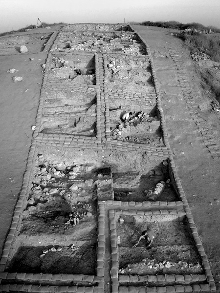
Following their survey in 1998, the Pittsburgh Theological Seminary initiated the excavation of Tel Zayit in 1999, under the direction of R. E. Tappy. In the first three seasons of fieldwork (1999–2001), the project opened nearly 1,000 sq m on the acropolis (area A), the lower settlement (area L), and the eastern slope (area T, a step-trench).
EXCAVATION RESULTS
THE LATE BRONZE AGE. The area T step-trench yielded roughly 4.7 m of depositional history from the Late Bronze Age, incorporating at least four major phases of occupation, with a 2 m-thick deposit resulting from a fierce destruction of the city by fire sometime in the early to mid-Late Bronze Age IIB (comparable with Lachish VII–VI). Both locally made and imported pottery provides a full ceramic sequence, which includes a large sample of Cypriot base-ring I–II, white-slip I–II, and knife-shaved wares.
Mud bricks near the foot of the step-trench in area T appear to represent two perpendicular walls. Together with the remains of a plastered, stone-lined installation, this level constitutes the earliest construction thus far exposed at the site, attributable to an early phase of the Late Bronze Age (I?) or perhaps even the Middle Bronze Age.
At least three of the construction phases date to the Late Bronze Age II (fourteenth–thirteenth centuries BCE). The earliest of these represents the most significant Late Bronze Age level discovered thus far at Tel Zayit. The architectural elements point to a very large public building with an official function, possibly a fortress or palace. It was destroyed by a fire. Wall foundations were built of large unworked rubble stones covered by a leveling layer of pebbles and other small stones, with a mud-brick superstructure. A charred negative from a large, burned-out wooden support beam provides further clues to the construction of the building. Numerous fragments of plaster lay scattered throughout the debris from the collapse, the thinner pieces likely representing the coating that originally covered the brick walls; while the thicker ones, which included significant quantities of crushed seashells, may have comprised part of the floors in the upper stories. Though the step-trench has revealed only the northernmost portion of a large room of the structure, it is clear that the original building was impressive in scale and construction. Its collapsed remains accumulated to a depth of some 2 m.
Uncovered from the next phase was a massive stone foundation that likely once supported the superstructure of a substantial mud-brick wall. The foundation was relatively poorly constructed of variously sized fieldstones. An associated floor and other superimposed floors produced Late Bronze Age pottery and small objects.
The latest phase included the remains of a mud-brick wall, the bricks having been laid on their narrow sides. A bichrome jug imitating Cypriot base-ring types lay on the principal but poorly preserved floor level associated with this phase. A series of closely spaced surfaces indicates an appreciable phase of occupation toward the end of the Late Bronze Age, following the massive conflagration in the city. These deposits contain locally made pottery—Canaanite jars and Late Bronze Age goblets—but are almost completely void of imports.
THE IRON AGE. During the 2000 season, the outlines of a sizeable public building emerged (O-20). Debris rested on a surface surviving in only a small patch, though the walls that framed the general area defined at least three different rooms inside the complex. One of the rooms included two pits rich in content, both appearing to have functioned as small cellars or indoor silos. Each pit yielded significant quantities of restorable diagnostic pottery from the late tenth–ninth centuries BCE. At the bottom of one of the pits lay nearly 20 perforated clay balls. The imprint of woven cloth, visible both within the perforations and on the exterior surfaces surrounding them, suggests that these items functioned as fermentation stoppers. In the second pit, one stopper still rested on the bottom of a broken jar. The entire area suffered destruction by fire, probably sometime around the mid-ninth century BCE, perhaps wrought by an Aramean incursion into the region.
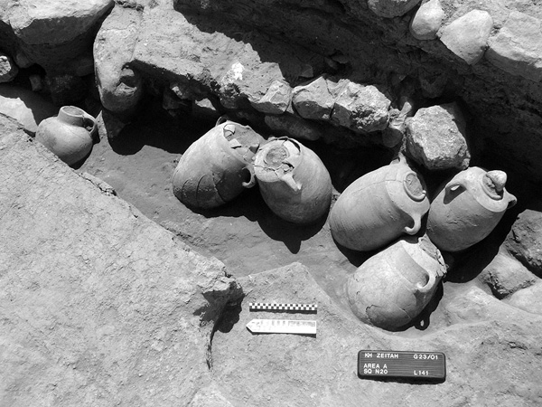
Most of the levels belonging to the latter part of the Iron Age II (the seventh century BCE) seem to have been destroyed by the Persian–Roman period remains built directly over them. The Persian period floors, however, sealed an earlier stratum, possibly dating to the eighth century, with portions of two closely spaced walls at an odd angle to each other. A floor composed of dark gray ash with patches of brown, brick-like material covered the narrow space separating the walls. Five large jars and a globular-shaped jug rested on the floor and leaned against the wall.
THE PERSIAN–HELLENISTIC PERIODS. In addition to the abovementioned Persian period remains, a significant assemblage of pottery fragments from the Persian–Hellenistic periods was retrieved at Tel Zayit. Well-preserved occupational levels from these periods have not survived, however, due to heavy disturbances during the construction of the Roman period fortress and from numerous late pits and intrusive modern trenches.
THE ROMAN PERIOD. The latest surviving architectural feature in area A consists of a large well-constructed public building, massive in scale relative to the overall area of the acropolis. The structure’s thick walls first appeared only 15 cm beneath the surface (K-20). Originally, the building likely covered the entire summit and functioned as a fortress guarding the entrance to the strategic valley immediately east of the site. While many of the original surfaces inside the building’s entryway suffered destruction from later intrusions, several clear phases of flooring survived inside the fortress (northeastern K-20). The main surface consisted of crushed yellow limestone gravel, laid above a 25 cm-thick layer of brown soil with much brick material. The floor had been thoroughly cleaned; virtually no pottery appeared on it. The latest pottery recovered from the sub-floor makeup of the last plaster surface provides a reliable construction date (terminus post quem) for that building phase in the third century CE, or Late Roman period. Portions of the fortress may have survived into the Crusader–Ayyubid periods, when the settlement belonged to the Duchy of Ashkelon. Further work is required to trace the full outline of the building. In addition to the fortress, local residents have recovered at least two Roman milestones near the foot of the tell.
THE OTTOMAN PERIOD. Excavation in area L revealed the stone foundations of a rectilinear domestic house or small agricultural building. Immediately to its south was a small, possibly open-air courtyard displaying a composite surface of cobbles and beaten earth. Nearly 89 percent of the ceramic corpus recovered from these structures, including a sequence of Ottoman-style lamps and Gaza gray ware, dates to the late Ottoman period. The village represented by these remains may relate to the settlement mentioned in the survey by Conder and Kitchener.
CONCLUSIONS
All of the architectural elements from every historical period described above adhere to the same northwest–southeast orientation. Nowhere does the architecture run perpendicular or parallel to the line of the existing eastern slope, which has failed to show any trace of a fortification system, such as a city wall or rampart. Consequently, it may be suggested that much of the easternmost portion of the site is now missing, and that the original town limits extended as far east as the tributary branch of
RON E. TAPPY
THE SITE
Tel Zayit (Khirbet Zeitah el-Kharab) lies in the strategic Beth Guvrin Valley of the Shephelah, approximately 30 km east of Ashkelon and 7 km north–northwest of Lachish, near Tel Burna (Tell
HISTORY OF RESEARCH
Until recently, neither Tel Zayit nor the valley in which it lies had received significant archaeological attention. When C. R. Conder and H. H. Kitchener encountered the site in March 1875, they recorded seeing only “a little hamlet of mud in a valley, with low hills on either side,” and “a well to the north.” The direct precursor of the village they saw may have been established on the southern bank of